Skip to content
USRADIOGUY

USRadioguy.com

Welcome to USRadioguy.com – Unlocking the Potential of Software Defined Radio

  • Home
    • Home of USRadioguy
    • USRadioguy Newsletter
    • Tried and Tested Hardware
    • What is RTL-SDR?
    • Global Weather Data
  • Satellite Reception
    • Geo Stationary Satellites
      • Geo-stationary Satellite Imagery Reception
      • GOESTOOLS on the PI
      • Update Goestools for GOES 18,19
      • Receiving GOES with SatDump CLI Mode
      • GOES receiving in Windows for SatDump GUI
      • Decoding EWS-G1/EWS-G2
      • GOES GRB Reception WIP
      • Optimizing a WIFI Grid Antenna for Maximum Efficiency
    • APT Satellites
      • APT RECEPTION
      • Satdump for Meteor and NOAA decoding
      • METEOR M2- Series
      • WxtoImg Fix
      • Converting to new TLE format
      • Layering Fire and Hotspot Data on Meteor Sat Imagery
      • HRPT Satellite Tracking and Capture
    • Receiving Other Satellites
      • Inmarsat Decoding
      • Receiving the Funcube Amateur Satellite
    • User Maps and Dish Pointers
      • Satellite Dish Pointer
      • User Global Ground Station Maps
      • Usermap rendered with Cesium
      • Global Map of Govt Dish Stations
    • Satellite Details & Information
      • ORBITAL DYNAMICS 101
      • HRIT/EMWIN & GRB Defined
      • Mesoscale Imagery Defined
      • Viterbi, R/S Errors, Packets
      • GOES BAND IMAGERY
      • Stray Light Zone (SLZ)
      • Drifting a geostationary satellite
      • GOES-R Series Multimedia Tour
      • Online Satellite Imagery and Information
      • Satellite Frequencies
      • Solar and Space Weather
  • Satellite Imagery
    • IMAGERY- Current GOES East & West HRIT Satellite Imagery
    • IMAGERY- GOES 16&18 – Past 96 Hours of Imagery
    • High Resolution Imagery
    • Daily 3D view of Earth
    • NOAA APT Satellite imagery
    • PlanetMaker
    • GOES16 A full year of received imagery
  • Imagery Processing
    • Custom Color Lookup Table & Gradients
    • GOES-R Custom Imagery Scripts
    • Global geo-ring composites
    • MODIS VIIRS Global Coverage
    • 3D Satellite Tracking
    • The quest for True Color Imagery
    • 3D animation of realtime data
    • Layering Geo-Spatial Fire Data into Satellite Imagery
    • Orbital dynamics and the Moon
    • National Hurricane Data
  • News, VLOGS & BLOGS
    • News & USRadioguy Blogs
    • USRadioguy VLOGS
  • Project Lab
    • Orbital Information and Visualizations
      • Enhanced Planet Earth
      • Satellites in Orbit
      • Solar System
      • Objects in Orbit
    • Current Station Weather
      • Current Groundstation Weather
      • Global Weather Data
      • Space Weather
    • WWII RADIO
      • WWII K-24 Aerial Camera
      • WWII RADIO
      • RADIO SET SCR-284
      • VS-3 VIBRATOR CONVERSION
      • VIBRATOR CONVERSION MODULE
      • BD-71 Field Switch Board and EE-8B Field Telephones
      • R-100/URR 1944 MORALE RADIO
      • A PORTABLE WWII ERA “MORALE RADIO”
      • AN/GRR-5 THE ANGRY 5
      • WWII Audio Page
    • Raspberry Pi Projects
      • ADS-B Reception
      • Allsky Camera
      • Pi Based Picture Frame
      • PI Based Broadcastify Server
      • Solar Power for PI
    • Hubble Space Telescope Data Processing
    • Zombie Satellites
    • DRONES
  • About Me
    • About Usradioguy
      • SETEC Astronomy
    • Tried and Tested Hardware
    • Rare Captures
    • My Other Interests
    • Presentations
    • Merchandise
    • Privacy Policy
  • Home
  • Allsky Camera

Allsky Camera

Allsky Camera Build

An Allsky camera is a specialized camera used in meteorology and astronomy for capturing a photograph of the entire sky.  Whole sky cameras typically use a fisheye lens that takes in an extremely wide, hemispherical image. Such lenses were originally developed for use in meteorology.

Click to explore the Allsky Camera

Timelapse video of the Allsky Camera can be viewed by clicking on the “PLAY” icon from within the main Allsky Page.


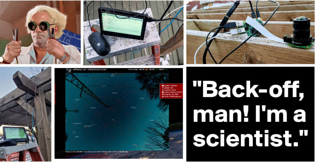
I wanted to try and build a cheap all-sky camera designed to take pictures of the entire sky over a certain amount of time, and monitor meteor showers, astronomical phenomena, and weather (clouds). Dew and Frost build-up can be a concern, so I am using two fans, one on the PI itself that is controlled by temperature script and a second that blows the warm air generated by the PI to circulate the warm air across the lens and through the dome.

Materials:

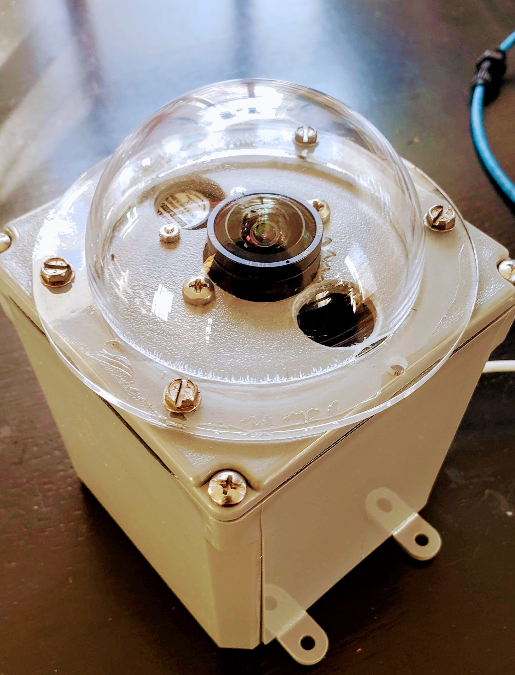
  • Raspberry Pi Q Camera
  • Arducam CS Lens, 120 Degree Ultra Wide Angle
  • Raspberry Pi 2, 3, or 4
  • Fan Shim Fan
  • Fan for dome heat
  • 64 GB micro SD card
  • Short right angle USB cable
  • Carlon 4 x 4 x 4 PVC Enclosure Box
  • Acrylic dome
  • Gore Vent I absolutely use these on every single outdoor electronic project I build

Software:

  • Current Version of Raspberry Pi OS
  • Allsky Raspberry PI software by T Jaquin

Installation of the software on the PI is fairly straightforward, and once it is installed you can run the Web UI page by going to HTTP://allsky.local or HTTP://yourallskyipaddress/

My AllSky Camera Page

I used the included website tools that come with the AllSky software to set up an all-sky server on my website. (note that I modified the HTML, and CSS from the original to my preferences.) If you intend to operate the website tools on your remote website, and not from the pi, you will need PHP 7.3 or later to process the images and thumbnails. Currently, the Allsky software does not create the thumbnails on the remote server for the Timelapse .mp4 videos due to no FFMPEG support with PHP.

USRadioguy AllSky Camera Imagery

Testing the system in -2° F temps, set it up outside without the case so I could try and focus the lens. Used a 7″ HDMI screen from another project to monitor the image while I made adjustments.

“You can’t keep a good scientist down.”- Dr. Emmet Brown, ‘Back To The Future’.
Everything inside a 4″x4″ enclosure

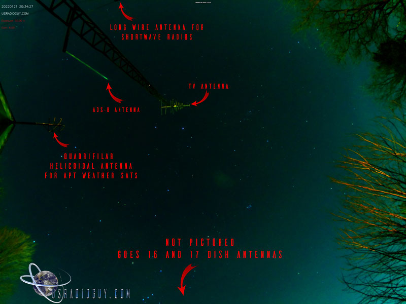
What are all those antennas?


In the display below, clicking on the Date, Latitude or Longitude will allow you to set for your location ? in far right corner show the keyboard shortcuts that allow you to select or deselect properties.

If you want to just explore more of the night sky I have a simple fullscreen planetarium running using the same virtual sky script that is running on my All-Sky Camera Page

Full Screen Planetarium

Enough of the stars? Build your own planet!

USRadioguy Planetmaker 4.0

I hope I have helped you in some way, would you consider making a donation to offset the cost of running this website? Every little bit helps!

Hardware Humor Imagery Processing Interesting stuff you should know! Launch News Life News Product Review Satellites Science Software Space Weather Uncategorized VLOG

Satellite And Weather Related Feeds

  • CIMSS Satellite Blog
  • USRadioguy.com
  • wildfires
  • NASA Earth Observatory
  • SPC Particularly Dangerous Situation (PDS) Tornado/Severe Thunderstorm Watch
  • satellites
  • Satellites News -- ScienceDaily
  • Satellite Liaison Blog
Trout Fire in New Mexico produces a pyrocumulonimbus cloud
Blowing dust in Argentina
Canadian wildfire smoke over Alaska
End Of Life for NOAA 15 and 19?….not so fast…
Vitality GOES
Vitality GOES
Decommissioning NOAA-18
The fire cycle
Unmasking the complicated chemistry of wildfire smoke: What's in it?
NOAA unveils powerful convergence of AI and science with revolutionary Next-Generation Fire System technology
Earth’s Clouds on the Move
Seasonal Breakup in the Amundsen Gulf
Egypt’s Mediterranean Coast
SPC PDS Severe Thunderstorm Watch 399
Five historically huge solar events
65 years since the world’s first weather satellite
Investing in America: NOAA's Science, Service and Stewardship in Action
Satellite measures CO2 and NO2 simultaneously from power plant emissions for the first time
Existing international law can help secure peace and security in outer space
Small, faint and 'unexpected in a lot of different ways': Astronomers make galactic discovery
Late-Season Atlantic Hurricane-Force Low
Atmospheric River Strikes Eastern U.S.
Another Week, Another Deep South Soaker
  • Facebook Geo Stationary Satellites
  • Usradioguy Facebook
  • Instagram
  • Reddit
  • Github
  • Linkedin

Copyright © 2025 USRadioguy.com - All Rights Reserved. All material protected by Fair Use Section 107 of the Copyright Act. This site is Verified and Secured with 256 bit SSL encryption