Skip to content
USRADIOGUY

USRadioguy.com

Welcome to USRadioguy.com – Unlocking the Potential of Software Defined Radio

  • Home
    • Home of USRadioguy
    • USRadioguy Newsletter
    • Tried and Tested Hardware
    • What is RTL-SDR?
    • Global Weather Data
  • Satellite Reception
    • Geo Stationary Satellites
      • Geo-stationary Satellite Imagery Reception
      • GOESTOOLS on the PI
      • Update Goestools for GOES 18,19
      • Receiving GOES with SatDump CLI Mode
      • GOES receiving in Windows for SatDump GUI
      • Decoding EWS-G1/EWS-G2
      • GOES GRB Reception WIP
      • Optimizing a WIFI Grid Antenna for Maximum Efficiency
    • APT Satellites
      • APT RECEPTION
      • Satdump for Meteor and NOAA decoding
      • METEOR M2- Series
      • WxtoImg Fix
      • Converting to new TLE format
      • Layering Fire and Hotspot Data on Meteor Sat Imagery
      • HRPT Satellite Tracking and Capture
    • Receiving Other Satellites
      • Inmarsat Decoding
      • Receiving the Funcube Amateur Satellite
    • User Maps and Dish Pointers
      • Satellite Dish Pointer
      • User Global Ground Station Maps
      • Usermap rendered with Cesium
      • Global Map of Govt Dish Stations
    • Satellite Details & Information
      • ORBITAL DYNAMICS 101
      • HRIT/EMWIN & GRB Defined
      • Mesoscale Imagery Defined
      • Viterbi, R/S Errors, Packets
      • GOES BAND IMAGERY
      • Stray Light Zone (SLZ)
      • Drifting a geostationary satellite
      • GOES-R Series Multimedia Tour
      • Online Satellite Imagery and Information
      • Satellite Frequencies
      • Solar and Space Weather
  • Satellite Imagery
    • IMAGERY- Current GOES East & West HRIT Satellite Imagery
    • IMAGERY- GOES 16&18 – Past 96 Hours of Imagery
    • High Resolution Imagery
    • Daily 3D view of Earth
    • NOAA APT Satellite imagery
    • PlanetMaker
    • GOES16 A full year of received imagery
  • Imagery Processing
    • Custom Color Lookup Table & Gradients
    • GOES-R Custom Imagery Scripts
    • Global geo-ring composites
    • MODIS VIIRS Global Coverage
    • 3D Satellite Tracking
    • The quest for True Color Imagery
    • 3D animation of realtime data
    • Layering Geo-Spatial Fire Data into Satellite Imagery
    • Orbital dynamics and the Moon
    • National Hurricane Data
  • News, VLOGS & BLOGS
    • News & USRadioguy Blogs
    • USRadioguy VLOGS
  • Project Lab
    • Orbital Information and Visualizations
      • Enhanced Planet Earth
      • Satellites in Orbit
      • Solar System
      • Objects in Orbit
    • Current Station Weather
      • Current Groundstation Weather
      • Global Weather Data
      • Space Weather
    • WWII RADIO
      • WWII K-24 Aerial Camera
      • WWII RADIO
      • RADIO SET SCR-284
      • VS-3 VIBRATOR CONVERSION
      • VIBRATOR CONVERSION MODULE
      • BD-71 Field Switch Board and EE-8B Field Telephones
      • R-100/URR 1944 MORALE RADIO
      • A PORTABLE WWII ERA “MORALE RADIO”
      • AN/GRR-5 THE ANGRY 5
      • WWII Audio Page
    • Raspberry Pi Projects
      • ADS-B Reception
      • Allsky Camera
      • Pi Based Picture Frame
      • PI Based Broadcastify Server
      • Solar Power for PI
    • Hubble Space Telescope Data Processing
    • Zombie Satellites
    • DRONES
  • About Me
    • About Usradioguy
      • SETEC Astronomy
    • Tried and Tested Hardware
    • Rare Captures
    • My Other Interests
    • Presentations
    • Merchandise
    • Privacy Policy
  • Home
  • GEO-RING COMPOSITES

GEO-RING COMPOSITES

Creating Global Composites from multiple satellites.

With more and more geosynchronous satellites being placed in orbit, and with more and more individuals and groups devising ways to receive and decode the transmissions from these satellites, the possibility for the amateur to truly capture the entire earth is now a reality. The global community of dedicated and resourceful satellite enthusiasts really exemplifies, how, folks from many different countries and backgrounds can work together and share expertise, knowledge, equipment, and now satellite imagery. While long the purview of government organizations such as NOAA (which shares data for free), and others such as EUMETSAT (which typically charges a subscription fee) anyone just about anywhere has readily accessible global satellite imagery via the internet.

While not new, compositing imagery from other users had typically been done through polar-orbiting satellites using software such as WxtoImg to create pieced-together composites from receivers all over the world. Also, sites such as AMIGOS allow users, with a bit more effort, to composite Meteor Imagery into larger composites.

Now with other satellite enthusiasts sharing their imagery, along with the ability to receive your own imagery, these images can all be put together, by amateurs, a home, to render the entire planet as viewed from geostationary orbits.

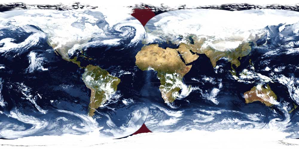
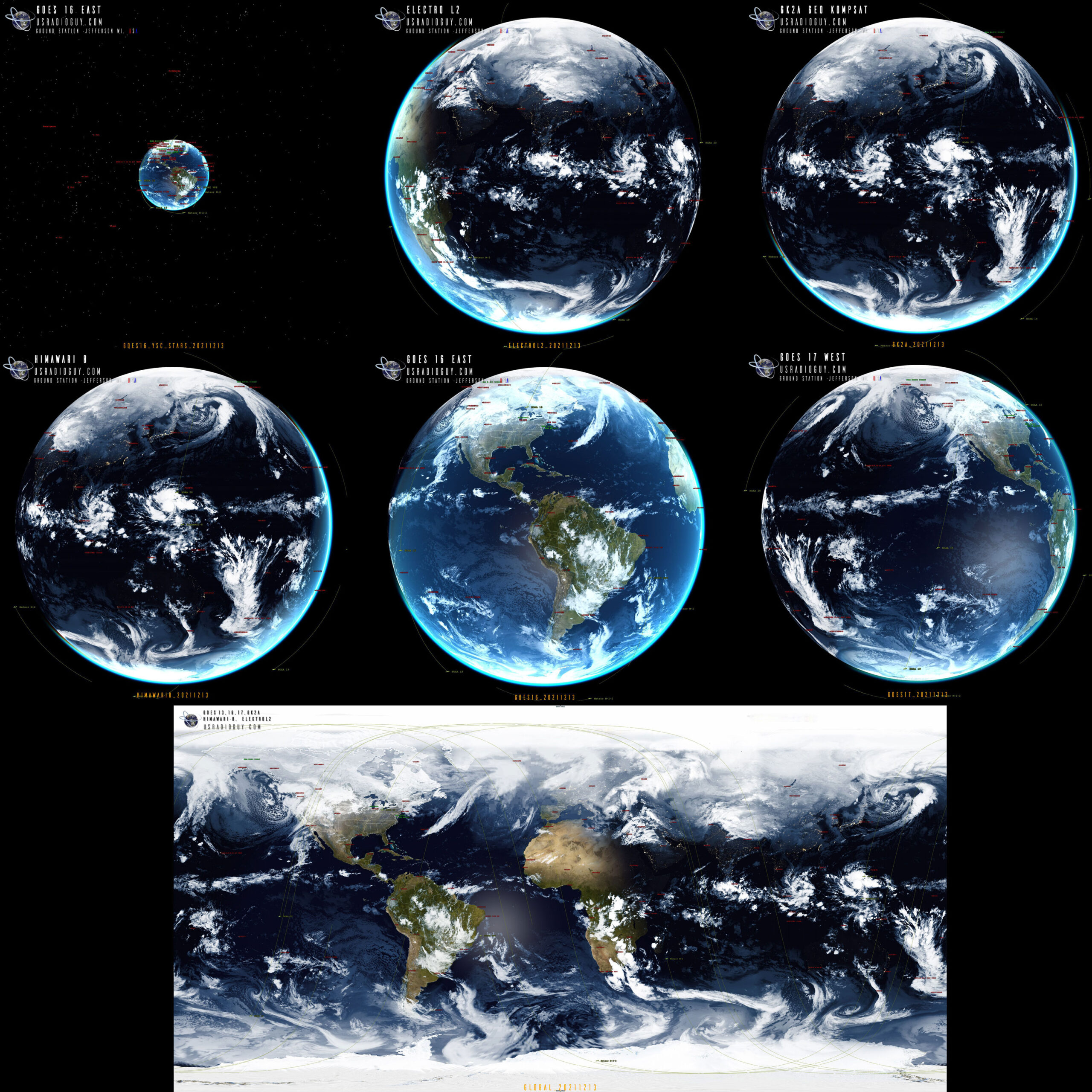
In my case, with my two receiving dish stations, I have the ability to receive GOES 16 and 18, in HRIT, and GOES-18 Relays HIMAWARI-9 imagery as well. (Note: I also receive GOES 15 when it is taken out of on-orbit storage and placed on active status.) That gives me coverage of around 2/3 of the planet, running from roughly the Western Sahara to Malaysia and Australia. But when the full disk is projected into an equirectangular projection gaps are left in the northern and southern parts of the earth, shown in this example using just GOES 16, 18, Himawari-9 and EWS-G1. showing the missing areas in red.

Note that the EWS-G1 imagery comes from a collaborative effort between @ZSztanga (who receives the imagery) and @aang254 (who wrote the decoder) As of this writing, I believe this is the only source of EWS-G1 imagery outside of NOAA and the US Military!

This animation describes the coverages of APT Low Earth Orbit Satellites I receive and Geo-stationary satellites used in these composites.
This animation shows the 6 geostationary satellites used in compositions

So, How to fix this? We need more satellite coverage. I am going to use imagery from the Russian Electro L2 Geostationary Satellite that they share on http://electro.ntsomz.ru/ and Geo Kompsat 2-A, which I get from a friend with a receiving station in the Philipines.

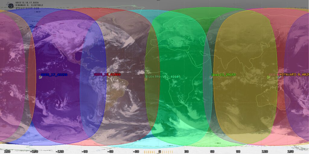
In the picture below I have identified by color, the primary coverage of each satellite. Remember, there is quite a bit of overlap between each satellite.

Ground Path Coverages

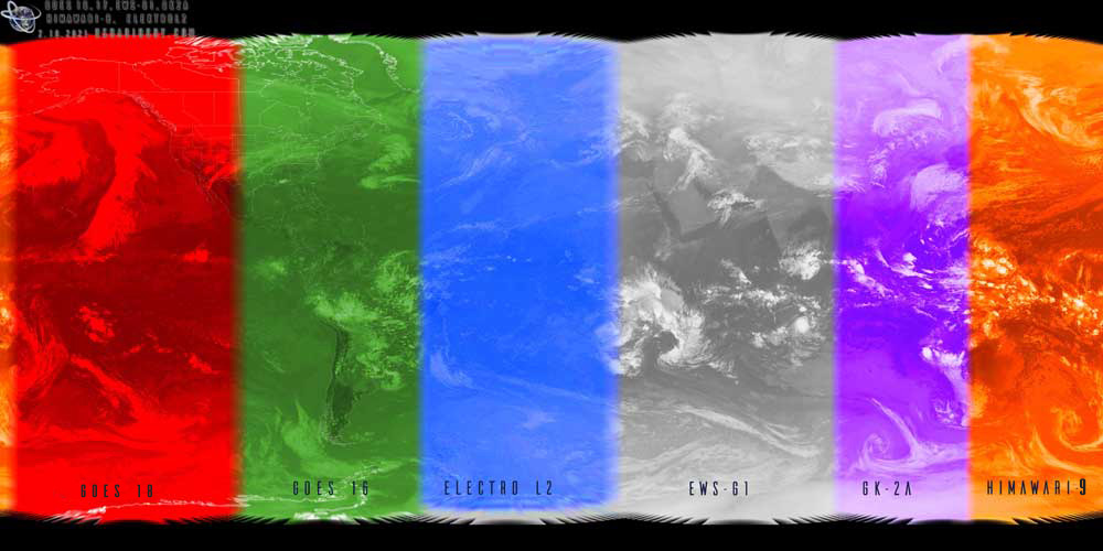
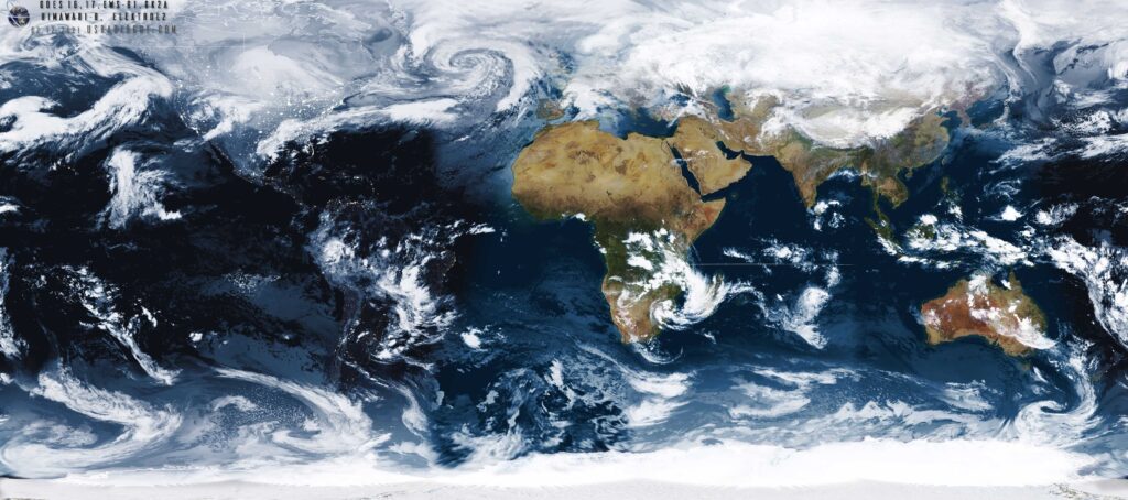
With these 6 satellites, I create the Geo-Ring composite shown below:

Here is the basic workflow for how I create the global composite.

  1. Gather IR imagery from the same time frame, within about 30 minutes. I use Band 13 from GOES 16 and 18, Himawari 8 Band 4 IR, EWS-G1 band 4, ElectroL2 Band 4 and GK2A channel 4.
  2. Then Sanchez is used to stitch and recomposite the imagery into one global view.
    using this basic structure: F:/Sanchez/Sanchez.exe” reproject -s “F:\GEORING\*.*” stitch -T 2021-02-12T13:00:00 -S 0.8 -f -u “F:\Sanchez\Resources\xplanet2.jpg” -v –nocrop -r 2 -o “F:\Satelliteoutput\GEORING_DayNight.jpg”
  3. I chose not to auto crop my imagery, as I do some post-processing and also create 3D imagery as well, Shown here: 3D imagery from received data
  4. In the example above, in my script, I use xplanet to generate a true color underlay to match the time of the satellite imagery to give and day/night image.

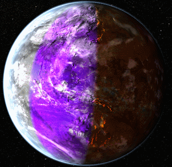
In post-processing, I use three.js processing to turn the rendered image back into a 3-dimensional globe. The t image uses the colored representation to show the satellite coverage.

A big beachball!

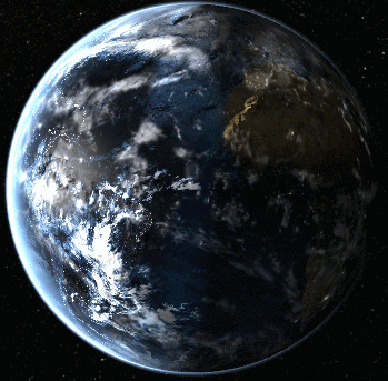
This second image shows the imagery rendered onto a three-dimensional globe using three.js

Example from December 2024 to February2025
Global Imagery Composites made on Dec 14, 2021
This is made with global satellite coverage 3/26/2022
Global SST, Sea Surface Temperatures with Geostationary Satellite imagery from GOES 16,17, Himawari-8, ElektroL2, GK2A (no EWS-G1 data)
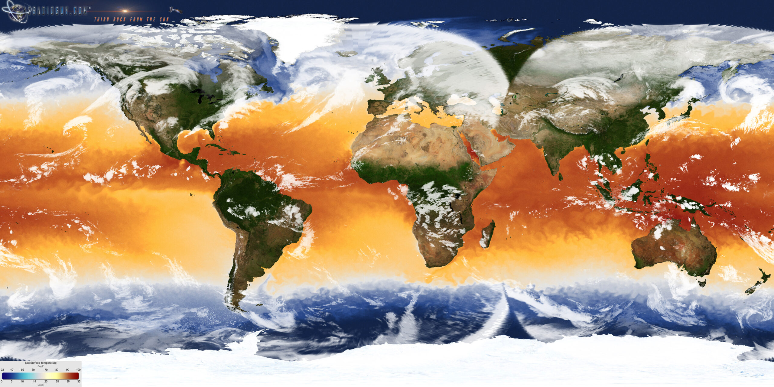
The SST image is generated on a daily basis using SST data from a variety of polar-orbiting and geostationary satellites. , including GOES, POES, Meteosat, and Metop-A. The data has a spatial resolution of about 11 km/pixel. The color scale uses blues to show the cold waters, red and orange to show the hot waters, and yellow and white to show the temperate waters. The SST data is compiled using a WMS script pulling data from https://data.noaa.gov/dataset/

Hardware Humor Imagery Processing Interesting stuff you should know! Launch News Life News Product Review Satellites Science Software Space Weather Uncategorized VLOG

Satellite And Weather Related Feeds

  • CIMSS Satellite Blog
  • USRadioguy.com
  • wildfires
  • NASA Earth Observatory
  • SPC Particularly Dangerous Situation (PDS) Tornado/Severe Thunderstorm Watch
  • satellites
  • Satellites News -- ScienceDaily
  • Satellite Liaison Blog
Using Polar2grid and Direct Broadcast files to create imagery
Cirrus over the western Great Lakes
Wildfire in Saskatchewan produces a pyrocumulonimbus cloud
End Of Life for NOAA 15,18,19?….not so fast…
GOES-19 now GOES-EAST
GOES 19 Operational Schedule
The fire cycle
March was nation's 6th warmest on record
Podcast: Could the LA Wildfires harm California's marine life?
Mapping the Tiny Plankton That Feed Giant Right Whales
Lights of Southeast Asia
The Arches That Salt Built
SPC PDS Tornado Watch 98
Five historically huge solar events
65 years since the world’s first weather satellite
Investing in America: NOAA's Science, Service and Stewardship in Action
Satellite measures CO2 and NO2 simultaneously from power plant emissions for the first time
Existing international law can help secure peace and security in outer space
Small, faint and 'unexpected in a lot of different ways': Astronomers make galactic discovery
Another Week, Another Deep South Soaker
4 May 2025 Dust and Accumulating Hail
Southern Plains Deluge
  • Facebook Geo Stationary Satellites
  • Usradioguy Facebook
  • Instagram
  • Reddit
  • Github
  • Linkedin

Copyright © 2025 USRadioguy.com - All Rights Reserved. All material protected by Fair Use Section 107 of the Copyright Act. This site is Verified and Secured with 256 bit SSL encryption