
Drifting a geostationary satellite
Why does a geostationary satellite need to be moved?
Satellites are launched via rocket and very quickly placed into a geosynchronous transfer orbit or geostationary transfer orbit (GTO). A GTO is highly elliptic. Its perigee (closest point to Earth) is typically as high as low Earth orbit (LEO), while its apogee (furthest point from Earth) is as high as a geostationary (or equally, a geosynchronous) orbit. That makes it a Hohmann transfer orbit between LEO and GSO.
Using onboard spacecraft thrusters, the satellite is placed into its intended orbit longitude. where they normally stay for many years. As time passes and needs change, it can be helpful to move satellites to new orbit longitude positions. This is usually done through a process known as “Drifting”.
How do you DRIFT a Satellite???
Let’s start with the basics using the GOES 17 move as our example. On January 10th, 2023, GOES-17 will begin moving east from the orbital longitude position of 137.3° West to its new orbital longitude position of 104° West. Normally, a geosynchronous satellite like GOES-17 remains in a fixed position in the sky relative to Earth’s rotation. This won’t be the case once the drift process gets underway. During its relocation, GOES-17’s five main instruments (ABI, GLM, SUVI, SEISS, and EXIS) will be turned off and placed in safe or diagnostic mode.
Normally, satellites maintain the same distance from Earth while operational (i.e. transmitting data). When required to initiate an orbit repositioning to a further east longitude orbit position, the orbital position is gradually changed, easterly, typically over a few days or weeks till the new position is reached. (All the while avoiding all the other geostationary satellites, some of which at only 10’s of km apart!***)
To accomplish this during the drift period, GOES-17’s altitude will actually be lowered slightly (by about 60 miles). This maneuver uses the resulting increase in gravity on GOES-17 to help nudge the satellite to begin moving into its new orbital position. This actually changes the geostationary orbit to a slightly elliptical orbit. Around February 8th, as GOES-17 gets close to its new orbital position, NOAA’s operations team raises the satellite back to its normal operating altitude, which will be on February 10th, 2023.
The drift maneuver must also take into account relevant harmonics of the gravity field at the altitude of geostationary orbits, as well as solar radiation pressure and third-body perturbations caused by the Moon and the Sun.
The total distance to be traveled is 33.03 degrees. This can be calculated by subtracting the starting position (137.2) from the desired ending position (104.17). To calculate the speed, we need to divide the total distance to be traveled (33.03) by the total time available for the repositioning (36 days). This gives us a speed of 0.91 degrees per day, or 0.04 degrees per hour. Therefore, to reposition the satellite from 137.2 to 104.17, it needs to travel 33.03 degrees at a speed of 0.04 degrees per hour, starting on January 10 2023 and ending on February 15th 2023. This, of course does not take into account the orbit lowering/raising manuevers.NOAA’s missions operations division uses this lowering and raising process any time its geosynchronous satellites need to change orbital positions.
Geostationary orbit
Science Fiction writer Arthur C. Clarke first suggested the idea of communications satellites in geosynchronous orbit in the October 1945 issue of Wireless World. in a paper called “Extra-terrestrial Relays — Can Rocket Stations Give World-wide Radio Coverage?” Clarke realized that a radio relay station in space could serve a huge area of the earth’s surface, like a radio tower thousands of miles high. The area of space these satellites use is sometimes referred to as the Clarke Belt.
Altitude = 35,786 km from equator
Speed = 11,052 km/hr
Period = 23 Hours, 56 Minutes
All Geostationary Satellites also perform station-keeping navigation. In a year, relative to the center of the Earth, a geostationary satellite travels 80 million km. A drift of only 0.01% would result in 8000 km of drift in a year if allowed to go uncorrected. Since the velocity is 2500 meters per second, an annual budget of 50 meters per second is 2% of the total velocity. This is corrected with GOES with small thrusters when needed.
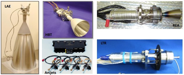
The delta-v at apogee is provided by a high-performance 450 N (101 lbf) hypergolic Liquid Apogee Engine (LAE) using hydrazine as a fuel and MON-3 (3% nitric oxide) as an oxidizer.
>Two 22 N (5 lbf) hypergolic hydrazine bipropellant thrusters (HBTs) are used for relocation, decommissioning, and as a backup to the LAE and use the same propellants as the LAE.
>Eight 22 N (5 lbf) monopropellant hydrazine reaction engine assemblies (REAs), configured in half systems, are used for settling burns prior to LAE ignition, attitude control during LAE firings, and relocations.
>Sixteen 90 mN (20 mlbf) monopropellant hydrazine LTRs, configured in half systems, are used for momentum management and station-keeping.
>Four 225 mN (50 mlbf) arcjets are used for station-keeping. The low thrust, highly predictable, stable Liquid Apogee Engine, Hydrazine Bipropellant Thruster and Hydrazine REA and arcjets allows the payload to continually operate through thruster use.
N = Newtons, mN = Micro Newtons, lbf = Pound of force
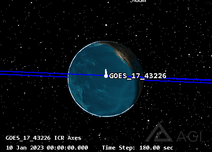
This graphic is exaggerated to show the movement of the satellite, this, of course, would not be this great in reality
But, you may ask, what if I want to drift a satellite westward?
If there is a need to move a satellite westwards, the above procedure is modified to raise it temporarily to a higher orbit, so it gradually goes backwards in longitude.
Orbital Dynamics in action.
The graphics above and below I created using ANSYS Software Tool Kit Pro using current TLE’s (Two Line Element sets) from Celestrak.
The two mp4 graphics below, both use the same timeline (January 1st to January 7th 2023) and orbital elements, the first one is rendered in 3D, and the second is in 2D. I have included the geostationary satellites with the ‘sensors’ displayed to show the coverages as they travel in relation to the earth. I have also included Polar Orbiting Satellites such as NOAA 15,18,19 and others with their sensors shown to give you an idea of how they scan the planet from an LEO (Low Earth Orbit).
***Note that some of these satellites are separated from each other by as little as one tenth of a degree longitude. While that may seem like very little separation, and it is, at geosatellite altitudes (nearly 36,000 km), this corresponds to an inter-satellite spacing of approximately 73 km (some are much closer together, 10 km, or just 4 seconds apart!). The major consideration for spacing of geostationary satellites is the beamwidth at-orbit of uplink transmitters, which is primarily a factor of the size and stability of the uplink dish, as well as what frequencies the satellite’s transponders receive; satellites with discontiguous frequency allocations can be much closer together.
See my article on The Kessler Syndrome
To be thourough, one must also understand that this does not account for the majority of The GEO Belt clutter. Far bigger concern are misbehaving satellites like the Galaxy 15 “Zombiesat” and other orbital debris.
Theoretical Geostationary Satellite Drift Calculator
As of January 2023, there are 539 Geostationary satellites in orbit.
Name Common name Orbit Inc
00001A USA 148 -179.9 9.6
12061B YAMAL 300K -177.1 0.0
13036A MUOS-2 -177.0 2.7
09008A NSS-9 -177.0 0.0
13004A TDRS 11 -174.3 2.9
99046A ABS-7 -171.5 2.9
02055A TDRS 10 -171.2 8.3
02057A NSS-6 -169.6 1.8
91054B TDRS 5 -167.7 14.2
00024A USA 149 (DSP 20) -165.5 12.1
17004A SBIRS GEO-4 (USA 273) -159.5 2.2
13050A AEHF-3 (USA 246) -155.0 1.8
04008A EUTELSAT 7A -139.3 2.3
00067A AMC-6 (GE-6) -139.1 0.0
05046B SPACEWAY 2 -139.0 2.0
18022A GOES 17 -137.4 0.1
22021A GOES 18 -137.0 0.0
13041A WGS F6 (USA 244) -135.3 0.0
00081B AMC-8 (GE-8) -135.0 2.6
99060A AMC-4 (GE-4) -135.0 1.7
05041A GALAXY 15 (G-15) -133.0 0.0
01011A EUTELSAT 133 WEST A -132.9 3.9
04017A AMC-11 (GE-11) -131.1 0.1
96054A AMC-1 (GE-1) -131.0 5.8
03008A USA 167 -130.2 8.2
17026A SES-15 -129.2 0.0
03013B GALAXY 12 (G-12) -129.1 3.4
08063A CIEL-2 -128.9 0.0
10008A GOES 15 -128.1 0.4
03044A GALAXY 13 (HORIZONS-1) -127.1 0.0
20056C GALAXY 30 (G-30) -125.1 0.0
08038B AMC-21 -125.0 0.1
01009A USA 157 (MILSTAR-2 2) -124.3 10.1
08024A GALAXY 18 (G-18) -123.1 0.0
03034A GALAXY 23 (G-23) -121.0 0.1
95060A USA 115 (MILSTAR-1 2) -120.1 13.5
05019A DIRECTV 8 -119.1 0.0
10010A ECHOSTAR 14 -119.0 0.0
07009A ANIK F3 -118.8 0.0
16038B EUTELSAT 117 WEST B -117.1 0.0
13012A EUTELSAT 117 WEST A -116.9 0.0
13058A FM-6 -116.2 0.1
96020A INMARSAT 3-F1 -116.0 7.7
20096A SXM-7 -115.4 0.0
10053A XM-5 -115.3 0.0
11059A VIASAT-1 -115.2 0.0
15010B EUTELSAT 115 WEST B -115.0 0.0
12075B MEXSAT 3 -114.9 0.0
15056A MORELOS 3 -113.2 3.6
06020A EUTELSAT 113 WEST A -113.0 0.0
97065A USA 134 -112.4 11.1
21118A STPSAT-6 -111.7 0.0
06054A WILDBLUE-1 -111.2 0.0
04027A ANIK F2 -111.2 0.0
09035A TERRESTAR-1 -111.1 3.3
06003A ECHOSTAR 10 -110.2 0.0
02023A DIRECTV 5 (TEMPO 1) -110.2 1.3
08035A ECHOSTAR 11 -110.1 0.0
17014A ECHOSTAR 23 -110.0 0.0
00076A ANIK F1 -109.3 1.6
02062A NIMIQ 2 -109.3 6.1
95019A AMSC 1 -107.5 12.0
05036A ANIK F1R -107.4 0.7
13014A ANIK G1 -107.4 0.0
12035A ECHOSTAR 17 -107.2 0.0
16041A MUOS-5 -105.1 5.5
04041A AMC-15 -105.1 0.1
17063A SES-11 (ECHOSTAR 105) -105.0 0.0
09033A GOES 14 -104.6 0.5
11035A SES-3 -103.1 0.1
15026A DIRECTV 15 -102.9 0.0
07032A DIRECTV 10 -102.9 0.0
09075A DIRECTV 12 -102.8 0.0
10005A SDO -102.2 31.8
10061A SKYTERRA 1 -101.4 2.5
06043A DIRECTV 9S -101.3 0.0
10016A SES-1 -101.1 0.0
19034A AT&T T-16 -100.9 0.0
12009A MUOS-1 -100.0 3.0
14078B DIRECTV 14 -99.3 0.0
08013A DIRECTV 11 -99.3 0.0
06023A GALAXY 16 (G-16) -99.1 0.1
08039A INMARSAT 4-F3 -98.0 3.3
16079A ECHOSTAR 19 -97.2 0.0
08045A GALAXY 19 (G-19) -97.1 0.1
94084A USA 107 (DSP 17) -96.6 14.6
16035A INTELSAT 31 (IS-31) -95.1 0.0
14062A INTELSAT 30 (IS-30) -95.1 0.0
07036A SPACEWAY 3 -95.0 0.4
02030A GALAXY 3C (G-3C) -94.9 0.1
12019A AEHF-2 (USA 235) -94.3 3.5
99071A GALAXY 11 (G-11) -93.2 3.2
08016A ICO G1 -92.9 4.1
12026A NIMIQ 6 -91.2 0.0
07016B GALAXY 17 (G-17) -91.1 0.0
94009A USA 99 (MILSTAR-1 1) -90.0 15.4
05022A GALAXY 28 (G-28) -89.1 0.0
13075A TKSAT-1 (TUPAC KATARI) -87.3 0.0
11049A SES-2 -87.1 0.1
02015B ASTRA 3A -86.8 7.5
09034A FM-5 -86.2 0.0
21049A SXM-8 -85.3 0.0
06049A XM-4 (BLUES) -85.2 0.1
05008A XM-3 (RHYTHM) -85.2 0.0
16082B STAR ONE D1 -84.1 0.0
06054B AMC-18 -83.1 0.1
08044A NIMIQ 4 -82.0 0.0
15054B ARSAT 2 -81.1 0.0
10065A HYLAS 1 -79.1 2.1
15026B SKY MEXICO-1 -78.8 0.0
11054A QUETZSAT 1 -77.1 0.0
10006A INTELSAT 16 (IS-16) -76.3 0.0
16071A GOES 16 -75.3 0.1
12062A STAR ONE C3 -75.1 0.0
17023B SGDC -74.9 0.0
14011A AMAZONAS 4A -74.0 0.0
09050A NIMIQ 5 -72.8 0.1
01025A ASTRA 2C -72.5 4.7
97050A AMC-3 (GE-3) -72.1 4.7
14062B ARSAT 1 -71.9 0.0
15034B STAR ONE C4 -70.1 0.0
21069A STAR ONE D2 -70.1 0.0
17029A VIASAT-2 -70.0 0.0
18079A AEHF-4 (USA 288) -67.5 2.4
17017A SES-10 -67.0 0.0
16014A EUTELSAT 65 WEST A -65.3 0.1
08018B STAR ONE C2 -65.1 0.1
11021A TELSTAR 14R -63.1 0.0
18059A TELSTAR 19V -63.1 0.0
02011A TDRS 9 -62.3 9.1
10034A ECHOSTAR 15 -61.7 0.0
12065A ECHOSTAR 16 -61.6 0.0
16039B ECHOSTAR 18 -61.4 0.0
17053A AMAZONAS 5 -61.1 0.0
09054A AMAZONAS 2 -61.1 0.0
13006A AMAZONAS 3 -61.1 0.0
12045A INTELSAT 21 (IS-21) -58.1 0.0
15039A INTELSAT 34 (IS-34) -55.5 0.0
15005A INMARSAT 5-F2 -55.0 0.0
98006B INMARSAT 3-F5 -54.0 6.5
12057A INTELSAT 23 (IS-23) -53.1 0.0
13024A WGS F5 (USA 243) -52.6 0.0
01039A INTELSAT 902 (IS-902) -50.1 2.6
00043A INTELSAT 9 (IS-9) -50.0 7.3
01033A USA 159 (DSP 21) -49.1 11.5
88091B TDRS 3 -48.9 13.7
18012B SES-14 -47.6 0.0
93003B TDRS 6 -45.8 14.1
09064A INTELSAT 14 (IS-14) -45.0 0.0
17007B INTELSAT 32E (IS-32E) -43.2 0.0
07044B INTELSAT 11 (IS-11) -43.1 0.0
03040A USA 170 -42.5 7.5
14004A TDRS 12 -41.0 3.8
13026A SES-6 -40.6 0.1
13011A SBIRS GEO-2 (USA 241) -38.1 2.0
09009A TELSTAR 11N -37.6 0.0
05003A NSS-10 (AMC-12) -37.5 2.9
17006A HISPASAT 36W-1 -36.1 0.0
17041A INTELSAT 35E (IS-35E) -34.6 0.0
18033B HYLAS 4 -33.6 0.1
08034A INTELSAT 25 (IS-25) -31.6 0.0
06007A SPAINSAT -30.1 0.1
10070A HISPASAT 30W-5 -30.1 0.0
18023A HISPASAT 30W-6 -30.0 0.0
02007A INTELSAT 904 (IS-904) -29.6 3.4
01024A INTELSAT 901 (IS-901) -27.6 0.0
19067B MEV-1 -27.6 0.0
17078A ALCOMSAT 1 -24.9 0.0
02027A INTELSAT 905 (IS-905) -24.5 3.2
99063A UFO 10 (USA 146) -22.9 8.8
12007A SES-4 -22.1 0.0
18012A AL YAH 3 -20.2 0.1
02019A NSS-7 -20.0 6.0
17059A INTELSAT 37E (IS-37E) -18.1 0.0
08030A SKYNET 5C -17.9 0.2
12061A LUCH 5B -16.3 7.4
15002A MUOS-3 -15.5 2.6
15068A TELSTAR 12V -15.1 0.0
15074A ELEKTRO-L 2 -14.5 3.1
15048A EXPRESS-AM8 -14.1 0.0
22006A USA 324 -12.9 0.2
08065B EUTELSAT 48D -12.6 1.6
17016A WGS F9 (USA 275) -12.1 0.0
17047A TDRS 13 -11.5 4.4
08003A EXPRESS-AM33 -11.2 1.2
09007A EXPRESS-AM44 -11.1 0.0
03020A HELLAS-SAT 2 -10.1 3.8
02006A ECHOSTAR 7 -8.2 0.4
15039B EUTELSAT 8 WEST B -8.1 0.1
11051A EUTELSAT 7 WEST A -7.4 0.1
10037A NILESAT 201 -7.1 0.0
22006B USA 325 -6.9 0.1
06033B SYRACUSE 3B -5.3 0.0
02035A EUTELSAT 5 WEST A -5.1 2.5
19067A EUTELSAT 5 WEST B -5.1 0.1
08022A AMOS-3 -4.2 0.0
14046A ASIASAT 8 (AMOS-7) -4.0 0.0
14058A LUCH (OLYMP) -3.8 0.0
15010A ABS-3A -3.1 0.0
07063B HORIZONS-2 -1.6 0.0
99009B SKYNET 4E -1.3 11.3
04022A INTELSAT 10-02 -1.1 0.0
20056B MEV-2 -1.0 0.0
09058B THOR 6 -0.9 0.0
08006A THOR 5 -0.8 0.0
15022A THOR 7 -0.7 0.0
15034A METEOSAT-11 (MSG-4) -0.3 0.4
17038A BULGARIASAT-1 1.8 0.0
10037B RASCOM-QAF 1R 2.8 0.0
14030A EUTELSAT 3B 3.0 0.1
10039A AEHF-1 (USA 214) 4.1 4.7
07057A ASTRA 4A (SIRIUS 4) 4.7 0.0
12036A SES-5 4.9 0.1
07046A WGS F1 (USA 195) 5.9 0.0
13022A EUTELSAT 7B 6.9 0.1
19034B EUTELSAT 7C 6.9 0.1
20005B EUTELSAT KONNECT 7.1 0.1
16005A EUTELSAT 9B 8.9 0.0
10069A EUTELSAT KA-SAT 9A 8.9 0.1
12035B METEOSAT-10 (MSG-3) 9.1 1.6
96070A INMARSAT 3-F3 9.6 7.3
09016A EUTELSAT 10A 10.0 0.0
17032A ECHOSTAR 21 10.2 3.9
19080B INMARSAT GX5 11.0 0.0
19048A COSMOS 2539 11.9 0.0
06032A EUTELSAT HOTBIRD 13B 12.9 0.1
08065A EUTELSAT HOTBIRD 13C 12.9 0.1
06007B EUTELSAT HOTBIRD 13E 12.9 0.0
10021B COMSATBW-2 13.1 0.0
11057A EUTELSAT 16A 15.9 0.1
21063A TIANLIAN 1-05 16.7 2.0
21129A SHIYAN 12 01 (SY-12 01) 16.8 0.1
19050A AMOS-17 16.9 0.0
08011A AMC-14 17.4 22.2
02001A USA 164 (MILSTAR-2 3) 19.0 9.6
07016A ASTRA 1L 19.1 0.1
11041A ASTRA 1N 19.1 0.0
06012A ASTRA 1KR 19.1 0.1
08057A ASTRA 1M 19.2 0.0
97076A ASTRA 1G 19.3 6.4
11049B ARABSAT-5C 19.9 0.1
12040A TIANLIAN 1-03 20.4 2.2
21042A SBIRS GEO-5 (USA 315) 20.8 7.3
12062B EUTELSAT 21B 21.5 0.1
10021A ASTRA 3B 23.4 0.1
00081A ASTRA 2D 23.6 7.4
13038A ALPHASAT 24.8 2.7
07056B SKYNET 5B 25.1 1.7
13044A ES'HAIL 1 25.5 0.1
18090A ES'HAIL 2 25.7 0.0
10025A BADR-5 25.9 0.0
08034B BADR-6 25.9 0.1
15065B BADR-7 (ARABSAT-6B) 25.9 0.0
06051A BADR-4 25.9 0.0
12051A ASTRA 2F 28.1 0.1
14089A ASTRA 2G 28.1 0.0
13056A ASTRA 2E 28.4 0.1
93056A UFO 2 (USA 95) 28.8 11.5
05005A XTAR-EUR 28.9 0.7
10032B ARABSAT-5A 30.4 0.1
19021A ARABSAT-6A 30.5 0.0
21001A TURKSAT 5A 30.9 0.0
12043B HYLAS 2 31.0 0.0
19049A EDRS-C 31.1 0.1
14011B ASTRA 5B 31.4 0.0
16015A IRNSS-1F 32.5 2.3
11016A INTELSAT NEW DAWN 32.7 0.0
05030A GALAXY 14 (G-14) 32.8 1.4
09008B EUTELSAT 33E 33.0 0.1
19097A SHIJIAN-20 (SJ-20) 33.4 1.3
90079A SKYNET 4C 33.4 13.8
13062A RADUGA-1M 3 34.9 2.4
19080A TIBA-1 35.4 0.1
09065A EUTELSAT 36B 35.8 0.1
15082A EXPRESS-AMU1 36.0 0.0
14006B ATHENA-FIDUS 37.7 0.0
11042A PAKSAT-1R 37.9 0.0
17040A HELLAS-SAT 3 38.9 0.1
19007A HELLAS-SAT 4 & SGS-1 38.9 0.1
15012A EXPRESS-AM7 39.9 0.0
02040B METEOSAT-8 (MSG-1) 41.4 8.1
08030B TURKSAT 3A 41.9 0.0
21126A TURKSAT 5B 41.9 0.1
14007A TURKSAT 4A 41.9 0.1
11077A NIGCOMSAT 1R 42.4 0.0
03026A THURAYA-2 44.0 6.8
17046A COSMOS 2520 45.0 0.0
18074A AZERSPACE 2 (IS-38) 45.0 0.0
21095B SYRACUSE 4A 45.4 0.0
05049B METEOSAT-9 (MSG-2) 45.7 6.2
13006B AZERSPACE 1 45.9 0.0
05041B SYRACUSE 3A 47.0 1.3
12016A YAHSAT 1B 47.5 0.0
21069B EUTELSAT QUANTUM 47.7 0.0
19007B GSAT-31 47.8 0.1
17031A GSAT-19 47.8 0.1
11034A GSAT-12 47.9 1.5
19031A YAMAL 601 48.9 0.0
15060A TURKSAT 4B 49.9 0.0
16001A BELINTERSAT-1 51.5 0.0
15023A TURKMENALEM52E/MONACOSA 51.9 0.0
11016B YAHSAT 1A 52.4 0.0
12075A SKYNET 5D 52.7 0.1
14064A EXPRESS-AM6 52.9 0.0
19051A AEHF-5 (USA 292) 54.4 4.2
12070A YAMAL 402 54.8 0.0
13034A IRNSS-1A 54.9 32.6
18089A GSAT-29 55.0 0.1
14078A GSAT-16 55.0 0.1
14017A IRNSS-1B 55.0 28.6
11022A GSAT-8 55.0 0.0
18035A IRNSS-1I 55.0 29.2
14010A EXPRESS-AT1 55.9 0.0
17025A INMARSAT 5-F4 56.4 0.0
09058A NSS-12 56.9 0.0
98050A ASTRA 2A 57.1 3.6
09017A WGS F2 (USA 204) 57.5 0.0
14023B KAZSAT-3 58.4 0.0
12008A BEIDOU 11 58.7 1.7
16053B INTELSAT 33E (IS-33E) 59.9 0.0
19014A WGS 10 (USA 291) 60.3 0.0
16052B USA 271 60.9 0.6
04007A ABS-4 (MOBISAT-1) 60.9 2.5
06018A EWS-G1 (GOES 13) 61.3 0.7
19049B INTELSAT 39 (IS-39) 61.9 0.0
13073A INMARSAT 5-F1 62.5 0.0
18105A GSAT-7A 62.7 0.1
09054B COMSATBW-1 62.9 0.1
05044A INMARSAT 4-F2 63.8 3.5
02041A INTELSAT 906 (IS-906) 64.1 2.2
13045A AMOS-4 64.9 0.0
10065B INTELSAT 17 (IS-17) 65.9 0.0
97026A GALAXY 25 (G-25) 66.1 3.8
11019A SBIRS GEO-1 (USA 230) 66.1 2.0
17001A TJS-2 66.4 0.3
16053A INTELSAT 36 (IS-36) 68.4 0.0
12043A INTELSAT 20 (IS-20) 68.4 0.0
18107A COSMOS 2533 69.9 0.0
18110A TJS-3 70.2 0.0
12069A EUTELSAT 70B 70.4 0.1
89077A FLTSATCOM 8 (USA 46) 71.9 12.8
12011A INTELSAT 22 (IS-22) 72.0 0.0
18100B GSAT-11 73.9 0.1
16060A GSAT-18 73.9 0.0
14001A GSAT-14 73.9 0.0
13044B GSAT-7 73.9 0.0
16054A INSAT-3DR 74.0 0.1
03057A UFO 11 (USA 174) 74.4 7.1
16038A ABS-2A (MONGOLSAT-1) 74.6 0.0
14006A ABS-2 74.8 0.0
15044A MUOS-4 75.0 2.6
19095A ELEKTRO-L 3 76.0 0.1
12013A APSTAR 7 76.4 0.0
09068A WGS F3 (USA 211) 78.0 0.2
14002A THAICOM 6 78.4 0.0
16031A THAICOM 8 78.5 0.1
18050A FENGYUN 2H 79.1 1.3
20053B EXPRESS 80 80.0 0.0
19017A TIANLIAN 2-01 80.0 0.1
20017A BEIDOU-3 G2 80.0 2.0
15075A COSMOS 2513 80.2 0.0
15073A CHINASAT 1C (ZX 1C) 81.3 3.5
21003A TIANTONG-1 3 81.5 4.3
13038B INSAT-3D 82.1 0.1
15041A GSAT-6 82.5 0.1
20099A CMS-01 82.9 0.1
20005A GSAT-30 82.9 0.0
12051B GSAT-10 83.0 0.0
14061A IRNSS-1C 83.0 3.1
19070A TJS-4 83.5 0.0
12059A BEIDOU 16 84.0 2.1
95035B TDRS 7 84.8 14.0
10002A RADUGA-1M 2 84.9 0.0
09067A INTELSAT 15 (IS-15) 85.1 0.0
11035B KAZSAT-2 86.4 0.0
08066A FENGYUN 2E 86.6 6.0
04004A USA 176 (DSP 22) 87.3 10.2
12067A CHINASAT 12 (ZX 12) 87.4 0.0
11022B ST-2 87.9 0.0
12003A WGS F4 (USA 233) 88.3 0.0
00034A TDRS 8 89.2 10.5
14082A YAMAL 401 89.9 0.0
20089A LUCAS (JDRS-1) 90.7 0.0
14054B MEASAT-3B 91.4 0.0
09032A MEASAT-3A 91.4 0.1
08028A CHINASAT 9 (ZX 9) 92.1 0.0
16050A JCSAT-16 92.9 0.0
17040B GSAT-17 93.4 0.1
15065A GSAT-15 93.4 0.0
14023A LUCH 5V 94.6 1.6
18049A SES-12 94.9 0.0
13071A SES-8 94.9 0.1
07007B SKYNET 5A 95.1 2.0
15019A BEIDOU 17 95.2 51.8
11038A BEIDOU 9 95.4 54.5
11073A BEIDOU 10 95.9 50.2
16021A BEIDOU IGSO-6 95.9 58.2
15053A BEIDOU 20 96.4 51.4
20053A EXPRESS 103 96.4 0.0
17024A GSAT-9 97.4 0.1
13020A CHINASAT 11 (ZX 11) 97.8 0.0
21071A CHINASAT 2E (ZX 2E) 98.0 0.1
12028A CHINASAT 2A (ZX 2A) 98.2 0.0
08001A THURAYA-3 98.4 4.1
14090A FENGYUN 2G 99.6 2.1
09042A ASIASAT 5 100.4 0.1
21080A CHINASAT 9B 101.3 0.1
16048A TIANTONG-1 1 101.3 2.3
21123B EXPRESS AMU-3 102.9 0.1
16065A SHIJIAN-17 (SJ-17) 103.1 2.2
15063A CHINASAT 2C (ZX 2C) 103.4 0.1
95038A USA 113 103.7 12.1
16077A FENGYUN 4A 104.5 0.1
00016A ASIASTAR 104.9 5.8
11069A ASIASAT 7 105.4 0.0
15083A GAOFEN 4 105.7 0.1
11013A BEIDOU 8 106.9 60.4
10068A BEIDOU 7 107.2 50.1
20002A TJS-5 107.5 0.3
10036A BEIDOU 5 107.7 54.2
18064A TELKOM 4 (MERAH PUTIH) 107.9 0.0
09027A SES-7 (PROTOSTAR 2) 108.2 0.0
16013A SES-9 108.2 0.0
20056A BSAT-4B 109.8 0.0
17059B BSAT-4A 109.8 0.0
10056B BSAT-3B 109.8 0.1
07036B BSAT-3A 109.8 0.1
11041B BSAT-3C (JCSAT-110R) 109.9 0.0
16082A JCSAT-110A (JCSAT-15) 110.0 0.0
17018A CHINASAT 16 (SJ-13) 110.4 0.1
16037A BEIDOU-2 G7 110.4 1.5
11026A CHINASAT 10 (ZX 10) 110.4 0.1
20040A BEIDOU-3 G3 110.5 1.3
15018A IRNSS-1D 111.6 28.9
16003A IRNSS-1E 111.7 30.1
12002A FENGYUN 2F 112.1 3.9
18057A BEIDOU IGSO-7 112.6 55.1
10064A ZHONGXING-20A 112.8 2.8
06034A KOREASAT 5 (MUGUNGWHA 5 113.0 0.0
17067A KOREASAT 5A 113.1 0.0
07031A ZHONGXING-6B 115.5 0.0
17023A KOREASAT 7 115.8 0.0
10070B KOREASAT 6 115.9 0.0
20048A KOREASAT 116 116.1 0.0
20071A GAOFEN 13 117.7 0.3
17007A TELKOM 3S 117.9 0.0
19023A BEIDOU-3 IGSO-1 118.3 56.6
19073A BEIDOU-3 IGSO-3 118.8 57.2
19035A BEIDOU-3 IGSO-2 118.9 55.1
18044A BANGABANDHUSAT-1 119.0 0.0
05028A THAICOM 4 119.4 0.0
14052A ASIASAT 6 119.8 0.0
17057A ASIASAT 9 122.0 0.0
12023A JCSAT-13 123.9 0.0
20082A TIANTONG-1 2 124.8 4.0
22038A CHINASAT 6D 125.0 0.0
16052A USA 270 126.0 0.6
17048A QZS-3 (MICHIBIKI-3) 127.0 0.1
06033A JCSAT-3A 127.9 0.0
96053A INMARSAT 3-F2 128.0 6.6
18037A COSMOS 2526 128.0 0.0
10032A COMS 1 128.1 1.2
20013B GEO-KOMPSAT-2B 128.2 0.0
18100A GEO-KOMPSAT-2A 128.2 0.0
21094A SHIJIAN-21 (SJ-21) 128.3 8.6
15067A LAOSAT 1 128.4 0.0
21096A QZS-1R 129.0 34.6
16027A IRNSS-1G 129.5 2.2
11047A CHINASAT 1A (ZX 1A) 129.8 0.1
19012A CHINASAT 6C (ZX 6C) 130.0 0.1
19001A CHINASAT 2D (ZX 2D) 130.0 0.0
21114A CHINASAT 1D (ZX 1D) 130.1 1.3
12023B VINASAT-2 131.8 0.0
08018A VINASAT-1 131.9 0.0
06010A JCSAT-5A 132.0 0.1
09044A JCSAT-12 (JCSAT-RA) 132.0 0.0
21047A FENGYUN 4B 133.1 0.1
21129B SHIYAN 12 02 (SY-12 02) 133.5 0.1
18041A APSTAR 6C 133.9 0.0
20045A APSTAR 6D 133.9 0.0
18036A USA 283 134.0 0.0
00065A USA 153 134.3 9.2
20013A JCSAT-17 135.9 6.1
10045A QZS-1 (MICHIBIKI-1) 136.8 42.4
21135A TJS-9 137.2 0.1
17062A QZS-4 (MICHIBIKI-4) 137.4 40.8
20022B AEHF-6 (USA 298) 137.7 5.8
18069A TELSTAR 18V (APSTAR 5C) 137.9 0.0
18009A SBIRS GEO-3 (USA 282) 138.9 3.4
14010B EXPRESS-AT2 139.8 0.0
13077A EXPRESS-AM5 140.0 0.1
18085A BEIDOU-3 G1 140.0 1.0
15054A SKY MUSTER 1 (NBN1A) 140.2 0.0
10001A BEIDOU 3 140.4 2.0
14060A HIMAWARI-8 140.6 0.0
16064A HIMAWARI-9 140.7 0.0
17028A QZS-2 (MICHIBIKI-2) 141.1 41.7
15059A APSTAR 9 142.0 0.0
05009A INMARSAT 4-F1 143.5 3.7
08038A SUPERBIRD-C2 143.9 0.0
19027A BEIDOU-2 G8 144.4 1.0
16060B SKY MUSTER 2 (NBN1B) 144.7 0.0
21123A EXPRESS AMU-7 144.9 0.1
19009A NUSANTARA SATU 145.9 0.0
21077A TJS-7 146.5 0.2
03014A ASIASAT 4 147.5 1.1
16075A WGS F8 (USA 272) 149.8 0.0
19091A JCSAT-18 (KACIFIC 1) 149.9 0.0
16039A BRISAT 150.4 0.0
07044A OPTUS D2 151.9 0.1
03012A USA 169 (MILSTAR-2 4) 152.1 10.2
16028A JCSAT-2B 153.9 0.0
15046A TJS-1 154.9 0.0
03028B OPTUS C1 155.6 3.4
09044B OPTUS D3 155.9 0.0
14054A OPTUS 10 155.9 0.0
00072A INTELSAT 1R (IS-1R) 157.0 4.6
21118B LDPE-1 157.9 0.5
99053A ABS-6 159.0 0.1
06043B OPTUS D1 159.9 0.1
10057A BEIDOU 6 160.0 1.0
18033A SUPERBIRD-B3 161.9 0.0
03053A YAMAL 202 163.4 2.8
12030A INTELSAT 19 (IS-19) 165.9 0.0
97046A INTELSAT 5 (IS-5) 166.1 7.4
11074B LUCH 5A 166.9 5.2
11032A TIANLIAN 1-02 166.9 2.5
18074B HORIZONS-3E 168.9 0.0
21124A TIANLIAN 2-02 171.0 2.4
17029B EUTELSAT 172B 171.9 0.0
95003A UFO 4 (USA 108) 172.2 9.8
05052A EUTELSAT 174A 173.9 0.7
15036A WGS F7 (USA 263) 174.9 0.0
00059A NSS-11 (AAP-1) 175.9 0.1
16072A TIANLIAN 1-04 176.8 0.2
98016A UFO 8 (USA 138) 177.0 9.5
01019A INTELSAT 10 (IS-10) 177.7 5.7
21010A TJS-6 178.6 0.5
15042A INMARSAT 5-F3 179.5 0.0
11056A INTELSAT 18 (IS-18) 179.9 0.0
Congrats, if you made it this far, you must be a space geek!
Concerning the art of prediction, Clarke formulated the following three laws:
- When a distinguished but elderly scientist states that something is possible, he is almost certainly right. When he states that something is impossible, he is very probably wrong.
- The only way of discovering the limits of the possible is to venture a little way past them into the impossible.
- Any sufficiently advanced technology is indistinguishable from magic.
It may be said that the legacy of Sir Arthur C. Clarke is to point the way for scientists and engineers toward that “magic” future.