
GOES GRB Reception
GOES GRB Reception

GOES Rebroadcast (GRB) provides the primary relay of full resolution, calibrated, near-real-time direct broadcast space relay of Level 1b data from each instrument and Level 2 data from the Geostationary Lightning Mapper (GLM). GRB replaced the GOES VARiable (GVAR) service. GRB contains the ABI, GLM, space environment, and solar data which drive data flow in the NOAA space and Earth environment research and operational framework.
GOES Rebroadcast (GRB)
NOTE: THIS PAGE IS A WIP (WORK IN PROGRESS)
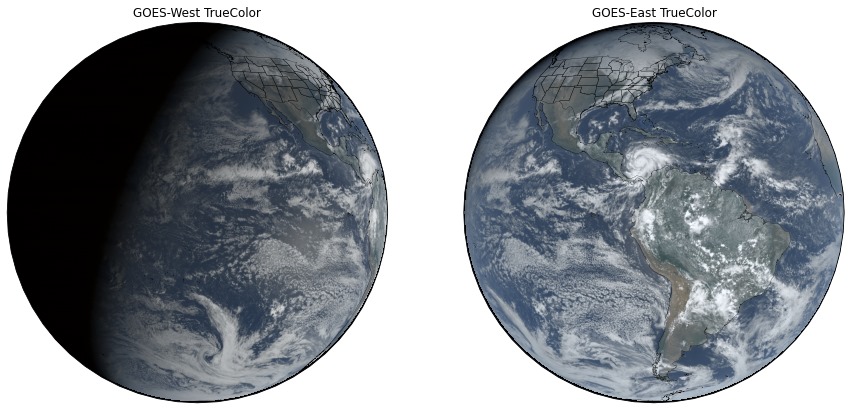
The GOES-R Series satellite’s scientific instruments sense the environment and distribute data to the onboard computer for processing and distribution to the X-Band antenna for transmission to Earth as a digital data stream. The ground system software at Wallops Command and Data Acquisition Station (WCDAS) processes the Level 0 data and creates Level 1b products. For example, the measurements from the ABI are converted to units of radiance and calibrated, navigated, and remapped to a fixed grid. The antenna at WCDAS transmits the products to the GOES-R Series satellite for relay through the satellite’s GOES Rebroadcast (GRB) transponder and L-Band antenna to GRB receive stations, including GRB receive stations at the NOAA Satellite Operations Facility (NSOF).
The GRB provides the primary GOES-16 and GOES-17 relay of full resolution, calibrated, near-real-time direct broadcast Level 1b data from each instrument and Level 2 data from the Geostationary Lightning Mapper (GLM). The GRB is a significant increase in capability from the GOES VARiable (GVAR) service on GOES 13, 14, and 15. The GRB contains the ABI, GLM, space environment, and solar data that drive the data flow in the NOAA space and Earth environment research and operational frameworks.
To receive the GRB signal, a user installs a receive station consisting of an antenna, Low Noise Amplifiers, RF/Intermediate Frequency (IF) downconverter, Digital Video Broadcasting-S2 (DVB-S2) capable receiver and GRB-compatible demodulator, and processing software. The GRB link data rate is 31 Mbps and between 1.5 TB and 2 TB of data are transmitted during a 24-hour period.
The GRB data stream includes the ABI Level 1b products. In Mode 4, or Continuous full disk mode, the ABI produces a full disk image every 5 minutes. In Mode 3, or Flex Mode, the ABI produces a full disk every 15 minutes, a CONUS image (resolution 3000 km by 5000 km) every 5 minutes, and two mesoscale domains (resolution 1000 km by 1000 km) every minute or one domain every 30 seconds if it is set to that scanning rate. All 16 Bands are available. A new mode, Mode 6, is being tested and if approved by NESDIS and NWS then it would provide a full disk image every 10 minutes, CONUS image every five minutes, and images from both mesoscale domains every minute.
GRB to GVAR comparison
| Data | GOES Variable (GVAR) | GOES Rebroadcast (GRB) |
|---|---|---|
| Full Disk Image | Hemispheric view every 30 minutes | 5 mins (Mode 4), 15 mins (Mode 3), and 10 mins (Mode 6) |
| Other Modes | Rapid Scan, Super Rapid Scan | 3000 km X 5000 km (CONUS: 5 minute) 1000 km X 1000 km (Mesoscale: 30 seconds) |
| Polarization | None | Dual Circular Polarized |
| Polarization | None | Dual Circular Polarized |
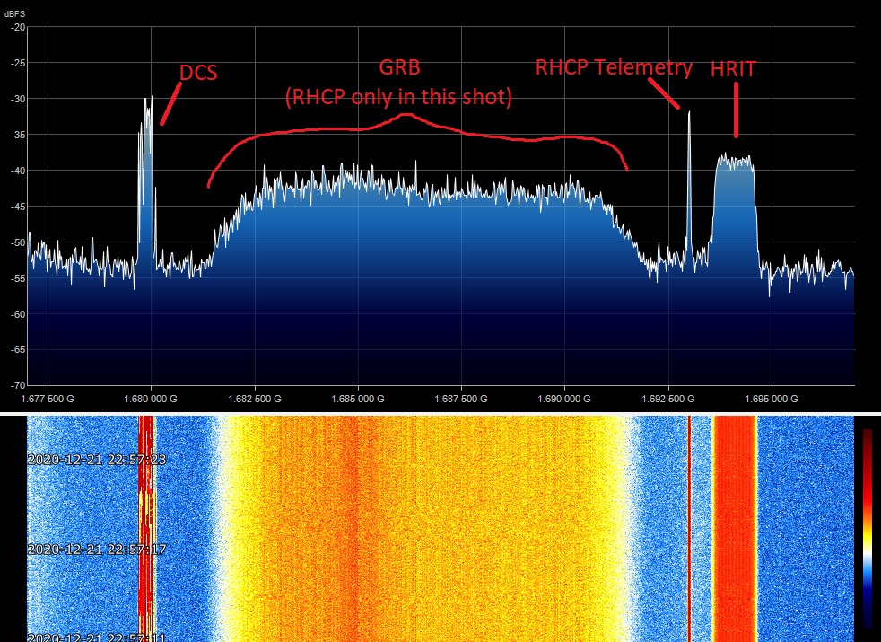
| Receiver Center Freq | 1685.7 MHz (L-Band) | 1681.6 MHz (L-Band) |
| Date Rate | 2.11 Mbps | 31 Mbps |
| Antenna Coverage | Earth Coverage to 50 | Earth Coverage to 5 |
| Data Sources | Imager and Sounder | ABI (16 bands), GLM, SEISS, EXIS, SUVI, MAG |
| Space Weather | None | ~2 Mbps |
| Lightning Data | None | 0.5 Mbps |
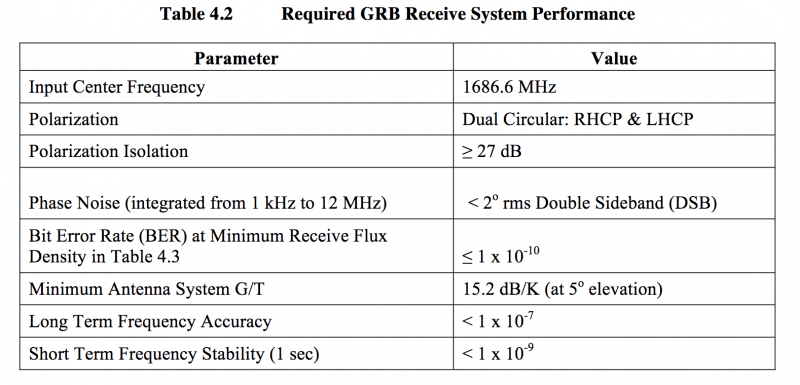
The GRB downlink signal from the satellite is at a center frequency of 1686.600 MHz and requires an antenna gain-to-noise-temperature (G/T) of 15.2 dB/K for worst-case locations. Modulation is either 8PSK with a symbol rate of 7.825768 Million symbols per second (Msps) with a rate 2/3 Forward Error Correction coding or QPSK with a symbol rate of 8.665938 Million symbols per second (Msps) with a rate 9/10 Forward Error Correction coding. However, the GOES-R program designated QPSK the default modulation mode in 2017.
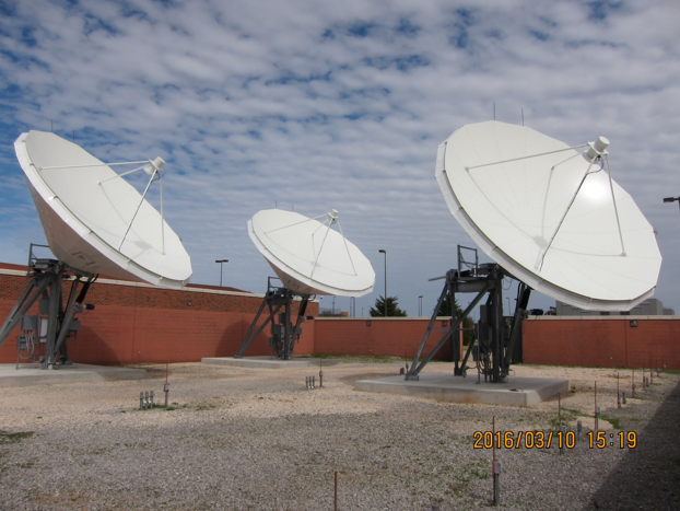
The nominal antenna size: 4.5-meter dish with a system noise temperature of 120 degrees Kelvin. Off-the-shelf DVB-S2 receivers are available to receive the IF outputs from the antenna system for each polarization. The DVB-S2 receiver extracts and outputs CCSDS Channel Access Data Units (CADUs) at a rate of 15.5 Megabits per second (Mbps) from each polarization channel. The dual circular polarization facilitates a data rate of 31 Mbps.
The Product Definition and Users’ Guide (PUG) Volume 4 describes the GRB product content and format and documents the communications and application-level protocols used in the GRB. The PUG Volume 4 lists the products that are on the Left Hand Circular Polarized (LHCP) channel and on the Right Hand Circular Polarized (RHCP). The ABI Level 1b products on the LHCP channel are similar to the products that were available on the legacy GOES Variable (GVAR) DB service provided by GOES-NOP.
For more information go to PUG Volume 4.
GRB users can generate products with software purchased from a vendor, developed by the user, or downloaded from the University of Wisconsin – Madison Space Science and Engineering Center’s (SSEC) Cooperative Institute for Meteorological Satellite Studies (CIMSS). SSEC/CIMSS developed the Community Satellite Processing Package for Geostationary Data (CSPP Geo) software with funds provided by the GOES-R Program Office.
Manufacturers of commercially available GRB Systems
The Rebroadcast (Grb) Downlink Specifications For Users, is available at:
https://www.goes-r.gov/users/docs/GRB_downlink.pdf
GRB uses two digital streams, each at 15.5 Mbps, compared to the GVAR standard of a single 2.11 Mbps stream. A dual-polarization approach is used to accommodate the 31 Mbps data rate within a frequency bandwidth of 9.8 or 10.9 MHz per polarization, using a standard downlink modulation at 1686.6 MHz (L-band). GRB produces a full disk image in either five or fifteen minutes, depending on mode, compared to GVAR’s thirty minutes.
So How can this be done?
You’ll need some more expensive than the HRIT stuff, so be forwarned:
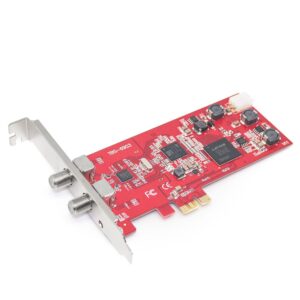
Setup is 2.1M dish with Ed Murashie feed or a home built feed, or a RF Hamdesign septum feed, and GRB box (hybrid combiner and preamp). 2 RG-6 quad shielded cables with 2 Nooelec Sawbird GOES + amplifiers at the feed. The Demodulating card is Digital Devices Cine S2 V7A DVB-S2 satellite card or a NOVRA S400 receiver. Ingestion software is University of Wisconsin’s CSPP-GEO running on 12-core Dell R710 server and finally on a second computer, processing software is the University of Wisconsin’s Geo2grid running on a 20-core Cisco C220 M3 server.
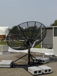
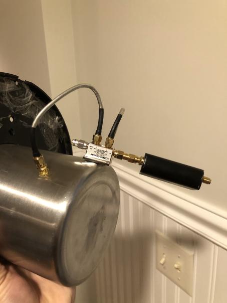
A working GRB feed was built using a thick utensil holder with 2 probes cut for 1686 MHz and 90 degrees apart. Both probes are then connected to the 2 inputs of the hybrid combiner. So by phasing both signals by +90 deg and -90 deg, it outputs 2 cables with RHCP on the first output and LHCP on the second output.
You can test GRB if you already have at least a 5.4 ft dish (1.65m) but the results are not the best. If you have to buy or you are searching for a dish for GRB, go higher in dimension and go at least a 2.1m (6.9 ft) or +. Then you’ll have more margin. If you don’t want to experience signal loss during sun outage period in fall and spring, you would need at least a 3m dish (9.8 ft) A 12 ft (3.6m), would still be better, but I don’t know a single GRB amateur that doesn’t experience a signal loss during peak sun outage.
Prototype Square septum feed for GRB https://www.satelliteguys.us/xen/threads/goes-16-grb-downlink-vs-gvar.371582/page-32
The Open Satellite Project https://osp.teske.net.br/channel/opensateliteproject
There is a fantastic forum thread on Receiving GRB as well https://www.satelliteguys.us/xen/threads/goes-16-grb-downlink-vs-gvar.371582/
RFhamdesigns Septum Feed https://www.rfhamdesign.com/products/dish-feeds/septum-dish-feed/index.php
Possible Replacement for TBS6903 card https://www.digital-devices.eu/shop/en/professional-series/octopus-pcie-series/287/digital-devices-octopusci-s2-pro-advanced-twin-ci-and-twin-dvb-s2-tuner-for-pcie-slot