

HRIT/EMWIN & GRB
What exactly are HRIT/EMWIN and GRB? And why do we get it “second-hand”?
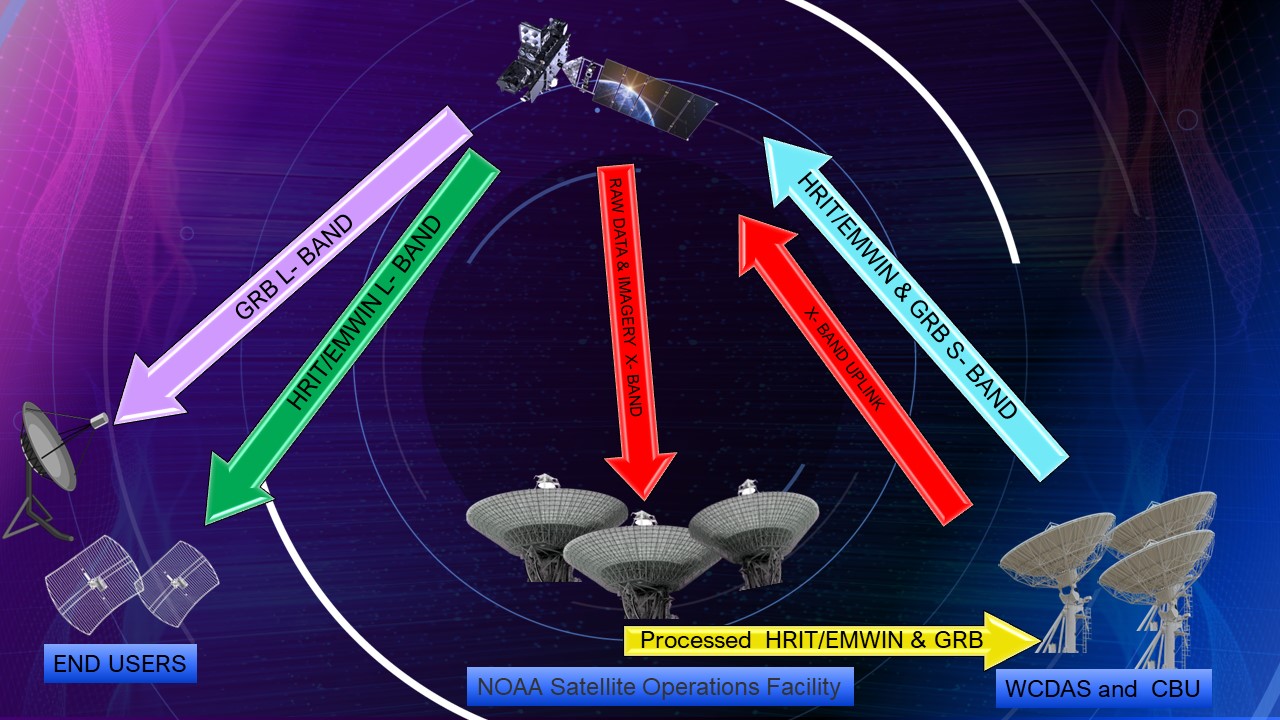
Unlike what you might expect, HRIT/EMWIN and GRB users don’t get raw images captured directly by the satellite. Instead, the satellite transmits re-processed versions of the imagery, which were first processed on the ground, back down to users in the L-Band frequency.
HRIT/EMWIN
The NOAA/NESDIS High Rate Information Transmission / Emergency Managers Weather Information Network (HRIT/EMWIN) broadcast provides a GOES-R Series relay of reduced resolution imagery transformed into the HRIT/LRIT format along with the EMWIN product suite, along with a copy of the GOES Data Collection System (DCS) broadcast, and other hydrological/meteorological information. HRIT/EMWIN is a combined service that replaces the LRIT and EMWIN stand-alone services found on the older GOES 13, 14 and 15.
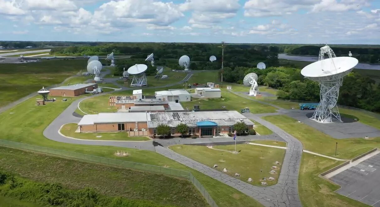
The primary HRIT/EMWIN broadcast is formed in the HRIT/EMWIN processors within the Product Distribution and Access (PDA) system at the NOAA Satellite Operations Facility (NSOF) in Suitland, MD. It is formed into a broadcast stream and sent to either the Command and Data Acquisition Station at Wallops Island, Virginia (WCDAS) or the Consolidated Backup Facility (CBU) at Fairmont, WV for uplink to the satellite. A secondary instance of the HRIT/EMWIN, GRB and PDA systems are located at the Consolidated Backup Facility (CBU) in Fairmont, WV. This broadcast stream can be uplinked at the CBU at Fairmont or transferred to the Wallops Command and Data Acquisition Station (WCDAS) in Wallops Island, Virginia.
The HRIT/EMWIN broadcast and GRB broadcast can be received within the footprint of the GOES East and West satellites. The HRIT/EMWIN broadcast can be received from the Eastern Atlantic Ocean to the West-Central Pacific Ocean. In addition, the HRIT/EMWIN broadcast contains imagery in the NOAA HRIT format from the Himawari satellite(s). This extends the coverage available to the Indian Ocean and East Asia mainland.
In summary, the GOES-R Satellite scans the earth, in many bands, then the ground system receives the Level 0 (L0) raw data from GOES-R transmitted via downlink to Earth as a digital data stream to the NOAA Command and Data Acquisition site, this data is then processed and relayed back to the GOES Satellite Via S- Band and retransmitted by the satellites downlink at 1691.4 MHz L-Band Antenna. An HRIT/EMWIN or GRB user can then receive and decode this transmission.
Ok, but why don’t we get the image directly from the satellite instead of processed imagery?
The raw data that is transmitted by GOES comes on a much higher frequency and with a much higher raw data rate of 75Mbps. This is called Level 0 data*. Level 0 data is the unprocessed instrument data at full resolution, L1b data is the L0 data processed with radiometric and geometric correction applied. L2+ data are derived using environmental variables generated from L1b data along with other ancillary source data, such as NWS. The reason that this has changed since GOES 15 using GVAR (which is basically a raw image) is that NOAA found that most users of GOES data cannot realistically be expected to operate a Large X band antenna and the multitude of processing systems to receive the Level 0 data stream over X band. Nor can the satellite itself process that amount of data reliably. So they rebroadcast it in a format and manner that can be received by almost anyone in the footprint of the satellites.
CHANNELS/DATA/IMAGERY that can be received:
| VCID # | Product Name | GOES-19 Availability | GOES-18 Availability | Period-Min(s) | Format | Resolution |
|---|---|---|---|---|---|---|
| 0 | Admin Text | X | X | 60 | Text Messages | N/A |
| 1 | Mesoscale Imagery | X | X | 15 | HRIT/LRIT | 0.5km Band 2, 2km for bands 7 and 13 |
| 2 | CMI Band 2 | X | X | 30 | HRIT/LRIT | 2 km |
| 7 | CMI Band 7 | X | X | 30 | HRIT/LRIT | 2 km |
| 8 | CMI Band 8 | X | X | 30 | HRIT/LRIT | 2 km |
| 9 | CMI Band 9 | X | X | 30 | HRIT/LRIT | 2 km |
| 13 | CMI Band 13 | X | X | 30 | HRIT/LRIT | 2 km |
| 14 | CMI Band 14 | X | X | 30 | HRIT/LRIT | 2 km |
| 15 | CMI Band 15 | X | X | 30 | HRIT/LRIT | 2 km |
| 16 | G19 CMI Band 13 | X | 180 | HRIT/LRIT | 2 km | |
| 17 | G18 CMI Band 13 | X | X | 180 | HRIT/LRIT | 2 km |
| 20 | EMWIN – Priority | X | X | Variable | Text | N/A |
| 21 | EMWIN – Graphics | X | X | Variable | Graphic (e.g. GIF, JPEG) | N/A |
| 22 | EMWIN – Other | X | X | Variable | Text and Graphic | N/A |
| 24 | NHC Maritime Graphics Products | X | X | 60 | Graphic (e.g. GIF, JPEG) | N/A |
| 25 | GOES-R/S Level II Products | 60-240 | HRIT/LRIT | 2-10 km | ||
| 30 | DCS Admin | X | X | Continuous | Text | N/A |
| 32 | DCS Data New Format | X | X | Continuous | Formatted Text | N/A |
| 60 | Himawari-9 | X | 60 | LRIT | 4 km |
Listing of available “Virtual Channels” as of 5/2025
NOTE: Only Band 13 is relayed from GOES 18 TO GOES 19, Band 13, and Band 13 is relayed from GOES 19 TO GOES 18. Only GOES 18 has relays of VS, IR, and WV from Himawari-9
GRB (Goes ReBroadcast)
The GOES-R Series satellite’s scientific instruments sense the environment and distribute data to the onboard computer for processing and distribution to the X-Band 8220.000 MHz antenna for transmission to Earth as a digital data stream. The ground system software at Wallops Command and Data Acquisition Station (WCDAS) processes the Level 0 data and creates Level 1b products. The 7216.600 MHz antenna at WCDAS transmits the products to the GOES-R Series satellite for relay through the satellite’s GOES Rebroadcast (GRB) transponder and L-Band 1686.600 MHz antenna to GRB receive stations, including GRB receive stations at the NOAA Satellite Operations Facility (NSOF).
Users with A GRB system can then receive and process the rebroadcasted imagery.
GOES-R Series Uplinks and Downlnks detailed diagram:
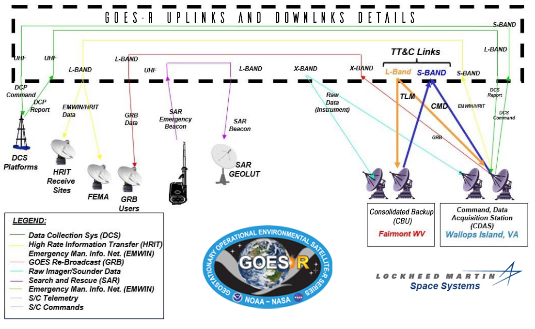
terrestrial means (using Product Dissemination and Access [PDA]) to NSOF (primary) and CBU (backup) for processing into the HRIT format. EMWIN data is folded into the same stream and
then returned over PDA to WCDAS (primary) and uplinked to the spacecraft via S-band and then downlinked via L-band to the user community on the HRIT/EMWIN band. In the backup mode,
CBU combines the data and uplinks the stream in the same way to enlarge
Communications Subsystem
The communications subsystem provides the antennas and transponders used for communicating with the ground system and for data relay services. The spacecraft uses S-band,
L-Band, X-Band and UHF links to provide the command, telemetry (1693.000 MHz), and tracking (2211.040 MHz) functions. It also provides a set of communications services (Unique Payload Services) which: support the Data Collection Platforms; relay High Rate Information Transmission (HRIT) and imaging data between Earth terminals and relays the Emergency Managers Weather Information Network (EMWIN) broadcast on the HRIT/EMWIN; detects and communicates Search and Rescue (SAR) Emergency Locator Transmitter distress signals; and rebroadcasts processed GOES-R sensor data via the GOES Re-broadcast (GRB).
Other Spacecraft Subsystems
Command and Data Handling Subsystem
The command and data handling (C&DH) system includes the hardware needed to process,
route, and deliver commands, telemetry, and instrument data on board the spacecraft, including the processing resources needed for the flight software to function. The C&DH system includes 6 component types, including the on-board computers, command and telemetry processors, remote interface units, sun pointing platform interface electronics, pyro relay assemblies, and a command decryption unit assembly.
Electrical Power Subsystem
The primary function of the electrical power subsystem (EPS) is to provide power to operate the
satellite for 15 years in geostationary orbit. It consists of a Scalable Power Regulation Unit (SPRU) to control the flow of power from the solar arrays and batteries onto the busses, two batteries for energy storage, a solar array for power generation, 70-volt and 28-volt power busses to distribute power to the loads, and two Fuse Board Assemblies to provide load overcurrent protection.
Guidance, Navigation, and Control Subsystem
The guidance, navigation, and control (GN&C) subsystem provide guidance, navigation, and
attitude & articulation control for the GOES-R spacecraft. Inertial Measurement Units (IMU) and
star trackers provide attitude determination, a global positioning system (GPS) receiver provides orbit determination, and attitude control is provided using reaction wheels and the propulsion system. The GN&C subsystem is also responsible for controlling the spacecraft’s gimbals for the X-Band antenna, solar panel, and sun-pointing platform.
Propulsion Subsystem
The propulsion subsystem provides the impulse to perform the thrusting maneuvers required
during each mission phase, from launch and orbit raising through end-of-life maneuvers. It consists of a single liquid apogee engine (LAE), sixteen monopropellant low thrust rocket engine assemblies (REA), eight monopropellant REAs, two hydrazine bi-propellant thrusters, 4 Arcjets, and associated tanks, valves, and regulators.
Thermal Control Subsystem
The thermal control subsystem consists of all spacecraft thermal elements and coatings required to control the onboard temperature of spacecraft elements. The subsystem uses active and passive thermal control techniques and includes finishes, insulators, multi-layer insulation (MLI), heaters, thermostats, and other heater controls, temperature sensors, heat transferring apparatus, radiators, sun shields, and radiation shields to accomplish its function.
Mechanical Subsystem
The Mechanical subsystem provides the mechanical interface and structural support for
spacecraft components as well as the mechanisms that must be stowed and restrained for launch and later deployment. The structure possesses sufficient strength, stiffness, and damping for subsystems and payloads to survive the load conditions that exist within the envelope of the mission as well as test requirements. The mechanisms include hinges, retention, and release (R&R) hardware, motors, gimbals, and dampers. These are used to deploy and point the Solar Wing Subsystem and the antennas.
Footnote on Level 0 Data:
The ABI Level 0 data are composed of Consultative Committee for Space Data Systems (CCSDS) packets containing the science, housekeeping, engineering, and diagnostic telemetry data downlinked from the instrument. The Level 0 data files also contain orbit and attitude/angular rate packets generated by the GOES spacecraft. Each CCSDS packet contains a unique Application Process Identifier (APID) in the primary header that identifies the specific type of packet and is used to support the interpretation of its contents. The ABI Level 0 data are used for specialized data processing activities. The Level 0 CCSDS packets must be uncompressed, extracted, and byte-aligned to create the Level 1a data product. The Level 1b data processing extracts the Level 1a data and performs the radiometric and geometric corrections.
GOES-R Series Program, (2019): NOAA GOES-R Series Advanced Baseline Imager (ABI) Level 0 Data. NOAA CLASS System