Skip to content
USRADIOGUY

USRadioguy.com

Welcome to USRadioguy.com – Unlocking the Potential of Software Defined Radio

  • Home
    • Home of USRadioguy
    • USRadioguy Newsletter
    • Tried and Tested Hardware
    • What is RTL-SDR?
    • Global Weather Data
  • Satellite Reception
    • Geo Stationary Satellites
      • Geo-stationary Satellite Imagery Reception
      • GOESTOOLS on the PI
      • Update Goestools for GOES 18,19
      • Receiving GOES with SatDump CLI Mode
      • GOES receiving in Windows for SatDump GUI
      • Decoding EWS-G1/EWS-G2
      • GOES GRB Reception WIP
      • Optimizing a WIFI Grid Antenna for Maximum Efficiency
    • APT Satellites
      • APT RECEPTION
      • Satdump for Meteor and NOAA decoding
      • METEOR M2- Series
      • WxtoImg Fix
      • Converting to new TLE format
      • Layering Fire and Hotspot Data on Meteor Sat Imagery
      • HRPT Satellite Tracking and Capture
    • Receiving Other Satellites
      • Inmarsat Decoding
      • Receiving the Funcube Amateur Satellite
    • User Maps and Dish Pointers
      • Satellite Dish Pointer
      • User Global Ground Station Maps
      • Usermap rendered with Cesium
      • Global Map of Govt Dish Stations
    • Satellite Details & Information
      • ORBITAL DYNAMICS 101
      • HRIT/EMWIN & GRB Defined
      • Mesoscale Imagery Defined
      • Viterbi, R/S Errors, Packets
      • GOES BAND IMAGERY
      • Stray Light Zone (SLZ)
      • Drifting a geostationary satellite
      • GOES-R Series Multimedia Tour
      • Online Satellite Imagery and Information
      • Satellite Frequencies
      • Solar and Space Weather
  • Satellite Imagery
    • IMAGERY- Current GOES East & West HRIT Satellite Imagery
    • IMAGERY- GOES 16&18 – Past 96 Hours of Imagery
    • High Resolution Imagery
    • Daily 3D view of Earth
    • NOAA APT Satellite imagery
    • PlanetMaker
    • GOES16 A full year of received imagery
  • Imagery Processing
    • Custom Color Lookup Table & Gradients
    • GOES-R Custom Imagery Scripts
    • Global geo-ring composites
    • MODIS VIIRS Global Coverage
    • 3D Satellite Tracking
    • The quest for True Color Imagery
    • 3D animation of realtime data
    • Layering Geo-Spatial Fire Data into Satellite Imagery
    • Orbital dynamics and the Moon
    • National Hurricane Data
  • News, VLOGS & BLOGS
    • News & USRadioguy Blogs
    • USRadioguy VLOGS
  • Project Lab
    • Orbital Information and Visualizations
      • Enhanced Planet Earth
      • Satellites in Orbit
      • Solar System
      • Objects in Orbit
    • Current Station Weather
      • Current Groundstation Weather
      • Global Weather Data
      • Space Weather
    • WWII RADIO
      • WWII K-24 Aerial Camera
      • WWII RADIO
      • RADIO SET SCR-284
      • VS-3 VIBRATOR CONVERSION
      • VIBRATOR CONVERSION MODULE
      • BD-71 Field Switch Board and EE-8B Field Telephones
      • R-100/URR 1944 MORALE RADIO
      • A PORTABLE WWII ERA “MORALE RADIO”
      • AN/GRR-5 THE ANGRY 5
      • WWII Audio Page
    • Raspberry Pi Projects
      • ADS-B Reception
      • Allsky Camera
      • Pi Based Picture Frame
      • PI Based Broadcastify Server
      • Solar Power for PI
    • Hubble Space Telescope Data Processing
    • Zombie Satellites
    • DRONES
  • About Me
    • About Usradioguy
      • SETEC Astronomy
    • Tried and Tested Hardware
    • Rare Captures
    • My Other Interests
    • Presentations
    • Merchandise
    • Privacy Policy
  • Home
  • Decoding EWS-G1 or GOES-13

Decoding EWS-G1 or GOES-13

Decoding EWS-G1 (GOES13)

Europe, North Africa, and the Mediterranean Sea from Zbigniew Sztanga’s receiver.

UPDATE 1/15/2021 from Zbigniew Sztanga @ZSztanga
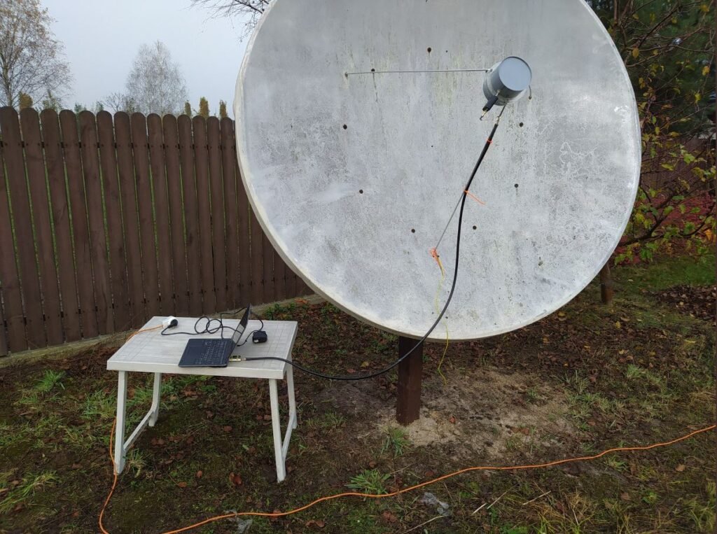
Now with my EWS-G1 station running (at least on my end, still some work on servers), I might explain how exactly it works because it is quite more complex than a “normal” GOES station. The first (I think the biggest) difference is that the station is not contained to just a pi. The station is running on 3 units in total: Pi for SDR, PC (could be called a server really) for demodulation, decoding, processing, and uploading, a server (in France, making the whole system “international”) hosting web interface and storing images (we are talking about 500MB images every hour here).

Here is how it all works:

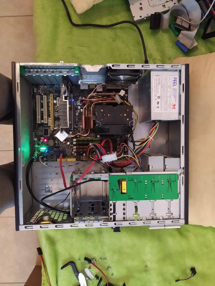
Our first element is a pi 4B 4Gb ram. This device doesn’t perform any demodulation/decoding. All it is doing is running SoapySDR Remote Server. It allows me to access my SDR (Airspy mini in this case) from the PC. I will probably throw FY-2H on that pi too because I have a few spare SDR’s I could use.

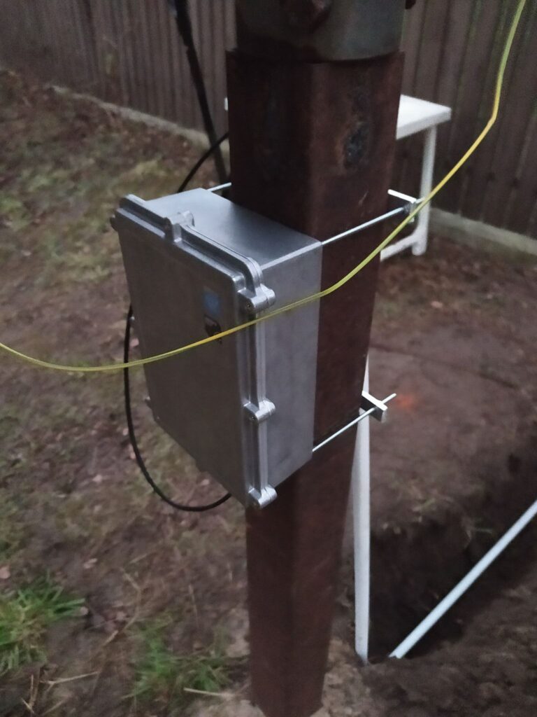
Our next element in the chain is the first server. It is in the same local network and it is the brain of the whole station. It is running the most basic system I could get on it, in this case, Debian 10 with no graphical interface. It is accessing the SDR through Soapy Remote (from the pi) and running the Ingestor. So far it has been running for a whole night and it seems to work fine.

The last step is the main server. It is located in France (quite far from there) and it will be hosting all the images and web services. (Note the “will” as it is still not finished.) All the images will be uploaded into it because there isn’t much space on the other 2 devices.

Received by Zbigniew Sztanga 11/11/2020

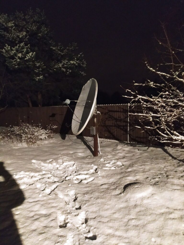
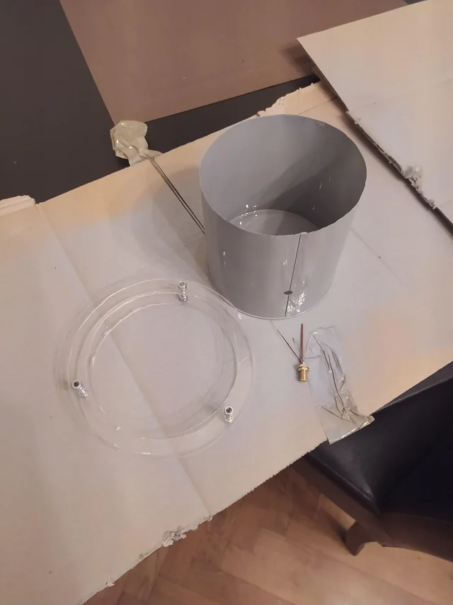
Here are some photos of the setup, including the first server, the Pi and the dish.

Photo courtesy @ZSztanga

UPDATE 09-22-202 @Aang254 NEW RELEASE OF SATDUMP!
It is designed to be user-friendly, with a GUI input, and best of all, can decode many different satellites! This software is still being developed, so bugs and potential instabilities are to be expected. The program can either run as a 24/7 service for automated station setups or as a standalone “one-time” decoder, there are releases for Debian-based system, and a Windows based system.
Decoder and Documentation can be found on his GitHub page at https://github.com/altillimity/SatDump

UPDATE 11/19/2020
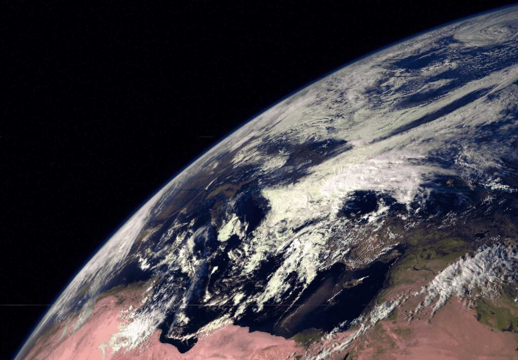
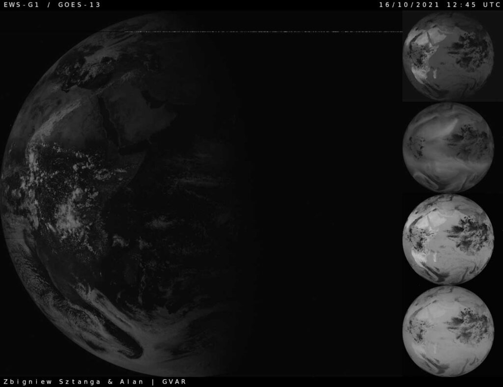
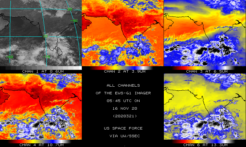
EWS-G1 Imagery is now available for public use! This provides coverage over an area that was not easy (or free) to obtain. EWS-G1 sends a full disk every thirty minutes, with one visible band and 4 IR bands.
SSEC has enabled the US Space Force imagery from EWS-G1 and added it to the product list https://www.ssec.wisc.edu/data/geo/…

What you need to know about EWS-G1 – GOES-13

EWS-G1 (Electro-optical Infrared Weather System Geostationary) is a weather satellite of the U.S. Space Force, formerly GOES-13 (also known as GOES-N before becoming operational) and part of the National Oceanic and Atmospheric Administration’s Geostationary Operational Environmental Satellite system. On 14 April 2010, GOES-13 became the operational weather satellite for GOES-East. It was replaced by GOES-16 on 18 December 2017 and on 8 January 2018 its instruments were shut off and it began its three-week fuel-conserving drift to an on-orbit storage location at 60° West longitude, arriving on 31 January 2018. It remained there as a backup satellite in case one of the operational GOES satellites had a problem until early July 2019, when it started to drift westward and was transferred to the U.S. Air Force, and then the U.S. Space Force.

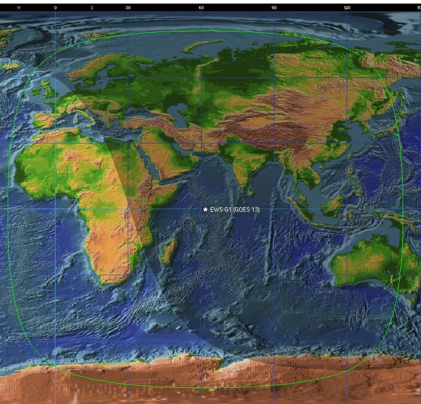
  • GOES-13 arrived at 61.5° East longitude in mid-February 2020. The satellite is renamed EWS-G1 and fully operational for the Indian Ocean since September 8, 2020.
  • GOES-13 (EWS-G1) only transmits SD (Sensor Data) and GVAR (GOES VARiable), it DOES NOT transmit LRIT.
  • Working frequencies are: SD 1676 MHz and GVAR 1685.7MHz
  • The broadcast is also extremely weak when compared to LRIT/HRIT, and thus requires a significantly higher gain dish antenna. The smallest confirmed receiving dish is 180cm, with the satellite 20° above the horizon.
  • GVAR and SD are about 5MHz wide, so an SDR capable of that bandwidth is required. (RTL-SDR is not)-the Nooelec GOES bundle IS NOT CAPABLE of receiving GOES-13.
  • The software is in the early stages of development, and not publically available yet. You can expect the first releases soon. I will post information as it becomes available.
EWS-G1 GOES-13 Coverage

SPACE OPERATIONS COMMAND (SPOC) information on EWS-G1 https://www.spoc.spaceforce.mil/About-Us/Fact-Sheets/Display/Article/3298455/eoir-weather-system-geostationary-ews-g1


There are some very smart folks working on this, and thanks are to be given to those doing the groundwork and sharing their knowledge with the rest of us!

@ZSztanga’s GOES-13 Reception Setup, with 1.8m dish.

The EWS-G1 is a temporary fix to fill a gap in coverage until the Space Force acquires a new system that will likely be a distributed or proliferated low-Earth orbit constellation. EWS-G1 has a projected end of service date of January 2024. (possibly longer).

EWS-G1 will be replaced at some point by the currently being built Electro-Optical/Infrared Weather System (EO/IR EWS) program, and if still functional, will be placed into orbital storage along with GOES-15, Contracts totaling $309 million to three companies were signed in June of 2020 to fastrack the EWS-G1 replacements. It is on track for a 2023 launch. The contract awarded in November 2018 to Ball Aerospace is for one low earth orbit satellite but there are options in the contract to get a second satellite.


Links to EWS-G1 Decoding software and Hardware:

SatDump

GVAR Ingestor

Hardware Humor Imagery Processing Interesting stuff you should know! Launch News Life News Product Review Satellites Science Software Space Weather Uncategorized VLOG

Satellite And Weather Related Feeds

  • CIMSS Satellite Blog
  • USRadioguy.com
  • wildfires
  • NASA Earth Observatory
  • SPC Particularly Dangerous Situation (PDS) Tornado/Severe Thunderstorm Watch
  • satellites
  • Satellites News -- ScienceDaily
  • Satellite Liaison Blog
Wildfire in Ontario produces a large pyrocumulonimbus cloud
American Samoa’s Wettest Year Gets Wetter
Deadly flash flooding in Ruidoso, New Mexico
Global cloud layers on your Devices
End Of Life for NOAA 15 and 19?….not so fast…
Vitality GOES
Vitality GOES
The fire cycle
Unmasking the complicated chemistry of wildfire smoke: What's in it?
NOAA unveils powerful convergence of AI and science with revolutionary Next-Generation Fire System technology
The Salty Lake of Gas Hure
Greenland’s Bejeweled Ice Sheet
Manitoba Burning
Manitoba Burning
SPC PDS Severe Thunderstorm Watch 399
Five historically huge solar events
65 years since the world’s first weather satellite
Investing in America: NOAA's Science, Service and Stewardship in Action
Earth’s weather satellites just spent 10 years watching Venus — here’s what they found
Record-breaking 10-billion-year radio halo just rewrote the universe’s origin story
Massive thread of hot gas found linking galaxies — and it’s 10 times the mass of the Milky Way
The Need for Speed: OCTANE Cloud-Top Winds at SPC
Summer Storms, Flooding Target Mid-Atlantic
Southwest Thunderstorms – Late June 2025
  • Facebook Geo Stationary Satellites
  • Usradioguy Facebook
  • Instagram
  • Reddit
  • Github
  • Linkedin

Copyright © 2025 USRadioguy.com - All Rights Reserved. All material protected by Fair Use Section 107 of the Copyright Act. This site is Verified and Secured with 256 bit SSL encryption