Skip to content
USRADIOGUY

USRadioguy.com

Welcome to USRadioguy.com – Unlocking the Potential of Software Defined Radio

  • Home
    • Home of USRadioguy
    • USRadioguy Newsletter
    • Tried and Tested Hardware
    • What is RTL-SDR?
    • Global Weather Data
  • Satellite Reception
    • Geo Stationary Satellites
      • Geo-stationary Satellite Imagery Reception
      • GOESTOOLS on the PI
      • Update Goestools for GOES 18,19
      • Receiving GOES with SatDump CLI Mode
      • GOES receiving in Windows for SatDump GUI
      • Decoding EWS-G1/EWS-G2
      • GOES GRB Reception WIP
      • Optimizing a WIFI Grid Antenna for Maximum Efficiency
    • APT Satellites
      • APT RECEPTION
      • Satdump for Meteor and NOAA decoding
      • METEOR M2- Series
      • WxtoImg Fix
      • Converting to new TLE format
      • Layering Fire and Hotspot Data on Meteor Sat Imagery
      • HRPT Satellite Tracking and Capture
    • Receiving Other Satellites
      • Inmarsat Decoding
      • Receiving the Funcube Amateur Satellite
    • User Maps and Dish Pointers
      • Satellite Dish Pointer
      • User Global Ground Station Maps
      • Usermap rendered with Cesium
      • Global Map of Govt Dish Stations
    • Satellite Details & Information
      • ORBITAL DYNAMICS 101
      • HRIT/EMWIN & GRB Defined
      • Mesoscale Imagery Defined
      • Viterbi, R/S Errors, Packets
      • GOES BAND IMAGERY
      • Stray Light Zone (SLZ)
      • Drifting a geostationary satellite
      • GOES-R Series Multimedia Tour
      • Online Satellite Imagery and Information
      • Satellite Frequencies
      • Solar and Space Weather
  • Satellite Imagery
    • IMAGERY- Current GOES East & West HRIT Satellite Imagery
    • IMAGERY- GOES 16&18 – Past 96 Hours of Imagery
    • High Resolution Imagery
    • Daily 3D view of Earth
    • NOAA APT Satellite imagery
    • PlanetMaker
    • GOES16 A full year of received imagery
  • Imagery Processing
    • Custom Color Lookup Table & Gradients
    • GOES-R Custom Imagery Scripts
    • Global geo-ring composites
    • MODIS VIIRS Global Coverage
    • 3D Satellite Tracking
    • The quest for True Color Imagery
    • 3D animation of realtime data
    • Layering Geo-Spatial Fire Data into Satellite Imagery
    • Orbital dynamics and the Moon
    • National Hurricane Data
  • News, VLOGS & BLOGS
    • News & USRadioguy Blogs
    • USRadioguy VLOGS
  • Project Lab
    • Orbital Information and Visualizations
      • Enhanced Planet Earth
      • Satellites in Orbit
      • Solar System
      • Objects in Orbit
    • Current Station Weather
      • Current Groundstation Weather
      • Global Weather Data
      • Space Weather
    • WWII RADIO
      • WWII K-24 Aerial Camera
      • WWII RADIO
      • RADIO SET SCR-284
      • VS-3 VIBRATOR CONVERSION
      • VIBRATOR CONVERSION MODULE
      • BD-71 Field Switch Board and EE-8B Field Telephones
      • R-100/URR 1944 MORALE RADIO
      • A PORTABLE WWII ERA “MORALE RADIO”
      • AN/GRR-5 THE ANGRY 5
      • WWII Audio Page
    • Raspberry Pi Projects
      • ADS-B Reception
      • Allsky Camera
      • Pi Based Picture Frame
      • PI Based Broadcastify Server
      • Solar Power for PI
    • Hubble Space Telescope Data Processing
    • Zombie Satellites
    • DRONES
  • About Me
    • About Usradioguy
      • SETEC Astronomy
    • Tried and Tested Hardware
    • Rare Captures
    • My Other Interests
    • Presentations
    • Merchandise
    • Privacy Policy
  • Home
  • Hubble Space Telescope Data Processing

Hubble Space Telescope Data Processing

“Our species needs, and deserves, a citizenry with minds wide awake and a basic understanding of how the world works.“
~ Carl Sagan

Did you know that anyone can get raw data from the Hubble space telescope? You won’t need any complicated dish set up, or shuttle repair missions, just a PC and the free software below:

  1. Get Raw Hubble Data and FITS Liberator software
    a. Download the ESA/ESO/NASA FITS Liberator 3.0.1
    b. Install the FITS software
  2. Now, go get some Hubble space telescope data here http://hla.stsci.edu/hlaview.html

When you go to the site, you’ll have to search for some data. I chose M101. The Pinwheel Galaxy (also known as Messier 101, M101 or NGC 5457) is a face-on spiral galaxy distanced 21 million light-years (six megaparsecs) away from Earth in the constellation Ursa.

3. Add the FITS data you want to the cart, go up to the cart, and click it and download the zip file to you PC and extract it.

4. Run Fits and navigate to the folder you extracted the data from and open it in FITS

5. Voila!

FITS, showing the Spiral Galaxy M101

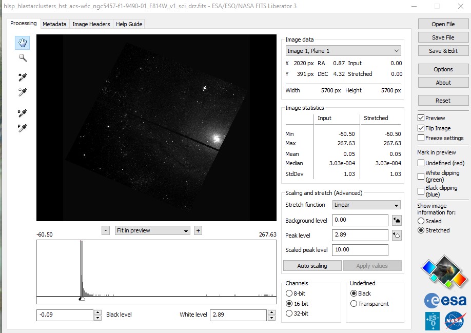
6. What? wait a minute, I was expecting this:

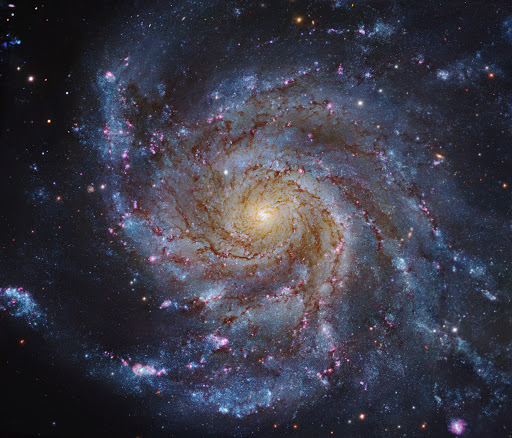
7. Alas Hubble does not composite it’s different channels of color, BUT you can do it yourself with photoshop following this guide: How to Process Data From the Hubble Legacy Archive

Good Luck!

How is Hubble’s data transmitted?
Hubble’s data is transmitted via radio signal (away from Earth) to a geosynchronous Tracking and Data Relay Satellite System (TDRSS) which then rebroadcasts it encrypted to the White Sands Test Facility in New Mexico, then it is retransmitted over secure data lines from the Goddard facility where the raw data is checked and then passed to the Space Telescope Science Institute.

Hardware Humor Imagery Processing Interesting stuff you should know! Launch News Life News Product Review Satellites Science Software Space Weather Uncategorized VLOG

Satellite And Weather Related Feeds

  • CIMSS Satellite Blog
  • USRadioguy.com
  • wildfires
  • NASA Earth Observatory
  • SPC Particularly Dangerous Situation (PDS) Tornado/Severe Thunderstorm Watch
  • satellites
  • Satellites News -- ScienceDaily
  • Satellite Liaison Blog
Trout Fire in New Mexico produces a pyrocumulonimbus cloud
Blowing dust in Argentina
Canadian wildfire smoke over Alaska
End Of Life for NOAA 15 and 19?….not so fast…
Vitality GOES
Vitality GOES
Decommissioning NOAA-18
The fire cycle
Unmasking the complicated chemistry of wildfire smoke: What's in it?
NOAA unveils powerful convergence of AI and science with revolutionary Next-Generation Fire System technology
Earth’s Clouds on the Move
Seasonal Breakup in the Amundsen Gulf
Egypt’s Mediterranean Coast
SPC PDS Severe Thunderstorm Watch 399
Five historically huge solar events
65 years since the world’s first weather satellite
Investing in America: NOAA's Science, Service and Stewardship in Action
Satellite measures CO2 and NO2 simultaneously from power plant emissions for the first time
Existing international law can help secure peace and security in outer space
Small, faint and 'unexpected in a lot of different ways': Astronomers make galactic discovery
Late-Season Atlantic Hurricane-Force Low
Atmospheric River Strikes Eastern U.S.
Another Week, Another Deep South Soaker
  • Facebook Geo Stationary Satellites
  • Usradioguy Facebook
  • Instagram
  • Reddit
  • Github
  • Linkedin

Copyright © 2025 USRadioguy.com - All Rights Reserved. All material protected by Fair Use Section 107 of the Copyright Act. This site is Verified and Secured with 256 bit SSL encryption