
Online Satellite Imagery and Information
“We live in a society absolutely dependent on science and technology and yet have cleverly arranged things so that almost no one understands science and technology.
That’s a clear prescription for disaster.”
Carl Sagan
Online Satellite Imagery and Information
- RealEarth™ is a data discovery and visualization platform developed at SSEC/CIMSS at the University of Wisconsin-Madison to support the outreach and collaboration efforts of scientists.
- Beginner’s Guide to GOES-R Series Data How to acquire, analyze, and visualize GOES-R Series data.
- GOES-R SERIES DOCUMENTS – The GOES-R series Documents and PUGS
- The Geostationary Weather Satellite Group on Facebook.
- Stuff in Space A Graphical Representation of the stuff in orbit.
- Celestrack Cesium A graphical tracking page.
- WxSatS A very cool view from a weather satellite perspective.
- SatNOGS Network
- POES Operational Status – POES Status – OSPO
- SOLARHAM.com | Solar Cycle 25 | Space Weather Website
- ForWarn II is a US Forest Service satellite-mapping tool if you’re interested in tracking vegetation changes caused by wildfires, flooding, tornados, severe weather, insects, diseases, and human-induced disturbances.
- GOES Imagery Viewer – NOAA / NESDIS / STAR
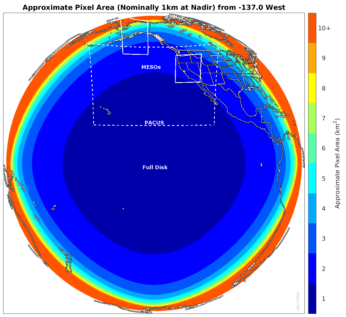
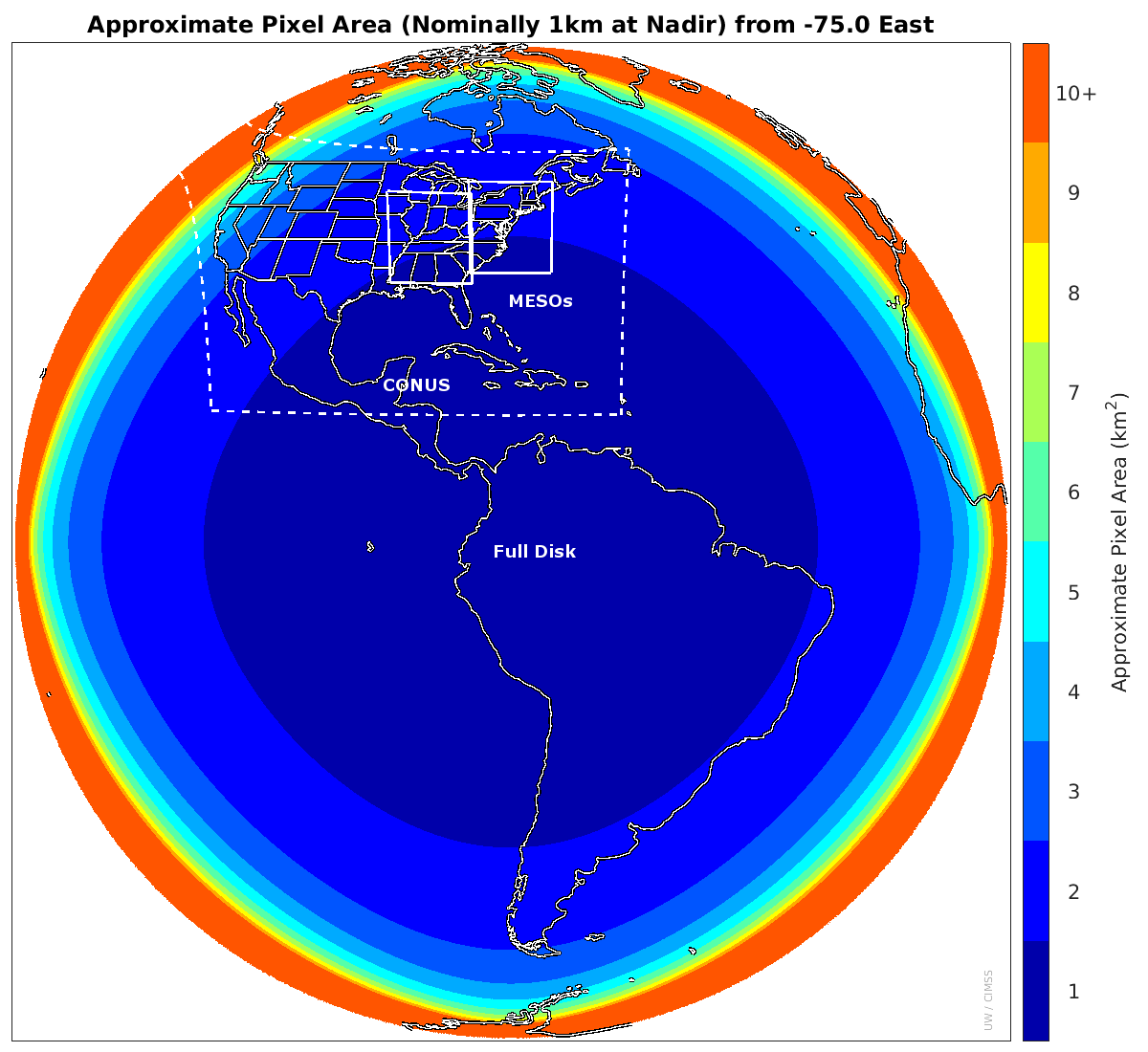
- ABI Meso-scale location search function from the SSEC Data center for GOES-East and -West over their operational lifetimes.
- GOES Data – A big list by SSEC/CIMSS. The GOTO for all things GOES by the University of Wisconsin – Advanced Satellite Products Branch (ASPB) ~ The Birthplace of Satellite Meteorology ~This site has A LOT of information, data, imagery, etc. Including a section on free software for image manipulation, data analysis, phone apps, and more!
- GOES HRIT Schedules (this is what you can download off your dish.
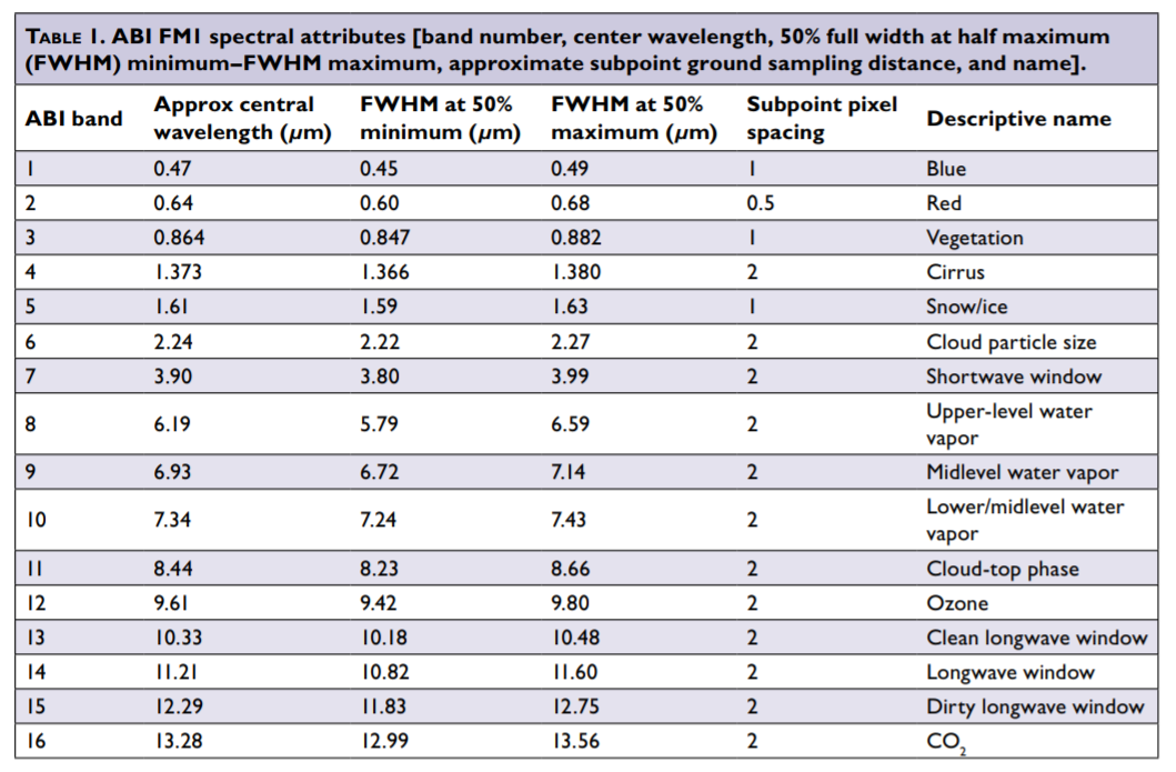
- GOES-16 Band Reference Guide (PDF) So, what is Band 15, and why is it ‘Dirty’?
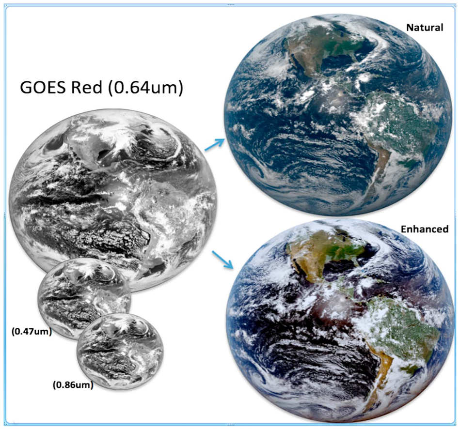
- ABI BANDS QUICK INFORMATION GUIDES These include two visible channels, four near-infrared channels, and ten infrared channels. Each fact sheet covers what the band measures and how this is operationally relevant. The fact sheets also include links for more information.
- GOES GRB Schedules (you’ll need a bigger dish!)
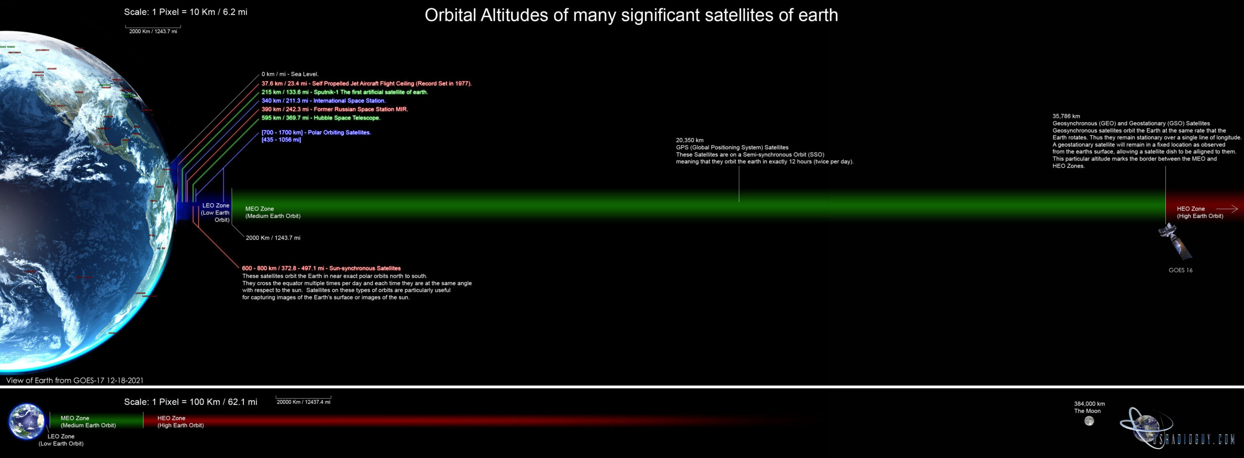
The geostationary orbit is located at an altitude of 35,786 km (22,236 mi) above the Earth’s equator and rotates in sync with the Earth’s rotation.
- The equation to calculate the radius of a geostationary orbit is: R = (GM/ω^2)^(1/3) Where:
- R = radius of the geostationary orbit (km)
- G = gravitational constant (6.673 x 10^-11 m^3 kg^-1 s^-2)
- M = mass of the Earth (5.972 x 10^24 kg)
- ω = angular velocity of the Earth (7.292 x 10^-5 radian/sec)
User Groups and Forums
- Geo-Stationary Facebook Satellite Group https://www.facebook.com/groups/gswsg Facebook Group for Geo-Stationary Weather Satellites
- GOESTools Users https://groups.google.com/g/goestools-users A smaller group for people who use the software Goestools
- GEO-Subscribers https://groups.io/g/GEO-Subscribers The official group is for subscribers of the Group for Earth Observation (GEO)
- Amateur Satellite Group on Reddit https://www.reddit.com/r/amateursatellites/ A subreddit dedicated to artificial satellites
Tools for finding satellite positions.
- Online Dish Pointer, Usradioguy
- Satellite Look Angle Calculator
- Dishpointer
- https://www.n2yo.com/
- Heavens Above
- Celestrack.com
Open Source Software
- Goestools https://github.com/pietern/goestools Tools to work with signals and files from GOES satellites.
- SATDUMP https://github.com/SatDump/SatDump A multi-satellite decoder and image processor.
- GK-2A Decoder https://github.com/sam210723/xrit-rx LRIT/HRIT Downlink Processor for GK-2A
- Sanchez https://github.com/nullpainter/sanchez Designed for processing of greyscale IR images from geostationary satellites, can also be used to reproject full-color images.
- Vitality GOES https://github.com/JVital2013/vitality-goes A Web App for showcasing Geostationary Weather Satellite Data.
- Raydel XRIT Decoder http://www.geo-web.org.uk/XRITDecoder.php A software solution for decoding and extracting files from GOES LRIT/HRIT stream,
- CSPP Geo software https://cimss.ssec.wisc.edu/csppgeo/ Community Satellite Processing Package for Geostationary Data
- Geo2Grid Software Package
- XRIT Decoder Open Satellite Project https://github.com/opensatelliteproject/xritdemod
- Xplanet
- Grafana
- McIDAS-V (UW Madison)
- SIFT–Satellite Information Familiarization Tool (UW Madison) More info
- Python notebook displaying ABI data from @blaylockbk
- SSEC’s HYDRA (use single or multi band CMIP files) Most recent version of the code
- GOES-16 Manipulation Tools from GNC-A
- Manipulating GOES-16 with GDAL from the OCC
- NCview a netCDF visual (quicklook) browser
- Integrated Data Viewer (IDV) (UNIDATA)
- Panoply from NASA Goddard.
- Pytroll GOES-16 ABI: Example
- ImageJ image manipulation.
- Software for Manipulating/Displaying NetCDF Data list from UNIDATA.
- Weather and Climate Toolkit (WCT) from NOAA/NCEI.
- Beginner’s Guide to GOES-R Series Data Resources compiled by Danielle Losos, GOES-R Product Readiness and Operations
- Google Earth Engine: CIMSS “True” Color multi-band example (2 km) and Level 2 Fire/Hot Spot Characterization by D. Losos and K. Schwehr.
Commercial Software
- XRIT Decoder for GOES https://usa-satcom.com/ XRIT Decoder (HRIT from GOES on L-Band), XView, WX Sandwich Maker
- GRB Play https://usa-satcom.com/ Processes NetCDF files for GOES GRB , does animations, Electron and X-Ray flux as well.
- SUVI Play https://usa-satcom.com/ Displays and does animations with CSPP GEO images from GOES GRB
- GRB Streamer and Imager– Bret Casebolt
GOES-16/17 ABI Info
- GOES-R Program the GOES-R Series Data Book and the GOES-R Series Book, including space wx (Elsevier)
- GOES-R Docs F&PS, ATBDs, PUGs, etc. ABI File name conventions
- NESDIS home page and the Product Quality overview page.
- GOES-R/16 tweets and GOES-S/17 tweets
- Pre-launch BAMS article on the ABI including ABI Band Table and ABI Guide
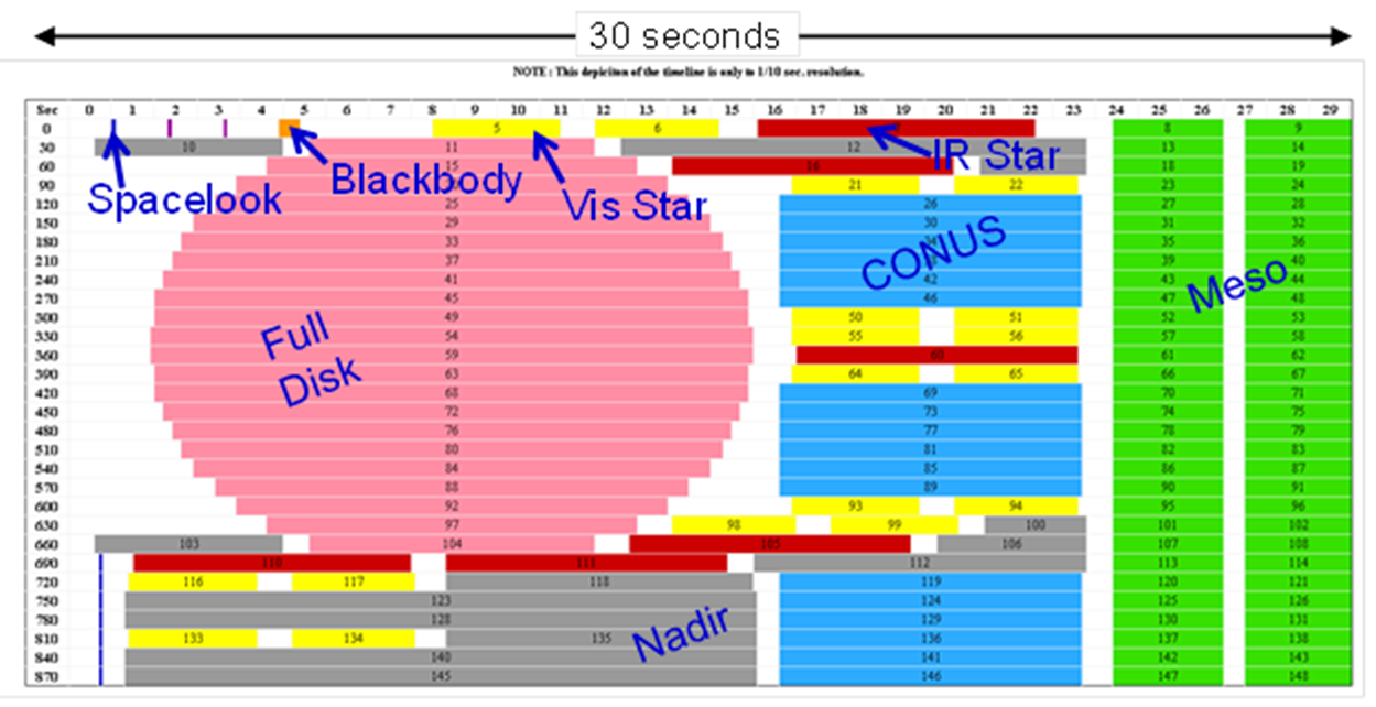
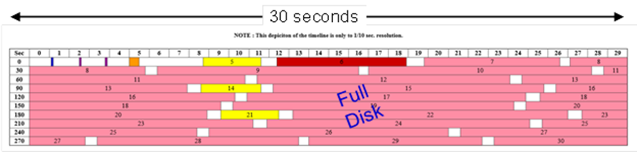
- ABI Mode 3 “cooling” timeline (G-17 only certain times) Mode Mode 3 (flex) Mode 4 (CFD) GOES-16 Mode 6a (w 10-min FD) GOES-17 Mode 6m (w 10-min FD)
- Post-launch NWA JOM article on the ABI including ABI Band Table
- Photons to Pixels article on the ABI
- Generation of GOES-16 True Color Imagery without a Green Band in AGU’s Earth and Space Science, including this figure
- GOES-R Series Publications List
- Recent / Planned ABI Meso-scale locations GOES Contacts e.g., email: SPSD.UserServices@noaa.gov and the meso-sector reposition priority list. NCO.
- ABI Meso-scale locations over the last year and more from the SSEC Data center the last year and more for GOES-East
- ABI Meso-scale location search function from the SSEC Data center for GOES-East and -West over their operational lifetimes
- GOES-East and GOES-West Meso-scale preview location tool from CIRA; Default coverage/pixel size plots, West and East from CIMSS
- Special Bulletins/ General Messages regarding NOAA’s satellite operations.
- GRB ABI Schedules and HRIT ABI Schedules from NOAA’s satellite operations and contacts and Mesoscale Research Request form
- How to DIY and aquire HRIT and other signals by @carlreinemann
- SSEC ABI Monitoring page
- Big Ten Network on Geo Wx Satellites and 2017 Wednesday Nite at the Lab seminar on GOES-16
- Top 25 ABI Animations from GOES-16 and Top 25 ABI Animations from GOES-17
- Beginner’s Guide to GOES-R Series Data Resources compiled by Danielle Losos, GOES-R Product Readiness and Operations
Recommended Hardware Suppliers
Space Weather
- USRadioguys Space Weather Page
- GOES-R Series Space Weather Data
- GOES-16 SUVI imagery from the Space Weather Prediction Center (SWPC).
- GOES-16 SUVI imagery from a DIY GRB receiving system by @wxstar3000 and @H_Neil and a RGB maker Art and Science together!
- GOES-16 SUVI First Light RGB-maker small and large.
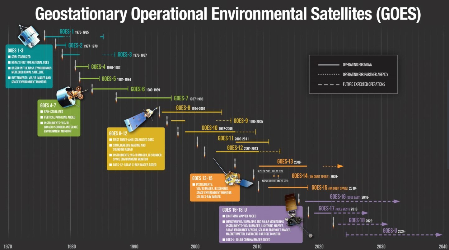
History of GOES satellites
GOES-R Model, built from Paper!

Over on AXM PAPER SPACE SCALE MODELS BLOG, they have a downloadable, printable model of the ATLAS V GOES-R EELV ROCKET and GOES-R PAPER MODEL. The Model of GOES-R is 1:35 scale, designed by Zach from Zach’s PaperSat Designs. The two pdf’s need are below: