Skip to content
USRADIOGUY

USRadioguy.com

Welcome to USRadioguy.com – Unlocking the Potential of Software Defined Radio

  • Home
    • Home of USRadioguy
    • Tried and Tested Hardware
    • USRadioguy Newsletter
    • What is RTL-SDR?
    • Global Weather Data
  • Satellite Reception
    • Geo Stationary Satellites
      • Geo-stationary Satellite Imagery Reception
      • GOESTOOLS on the PI
      • Update Goestools for GOES 18,19
      • Receiving GOES with SatDump CLI Mode
      • GOES receiving in Windows for SatDump GUI
      • Decoding EWS-G1/EWS-G2
      • GOES GRB Reception WIP
      • Optimizing a WIFI Grid Antenna for Maximum Efficiency
    • APT Satellites
      • APT RECEPTION
      • Satdump for Meteor and NOAA decoding
      • METEOR M2- Series
      • WxtoImg Fix
      • Converting to new TLE format
      • Layering Fire and Hotspot Data on Meteor Sat Imagery
      • HRPT Satellite Tracking and Capture
    • Receiving Other Satellites
      • Inmarsat Decoding
      • Receiving the Funcube Amateur Satellite
    • User Maps and Dish Pointers
      • Satellite Dish Pointer
      • User Global Ground Station Maps
      • Usermap rendered with Cesium
      • Global Map of Govt Dish Stations
    • Satellite Details & Information
      • ORBITAL DYNAMICS 101
      • HRIT/EMWIN & GRB Defined
      • Mesoscale Imagery Defined
      • Viterbi, R/S Errors, Packets
      • GOES BAND IMAGERY
      • Stray Light Zone (SLZ)
      • Drifting a geostationary satellite
      • GOES-R Series Multimedia Tour
      • Online Satellite Imagery and Information
      • Satellite Frequencies
      • Solar and Space Weather
  • Satellite Imagery
    • IMAGERY- Current GOES East & West HRIT Satellite Imagery
    • IMAGERY- GOES 16&18 – Past 96 Hours of Imagery
    • High Resolution Imagery
    • Daily 3D view of Earth
    • PlanetMaker
    • GOES16 A full year of received imagery
  • Imagery Processing
    • Custom Color Lookup Table & Gradients
    • GOES-R Custom Imagery Scripts
    • Global geo-ring composites
    • MODIS VIIRS Global Coverage
    • 3D Satellite Tracking
    • The quest for True Color Imagery
    • 3D animation of realtime data
    • Layering Geo-Spatial Fire Data into Satellite Imagery
    • Orbital dynamics and the Moon
    • National Hurricane Data
  • News, VLOGS & BLOGS
    • News & USRadioguy Blogs
    • USRadioguy VLOGS
  • Project Lab
    • Orbital Information and Visualizations
      • Enhanced Planet Earth
      • Satellites in Orbit
      • Solar System
      • Objects in Orbit
    • Current Station Weather
      • Current Groundstation Weather
      • Global Weather Data
      • Space Weather
    • WWII RADIO
      • WWII K-24 Aerial Camera
      • WWII RADIO
      • RADIO SET SCR-284
      • VS-3 VIBRATOR CONVERSION
      • VIBRATOR CONVERSION MODULE
      • BD-71 Field Switch Board and EE-8B Field Telephones
      • R-100/URR 1944 MORALE RADIO
      • A PORTABLE WWII ERA “MORALE RADIO”
      • AN/GRR-5 THE ANGRY 5
      • WWII Audio Page
    • Raspberry Pi Projects
      • ADS-B Reception
      • Allsky Camera
      • Pi Based Picture Frame
      • PI Based Broadcastify Server
      • Solar Power for PI
    • Your very Own Weather Satellite
    • Hubble Space Telescope Data Processing
    • Zombie Satellites
    • DRONES
  • About Me
    • About Usradioguy
      • SETEC Astronomy
    • Tried and Tested Hardware
    • Rare Captures
    • My Other Interests
    • Presentations
    • Merchandise
    • Privacy Policy
  • Home
  • Receiving the Funcube Amateur Satellite

Receiving the Funcube Amateur Satellite

Receiving the Funcube Amateur Satellite

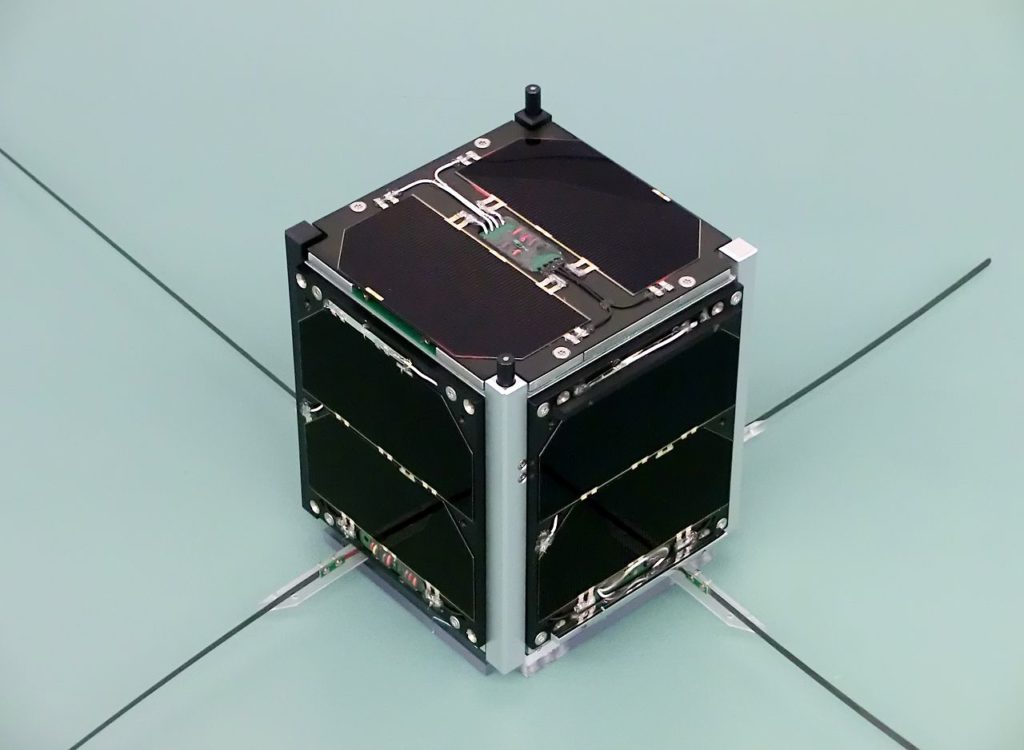
The FUNcube is a CubeSat (a low-cost miniature 10 cm cube-sized satellite) which is intended mainly for educating young people about radio, space, physics and electronics but has also piqued the interest of amateur radio hobbyists. The FUNcube is a project of AMSAT-Uk it is listed as AO73/FUNcube-1

Funcube CubeSat

The FUNcube is of course not a geostationary satellite, which is why we need software that calculates the position of the satellite and shows when it is above our horizon, I use Orbitron.

I am assuming that you have set up your RTL_SDR and your SDR software works and you have a suitable antenna for reception of the signal (note: if you are using a sawbird type LNA it will not pass the signal through to your SDR.)  You’ll also need to have Virtual Cable selected on SDR# so you can pass the audio to the Funcube Dashboard, which can be downloaded here   FUNcube-1 Dashboard v1044

Again, the trick is to get as much as possible from a passage of the FUNcube, especially as a beginner, you should take the opportunity and save the raw data on the hard disk with the help of the SDR software. The lowest sample rate can be selected for SDR# and SDR radio in order to limit the amount of data a bit, since we are only interested in the frequency range between 145.900 and 146 MHz. 

As the FUNcube comes slowly over the horizon, we can see different signals in the spectrum. At about 145.935 MHz plus or minus Doppler shift, you can see the beacon that sends telemetry data at 1200 baud in BPSK.
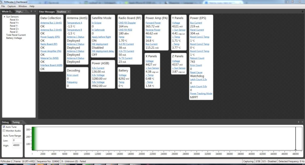
Telemetry data

The software from AMSAT-UK for this, is the FUNcube Dashboard mentioned above. This ensures the decoding of the data that reaches the program via the Virtual Audio cable audio stream, displays it clearly on a concise dashboard display.
In addition, AMSAT-UK came up with a short message service, namely a mixture of Twitter and FUNcube, so Fitter. 

Think Twitter! A Fitter message is a short (200 characters) text like message which can be uploaded to the satellite (via a moderator), and which can be transmitted several times every 5 minutes or so. It will continue to be retransmitted until such time as it is replaced by a new Fitter Message.

So such a message could be something like:

Greeting to Roberts Middle school, which will be holding a special Space Day on June 12 2020. We hope you receive this message OK and have a FUNtime!

So how does reception work in practice? In the Funcube dashboard, under settings, you need to configure the audio input of the dashboard, for your virtual audio cable to match the settings in your SDR# software. With the SDR software, set the modulation type to USB, tune it to 145.935 MHz, and set the bandwidth to a value of, for example, 15 kHz. 

The trick is as follows, the reception frequency changes due to the Doppler effect. On one hand, the dashboard is able to process higher frequencies than the few KHz that are usual for voice transmission via SSB. On the other hand, the software has built-in an automatic frequency correction and searches for the BPSK signal of the FUNcube in the complete NF spectrum.

Data will appear as soon as the dashboard receives a readable signal. You’ll get data from the satellite, such as the voltage of the batteries, temperatures, etc., and this is also shown over time. If the timing is correct and a fitter message is sent as part of the circulation and with a clean signal, this will also be shown in the dashboard.

Hardware Humor Imagery Processing Interesting stuff you should know! Launch News Life News Product Review Satellites Science Software Space Weather Uncategorized VLOG

Satellite And Weather Related Feeds

  • CIMSS Satellite Blog
  • USRadioguy.com
  • wildfires
  • NASA Earth Observatory
  • SPC Particularly Dangerous Situation (PDS) Tornado/Severe Thunderstorm Watch
  • satellites
  • Satellites News -- ScienceDaily
  • Satellite Liaison Blog
1-minute GOES-18 imagery to monitor the potential of flash flooding in American Samoa
Thermal signatures of the Chevron El Segundo refinery fire near Los Angeles
Category 2 Hurricane Imelda passes over Bermuda
SatDump 2.0
SatDump 2.0
WXtoIMG: A Legacy in Weather Satellite Decoding
NOAA 15 and 19 Decommisioning
The fire cycle
New NOAA tool can predict potential wildfires on an hourly basis
Unmasking the complicated chemistry of wildfire smoke: What's in it?
A Desert Intersection
Imelda and Humberto Crowd the Atlantic
The Erie Canal Turns 200
SPC PDS Severe Thunderstorm Watch 399
Experts to preview launch of historic NOAA space weather satellite observatory
Five historically huge solar events
65 years since the world’s first weather satellite
JWST spots a hidden red supergiant just before it exploded
ESA’s chilling new “super antenna” in Australia reaches spacecraft billions of miles away
Webb spots first hints of atmosphere on a potentially habitable world
Gulf of Alaska Hurricane-Force Low
Pesky September Low Impacts Mid-Atlantic
Hurricane Erin: East Coast Impacts and Extratropical Transition
  • Facebook Geo Stationary Satellites
  • Usradioguy Facebook
  • Instagram
  • Reddit
  • Github
  • Linkedin

Copyright © 2025 USRadioguy.com - All Rights Reserved. All material protected by Fair Use Section 107 of the Copyright Act. This site is Verified and Secured with 256 bit SSL encryption

Help Fund USRadioguy.com

USRadioguy Needs Your Help