Skip to content
USRADIOGUY

USRadioguy.com

Welcome to USRadioguy.com – Unlocking the Potential of Software Defined Radio

  • Home
    • Home of USRadioguy
    • Tried and Tested Hardware
    • USRadioguy Newsletter
    • What is RTL-SDR?
    • Global Weather Data
  • Satellite Reception
    • Geo Stationary Satellites
      • Geo-stationary Satellite Imagery Reception
      • GOESTOOLS on the PI
      • Update Goestools for GOES 18,19
      • Receiving GOES with SatDump CLI Mode
      • GOES receiving in Windows for SatDump GUI
      • Decoding EWS-G1/EWS-G2
      • GOES GRB Reception WIP
      • Optimizing a WIFI Grid Antenna for Maximum Efficiency
    • APT Satellites
      • APT RECEPTION
      • Satdump for Meteor and NOAA decoding
      • METEOR M2- Series
      • WxtoImg Fix
      • Converting to new TLE format
      • Layering Fire and Hotspot Data on Meteor Sat Imagery
      • HRPT Satellite Tracking and Capture
    • Receiving Other Satellites
      • Inmarsat Decoding
      • Receiving the Funcube Amateur Satellite
    • User Maps and Dish Pointers
      • Satellite Dish Pointer
      • User Global Ground Station Maps
      • Usermap rendered with Cesium
      • Global Map of Govt Dish Stations
    • Satellite Details & Information
      • ORBITAL DYNAMICS 101
      • HRIT/EMWIN & GRB Defined
      • Mesoscale Imagery Defined
      • Viterbi, R/S Errors, Packets
      • GOES BAND IMAGERY
      • Stray Light Zone (SLZ)
      • Drifting a geostationary satellite
      • GOES-R Series Multimedia Tour
      • Online Satellite Imagery and Information
      • Satellite Frequencies
      • Solar and Space Weather
  • Satellite Imagery
    • IMAGERY- Current GOES East & West HRIT Satellite Imagery
    • IMAGERY- GOES 16&18 – Past 96 Hours of Imagery
    • High Resolution Imagery
    • Daily 3D view of Earth
    • PlanetMaker
    • GOES16 A full year of received imagery
  • Imagery Processing
    • Custom Color Lookup Table & Gradients
    • GOES-R Custom Imagery Scripts
    • Global geo-ring composites
    • MODIS VIIRS Global Coverage
    • 3D Satellite Tracking
    • The quest for True Color Imagery
    • 3D animation of realtime data
    • Layering Geo-Spatial Fire Data into Satellite Imagery
    • Orbital dynamics and the Moon
    • National Hurricane Data
  • News, VLOGS & BLOGS
    • News & USRadioguy Blogs
    • USRadioguy VLOGS
  • Project Lab
    • Orbital Information and Visualizations
      • Enhanced Planet Earth
      • Satellites in Orbit
      • Solar System
      • Objects in Orbit
    • Current Station Weather
      • Current Groundstation Weather
      • Global Weather Data
      • Space Weather
    • WWII RADIO
      • WWII K-24 Aerial Camera
      • WWII RADIO
      • RADIO SET SCR-284
      • VS-3 VIBRATOR CONVERSION
      • VIBRATOR CONVERSION MODULE
      • BD-71 Field Switch Board and EE-8B Field Telephones
      • R-100/URR 1944 MORALE RADIO
      • A PORTABLE WWII ERA “MORALE RADIO”
      • AN/GRR-5 THE ANGRY 5
      • WWII Audio Page
    • Raspberry Pi Projects
      • ADS-B Reception
      • Allsky Camera
      • Pi Based Picture Frame
      • PI Based Broadcastify Server
      • Solar Power for PI
    • Your very Own Weather Satellite
    • Hubble Space Telescope Data Processing
    • Zombie Satellites
    • DRONES
  • About Me
    • About Usradioguy
      • SETEC Astronomy
    • Tried and Tested Hardware
    • Rare Captures
    • My Other Interests
    • Presentations
    • Merchandise
    • Privacy Policy
  • Home
  • Zombie Satellites

Zombie Satellites

Zombie Satellites

There is a lot of stuff in orbit around the earth, and the vast majority is junk, still orbiting the earth. Vanguard I, launched in 1958 has been up there slinging around the earth now for over 6 decades. Long since ‘dead’ other satellites sometimes reach the ends of their lives due to various reasons. In 2010 Galaxy 15, silent for about a year spontaneously reset itself and began transmitting again. Which was bad, because controllers on earth could not control the transmissions, it posed a hazard to other satellites, and they finally figured out how to put it “safe” mode where it remains today.

Recently, The LES-5 satellite launched in 1967, which was an early experiment in satellite-based communications. It was decommissioned and placed in a “graveyard orbit” in 1972. I was considered dead, that is until 2020 when Scott Tilley, an amateur radio operator living in British Columbia, who makes a hobby of re-establishing contact with long-lost satellites, ‘found it” . Tilley has helped NASA locate the IMAGE satellite, lost for 13 years in Earth’s orbit, as well as one of the U.S. Navy’s Transit series of navigational satellites. Recently Tilley took interest in LES-5, an experimental satellite developed by MIT’s Lincoln Lab, and launched into orbit in 1967.

So what else is up there? Well there is NOAA-9, never able to be decommissioned, it lost all orbital control and began tumbling as it orbited the earth. The last contact occurred on February 13, 1998. In late 1999 a transmitter started working again, sending an unmodulated carrier. It seems to transmit while the satellite is in sunlight. Just picture this satellite slowly spinning, solar panels every now and then, when conditions are JUST RIGHT, and someone is listening, you can hear it lonely carrier wave.

I caught this fleeting sound from what I think was NOAA 9 on 136.77 MHz as it was directly above my station on April 29th, 2020. It is only 9 seconds of audio…


My first recording of NOAA 9 in October of 2019

NOAA 9 recorded October 2019

Want to see everything being tracked up there? Heres A real-time interactive WebGL visualisation of objects in Earth orbit http://stuffin.space

Or try out the Celestrak Orbit Visualizer https://celestrak.com/cesium/orbit-viz.php?tle=/pub/TLE/catalog.txt&satcat=/pub/satcat.txt&referenceFrame=1
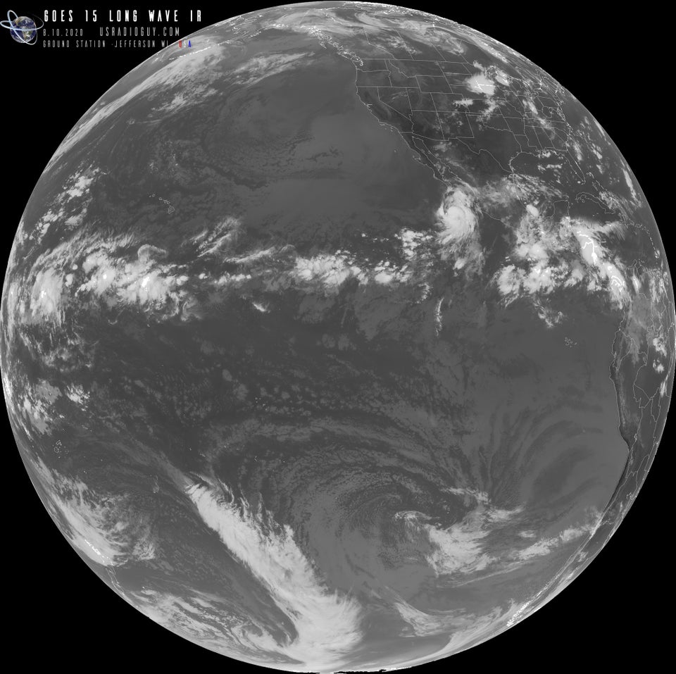
UPDATE! 9/10/2020

While not technically a dead satellite, GOES 15 was taken offline and placed in “orbital storage” in March of 2020 and slated to be used as a backup in case GOES 16, or GOES 17 failed. Well GOES 17 has a problem with its coolant pipes for its ABI instrument. Four times a year, when the Sun really heats up the 17 satellite, they have to run it a bit less frequently. Unfortunately, this happens to coincide with the Pacific cyclone season. So, too pick up the slack, NOAA took GOES 15 out of orbital storage and is using it to fill the gaps in GOES 17 coverage. Here is an example I received from GOES 15, relayed through the GOES 17 Satellite.

GOES 15 Long Wave IR

Another Re purposed satellite is GOES 13

GOES-13 is now transmitting again, now under the direction of the US Space Force and Department of Defense, GOES-13 is now known as the Electro-Optical Infrared Weather System – Geostationary or EWS-G1. EWS-G1 was maneuvered into a new Geostationary Orbit to a new position at 61.5 degrees east longitude in mid-February 2020 over the Indian Ocean. It was declared fully operational (again) on Sept 8, 2020. It is now being received and decoded by other radio hobbyists Decoding EWS-G1 or GOES-13.

Hardware Humor Imagery Processing Interesting stuff you should know! Launch News Life News Product Review Satellites Science Software Space Weather Uncategorized VLOG

Satellite And Weather Related Feeds

  • CIMSS Satellite Blog
  • USRadioguy.com
  • wildfires
  • NASA Earth Observatory
  • SPC Particularly Dangerous Situation (PDS) Tornado/Severe Thunderstorm Watch
  • satellites
  • Satellites News -- ScienceDaily
  • Satellite Liaison Blog
Post-Tropical Cyclone Kiko north of Hawai’i
A Foggy Morning for Lake Superior
Severe thunderstorms produce giant hail and isolated tornadoes in the Southern Plains
SatDump 2.0
SatDump 2.0
WXtoIMG: A Legacy in Weather Satellite Decoding
NOAA 15 and 19 Decommisioning
The fire cycle
New NOAA tool can predict potential wildfires on an hourly basis
Unmasking the complicated chemistry of wildfire smoke: What's in it?
Greenland Ice Sheet Gets a Refresh
Color Along the Anadyr
Monsoon Rains Flood Pakistan
SPC PDS Severe Thunderstorm Watch 399
Experts to preview launch of historic NOAA space weather satellite observatory
Five historically huge solar events
65 years since the world’s first weather satellite
This rare white dwarf looks normal, until Hubble shows its explosive secret
A weirdly shaped telescope could finally find Earth 2. 0
Butterfly nebula reveals sparkling gems, fiery dust, and the ingredients of life
Hurricane Erin: East Coast Impacts and Extratropical Transition
Hurricane Erin (2025) Rapid Intensification
August 2025 Milwaukee Flooding
  • Facebook Geo Stationary Satellites
  • Usradioguy Facebook
  • Instagram
  • Reddit
  • Github
  • Linkedin

Copyright © 2025 USRadioguy.com - All Rights Reserved. All material protected by Fair Use Section 107 of the Copyright Act. This site is Verified and Secured with 256 bit SSL encryption

Help Fund USRadioguy.com

USRadioguy Needs Your Help