Skip to content
USRADIOGUY

USRadioguy.com

Welcome to USRadioguy.com – Unlocking the Potential of Software Defined Radio

  • Home
    • Home of USRadioguy
    • USRadioguy Newsletter
    • Tried and Tested Hardware
    • What is RTL-SDR?
    • Global Weather Data
  • Satellite Reception
    • Geo Stationary Satellites
      • Geo-stationary Satellite Imagery Reception
      • GOESTOOLS on the PI
      • Update Goestools for GOES 18,19
      • Receiving GOES with SatDump CLI Mode
      • GOES receiving in Windows for SatDump GUI
      • Decoding EWS-G1/EWS-G2
      • GOES GRB Reception WIP
      • Optimizing a WIFI Grid Antenna for Maximum Efficiency
    • APT Satellites
      • APT RECEPTION
      • Satdump for Meteor and NOAA decoding
      • METEOR M2- Series
      • WxtoImg Fix
      • Converting to new TLE format
      • Layering Fire and Hotspot Data on Meteor Sat Imagery
      • HRPT Satellite Tracking and Capture
    • Receiving Other Satellites
      • Inmarsat Decoding
      • Receiving the Funcube Amateur Satellite
    • User Maps and Dish Pointers
      • Satellite Dish Pointer
      • User Global Ground Station Maps
      • Usermap rendered with Cesium
      • Global Map of Govt Dish Stations
    • Satellite Details & Information
      • ORBITAL DYNAMICS 101
      • HRIT/EMWIN & GRB Defined
      • Mesoscale Imagery Defined
      • Viterbi, R/S Errors, Packets
      • GOES BAND IMAGERY
      • Stray Light Zone (SLZ)
      • Drifting a geostationary satellite
      • GOES-R Series Multimedia Tour
      • Online Satellite Imagery and Information
      • Satellite Frequencies
      • Solar and Space Weather
  • Satellite Imagery
    • IMAGERY- Current GOES East & West HRIT Satellite Imagery
    • IMAGERY- GOES 16&18 – Past 96 Hours of Imagery
    • High Resolution Imagery
    • Daily 3D view of Earth
    • NOAA APT Satellite imagery
    • PlanetMaker
    • GOES16 A full year of received imagery
  • Imagery Processing
    • Custom Color Lookup Table & Gradients
    • GOES-R Custom Imagery Scripts
    • Global geo-ring composites
    • MODIS VIIRS Global Coverage
    • 3D Satellite Tracking
    • The quest for True Color Imagery
    • 3D animation of realtime data
    • Layering Geo-Spatial Fire Data into Satellite Imagery
    • Orbital dynamics and the Moon
    • National Hurricane Data
  • News, VLOGS & BLOGS
    • News & USRadioguy Blogs
    • USRadioguy VLOGS
  • Project Lab
    • Orbital Information and Visualizations
      • Enhanced Planet Earth
      • Satellites in Orbit
      • Solar System
      • Objects in Orbit
    • Current Station Weather
      • Current Groundstation Weather
      • Global Weather Data
      • Space Weather
    • WWII RADIO
      • WWII K-24 Aerial Camera
      • WWII RADIO
      • RADIO SET SCR-284
      • VS-3 VIBRATOR CONVERSION
      • VIBRATOR CONVERSION MODULE
      • BD-71 Field Switch Board and EE-8B Field Telephones
      • R-100/URR 1944 MORALE RADIO
      • A PORTABLE WWII ERA “MORALE RADIO”
      • AN/GRR-5 THE ANGRY 5
      • WWII Audio Page
    • Raspberry Pi Projects
      • ADS-B Reception
      • Allsky Camera
      • Pi Based Picture Frame
      • PI Based Broadcastify Server
      • Solar Power for PI
    • Hubble Space Telescope Data Processing
    • Zombie Satellites
    • DRONES
  • About Me
    • About Usradioguy
      • SETEC Astronomy
    • Tried and Tested Hardware
    • Rare Captures
    • My Other Interests
    • Presentations
    • Merchandise
    • Privacy Policy
  • Home
  • Science
  • The altered life of GOES-3

The altered life of GOES-3

Posted on March 6, 2023July 10, 2024 By Carl
Interesting stuff you should know!, Satellites, Science

Loading

GOES-3 weather satellite did not go gently into that goodnight….

GOES-3 awaits launch aboard Delta Launch Vehicle 142.Credit: NASA

For over 20 years, the South Pole relied on the GOES-3 weather satellite for communication links with the outside world. However, this satellite was decommissioned in 2016 after 38 years in operation.

GOES-3

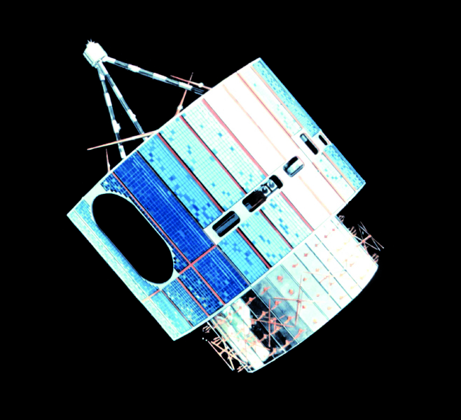
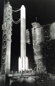
GOES-3 was launched in 1978 aboard a Delta 2914 carrier rocket, the satellite used a Visible/Infrared Spin Scan Radiometer (VISSR) to provide day and night observations of cloud and surface temperatures, cloud heights, and wind fields. Although GOES-3 was spin-stabilized, only viewing Earth less than 10 percent of the time and providing data in only two dimensions, the satellite provided forecasters with some of their first near real-time looks at atmospheric conditions from a fixed location.

NOAA GOES-3 Visible (0.65 µm) images at 1545 and 1615 UTC (above) showed the volcanic cloud shortly after the explosive eruption of Mount St. Helens on 18 May 1980
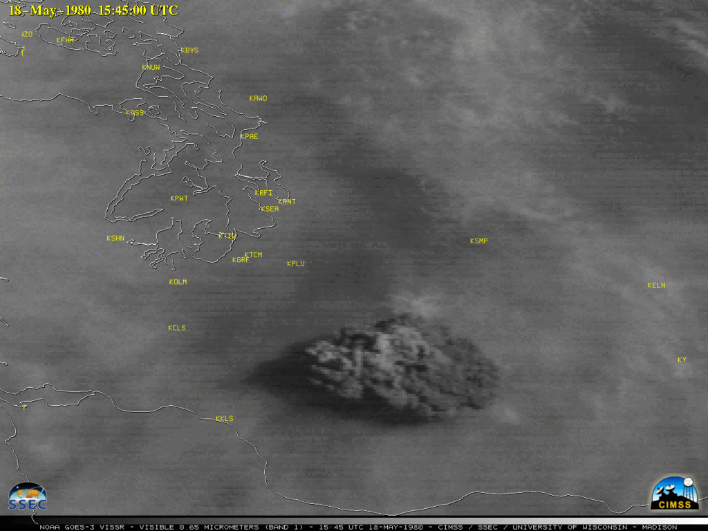
CREDIT: https://cimss.ssec.wisc.edu/satellite-blog/archives/36701

When GOES-3 served its useful life as a weather satellite, GOES-3 was used as a backup for other operational weather satellites in the GOES series. Specifically, it was used as a replacement for GOES-4, which experienced problems with its imager and was unable to provide weather data.

But, what happens when the weather sat cannot “see”?

By 1989, GOES-3 weather-observation instruments had failed, the curtain was being drawn, but GOES-3 did not go gently into that goodnight.

A plan was hatched to repurpose it as a communications satellite. The satellite’s ability to send and receive data from geostationary orbit grabbed the attention of the Pan-Pacific Education and Communications Experiments by Satellite Program or PEACESAT. GOES-3 served as a communications lifeline to the Pacific from 1988 through the early 1990s.

Communication was made possible by the use of the S-Band to L-Band translator on the satellite that was originally intended for the broadcast of processed GOES-3 Visible and Infrared Spin Scan Radiometer (VISSR) imagery processed on the ground and rebroadcast to end-users.

In 1995, the satellite would again change hands and provide a new critical communications link—this time, for the South Pole. So its orbital position was modified to allow it to be used as a communications satellite, specifically for the south pole. Through a series of agreements, NOAA permanently transferred the satellite from PEACESAT to the NSF to be used for direct digital communications between the continental U.S. and the Amundsen-Scott South Pole Station.

The satellite’s inclination station-keeping maneuvers had been eliminated for quite some time due to the low fuel remaining, knocking out its ability to maintain a precise orbital plane. The inclination of GOES-3’s orbital plane, in respect to Earth’s equator, was drifting higher and higher. This unique, high-inclination orbit meant that GOES-3 could make a direct connection between Earth’s polar caps and the United States for 6.5 hours a day—a rare capability that caught the eye of the National Science Foundation (NSF).

Since 1995, it’s been one of the main satellites used to communicate and provide internet service to the Amundsen-Scott South Pole Station and a variety of deep-field science camps in the Antarctic. So yep, the scientists and employees at the south pole bounced those Facebook posts, and likes, and Tweets off a piece of hardware that’s over 30 years old.

Amundsen-Scott’s extreme latitude — 90 degrees south, directly over the pole — makes it impossible to “see” most communications satellites, but due to GOES-3’s oscillation shifted it far enough south for its signals to reach the bottom of the planet for about 6.5 hours per day. The station, which is located at the Earth’s southernmost point, relies on satellite links for communication with the rest of the world. GOES-3 provided around 1.5Mbps up and down, which was sufficient for the station’s needs at the time.

Over the years, the South Pole has relied on a number of different satellites for communication links. However, GOES-3 remained a key part of the station’s infrastructure for more than two decades. It provided a reliable and consistent connection to the outside world, even in the harshest of conditions.

One researcher explained with GOES 3 providing only 1.5 megabits up and down, which is shared throughout the entire station – both for voice as well as data, that traffic gets prioritized, so voice goes through smoothly, then higher priority data like scientific payloads, and then finally normal web surfing. The experience is definitely a bit frustrating to use, but considering their spot down at the south pole, it’s incredible that they were able to get anything at all. In one case, downloading a pdf for an arctic tractor repair manual, took 2 days because of the low bandwidth and 6.5 hours of coverage. And for us satellite reception guys, that’s pointing the dish at about 1° to 3° in elevation!

In 2016, GOES-3 was decommissioned after 38 years in operation. While the satellite had served its purpose admirably, it was no longer capable of meeting the demands of modern communication needs. It was replaced by a newer satellite, which provided higher bandwidth and more advanced capabilities.

In June of 2016, a cooperative effort with partner organizations, scientists, and engineers, planned and executed the maneuvers for the decommissioning, which was completed on June 29.

NSF, NOAA, and Lockheed Martin, which oversaw the subcontract to operate the satellite, marked the decommissioning, itself a complex undertaking, as a milestone in telecommunications history.

“This was a carefully planned and collaborative operation,” said Art Ibers, vice president of Exploration and Mission Support at Lockheed Martin Information Systems and Global Solutions. “Over 14 days and 20 orbital adjustment maneuvers, the satellite was carefully nudged into a ‘graveyard’ orbit, safely removed from the other still-operating geostationary satellites by about 250 kilometers. After reaching its higher orbit and ensuring that all fuel on-board had been depleted, the satellite’s operators started shutting off its systems one by one, until finally commanding it to turn off telemetry, making it completely passive.”

The decommissioning phase ended on June 29, 2016, placing GOES-3 in the history books as the “One of the Oldest Continuously Operating Spacecraft in History” with a service life of 38 years and 13 days.

GOES-3 communications were done using the 9-meter South Pole Marisat-GOES Terminal (SPMGT), Prior to enclosure under a radome, circa 2002. This platform also has the smaller GOES-3 backup antenna.  (NSF photo)

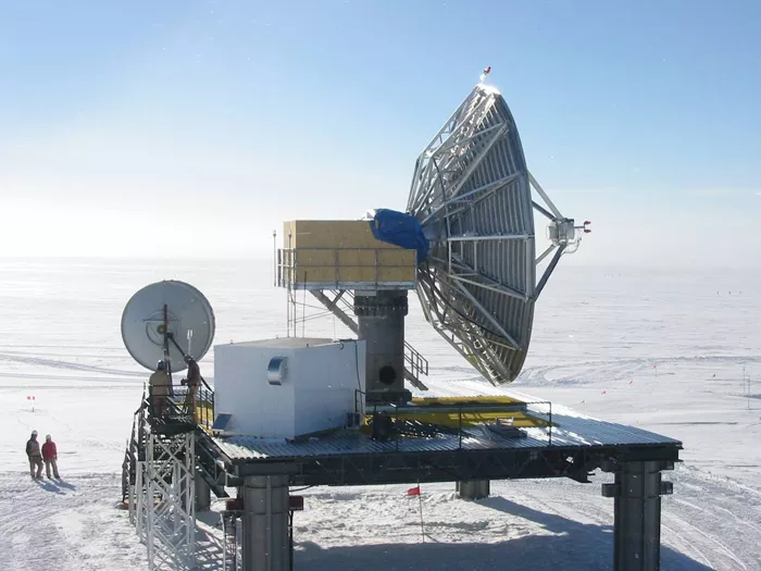
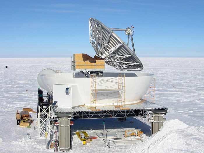
Post Script- maintaining the ground station at the South Pole.

Working and staying alive is hard enough for people at the south pole, but equipment? The inhospitable climate wrecks havoc on everything from snow machines to, yep, you guessed it, satellite ground stations.

In July of 2008, the gears that move the nine-meter-wide dish up and down to track two of the three satellites that provide voice and Internet communications to the station quite literally ground to a halt. To help solve a recurring problem with the lubricant freezing, personnel had tried a new type of grease that was supposed to retain consistency in temperatures down to -150° Fahrenheit (-101° Celcius).

“It turns out that it doesn’t,” The grease turned to a solid at -50° Fahrenheit!. Temperatures at the South Pole can plunge to below -100° Fahrenheit, the satellite dish is located in an enclosed but unheated radome. 

The dish was trying to track the satellite, but with the grease in solid form, the gears of the tracker operated without lubrication and ground themselves into pieces.

They were able to isolate the problem to the jackscrew assembly, which controls the vertical movement of the dish. So, enlisting the help of a heavy equipment operator, satellite guys, and the vehicle maintenance supervisor, they collectively Macgyvered the temp fix. Taking the jackscrew assembly apart, they rotated the gear 180° so that the portion of the gear that hadn’t been too damaged would work with a different wear pattern. They closed it up, with a homemade concoction of grease, and the system began to work.

The conditions under which the repairs were made make the feat even more impressive, all the activities … were conducted in temperature conditions within the antenna shelter that approached -60° Fahrenheit!

Building the radome

Post navigation

❮ Previous Post: Who are Satellite Data and Imaging Enthusiasts?
Next Post: SARSAT: The Technology Behind Saving Lives ❯

You may also like

Satellites
Online Dish Pointer
January 22, 2023
Satellites
GOES-T Mated to Atlas-V
February 18, 2022
Satellites
GOES-T: Road to Launch
November 9, 2021
Hardware
Kraken Discovery Dish Progress
June 28, 2024

Please, Help Support USRadioguy.com

If you like what I do please support me on Ko-fi, It really means a lot, every bit helps!

Hardware Humor Imagery Processing Interesting stuff you should know! Launch News Life News Product Review Satellites Science Software Space Weather Uncategorized VLOG

Alphabetical Listing of all Pages on site:

  • 36-Hour Imagery Processing script
  • 3D animation of realtime data
  • A PORTABLE WWII ERA “MORALE RADIO”
  • About Me
  • ADS-B Reception
  • Allsky Camera
  • AN/GRR-5 THE ANGRY 5
  • BD-71 Field Switch Board and EE-8B Field Telephones
  • Current GOES 16 & 18 False Color Satellite Imagery
  • Custom Color Lookup Table
  • Custom Imagery Scripts for GOES
  • Daily 3D view of Earth
  • Daily Global Composites
  • Decoding EWS-G1 or GOES-13
  • Drifting a geostationary satellite
  • DRONE FUN
  • Even the kitchen sink
  • GEO-RING COMPOSITES
  • GEO-SAT PI FRAME
  • Geo-stationary Satellite Imagery Reception
  • Global Weather Data
  • GOES 19&18 – Last 96 Hours of Imagery
  • GOES BAND IMAGERY
  • GOES GRB Reception
  • GOES receiving in Windows for SatDump
  • GOES-18 Preparing for a new satellite
  • GOES-R Series Multimedia Tour
  • GOES-U (19) Countdown to Launch
  • GOES16 A full year of received imagery
  • Ground Station Map
  • High Resolution Imagery
  • Home
  • House History
  • HRIT/EMWIN & GRB
  • HRPT Satellite Tracking and Capture
  • Hubble Space Telescope Data Processing
  • Inmarsat Decoding
  • Layering Fire and Hotspot Data on Meteor Sat Imagery
  • Layering Geo-Spatial Fire Data into Satellite Imagery
  • Mesoscale Imagery Defined
  • METEOR M2- Series
  • MODIS VIIRS Global Coverage
  • My Other Interests
  • NASA, NOAA, Military, GOVT dish, and tower stations.
  • National Hurricane Data
  • Newsletter terms & conditions
  • NOAA & Meteor APT and LRPT RECEPTION
  • Online Satellite Imagery and Information
  • Optimizing a WIFI Grid Antenna for Maximum Efficiency
  • ORBITAL DYNAMICS 101
  • Orbitron, Gpredict, and PSTRotator with new TLE format
  • PI Based Broadcastify Server
  • Pi Based Picture Frame
  • Presentations
  • Privacy Policy
  • Programming the PI for goestools operation
  • R-100/URR 1944 MORALE RADIO
  • RADIO SET SCR-284
  • Rare Captures
  • Receiving GOES 18,19 with goestools
  • Receiving GOES HRIT with SATDUMP
  • Receiving the Funcube Amateur Satellite
  • Satdump for Meteor and NOAA decoding
  • Satellite Finder
  • Satellite Frequencies
  • Satellite Ground Stations
  • Satellite Tracking
  • Security
  • SETEC Astronomy
  • Solar Power for PI
  • South America GOES 16
  • Space Weather
  • Stray Light Zone (SLZ)
  • Thanks!
  • The quest for True Color Imagery
  • Tried and Tested Hardware
  • Usradioguy Blogs
  • Usradioguy Merchandise
  • USRadioguy Newsletter
  • USRadioguy VLOGS
  • USRADIOGUY Youtube Page
  • VIBRATOR CONVERSION MODULE
  • Viterbi, R/S Errors, Packets
  • VS-3 VIBRATOR CONVERSION
  • What is RTL-SDR?
  • WWII Audio Page
  • WWII K-24 Aerial Camera
  • WWII RADIO
  • WxtoImg Fix
  • Zombie Satellites

Hardware Humor Imagery Processing Interesting stuff you should know! Launch News Life News Product Review Satellites Science Software Space Weather Uncategorized VLOG

Satellite And Weather Related Feeds

  • CIMSS Satellite Blog
  • USRadioguy.com
  • wildfires
  • NASA Earth Observatory
  • SPC Particularly Dangerous Situation (PDS) Tornado/Severe Thunderstorm Watch
  • satellites
  • Satellites News -- ScienceDaily
  • Satellite Liaison Blog
Trout Fire in New Mexico produces a pyrocumulonimbus cloud
Blowing dust in Argentina
Canadian wildfire smoke over Alaska
End Of Life for NOAA 15 and 19?….not so fast…
Vitality GOES
Vitality GOES
Decommissioning NOAA-18
The fire cycle
Unmasking the complicated chemistry of wildfire smoke: What's in it?
NOAA unveils powerful convergence of AI and science with revolutionary Next-Generation Fire System technology
Earth’s Clouds on the Move
Seasonal Breakup in the Amundsen Gulf
Egypt’s Mediterranean Coast
SPC PDS Severe Thunderstorm Watch 399
Five historically huge solar events
65 years since the world’s first weather satellite
Investing in America: NOAA's Science, Service and Stewardship in Action
Satellite measures CO2 and NO2 simultaneously from power plant emissions for the first time
Existing international law can help secure peace and security in outer space
Small, faint and 'unexpected in a lot of different ways': Astronomers make galactic discovery
Late-Season Atlantic Hurricane-Force Low
Atmospheric River Strikes Eastern U.S.
Another Week, Another Deep South Soaker
  • Facebook Geo Stationary Satellites
  • Usradioguy Facebook
  • Instagram
  • Reddit
  • Github
  • Linkedin

Copyright © 2025 USRadioguy.com - All Rights Reserved. All material protected by Fair Use Section 107 of the Copyright Act. This site is Verified and Secured with 256 bit SSL encryption