Skip to content
USRADIOGUY

USRadioguy.com

Welcome to USRadioguy.com – Unlocking the Potential of Software Defined Radio

  • Home
    • Home of USRadioguy
    • USRadioguy Newsletter
    • Tried and Tested Hardware
    • What is RTL-SDR?
    • Global Weather Data
  • Satellite Reception
    • Geo Stationary Satellites
      • Geo-stationary Satellite Imagery Reception
      • GOESTOOLS on the PI
      • Update Goestools for GOES 18,19
      • Receiving GOES with SatDump CLI Mode
      • GOES receiving in Windows for SatDump GUI
      • Decoding EWS-G1/EWS-G2
      • GOES GRB Reception WIP
      • Optimizing a WIFI Grid Antenna for Maximum Efficiency
    • APT Satellites
      • APT RECEPTION
      • Satdump for Meteor and NOAA decoding
      • METEOR M2- Series
      • WxtoImg Fix
      • Converting to new TLE format
      • Layering Fire and Hotspot Data on Meteor Sat Imagery
      • HRPT Satellite Tracking and Capture
    • Receiving Other Satellites
      • Inmarsat Decoding
      • Receiving the Funcube Amateur Satellite
    • User Maps and Dish Pointers
      • Satellite Dish Pointer
      • User Global Ground Station Maps
      • Usermap rendered with Cesium
      • Global Map of Govt Dish Stations
    • Satellite Details & Information
      • ORBITAL DYNAMICS 101
      • HRIT/EMWIN & GRB Defined
      • Mesoscale Imagery Defined
      • Viterbi, R/S Errors, Packets
      • GOES BAND IMAGERY
      • Stray Light Zone (SLZ)
      • Drifting a geostationary satellite
      • GOES-R Series Multimedia Tour
      • Online Satellite Imagery and Information
      • Satellite Frequencies
      • Solar and Space Weather
  • Satellite Imagery
    • IMAGERY- Current GOES East & West HRIT Satellite Imagery
    • IMAGERY- GOES 16&18 – Past 96 Hours of Imagery
    • High Resolution Imagery
    • Daily 3D view of Earth
    • NOAA APT Satellite imagery
    • PlanetMaker
    • GOES16 A full year of received imagery
  • Imagery Processing
    • Custom Color Lookup Table & Gradients
    • GOES-R Custom Imagery Scripts
    • Global geo-ring composites
    • MODIS VIIRS Global Coverage
    • 3D Satellite Tracking
    • The quest for True Color Imagery
    • 3D animation of realtime data
    • Layering Geo-Spatial Fire Data into Satellite Imagery
    • Orbital dynamics and the Moon
    • National Hurricane Data
  • News, VLOGS & BLOGS
    • News & USRadioguy Blogs
    • USRadioguy VLOGS
  • Project Lab
    • Orbital Information and Visualizations
      • Enhanced Planet Earth
      • Satellites in Orbit
      • Solar System
      • Objects in Orbit
    • Current Station Weather
      • Current Groundstation Weather
      • Global Weather Data
      • Space Weather
    • WWII RADIO
      • WWII K-24 Aerial Camera
      • WWII RADIO
      • RADIO SET SCR-284
      • VS-3 VIBRATOR CONVERSION
      • VIBRATOR CONVERSION MODULE
      • BD-71 Field Switch Board and EE-8B Field Telephones
      • R-100/URR 1944 MORALE RADIO
      • A PORTABLE WWII ERA “MORALE RADIO”
      • AN/GRR-5 THE ANGRY 5
      • WWII Audio Page
    • Raspberry Pi Projects
      • ADS-B Reception
      • Allsky Camera
      • Pi Based Picture Frame
      • PI Based Broadcastify Server
      • Solar Power for PI
    • Hubble Space Telescope Data Processing
    • Zombie Satellites
    • DRONES
  • About Me
    • About Usradioguy
      • SETEC Astronomy
    • Tried and Tested Hardware
    • Rare Captures
    • My Other Interests
    • Presentations
    • Merchandise
    • Privacy Policy
  • Home
  • Science
  • Argh-who took a chunk out of my image?

Argh-who took a chunk out of my image?

Posted on May 5, 2024February 22, 2025 By Carl
Imagery Processing, Interesting stuff you should know!, Satellites, Science

Loading

Argh-who took a chunk out of my image?

Updated 01.14.2025

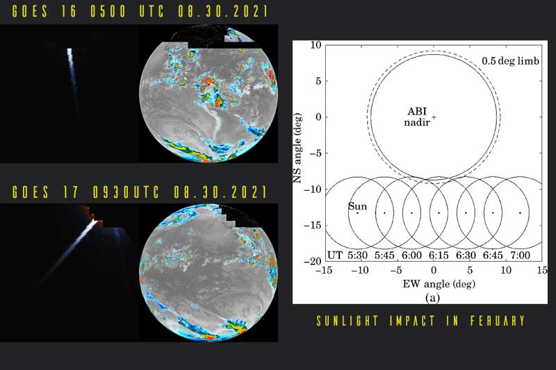
If you are seeing strange images around 05:00 -09:30 UTC Depending on orbital position and satellite, like the ones below, don’t immediately run to check all your settings and connections!!

It can happen around satellite local midnight time, and the ABI would see a direct head-on view of the sun near the edge of the earth. This could damage the ABI imager (in the same way as your eye’s retina or camera sensor could be damaged) so steps are taken to prevent this from happening while preserving as much of the rest of the image as possible.

GOES satellites encounter two periods during the year in which they are in Earth’s shadow. Known as the Eclipse (ECL) season, these periods require the spacecraft to be completely dependent upon batteries for a maximum of 72 minutes daily. Eclipses occur approximately from late February to mid-April, and from late August to mid-October.

During eclipse season with the GOES-R satellite series, stray light contamination is visible approximately 45 minutes before and after satellite local midnight (~0500 UTC for GOES-East and ~0900 UTC for GOES-West) each day for approximately 45 days before and after the vernal and autumnal equinox, in the form of a vertical beam of light that is more intense at the end closer to the Sun. Stray light contamination is often prominent in the images of visible and near-infrared bands (bands 1–6), although it can also be discerned in band 7 images. This is a normal occurrence for the ABI.

But how? To avoid direct solar light contamination onto the ABI detectors and maintain healthy performance of the ABI sensor, the solar avoidance routine was scheduled by analyzing part of the ABI swaths according to the angle between the ABI instrument and solar position at certain times of the year, then steering the ABI scan mirrors away from observing the scan lines of the Earth scene during that time period.

The Lens flare (the little lightning bolt-shaped flare), is caused when the refraction of light passing through the atmosphere of the earth (the angle of solar light through the atmosphere can be as large as 0.6°) is great enough to still hit a portion of the ABI imager.

Since each band absorbs a differing bandwidth of light, a compromise equation of all bands is used to try and get the maximum amount of usable imagery on all bands. This will ‘flip’ to the southern hemisphere in February.

Pacman has been busy

Additional Impacts

During eclipse season with the GOES-R satellite series Geostationary Lightning Mapper (GLM), solar intrusion into the lens assembly will result in localized blooming (false events) and saturation (blind regions) in the data. These effects will occur daily around the same time as the ABI effects (0500 UTC and 0900 UTC). The daily effects begin with many false events at the limb, which cover regions of varying size and location as the eclipse features move across the field of view. The false events will peak during the beginning and end of the eclipse season and the 20-second files will intermittently peak in size above 3-5 MB per file during false events, which is well above the average of ~0.3 MB per file.

The increased number of false events can cause an overflow condition in the electronics which saturates the event processing. This saturation creates blind regions in the data outside of the areas impacted by the solar intrusion. The length of these temporary outages depends on the region, and is on the order of minutes. A blooming filter is being developed to remove the event spikes, although lightning detection outages will remain in the affected regions.


There is a significant risk of light from the sun directly entering the scanners and causing degraded products as the spacecraft enters and leaves the Earth’s shadow, requiring a special algorithm to be applied to the Imager products. In some instances shifting, cancelling, or truncating the frame is necessary. This is known as the “Stray Light Zone (SLZ).”


Looking for hardware recommendations?? Have a look here at my Tried and Tested hardware – SDR’s Pi’s, Connectors, Antenna’s, and more.

Tags: Satellite Imagery

Post navigation

❮ Previous Post: Satellite Processing-Science vs Art:
Next Post: Ham It Up Nano by Nooelec ❯

You may also like

USRadioguy VLOG
Life
USRadioguy VLOG
February 19, 2023
NOAA 15
Satellites
NOAA 15,18,19 to transition to private On-orbit operations
October 20, 2022
Science
GOES-T mated to the payload adapter
January 29, 2022
Imagery Processing
Hunga Tonga Eruption
January 20, 2024

Please, Help Support USRadioguy.com

If you like what I do please support me on Ko-fi, It really means a lot, every bit helps!

Hardware Humor Imagery Processing Interesting stuff you should know! Launch News Life News Product Review Satellites Science Software Space Weather Uncategorized VLOG

Alphabetical Listing of all Pages on site:

  • 36-Hour Imagery Processing script
  • 3D animation of realtime data
  • A PORTABLE WWII ERA “MORALE RADIO”
  • About Me
  • ADS-B Reception
  • Allsky Camera
  • AN/GRR-5 THE ANGRY 5
  • BD-71 Field Switch Board and EE-8B Field Telephones
  • Current GOES 16 & 18 False Color Satellite Imagery
  • Custom Color Lookup Table
  • Custom Imagery Scripts for GOES
  • Daily 3D view of Earth
  • Daily Global Composites
  • Decoding EWS-G1 or GOES-13
  • Drifting a geostationary satellite
  • DRONE FUN
  • Even the kitchen sink
  • GEO-RING COMPOSITES
  • GEO-SAT PI FRAME
  • Geo-stationary Satellite Imagery Reception
  • Global Weather Data
  • GOES 19&18 – Last 96 Hours of Imagery
  • GOES BAND IMAGERY
  • GOES GRB Reception
  • GOES receiving in Windows for SatDump
  • GOES-18 Preparing for a new satellite
  • GOES-R Series Multimedia Tour
  • GOES-U (19) Countdown to Launch
  • GOES16 A full year of received imagery
  • Ground Station Map
  • High Resolution Imagery
  • Home
  • House History
  • HRIT/EMWIN & GRB
  • HRPT Satellite Tracking and Capture
  • Hubble Space Telescope Data Processing
  • Inmarsat Decoding
  • Layering Fire and Hotspot Data on Meteor Sat Imagery
  • Layering Geo-Spatial Fire Data into Satellite Imagery
  • Mesoscale Imagery Defined
  • METEOR M2- Series
  • MODIS VIIRS Global Coverage
  • My Other Interests
  • NASA, NOAA, Military, GOVT dish, and tower stations.
  • National Hurricane Data
  • Newsletter terms & conditions
  • NOAA & Meteor APT and LRPT RECEPTION
  • Online Satellite Imagery and Information
  • Optimizing a WIFI Grid Antenna for Maximum Efficiency
  • ORBITAL DYNAMICS 101
  • Orbitron, Gpredict, and PSTRotator with new TLE format
  • PI Based Broadcastify Server
  • Pi Based Picture Frame
  • Presentations
  • Privacy Policy
  • Programming the PI for goestools operation
  • R-100/URR 1944 MORALE RADIO
  • RADIO SET SCR-284
  • Rare Captures
  • Receiving GOES 18,19 with goestools
  • Receiving GOES HRIT with SATDUMP
  • Receiving the Funcube Amateur Satellite
  • Satdump for Meteor and NOAA decoding
  • Satellite Finder
  • Satellite Frequencies
  • Satellite Ground Stations
  • Satellite Tracking
  • Security
  • SETEC Astronomy
  • Solar Power for PI
  • South America GOES 16
  • Space Weather
  • Stray Light Zone (SLZ)
  • Thanks!
  • The quest for True Color Imagery
  • Tried and Tested Hardware
  • Usradioguy Blogs
  • Usradioguy Merchandise
  • USRadioguy Newsletter
  • USRadioguy VLOGS
  • USRADIOGUY Youtube Page
  • VIBRATOR CONVERSION MODULE
  • Viterbi, R/S Errors, Packets
  • VS-3 VIBRATOR CONVERSION
  • What is RTL-SDR?
  • WWII Audio Page
  • WWII K-24 Aerial Camera
  • WWII RADIO
  • WxtoImg Fix
  • Zombie Satellites

Hardware Humor Imagery Processing Interesting stuff you should know! Launch News Life News Product Review Satellites Science Software Space Weather Uncategorized VLOG

Satellite And Weather Related Feeds

  • CIMSS Satellite Blog
  • USRadioguy.com
  • wildfires
  • NASA Earth Observatory
  • SPC Particularly Dangerous Situation (PDS) Tornado/Severe Thunderstorm Watch
  • satellites
  • Satellites News -- ScienceDaily
  • Satellite Liaison Blog
Using Polar2grid and Direct Broadcast files to create imagery
Cirrus over the western Great Lakes
Wildfire in Saskatchewan produces a pyrocumulonimbus cloud
End Of Life for NOAA 15,18,19?….not so fast…
GOES-19 now GOES-EAST
GOES 19 Operational Schedule
The fire cycle
March was nation's 6th warmest on record
Podcast: Could the LA Wildfires harm California's marine life?
Mapping the Tiny Plankton That Feed Giant Right Whales
Lights of Southeast Asia
The Arches That Salt Built
SPC PDS Tornado Watch 98
Five historically huge solar events
65 years since the world’s first weather satellite
Investing in America: NOAA's Science, Service and Stewardship in Action
Satellite measures CO2 and NO2 simultaneously from power plant emissions for the first time
Existing international law can help secure peace and security in outer space
Small, faint and 'unexpected in a lot of different ways': Astronomers make galactic discovery
Another Week, Another Deep South Soaker
4 May 2025 Dust and Accumulating Hail
Southern Plains Deluge
  • Facebook Geo Stationary Satellites
  • Usradioguy Facebook
  • Instagram
  • Reddit
  • Github
  • Linkedin

Copyright © 2025 USRadioguy.com - All Rights Reserved. All material protected by Fair Use Section 107 of the Copyright Act. This site is Verified and Secured with 256 bit SSL encryption