Skip to content
USRADIOGUY

USRadioguy.com

Welcome to USRadioguy.com – Unlocking the Potential of Software Defined Radio

  • Home
    • Home of USRadioguy
    • USRadioguy Newsletter
    • Tried and Tested Hardware
    • What is RTL-SDR?
    • Global Weather Data
  • Satellite Reception
    • Geo Stationary Satellites
      • Geo-stationary Satellite Imagery Reception
      • GOESTOOLS on the PI
      • Update Goestools for GOES 18,19
      • Receiving GOES with SatDump CLI Mode
      • GOES receiving in Windows for SatDump GUI
      • Decoding EWS-G1/EWS-G2
      • GOES GRB Reception WIP
      • Optimizing a WIFI Grid Antenna for Maximum Efficiency
    • APT Satellites
      • APT RECEPTION
      • Satdump for Meteor and NOAA decoding
      • METEOR M2- Series
      • WxtoImg Fix
      • Converting to new TLE format
      • Layering Fire and Hotspot Data on Meteor Sat Imagery
      • HRPT Satellite Tracking and Capture
    • Receiving Other Satellites
      • Inmarsat Decoding
      • Receiving the Funcube Amateur Satellite
    • User Maps and Dish Pointers
      • Satellite Dish Pointer
      • User Global Ground Station Maps
      • Usermap rendered with Cesium
      • Global Map of Govt Dish Stations
    • Satellite Details & Information
      • ORBITAL DYNAMICS 101
      • HRIT/EMWIN & GRB Defined
      • Mesoscale Imagery Defined
      • Viterbi, R/S Errors, Packets
      • GOES BAND IMAGERY
      • Stray Light Zone (SLZ)
      • Drifting a geostationary satellite
      • GOES-R Series Multimedia Tour
      • Online Satellite Imagery and Information
      • Satellite Frequencies
      • Solar and Space Weather
  • Satellite Imagery
    • IMAGERY- Current GOES East & West HRIT Satellite Imagery
    • IMAGERY- GOES 16&18 – Past 96 Hours of Imagery
    • High Resolution Imagery
    • Daily 3D view of Earth
    • NOAA APT Satellite imagery
    • PlanetMaker
    • GOES16 A full year of received imagery
  • Imagery Processing
    • Custom Color Lookup Table & Gradients
    • GOES-R Custom Imagery Scripts
    • Global geo-ring composites
    • MODIS VIIRS Global Coverage
    • 3D Satellite Tracking
    • The quest for True Color Imagery
    • 3D animation of realtime data
    • Layering Geo-Spatial Fire Data into Satellite Imagery
    • Orbital dynamics and the Moon
    • National Hurricane Data
  • News, VLOGS & BLOGS
    • News & USRadioguy Blogs
    • USRadioguy VLOGS
  • Project Lab
    • Orbital Information and Visualizations
      • Enhanced Planet Earth
      • Satellites in Orbit
      • Solar System
      • Objects in Orbit
    • Current Station Weather
      • Current Groundstation Weather
      • Global Weather Data
      • Space Weather
    • WWII RADIO
      • WWII K-24 Aerial Camera
      • WWII RADIO
      • RADIO SET SCR-284
      • VS-3 VIBRATOR CONVERSION
      • VIBRATOR CONVERSION MODULE
      • BD-71 Field Switch Board and EE-8B Field Telephones
      • R-100/URR 1944 MORALE RADIO
      • A PORTABLE WWII ERA “MORALE RADIO”
      • AN/GRR-5 THE ANGRY 5
      • WWII Audio Page
    • Raspberry Pi Projects
      • ADS-B Reception
      • Allsky Camera
      • Pi Based Picture Frame
      • PI Based Broadcastify Server
      • Solar Power for PI
    • Hubble Space Telescope Data Processing
    • Zombie Satellites
    • DRONES
  • About Me
    • About Usradioguy
      • SETEC Astronomy
    • Tried and Tested Hardware
    • Rare Captures
    • My Other Interests
    • Presentations
    • Merchandise
    • Privacy Policy
  • Home
  • Science
  • The new CCOR instrument aboard GOES-U

The new CCOR instrument aboard GOES-U

Posted on July 7, 2024July 10, 2024 By Carl
Hardware, Satellites, Science

Loading

Monitoring Coronal Mass Ejections

Updated July 7, 2024

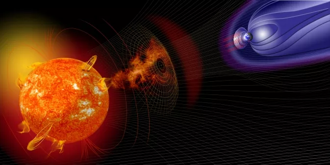
Our Sun, a colossal ball of plasma, is a dynamic entity, constantly emitting flares, eruptions, and streams of charged particles. Among these phenomena are Coronal Mass Ejections (CMEs), massive expulsions of solar material that can travel millions of miles per hour and pose significant risks to Earth’s infrastructure and technology. To monitor these solar storms and assess their potential impact, scientists rely on a network of specialized instruments, including the newly developed Compact Coronagraph (CCOR-1).

The CCOR-1 is a cutting-edge instrument designed to reside on the Sun-Pointing Platform (SPP) of the Geostationary Operational Environmental Satellite (GOES)-U. The GOES-U satellite, the final in the GOES-R Series, launched in April 2024 and will provide a comprehensive suite of Earth observations, including weather monitoring, oceanography, and space weather surveillance.

CCOR-1, funded by the National Oceanic and Atmospheric Administration (NOAA) and managed by the National Aeronautics and Space Administration (NASA), will play a pivotal role in alerting our planet about solar storms. By capturing high-resolution images of the Sun’s coronal white-light, CCOR-1 will enable scientists to determine the size, velocity, and density of CMEs with unprecedented precision.

This detailed information will be crucial for assessing the potential impact of these solar storms on Earth’s power grids, communication networks, and satellite systems. Additionally, it will aid in the development of more accurate space weather forecasts, allowing for timely mitigation strategies and risk reduction measures.

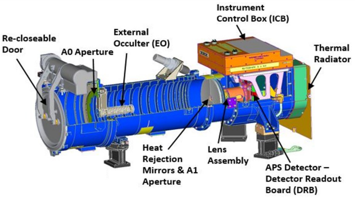
The CCOR-1 instrument has successfully completed its Integration and Testing (I&T) phase and has been delivered to the GOES-U satellite vendor. It is now mechanically integrated with the spacecraft, ready for the final stages of testing and preparation for launch. With the deployment of CCOR-1, we will gain a new level of understanding and preparedness for the Sun’s dynamic activity, ensuring the protection of our planet and its inhabitants.

GOES-U Solar Platform at the Lockheed Martin High Bay in Waterton, Colorado. From
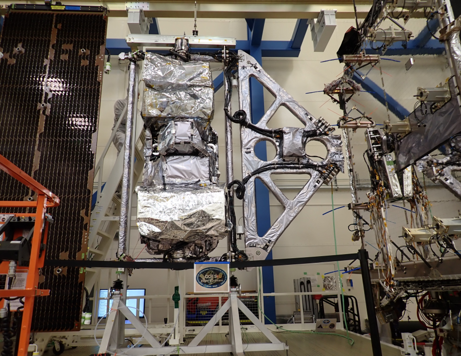
the top going down the instruments include: EXIS, CCOR, CCOR PSB, SUVI SEB, and SUVI STS.
Image courtesy Lockheed Martin

Ground System Overview

The CCOR Ground System is a software system that provides the necessary infrastructure for operating the CCOR instrument. It is hosted on the existing GOES-R Ground System, which provides a robust and scalable platform for managing and processing CCOR data.

Key Functionalities

  • Command and Control: The Ground System handles the formatting of instrument commands, including memory management, and receives and processes CCOR raw telemetry data. It also receives and checks CCOR science data packets.
  • Mission Planning and Scheduling: The Ground System integrates CCOR-related tasks into the GOES-U schedule, ensuring that the instrument is operated efficiently and effectively.
  • Data Operations: The Ground System distributes Level 0 (L0) data to the NOAA Level Zero Storage Service in the Cloud (LZSSc) for retrospective users. It also distributes L0 data and housekeeping data to the SWPC for the near real-time generation of Level 1b and Level 2+ products.

Here are some of the key benefits of CCOR:

  • Improved CME imagery: CCOR will provide higher-resolution imagery of the Sun’s corona than LASCO, which will allow scientists to better understand the structure and evolution of CMEs.
  • Faster CME detection: CCOR will provide imagery of the Sun’s corona within 30 minutes of acquisition, which is significantly faster than LASCO. This will give scientists more time to issue warnings and take action to protect critical infrastructure from the effects of CMEs.
  • Greater CME coverage: CCOR will provide continuous coverage of the Sun’s corona, whereas LASCO can only provide imagery of the Sun’s corona when SOHO is facing the Earth. This will allow scientists to track CMEs that are directed towards the Earth and assess their potential impact.
Tags: GOES-19 GOES-U hardware Satellite

Post navigation

❮ Previous Post: GEONETCast Americas
Next Post: GOES-U now GOES-19 ❯

You may also like

Satellites
GOES T Launch bumped to March 1, 2022
November 18, 2021
Satellites
Post Processing of received imagery.
December 28, 2021
CCOR-1
Interesting stuff you should know!
GOES-19 CCOR-1 Coronagraph Preliminary Non Operational Data
February 8, 2025
Satellite Orbiting Earth
Satellites
Himawari-8 to Himawari-9 Transition
December 11, 2022

Please, Help Support USRadioguy.com

If you like what I do please support me on Ko-fi, It really means a lot, every bit helps!

Hardware Humor Imagery Processing Interesting stuff you should know! Launch News Life News Product Review Satellites Science Software Space Weather Uncategorized VLOG

Alphabetical Listing of all Pages on site:

  • 36-Hour Imagery Processing script
  • 3D animation of realtime data
  • A PORTABLE WWII ERA “MORALE RADIO”
  • About Me
  • ADS-B Reception
  • Allsky Camera
  • AN/GRR-5 THE ANGRY 5
  • BD-71 Field Switch Board and EE-8B Field Telephones
  • Current GOES 16 & 18 False Color Satellite Imagery
  • Custom Color Lookup Table
  • Custom Imagery Scripts for GOES
  • Daily 3D view of Earth
  • Daily Global Composites
  • Decoding EWS-G1 or GOES-13
  • Drifting a geostationary satellite
  • DRONE FUN
  • Even the kitchen sink
  • GEO-RING COMPOSITES
  • GEO-SAT PI FRAME
  • Geo-stationary Satellite Imagery Reception
  • Global Weather Data
  • GOES 19&18 – Last 96 Hours of Imagery
  • GOES BAND IMAGERY
  • GOES GRB Reception
  • GOES receiving in Windows for SatDump
  • GOES-18 Preparing for a new satellite
  • GOES-R Series Multimedia Tour
  • GOES-U (19) Countdown to Launch
  • GOES16 A full year of received imagery
  • Ground Station Map
  • High Resolution Imagery
  • Home
  • House History
  • HRIT/EMWIN & GRB
  • HRPT Satellite Tracking and Capture
  • Hubble Space Telescope Data Processing
  • Inmarsat Decoding
  • Layering Fire and Hotspot Data on Meteor Sat Imagery
  • Layering Geo-Spatial Fire Data into Satellite Imagery
  • Mesoscale Imagery Defined
  • METEOR M2- Series
  • MODIS VIIRS Global Coverage
  • My Other Interests
  • NASA, NOAA, Military, GOVT dish, and tower stations.
  • National Hurricane Data
  • Newsletter terms & conditions
  • NOAA & Meteor APT and LRPT RECEPTION
  • Online Satellite Imagery and Information
  • Optimizing a WIFI Grid Antenna for Maximum Efficiency
  • ORBITAL DYNAMICS 101
  • Orbitron, Gpredict, and PSTRotator with new TLE format
  • PI Based Broadcastify Server
  • Pi Based Picture Frame
  • Presentations
  • Privacy Policy
  • Programming the PI for goestools operation
  • R-100/URR 1944 MORALE RADIO
  • RADIO SET SCR-284
  • Rare Captures
  • Receiving GOES 18,19 with goestools
  • Receiving GOES HRIT with SATDUMP
  • Receiving the Funcube Amateur Satellite
  • Satdump for Meteor and NOAA decoding
  • Satellite Finder
  • Satellite Frequencies
  • Satellite Ground Stations
  • Satellite Tracking
  • Security
  • SETEC Astronomy
  • Solar Power for PI
  • South America GOES 16
  • Space Weather
  • Stray Light Zone (SLZ)
  • Thanks!
  • The quest for True Color Imagery
  • Tried and Tested Hardware
  • Usradioguy Blogs
  • Usradioguy Merchandise
  • USRadioguy Newsletter
  • USRadioguy VLOGS
  • USRADIOGUY Youtube Page
  • VIBRATOR CONVERSION MODULE
  • Viterbi, R/S Errors, Packets
  • VS-3 VIBRATOR CONVERSION
  • What is RTL-SDR?
  • WWII Audio Page
  • WWII K-24 Aerial Camera
  • WWII RADIO
  • WxtoImg Fix
  • Zombie Satellites

Hardware Humor Imagery Processing Interesting stuff you should know! Launch News Life News Product Review Satellites Science Software Space Weather Uncategorized VLOG

Satellite And Weather Related Feeds

  • CIMSS Satellite Blog
  • USRadioguy.com
  • wildfires
  • NASA Earth Observatory
  • SPC Particularly Dangerous Situation (PDS) Tornado/Severe Thunderstorm Watch
  • satellites
  • Satellites News -- ScienceDaily
  • Error
Using Polar2grid and Direct Broadcast files to create imagery
Cirrus over the western Great Lakes
Wildfire in Saskatchewan produces a pyrocumulonimbus cloud
End Of Life for NOAA 15,18,19?….not so fast…
GOES-19 now GOES-EAST
GOES 19 Operational Schedule
The fire cycle
March was nation's 6th warmest on record
Podcast: Could the LA Wildfires harm California's marine life?
Mapping the Tiny Plankton That Feed Giant Right Whales
Lights of Southeast Asia
The Arches That Salt Built
SPC PDS Tornado Watch 98
Five historically huge solar events
65 years since the world’s first weather satellite
Investing in America: NOAA's Science, Service and Stewardship in Action
Satellite measures CO2 and NO2 simultaneously from power plant emissions for the first time
Existing international law can help secure peace and security in outer space
Small, faint and 'unexpected in a lot of different ways': Astronomers make galactic discovery

RSS Error: WP HTTP Error: cURL error 28: Connection timed out after 10001 milliseconds

  • Facebook Geo Stationary Satellites
  • Usradioguy Facebook
  • Instagram
  • Reddit
  • Github
  • Linkedin

Copyright © 2025 USRadioguy.com - All Rights Reserved. All material protected by Fair Use Section 107 of the Copyright Act. This site is Verified and Secured with 256 bit SSL encryption