Skip to content
USRADIOGUY

USRadioguy.com

Welcome to USRadioguy.com – Unlocking the Potential of Software Defined Radio

  • Home
    • Home of USRadioguy
    • USRadioguy Newsletter
    • Tried and Tested Hardware
    • What is RTL-SDR?
    • Global Weather Data
  • Satellite Reception
    • Geo Stationary Satellites
      • Geo-stationary Satellite Imagery Reception
      • GOESTOOLS on the PI
      • Update Goestools for GOES 18,19
      • Receiving GOES with SatDump CLI Mode
      • GOES receiving in Windows for SatDump GUI
      • Decoding EWS-G1/EWS-G2
      • GOES GRB Reception WIP
      • Optimizing a WIFI Grid Antenna for Maximum Efficiency
    • APT Satellites
      • APT RECEPTION
      • Satdump for Meteor and NOAA decoding
      • METEOR M2- Series
      • WxtoImg Fix
      • Converting to new TLE format
      • Layering Fire and Hotspot Data on Meteor Sat Imagery
      • HRPT Satellite Tracking and Capture
    • Receiving Other Satellites
      • Inmarsat Decoding
      • Receiving the Funcube Amateur Satellite
    • User Maps and Dish Pointers
      • Satellite Dish Pointer
      • User Global Ground Station Maps
      • Usermap rendered with Cesium
      • Global Map of Govt Dish Stations
    • Satellite Details & Information
      • ORBITAL DYNAMICS 101
      • HRIT/EMWIN & GRB Defined
      • Mesoscale Imagery Defined
      • Viterbi, R/S Errors, Packets
      • GOES BAND IMAGERY
      • Stray Light Zone (SLZ)
      • Drifting a geostationary satellite
      • GOES-R Series Multimedia Tour
      • Online Satellite Imagery and Information
      • Satellite Frequencies
      • Solar and Space Weather
  • Satellite Imagery
    • IMAGERY- Current GOES East & West HRIT Satellite Imagery
    • IMAGERY- GOES 16&18 – Past 96 Hours of Imagery
    • High Resolution Imagery
    • Daily 3D view of Earth
    • NOAA APT Satellite imagery
    • PlanetMaker
    • GOES16 A full year of received imagery
  • Imagery Processing
    • Custom Color Lookup Table & Gradients
    • GOES-R Custom Imagery Scripts
    • Global geo-ring composites
    • MODIS VIIRS Global Coverage
    • 3D Satellite Tracking
    • The quest for True Color Imagery
    • 3D animation of realtime data
    • Layering Geo-Spatial Fire Data into Satellite Imagery
    • Orbital dynamics and the Moon
    • National Hurricane Data
  • News, VLOGS & BLOGS
    • News & USRadioguy Blogs
    • USRadioguy VLOGS
  • Project Lab
    • Orbital Information and Visualizations
      • Enhanced Planet Earth
      • Satellites in Orbit
      • Solar System
      • Objects in Orbit
    • Current Station Weather
      • Current Groundstation Weather
      • Global Weather Data
      • Space Weather
    • WWII RADIO
      • WWII K-24 Aerial Camera
      • WWII RADIO
      • RADIO SET SCR-284
      • VS-3 VIBRATOR CONVERSION
      • VIBRATOR CONVERSION MODULE
      • BD-71 Field Switch Board and EE-8B Field Telephones
      • R-100/URR 1944 MORALE RADIO
      • A PORTABLE WWII ERA “MORALE RADIO”
      • AN/GRR-5 THE ANGRY 5
      • WWII Audio Page
    • Raspberry Pi Projects
      • ADS-B Reception
      • Allsky Camera
      • Pi Based Picture Frame
      • PI Based Broadcastify Server
      • Solar Power for PI
    • Hubble Space Telescope Data Processing
    • Zombie Satellites
    • DRONES
  • About Me
    • About Usradioguy
      • SETEC Astronomy
    • Tried and Tested Hardware
    • Rare Captures
    • My Other Interests
    • Presentations
    • Merchandise
    • Privacy Policy
  • Home
  • Science
  • GOES-18 First Light Imagery

GOES-18 First Light Imagery

Posted on May 11, 2022May 11, 2022 By Carl
Satellites, Science

Loading

Earth from Orbit: NOAA Debuts First Imagery from GOES-18

May 11, 2022

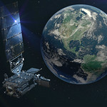
On May 11, 2022, NOAA shared the first images of the Western Hemisphere from its GOES-18 satellite. The satellite’s Advanced Baseline Imager (ABI) instrument recently captured stunning views of Earth.

GOES-18, NOAA’s newest geostationary satellite, launched on March 1. The ABI views Earth with sixteen different channels, each measuring energy at different wavelengths along the electromagnetic spectrum to obtain information about Earth’s atmosphere, land, and ocean.

Image of the United States using various instruments from GOES-18 Satellite.
This GOES-18 image shows the contiguous United States observed by each of the ABI’s 16 channels on May 5, 2022.

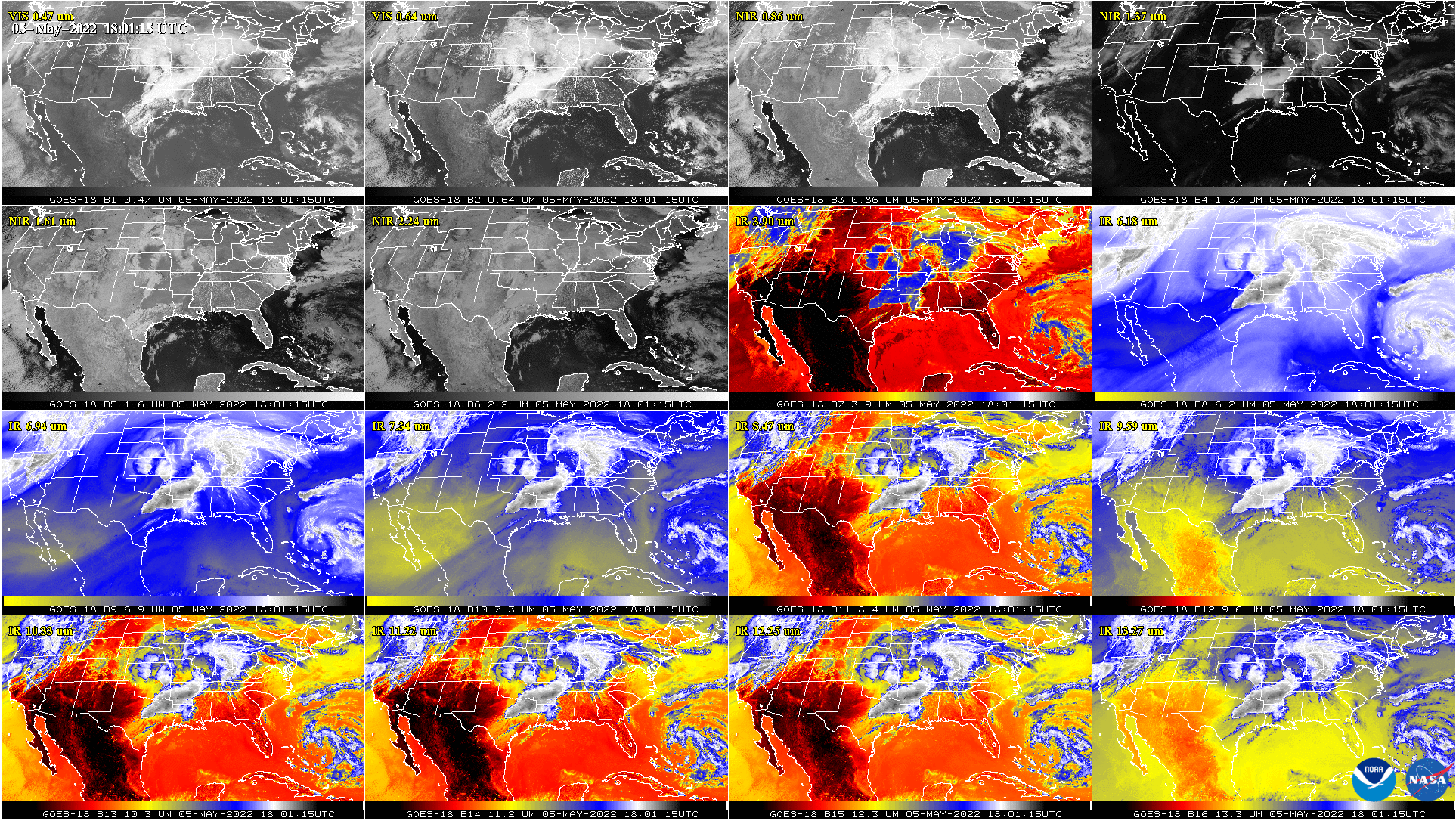
This 16-panel image shows the ABI’s two visible, four near-infrared and 10 infrared channels. The visible and near-IR bands are gray-colored, while the infrared bands have the warmer brightness temperatures mapped to warmer colors. The different appearance of each band is due to how each band reflects or absorbs radiation. Each spectral band was scanned at approximately the same time, starting at 18 UTC.

GOES-18 orbits 22,236 miles above the equator at the same speed the Earth rotates. This allows the satellite to constantly view the same area of the planet and track weather conditions and hazards as they happen. 

The ABI provides high-resolution imagery and atmospheric measurements for short-term forecasts and severe weather warnings. ABI data is also used for detecting and monitoring environmental hazards such as wildfires, dust storms, volcanic eruptions, turbulence, and fog.

Data from multiple ABI channels can be combined to create imagery that approximates what the human eye would see from space—a result known as GeoColor. Combining data from different channels in different ways also allows meteorologists to highlight features of interest.

Image of the Earth

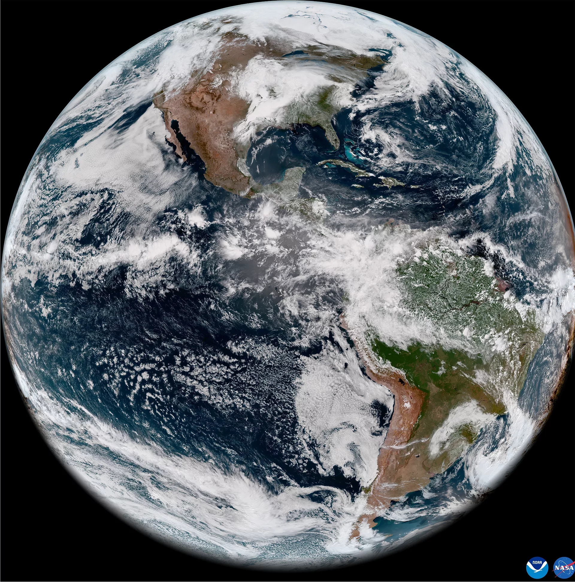
GOES-18 full disk GeoColor image from May 5, 2022. This type of imagery combines data from multiple ABI channels to approximate what the human eye would see from space. 

Recently, GOES-18 observed a number of weather events, environmental phenomena, and striking views of our planet. Storms across east Texas produced large hail, strong wind gusts, and tornadoes. Farther west in New Mexico, strong winds resulted in large areas of blowing dust and the expansion of large wildfires. Fog blanketed parts of Chile in South America, and clouds and some thunderstorms formed along with sea breezes in the Yucatan and south Florida. 

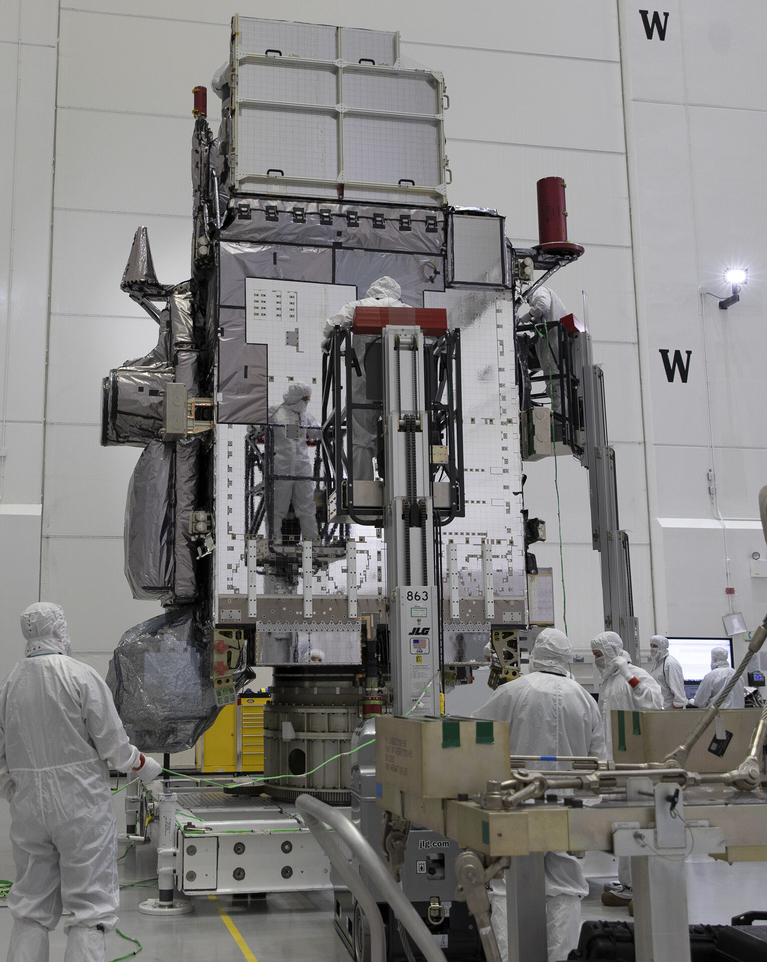
GOES-18 is currently undergoing post-launch testing, validation and calibration of its instruments and systems to prepare it for operations. The ABI cooling system is performing well, with no signs of the issue that affects its sister satellite, GOES-17. The ABI was redesigned for GOES-18 to reduce the likelihood of future cooling system anomalies. The new design uses a simpler hardware configuration that eliminates the filters that are susceptible to debris. 

On May 16, 2022 at 14:00 UTC, GOES-18 will commence a three-week drift from 89.5 degrees West to 136.8 degrees West. The destination is 0.4 degrees longitude from the operational GOES-West satellite (GOES-17) at 137.2 degrees West. Once arriving at 136.8 degrees West, on June 6, 2022 23:30 UTC GOES-18 will continue with its Post-Launch Test (PLT) checkout period.

GOES-18 Preparing for a new satellite

GOES-18 will assist GOES-17 with GOES West operations in late summer 2022 and again in early fall. NOAA plans for GOES-18 to replace GOES-17 as GOES West in early 2023. Imagery from GOES-18 during the post-launch testing phase should be considered preliminary and non-operational.

Article from NOAA/NESDIS May 11th 2022

Post navigation

❮ Previous Post: GOESRECV-PS
Next Post: GOES-18 HRIT- First Light Imagery ❯

You may also like

Satellites
GOES-15 is now EWS-G2
October 26, 2023
Interesting stuff you should know!
Who are Satellite Data and Imaging Enthusiasts?
February 22, 2023
Interesting stuff you should know!
Libera, a new instrument for JPSS NOAA-22
September 11, 2024
Satellites
GOES-T’s launch has been delayed to March 1, 2022.
October 1, 2021

Please, Help Support USRadioguy.com

If you like what I do please support me on Ko-fi, It really means a lot, every bit helps!

Hardware Humor Imagery Processing Interesting stuff you should know! Launch News Life News Product Review Satellites Science Software Space Weather Uncategorized VLOG

Alphabetical Listing of all Pages on site:

  • 36-Hour Imagery Processing script
  • 3D animation of realtime data
  • A PORTABLE WWII ERA “MORALE RADIO”
  • About Me
  • ADS-B Reception
  • Allsky Camera
  • AN/GRR-5 THE ANGRY 5
  • BD-71 Field Switch Board and EE-8B Field Telephones
  • Current GOES 16 & 18 False Color Satellite Imagery
  • Custom Color Lookup Table
  • Custom Imagery Scripts for GOES
  • Daily 3D view of Earth
  • Daily Global Composites
  • Decoding EWS-G1 or GOES-13
  • Drifting a geostationary satellite
  • DRONE FUN
  • Even the kitchen sink
  • GEO-RING COMPOSITES
  • GEO-SAT PI FRAME
  • Geo-stationary Satellite Imagery Reception
  • Global Weather Data
  • GOES 19&18 – Last 96 Hours of Imagery
  • GOES BAND IMAGERY
  • GOES GRB Reception
  • GOES receiving in Windows for SatDump
  • GOES-18 Preparing for a new satellite
  • GOES-R Series Multimedia Tour
  • GOES-U (19) Countdown to Launch
  • GOES16 A full year of received imagery
  • Ground Station Map
  • High Resolution Imagery
  • Home
  • House History
  • HRIT/EMWIN & GRB
  • HRPT Satellite Tracking and Capture
  • Hubble Space Telescope Data Processing
  • Inmarsat Decoding
  • Layering Fire and Hotspot Data on Meteor Sat Imagery
  • Layering Geo-Spatial Fire Data into Satellite Imagery
  • Mesoscale Imagery Defined
  • METEOR M2- Series
  • MODIS VIIRS Global Coverage
  • My Other Interests
  • NASA, NOAA, Military, GOVT dish, and tower stations.
  • National Hurricane Data
  • Newsletter terms & conditions
  • NOAA & Meteor APT and LRPT RECEPTION
  • Online Satellite Imagery and Information
  • Optimizing a WIFI Grid Antenna for Maximum Efficiency
  • ORBITAL DYNAMICS 101
  • Orbitron, Gpredict, and PSTRotator with new TLE format
  • PI Based Broadcastify Server
  • Pi Based Picture Frame
  • Presentations
  • Privacy Policy
  • Programming the PI for goestools operation
  • R-100/URR 1944 MORALE RADIO
  • RADIO SET SCR-284
  • Rare Captures
  • Receiving GOES 18,19 with goestools
  • Receiving GOES HRIT with SATDUMP
  • Receiving the Funcube Amateur Satellite
  • Satdump for Meteor and NOAA decoding
  • Satellite Finder
  • Satellite Frequencies
  • Satellite Ground Stations
  • Satellite Tracking
  • Security
  • SETEC Astronomy
  • Solar Power for PI
  • South America GOES 16
  • Space Weather
  • Stray Light Zone (SLZ)
  • Thanks!
  • The quest for True Color Imagery
  • Tried and Tested Hardware
  • Usradioguy Blogs
  • Usradioguy Merchandise
  • USRadioguy Newsletter
  • USRadioguy VLOGS
  • USRADIOGUY Youtube Page
  • VIBRATOR CONVERSION MODULE
  • Viterbi, R/S Errors, Packets
  • VS-3 VIBRATOR CONVERSION
  • What is RTL-SDR?
  • WWII Audio Page
  • WWII K-24 Aerial Camera
  • WWII RADIO
  • WxtoImg Fix
  • Zombie Satellites

Hardware Humor Imagery Processing Interesting stuff you should know! Launch News Life News Product Review Satellites Science Software Space Weather Uncategorized VLOG

Satellite And Weather Related Feeds

  • CIMSS Satellite Blog
  • USRadioguy.com
  • wildfires
  • NASA Earth Observatory
  • SPC Particularly Dangerous Situation (PDS) Tornado/Severe Thunderstorm Watch
  • satellites
  • Satellites News -- ScienceDaily
  • Satellite Liaison Blog
Trout Fire in New Mexico produces a pyrocumulonimbus cloud
Blowing dust in Argentina
Canadian wildfire smoke over Alaska
End Of Life for NOAA 15 and 19?….not so fast…
Vitality GOES
Vitality GOES
Decommissioning NOAA-18
The fire cycle
Unmasking the complicated chemistry of wildfire smoke: What's in it?
NOAA unveils powerful convergence of AI and science with revolutionary Next-Generation Fire System technology
Earth’s Clouds on the Move
Seasonal Breakup in the Amundsen Gulf
Egypt’s Mediterranean Coast
SPC PDS Severe Thunderstorm Watch 399
Five historically huge solar events
65 years since the world’s first weather satellite
Investing in America: NOAA's Science, Service and Stewardship in Action
Satellite measures CO2 and NO2 simultaneously from power plant emissions for the first time
Existing international law can help secure peace and security in outer space
Small, faint and 'unexpected in a lot of different ways': Astronomers make galactic discovery
Late-Season Atlantic Hurricane-Force Low
Atmospheric River Strikes Eastern U.S.
Another Week, Another Deep South Soaker
  • Facebook Geo Stationary Satellites
  • Usradioguy Facebook
  • Instagram
  • Reddit
  • Github
  • Linkedin

Copyright © 2025 USRadioguy.com - All Rights Reserved. All material protected by Fair Use Section 107 of the Copyright Act. This site is Verified and Secured with 256 bit SSL encryption