Skip to content
USRADIOGUY

USRadioguy.com

Welcome to USRadioguy.com – Unlocking the Potential of Software Defined Radio

  • Home
    • Home of USRadioguy
    • USRadioguy Newsletter
    • Tried and Tested Hardware
    • What is RTL-SDR?
    • Global Weather Data
  • Satellite Reception
    • Geo Stationary Satellites
      • Geo-stationary Satellite Imagery Reception
      • GOESTOOLS on the PI
      • Update Goestools for GOES 18,19
      • Receiving GOES with SatDump CLI Mode
      • GOES receiving in Windows for SatDump GUI
      • Decoding EWS-G1/EWS-G2
      • GOES GRB Reception WIP
      • Optimizing a WIFI Grid Antenna for Maximum Efficiency
    • APT Satellites
      • APT RECEPTION
      • Satdump for Meteor and NOAA decoding
      • METEOR M2- Series
      • WxtoImg Fix
      • Converting to new TLE format
      • Layering Fire and Hotspot Data on Meteor Sat Imagery
      • HRPT Satellite Tracking and Capture
    • Receiving Other Satellites
      • Inmarsat Decoding
      • Receiving the Funcube Amateur Satellite
    • User Maps and Dish Pointers
      • Satellite Dish Pointer
      • User Global Ground Station Maps
      • Usermap rendered with Cesium
      • Global Map of Govt Dish Stations
    • Satellite Details & Information
      • ORBITAL DYNAMICS 101
      • HRIT/EMWIN & GRB Defined
      • Mesoscale Imagery Defined
      • Viterbi, R/S Errors, Packets
      • GOES BAND IMAGERY
      • Stray Light Zone (SLZ)
      • Drifting a geostationary satellite
      • GOES-R Series Multimedia Tour
      • Online Satellite Imagery and Information
      • Satellite Frequencies
      • Solar and Space Weather
  • Satellite Imagery
    • IMAGERY- Current GOES East & West HRIT Satellite Imagery
    • IMAGERY- GOES 16&18 – Past 96 Hours of Imagery
    • High Resolution Imagery
    • Daily 3D view of Earth
    • NOAA APT Satellite imagery
    • PlanetMaker
    • GOES16 A full year of received imagery
  • Imagery Processing
    • Custom Color Lookup Table & Gradients
    • GOES-R Custom Imagery Scripts
    • Global geo-ring composites
    • MODIS VIIRS Global Coverage
    • 3D Satellite Tracking
    • The quest for True Color Imagery
    • 3D animation of realtime data
    • Layering Geo-Spatial Fire Data into Satellite Imagery
    • Orbital dynamics and the Moon
    • National Hurricane Data
  • News, VLOGS & BLOGS
    • News & USRadioguy Blogs
    • USRadioguy VLOGS
  • Project Lab
    • Orbital Information and Visualizations
      • Enhanced Planet Earth
      • Satellites in Orbit
      • Solar System
      • Objects in Orbit
    • Current Station Weather
      • Current Groundstation Weather
      • Global Weather Data
      • Space Weather
    • WWII RADIO
      • WWII K-24 Aerial Camera
      • WWII RADIO
      • RADIO SET SCR-284
      • VS-3 VIBRATOR CONVERSION
      • VIBRATOR CONVERSION MODULE
      • BD-71 Field Switch Board and EE-8B Field Telephones
      • R-100/URR 1944 MORALE RADIO
      • A PORTABLE WWII ERA “MORALE RADIO”
      • AN/GRR-5 THE ANGRY 5
      • WWII Audio Page
    • Raspberry Pi Projects
      • ADS-B Reception
      • Allsky Camera
      • Pi Based Picture Frame
      • PI Based Broadcastify Server
      • Solar Power for PI
    • Hubble Space Telescope Data Processing
    • Zombie Satellites
    • DRONES
  • About Me
    • About Usradioguy
      • SETEC Astronomy
    • Tried and Tested Hardware
    • Rare Captures
    • My Other Interests
    • Presentations
    • Merchandise
    • Privacy Policy
  • Home
  • Science
  • GOES-U Launch Day

GOES-U Launch Day

Posted on June 25, 2024July 10, 2024 By Carl
Launch News, News, Satellites, Science

Loading

Photo credit: NASA/Cory Huston

GOES-U Launch from Liftoff to Booster touchdown

NASA Video

GOES U Separation from Booster into Geo Transfer Orbit.

NASA video

NOAA’s latest weather satellite, GOES-U, blasted off on a SpaceX Falcon Heavy rocket Tuesday, June 25th at 17:16 EST from Kennedy Space Center in Florida. The powerful launch marks a new era for weather forecasting and space weather monitoring.

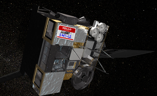
After a two-week journey, GOES-U will reach its designated geostationary orbit, 22,236 miles above Earth. Renamed GOES-19, it will undergo instrument checks before taking its position as the GOES-East satellite, replacing GOES-16 in mid-2025.

“GOES-U brings high-definition, speed, and precision to weather observation,” said NOAA Administrator Rick Spinrad. “This translates to more accurate and timely forecasts, with data critical for forecasters well into the 2030s.”

GOES-U carries a historic first: the CCOR-1, an operational satellite solar coronagraph. This instrument will work alongside other solar and space environment tools to detect potentially dangerous space weather that can disrupt power grids, communication, and navigation systems.

“This satellite is invaluable to our meteorologists and hydrologists,” said NOAA National Weather Service Director Ken Graham. “GOES-U expands our imaging capabilities for hurricanes, fires, and other life-threatening events. The new coronagraph will provide crucial lead time for geomagnetic storm warnings.”

GOES-U also completes the GOES-R series, a four-satellite program conceived over 20 years ago and expected to operate until the late 2030s. “These satellites provide fast, accurate data for tracking severe weather, wildfires, floods, and other hazards,” said Steve Volz, assistant administrator for NOAA’s Satellite and Information Service.

Working alongside GOES-18 in the GOES-West position, GOES-U will observe over half the globe, from Africa to New Zealand and Alaska to Antarctica. This enhanced coverage will significantly improve weather monitoring and forecasting capabilities for years to come.

.

NOAA/NESDIS
NOAA/NESDIS
NOAA/NESDIS
NOAA/NESDIS
NOAA/NESDIS
@johnpisaniphoto
NOAA Swag
Morning at eh Capre
The NOAA Social Crew!

Photos of Launch Prep and Port Canaveral

Live View from SpaceFlight Now:

GOES-U

Falcon Heavy | SpaceX

Kennedy Space Center, Florida, USA

Launch Pad LC-39A

Tue, Jun 25, 2024, 04:16 PM CDT

USRadioguy Timezone Converter
Select Launch Time and Date:
Select Your Time Zone:
Convert To Location:
Reset Convert Time

Graphic by spaceintel101.com

Details:

  • Launch Provider -SpaceX
  • Status: Active
  • Price: $97.0 million
  • Liftoff Thrust: 22,819 kN
  • Payload to LEO: 63,800 kg
  • Payload to GTO: 26,700 kg
  • Stages: 2
  • Side Thrusters: 2
  • Rocket Height: 70.0 m
  • Fairing Diameter: 5.2 m
  • Fairing Height: 13.0 m
CURRENTLY, NOAA IS ONLY DESIGNATING GOES-18 MESO 1 FOR 30 SECOND/1 MINUTE MESOSCALE IMAGERY FOR THE LAUNCH OF GOES-U THIS AFTERNOON. THIS WILL BE FOCUSED ON A CENTER POINT 50 NAUTICAL MILES FROM THE LAUNCH AT 29N/80W. IF A MESO IS ADDED TO GOES-16 I WILL POST IT HERE. REMEMBER, WHEN A HIGH RATE MESO OF 30 SECONDS OR 1 MINUTE IS ACTIVATED, THERE WILL BE NO SECOND MESO FROM THAT SATELLITE, SO NO MESO 2 DURING THAT TIMEFRAME.

PRODUCT(S) OR DATA IMPACTED: GOES-WEST MDS MESO-1 (30 SECONDS NON-ALTERNATING)
  • Requested Center Point: 29N/80W
  • Date/Time of Initial Impact: June 25, 2024 2100Z J/DAY 177
  • Date/Time of Expected End: June 26, 2024 0000Z J/DAY 178
  • Length of Event: 3 Hours
  • Requester: Satellite Analysis Branch
  • Priority: 5 National Event DSS/NSSE-SEAR/Radar Outage
  • Details/Specifics of Change: Monitoring conditions at and near the launch of GOES-U from Cape Canaveral.

*Special Note*

  • Normal case: 60 second Meso1 followed by alternate 60 second Meso 2
  • Non-alternating case: When a 30 second Meso 1 is requested, the alternate Meso 2 will not be produced during that time.

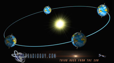
Where Is Geo Stationary Orbit?

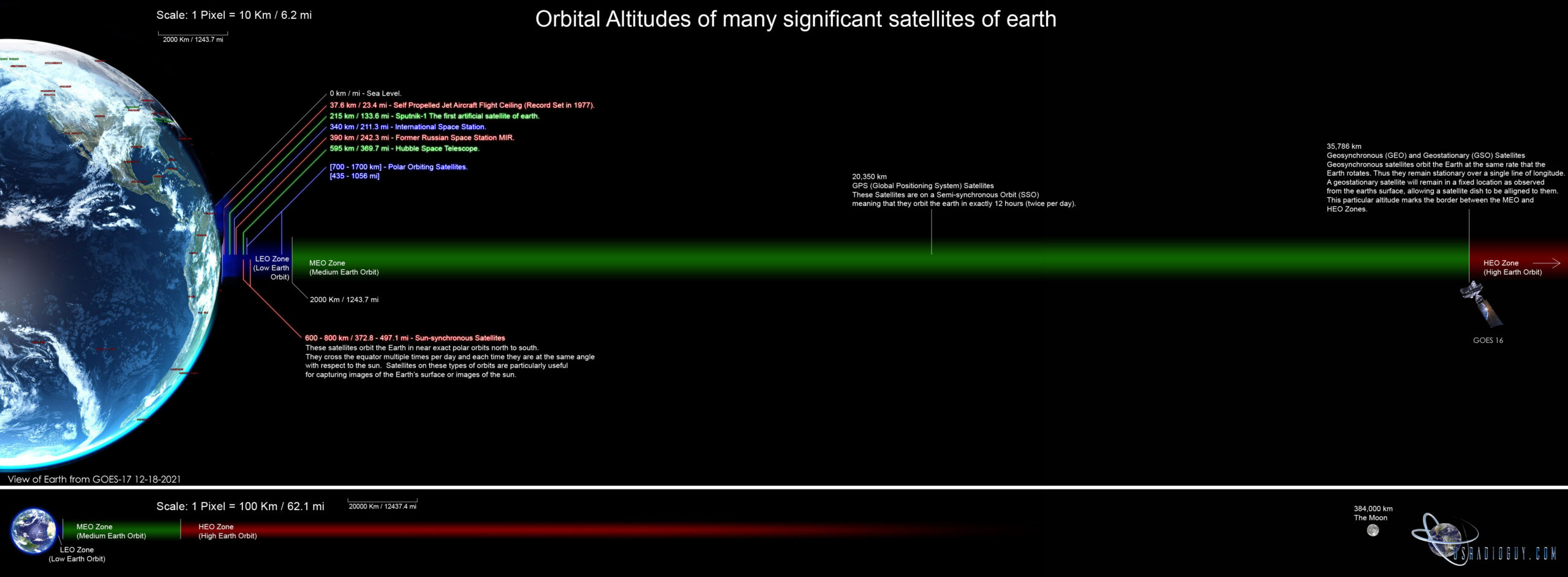
A Geo Transfer Orbit, also known as a Geosynchronous Transfer Orbit (GTO), is a highly elliptical orbit used to place satellites into geostationary orbit. Geostationary orbit is a special type of orbit around the Earth in which a satellite orbits the planet at the same rate as the Earth’s rotation. This means that the satellite appears to remain stationary relative to a fixed point on the Earth’s surface. The geostationary orbit is located at an altitude of approximately 35,786 kilometers (22,236 miles) above the Earth’s equator.

Launch vehicles typically cannot launch satellites directly into geostationary orbit because it requires too much energy. Instead, they launch the satellite into a GTO which is a more energy-efficient way to get the satellite close to its final destination.

Here’s how it works:

  1. The launch vehicle injects the satellite into an elliptical orbit with a low perigee (the closest point to Earth) and a high apogee (the farthest point from Earth) at an altitude of about 35,786 kilometers (22,236 miles).
  2. Once at apogee, the satellite’s on-board engine fires, circularizing the orbit and raising the perigee to match the apogee altitude. By using a SpaceX Falcon Heavy over the ULA Atlas , NASA was able to get GOES-U to a higher altitude, thus saving onboard fuel and extending the life of the mission by 5 years
  3. A second engine burn may be required to adjust the orbit’s inclination so the satellite travels exactly over the equator.

By using a GTO, satellites can conserve fuel and reach geostationary orbit efficiently. Many communication satellites, weather satellites, and Earth observation satellites use GTOs.

Tags: GOES-19 GOES-U

Post navigation

❮ Previous Post: GOES-U Launch Preparations
Next Post: Kraken Discovery Dish Progress ❯

You may also like

Satellites
Invited to present at SSEC CMISS
August 28, 2020
Satellites
GOES-15 is now EWS-G2
October 26, 2023
Interesting stuff you should know!
Who are Satellite Data and Imaging Enthusiasts?
February 22, 2023
Satellites
GOES-T Launch Photos
March 2, 2022

Please, Help Support USRadioguy.com

If you like what I do please support me on Ko-fi, It really means a lot, every bit helps!

Hardware Humor Imagery Processing Interesting stuff you should know! Launch News Life News Product Review Satellites Science Software Space Weather Uncategorized VLOG

Alphabetical Listing of all Pages on site:

  • 36-Hour Imagery Processing script
  • 3D animation of realtime data
  • A PORTABLE WWII ERA “MORALE RADIO”
  • About Me
  • ADS-B Reception
  • Allsky Camera
  • AN/GRR-5 THE ANGRY 5
  • BD-71 Field Switch Board and EE-8B Field Telephones
  • Current GOES 16 & 18 False Color Satellite Imagery
  • Custom Color Lookup Table
  • Custom Imagery Scripts for GOES
  • Daily 3D view of Earth
  • Daily Global Composites
  • Decoding EWS-G1 or GOES-13
  • Drifting a geostationary satellite
  • DRONE FUN
  • Even the kitchen sink
  • GEO-RING COMPOSITES
  • GEO-SAT PI FRAME
  • Geo-stationary Satellite Imagery Reception
  • Global Weather Data
  • GOES 19&18 – Last 96 Hours of Imagery
  • GOES BAND IMAGERY
  • GOES GRB Reception
  • GOES receiving in Windows for SatDump
  • GOES-18 Preparing for a new satellite
  • GOES-R Series Multimedia Tour
  • GOES-U (19) Countdown to Launch
  • GOES16 A full year of received imagery
  • Ground Station Map
  • High Resolution Imagery
  • Home
  • House History
  • HRIT/EMWIN & GRB
  • HRPT Satellite Tracking and Capture
  • Hubble Space Telescope Data Processing
  • Inmarsat Decoding
  • Layering Fire and Hotspot Data on Meteor Sat Imagery
  • Layering Geo-Spatial Fire Data into Satellite Imagery
  • Mesoscale Imagery Defined
  • METEOR M2- Series
  • MODIS VIIRS Global Coverage
  • My Other Interests
  • NASA, NOAA, Military, GOVT dish, and tower stations.
  • National Hurricane Data
  • Newsletter terms & conditions
  • NOAA & Meteor APT and LRPT RECEPTION
  • Online Satellite Imagery and Information
  • Optimizing a WIFI Grid Antenna for Maximum Efficiency
  • ORBITAL DYNAMICS 101
  • Orbitron, Gpredict, and PSTRotator with new TLE format
  • PI Based Broadcastify Server
  • Pi Based Picture Frame
  • Presentations
  • Privacy Policy
  • Programming the PI for goestools operation
  • R-100/URR 1944 MORALE RADIO
  • RADIO SET SCR-284
  • Rare Captures
  • Receiving GOES 18,19 with goestools
  • Receiving GOES HRIT with SATDUMP
  • Receiving the Funcube Amateur Satellite
  • Satdump for Meteor and NOAA decoding
  • Satellite Finder
  • Satellite Frequencies
  • Satellite Ground Stations
  • Satellite Tracking
  • Security
  • SETEC Astronomy
  • Solar Power for PI
  • South America GOES 16
  • Space Weather
  • Stray Light Zone (SLZ)
  • Thanks!
  • The quest for True Color Imagery
  • Tried and Tested Hardware
  • Usradioguy Blogs
  • Usradioguy Merchandise
  • USRadioguy Newsletter
  • USRadioguy VLOGS
  • USRADIOGUY Youtube Page
  • VIBRATOR CONVERSION MODULE
  • Viterbi, R/S Errors, Packets
  • VS-3 VIBRATOR CONVERSION
  • What is RTL-SDR?
  • WWII Audio Page
  • WWII K-24 Aerial Camera
  • WWII RADIO
  • WxtoImg Fix
  • Zombie Satellites

Hardware Humor Imagery Processing Interesting stuff you should know! Launch News Life News Product Review Satellites Science Software Space Weather Uncategorized VLOG

Satellite And Weather Related Feeds

  • CIMSS Satellite Blog
  • USRadioguy.com
  • wildfires
  • NASA Earth Observatory
  • SPC Particularly Dangerous Situation (PDS) Tornado/Severe Thunderstorm Watch
  • satellites
  • Satellites News -- ScienceDaily
  • Satellite Liaison Blog
Trout Fire in New Mexico produces a pyrocumulonimbus cloud
Blowing dust in Argentina
Canadian wildfire smoke over Alaska
End Of Life for NOAA 15 and 19?….not so fast…
Vitality GOES
Vitality GOES
Decommissioning NOAA-18
The fire cycle
Unmasking the complicated chemistry of wildfire smoke: What's in it?
NOAA unveils powerful convergence of AI and science with revolutionary Next-Generation Fire System technology
Earth’s Clouds on the Move
Seasonal Breakup in the Amundsen Gulf
Egypt’s Mediterranean Coast
SPC PDS Severe Thunderstorm Watch 399
Five historically huge solar events
65 years since the world’s first weather satellite
Investing in America: NOAA's Science, Service and Stewardship in Action
Satellite measures CO2 and NO2 simultaneously from power plant emissions for the first time
Existing international law can help secure peace and security in outer space
Small, faint and 'unexpected in a lot of different ways': Astronomers make galactic discovery
Late-Season Atlantic Hurricane-Force Low
Atmospheric River Strikes Eastern U.S.
Another Week, Another Deep South Soaker
  • Facebook Geo Stationary Satellites
  • Usradioguy Facebook
  • Instagram
  • Reddit
  • Github
  • Linkedin

Copyright © 2025 USRadioguy.com - All Rights Reserved. All material protected by Fair Use Section 107 of the Copyright Act. This site is Verified and Secured with 256 bit SSL encryption