![]()
UPDATE 07-31-2025
End of an Era: Decommissioning the Legacy POES Satellites
The National Oceanic and Atmospheric Administration (NOAA) has officially wrapped up End-of-Life (EOL) testing for NOAA-15 and NOAA-19, signaling the imminent decommissioning of these two venerable spacecraft. As the last operational platforms in the enduring NOAA Polar Operational Environmental Satellites (POES) constellation, their retirement marks a significant transition.
The final decommissioning schedule for the remaining POES constellation assets is as follows:
NOAA-19: August 19, 2025
NOAA-15: August 12, 2025
This is a 3-day reminder for the suspension of POES data (NOAA-15 and NOAA-19) to Users after June 16, 2025. NOAA-18 was decommissioned on June 6, 2025 at 1740 UTC.
Important Information Regarding POES Data Products and Direct Broadcast Services
This post provides crucial updates regarding the operational status of data products and direct broadcast services from the Polar-orbiting Operational Environmental Satellites (POES). The information comes to me, during a conversation with Office of Satellite and Product Operations NOAA Satellite Operations Facility Physical Scientist J. Jankot.
Advanced Picture Transmission (APT) and Low Resolution Picture Transmission (LRPT) services will continue until the decommissioning of the respective NOAA 15 and 19 POES satellites.
High Resolution Picture Transmission (HRPT) services will also continue until the decommissioning of the respective POES satellites..
However, please be advised that POES data products generated after June 15, 2025, are no longer approved for operational use. This critical notification applies to all users of Advanced Very High Resolution Radiometer (AVHRR) and APT direct broadcast data.
- AMSU-A1/A2/B – data will no longer be available after Jun 16, 2025 after 1800 UTC
- APT/LRPT – service will be left enabled, but do not use this service for operational use
- HRPT – service will be left enabled for diagnostic flight use only (no operational use)
- AVHRR – data will no longer be available after Jun 16, 2025 after 1800 UTC
- DCS/ADCS (Argos) – service will be left enabled as best effort only
- HIRS – data will no longer be available after Jun 16, 2025 after 1800 UTC
- SARR (SARSAT) – service will be left enabled as best effort only
- SEM – data will no longer be available after Jun 16, 2025 after 1800 UTC
- MHS – data will no longer be available after Jun 16, 2025 after 1800 UTC
- SBUV – data will no longer be available after Jun 16, 2025 after 1800 UTC
Clarification on AVHRR and HRPT:
- AVHRR: In this context, AVHRR refers specifically to the Global Area Coverage (GAC) data from which Level 1b AVHRR products are derived and distributed through the Product Distribution and Access (PDA) system. The processing and distribution of this GAC-based L1b AVHRR data will cease at the NOAA Satellite Operations Facility (NSOF).
- HRPT: HRPT encompasses the high-resolution version of the GAC data. This stream contains comprehensive instrument and spacecraft telemetry data accessible to direct broadcast users. Direct users are strongly advised against using HRPT data for operational purposes after the designated date, as the POES mission life cycle concludes. Notably, for Command and Data Acquisition (CDA) stations, the HRPT data transmitted via Radio Frequency (RF) is utilized in real-time for satellite tracking and spacecraft telemetry monitoring.
Click here for details- As for the decommissioning of NOAA 15 and 19. Not scheduled as of yet.
Between 2015 and 2021, four satellites—NOAA-16, NOAA-17, DMSP F11, and DMSP F13—experienced in-orbit breakups. Investigations, notably the 2023 NOAA-17 report, point to a violent rupture of the onboard Nickel-Cadmium (Ni-Cd) battery packs due to extreme overcharging as the probable cause.
Despite NOAA-16, NOAA-17, and DMSP F11 undergoing decommissioning, which includes disconnecting batteries from charging systems, the overcharging occurred. The NOAA-17 investigation theorized a potential electrical system fault that allowed inadvertent charging through a normally discharge-only pathway. This persistent design flaw risk prompted NOAA to decommission NOAA-18, given the known susceptibility of this spacecraft design to battery overcharging. With the loss of S-band as as the only method to verify command and control responses, the order was given to decommission NOAA 18. If NOAA and the subcontractor operating the satellites, determine that there is an issue with command and control, then I would imagine that the decommissioning of the last two satellites will occur, but as of now that has not happened.
UPDATE 06-06-2025
Based on NOAA’s requirement to responsibly manage on-orbit assets, NOAA will decommission NOAA-18 on June 6, 2025 at 1740 UTC CLICK HERE FOR DECOMMISIONING INFO
Based on NOAA’s requirement to responsibly manage on-orbit assets, NOAA will commence with decommissioning activities immediately for NOAA-18. The exact date/time of decommission is not yet determined, and is pending completion of pre-decommission processes. Users are advised to discontinue use of all NOAA-18 science products immediately.
NOAA has officially initiated the decommissioning activities for the NOAA-18 satellite. This process aims to safely remove the aging spacecraft from active service and mitigate any potential risks, such as the creation of orbital debris.
While the agency has begun the necessary steps, the precise date and time of the satellite’s full decommissioning are not yet finalized. This is contingent upon the successful completion of a series of “pre-decommission processes.” These preliminary steps typically involve:
- System Safing: Disconnecting batteries, disabling transmitters, and depleting propellants (like nitrogen gas) to make the satellite inert and prevent uncontrolled breakups.
- Data Transition: Ensuring that all critical data streams from NOAA-18 are successfully transferred to newer, more advanced satellite constellations, such as the Joint Polar Satellite System (JPSS). NOAA-18, along with NOAA-15 and NOAA-19, has been in an “Extended Life” program, transitioning to a commercial ground system for continued operation as “data of opportunity,” but this will cease.
- Operational Handover: Shifting any remaining operational responsibilities or data product generation to other active satellites or ground systems.
- Final Orbital Maneuvers (if applicable): While not always a de-orbit for end-of-life satellites like NOAA-18 (which will likely remain in orbit but be inert), some decommissioning processes might involve maneuvers to place the satellite in a safer, less congested orbital path.
- Compliance Checks: Verifying that all decommissioning procedures adhere to national and international guidelines for space debris mitigation.
The delay in setting an exact decommission date allows NOAA to meticulously execute these pre-decommissioning tasks, ensuring a smooth transition and minimizing any potential disruptions to weather forecasting and environmental monitoring services.
Please also note the NOAA-18 STX-4 S-band downlink transmitter (dropped from 7 Watts down to 0.8 Watts), that surfaced over the weekend (May 31), and is resulting in considerable imagery degradation. Users are advised to discontinue use of all NOAA-18 products immediately.
UPDATE 04/28/2025
Important Information Regarding POES Data Products and Direct Broadcast Services
This post provides crucial updates regarding the operational status of data products and direct broadcast services from the Polar-orbiting Operational Environmental Satellites (POES). The information comes to me today, during a conversation with Office of Satellite and Product Operations NOAA Satellite Operations Facility Physical Scientist J. Jankot.
Advanced Picture Transmission (APT) and Low Resolution Picture Transmission (LRPT) services will continue until the decommissioning of the respective POES satellites.
High Resolution Picture Transmission (HRPT) services will also continue until the decommissioning of the respective POES satellites..
However, please be advised that POES data products generated after June 15, 2025, are no longer approved for operational use. This critical notification applies to all users of Advanced Very High Resolution Radiometer (AVHRR) and APT direct broadcast data.
Clarification on AVHRR and HRPT:
- AVHRR: In this context, AVHRR refers specifically to the Global Area Coverage (GAC) data from which Level 1b AVHRR products are derived and distributed through the Product Distribution and Access (PDA) system. The processing and distribution of this GAC-based L1b AVHRR data will cease at the NOAA Satellite Operations Facility (NSOF).
- HRPT: HRPT encompasses the high-resolution version of the GAC data. This stream contains comprehensive instrument and spacecraft telemetry data accessible to direct broadcast users. Direct users are strongly advised against using HRPT data for operational purposes after the designated date, as the POES mission life cycle concludes. Notably, for Command and Data Acquisition (CDA) stations, the HRPT data transmitted via Radio Frequency (RF) is utilized in real-time for satellite tracking and spacecraft telemetry monitoring.
Update 04/25/2025
From NOAA Operations regarding NOAA 15, 18, and 19:
This is an important notification from NOAA Operations regarding the future of data from our long-serving Polar-orbiting Environmental Satellites (POES): NOAA-15, NOAA-18, and NOAA-19.
Please be advised that NOAA will officially end the delivery of all data from these three POES satellites on June 16, 2025, at 18:00 UTC.
- AMSU-A1/A2/B – data will no longer be available after Jun 16, 2025 after 1800 UTC
- APT/LRPT – service will be left enabled, but do not use this service for operational use
- HRPT – service will be left enabled for diagnostic flight use only (no operational use)
- AVHRR – data will no longer be available after Jun 16, 2025 after 1800 UTC
- DCS/ADCS (Argos) – service will be left enabled as best effort only
- HIRS – data will no longer be available after Jun 16, 2025 after 1800 UTC
- SARR (SARSAT) – service will be left enabled as best effort only
- SEM – data will no longer be available after Jun 16, 2025 after 1800 UTC
- MHS – data will no longer be available after Jun 16, 2025 after 1800 UTC
- SBUV – data will no longer be available after Jun 16, 2025 after 1800 UTC
In the interim, all users should make plans to discontinue use of POES data from NOAA-15, NOAA-18 and NOAA-19 as these data and services will no longer be made available after Jun 16, 2025 1800 UTC.
This means that after this date and time, the valuable streams of environmental information we’ve come to rely on from NOAA-15, NOAA-18, and NOAA-19 will no longer be available. This includes all raw data, processed products, and any related services. Factors involved include the natural aging and degradation of satellite instruments, fuel limitations, and the availability of newer, more advanced satellite constellations like the Joint Polar Satellite System (JPSS) which offer enhanced capabilities and data quality. This shift allows NOAA to focus its resources on these next-generation systems.
Further updates regarding POES will be provided as the June 16, 2025 date approaches.
Authors note from USRadioguy:
The operational approach for services like APT and HRPT will likely continue as it has since 2024, following a “data of opportunity” model. This means NOAA’s contractor will not actively work to fix failing systems.
Looking for Radio Gear?
Upgrade Your Radio Game: Must-Have Hardware!
Tired of weak signals and limited range? Or, Just want to get into the hobby? I’ve personally tested and rely on Nooelec hardware for my daily radio operations, tutorials, and demos – and the results speak for themselves. Ready to boost your radio experience? Check out my top recommendations below, featuring Nooelec, Raspberry Pi, RTL-SDR Blog, and other brands of essential gear. Don’t miss out on special offers and exclusive bundles!
Update 01/13/2025
From NOAA Operations regarding NOAA 15, 18, and19
As of today 01/13, the National Oceanic and Atmospheric Administration (NOAA) has not announced plans to decommission the NOAA-15 satellite or shut down the Advanced Very High Resolution Radiometer (AVHRR) instrument. However, the legacy Polar-orbiting Operational Environmental Satellite (POES) constellation, which includes NOAA-15, NOAA-18, and NOAA-19, is now considered “data of opportunity.” This means that NOAA will no longer manage the constellation as an operational product, and the commercial vendor is now responsible for data distribution and collection.
In simpler terms, NOAA-15 and the other legacy POES satellites are still operating, but they are no longer the primary source of data for NOAA’s weather and climate monitoring programs. Parsons Corporation is the contractor for data distribution and access for the legacy satellites.
This change does not mean that NOAA-15 and the other legacy POES satellites will no longer be useful. In fact, their data can still be used for research and other purposes. However, end users of this data should be aware that it is no longer being managed as an operational product by NOAA
The POES Satellite Operations will be transitioning off the existing NOAA POES Ground System to a Commercial Ground System service. The POES Constellation consists of NOAA-15, NOAA-18, and NOAA-19, now in an extended phase of their mission life, and will transition to this best-effort approach managed and operated by the new commercial ground system service. The operations transition period will span from May 1st 2023 until September 15th, 2023. As of November 28th, 2023, the POES Constellation formally transitioned to Extended Life (EL) operations for all 3 operational satellites (NOAA 15, 18, and 19). NOAA is no longer managing the legacy POES constellation as an operational product. As of 2024 plans were to continue legacy products on all three NOAA POE sats, 15,18,19. It is predicted that operational usage of the crafts will continue in private contractor hands past the Sept 25, 2025 contract deadline, and it has been approved in the preliminary NOAA operation budget.
Update 09/27/2023
The AVHRR/3 sensor on board NOAA 15 has repeatedly seized, and no other attempts will be made to recover the instrument. However, the spacecraft itself remains healthy and other subsystems remain active. Therefore, there is no plan for decommissioning the spacecraft at this time.
It is important to note that the spacecraft itself is still operational. Other sensors onboard NOAA 15 are still able to collect data, and this data will continue to be used for a variety of purposes, such as weather forecasting, climate research, and environmental monitoring.
In the meantime, NOAA 15 will continue to operate and collect data. The spacecraft is expected to remain in service for several more years. NOAA 18 and 19 are still operational, though all 3 spacecraft are in what is known as a POES EL (Extended Life) Program (See Below)
All data from all 3 POE satellites and now considered “data of opportunity.” This means that NOAA will no longer manage the constellation as an operational product, and the commercial vendor (Parsons Corporation) is now responsible for data distribution and collection.
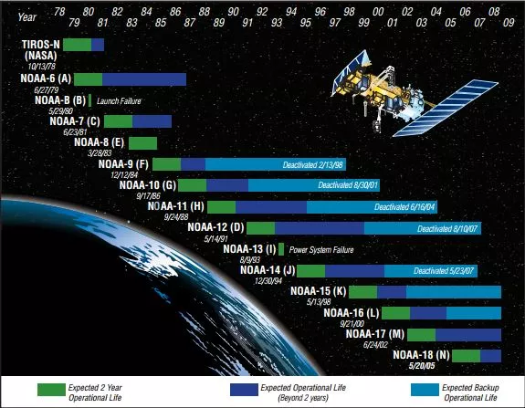
Life Expectancy
Each spacecraft was designed to meet all on-orbit performance requirements for a minimum
period of two years.
What is AVHRR?
The AVHRR/3 is a radiometer that measures the Earth’s outgoing radiation in six different wavelengths. Three of these wavelengths are in the visible and near-infrared region, and the other three are in the thermal infrared region. The thermal infrared channels are cooled to a very low temperature to make them more sensitive.
The AVHRR/3 uses a rotating mirror to scan across the Earth, and it takes a measurement every 1.1 kilometers (0.68 miles). The data from the six channels is sent to the spacecraft, and then to the ground.
Here is a more detailed explanation of some of the terms used in the text:
- Radiometer: A device that measures the amount of radiation coming from a particular object.
- Visible and near-infrared region: The part of the electromagnetic spectrum that we can see with our eyes, and the part that is just beyond the visible spectrum.
- Thermal infrared region: The part of the electromagnetic spectrum that is emitted by objects that are warm.
- Rotating mirror: A mirror that is attached to a motor and spins around.
- Spacecraft: A vehicle that travels through space.
- Ground: The surface of the Earth.

Now that all 3 NOAA birds have been designated as EOL in 2024 by NOAA, what does that mean for the operations of the sat in space? Does this mean that their time here on earth…. well, up above the earth, is over? Not exactly….
POES EL (Extended Life)
The new POES EL (Extended Life) program hopes to keep some life in the NOAA birds. This year, 2023, POES (NOAA 15,18,19) Satellite Operations are transitioning off the existing NOAA POES Ground System to a Commercial Ground System service. The Transition started on May 1st of this year and will be complete on Sept 15th.
POES data that was once operationally supported will migrate over to a data of opportunity service, as available. Due to this new approach, contingency data recovery will not be performed and extended data disruptions could occur periodically because of operational constraints.
Now what does “Data of Opportunity” mean? Well, if the satellite is putting out data it will be available, but, if a system fails, and cannot be restored easily, or cost-effectively, that data will no longer be available.
The new POES wrangler is Parsons Technology who won the $16 million dollar contract to keep the NOAA birds flying and ground control running. Parsons Leveraged its existing commercial capability which allowed them to send first vehicle commands within ~5 months of being on contract! They are also on schedule to assume Spacecraft Control Authority (SCA) shortly, enabling NOAA to repurpose their finite resources for other responsibilities.
NOAA’s three POES will be one of the first U.S. government satellites to transition from a legacy government-owned ground control system to a hybrid cloud-based commercial-based operation, setting a precedent that may lead to further commercialization of government-owned satellites in the future.
Over the next six months, the Parson’s team will move the control of the POES to commercial ground control systems deployed on a hybrid cloud architecture using Parsons’ commercial space software applications while demonstrating successful control of POES, followed by six months of full commercial operations.
Worst-case scenario – if one of the birds falters…ADC
NOAA is prepared for the worst-case scenario, with a software patch called Autonomous Decommissioning Control or ADC. This is the current working decommissioning plan.
How does ADC work?
If the ADC software finds a serious issue that will jeopardize the function or control of the satellite and its systems, and total failure of the satellite is imminent, ADC will execute a series of commands to safely decommission the satellite. Once installed, ADC functions in the background and requires no monitoring.
The triggers to execute the software are
- Regulated bus voltage over limit
- Regulated bus voltage under limit
- indicating that discharge is approaching capacity of batteries
- Battery temperature indicates “thermal run-away”
- Unrecoverable loss of attitude control
The ADC software was implemented on the remaining operational POES spacecraft as of:
- NOAA-15 as of Jun 29, 2020
- NOAA-18 as of Jun 9, 2021
- NOAA-19 as of Feb 10, 2021
Some of those commands would be to disconnect all battery charge paths, disable all transmitters, deplete nitrogen gas, and place the flight computers into an infinite loop. This would minimize any future potential breakup (or other catastrophic failure) that could add debris to the satellite’s orbit plane, which could compromise the operation of other crucial satellites.
Without ADV, normally, a ground-based, human operator would execute decommissioning actions for a satellite. However, the POES operators are able to communicate with each satellite only while it is visible over a ground site–a mere 10 to 15 minutes during the satellite’s full, 101-minute orbit of the Earth. This short window of time might not be sufficient for operators to execute end-of-life commands. Therefore, ADC runs continuously to monitor and execute final decommissioning at any time should fatal conditions arise.
Why Implement ADC? The NOAA-16 Incident
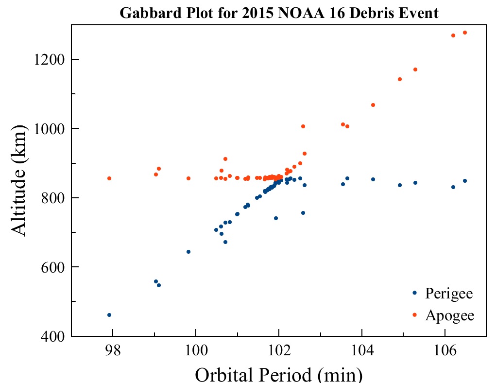
Things break. The Automatic Picture Transmission (APT) of NOAA-16 became inoperable due to sensor degradation on 15 November 2000. 4 years later, in early June 2014, the NOAA-16 satellite experienced a severe overvoltage, and its self-correcting backup system failed. On June 6, 2014 the signal from the satellite was lost after a major spacecraft anomaly. Space Ops detected a large spread of debris in orbits ranging from 462 by 858 to 829 by 1,278 Kilometers. This indicates that the debris were liberated, or as SpaceX calls them now, R.U.D. (Rapid Unscheduled Disassembly) with significant energy, suggesting either an onboard explosion or a collision between objects. A collision had been ruled out earlier leaving only the scenario of an explosion onboard the satellite which is not unheard of in NOAA satellites.
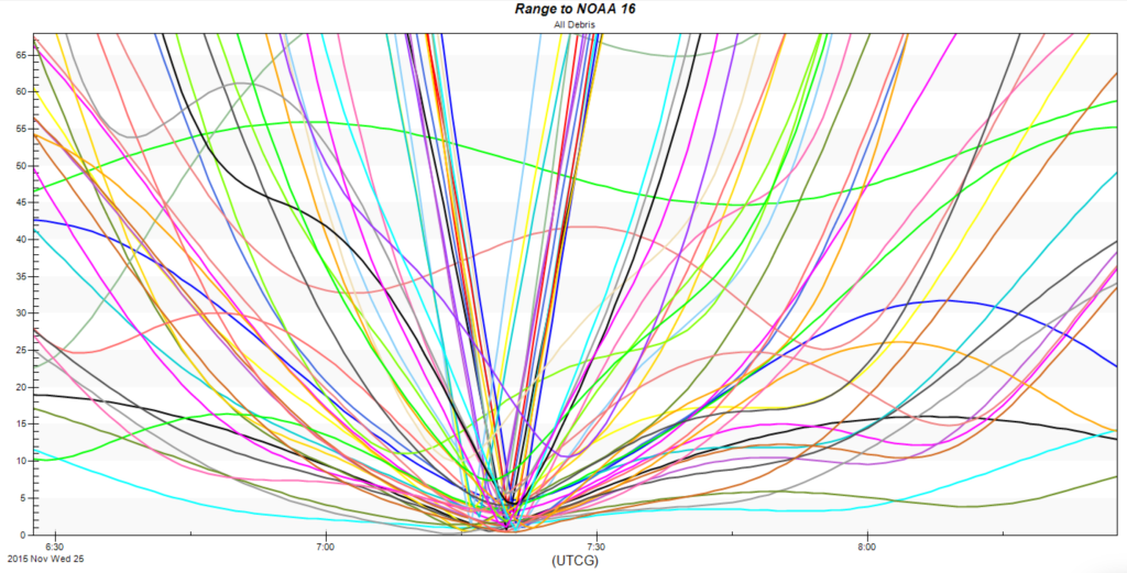
NOAA 16 was officially decommissioned on June 9 after it was determined that recovery of the mission was not possible. Over the course of its 13-year service life, NOAA 16 made 70,655 orbits around Earth, surpassing its three-year design life by a decade. The debris event was detected on November 25 2015 when ground-based radars sensed a number of debris in the vicinity of the NOAA 16 satellite that had been retired since 2014. Given the behavior of satellites of similar construction, the leading suspect for the debris event is an explosion of the spacecraft battery. NOAA-16 satellite broke apart 18 months after the initial overvoltage, which created a debris field of over 200 objects.
The Kessler Syndrome
Read more on what happens when satellites explode or collide The Kessler Syndrome
The Final Report on one of the other major NOAA Satellite Breakups, NOAA 17.
NOAA-17 Spacecraft Breakup and Investigation
In 2013 NOAA-17 was decommissioned. On March 10, 2021, the NOAA-17 spacecraft broke up, creating approximately 100 trackable pieces of debris. This incident follows similar breakups of other spacecraft, including NOAA-16, DMSP F11, and DMSP F13, which produced between 80 and 500 trackable objects each.
On March 15, 2021 NOAA’s Assistant Administrator for Satellite and Information Services, Dr. Stephen Volz, was notified of an on-orbit breakup of NOAA-17. The break-up was detected on 10 March 2021 by the US Space Force Space Surveillance Network and communicated through the NASA Orbital Debris Program Office on 12 March 2021.
To understand the cause of the NOAA-17 breakup and to prevent future occurrences, an investigation was launched. The NOAA-17 Break-up Engineering Investigation Board (EIB) was formed at the request of NOAA’s National Environmental Satellite, Data, and Information Service (NESDIS) and NASA’s Science Mission Directorate (SMD).
The EIB began its work on June 14, 2021, and released its findings and recommendations on August 20, 2021. The investigation aimed to determine the factors that led to the breakup and to suggest improvements in the operation and decommissioning of spacecraft to minimize the risk of similar events in the future.