Skip to content
USRADIOGUY

USRadioguy.com

Welcome to USRadioguy.com – Unlocking the Potential of Software Defined Radio

  • Home
    • Home of USRadioguy
    • USRadioguy Newsletter
    • Tried and Tested Hardware
    • What is RTL-SDR?
    • Global Weather Data
  • Satellite Reception
    • Geo Stationary Satellites
      • Geo-stationary Satellite Imagery Reception
      • GOESTOOLS on the PI
      • Update Goestools for GOES 18,19
      • Receiving GOES with SatDump CLI Mode
      • GOES receiving in Windows for SatDump GUI
      • Decoding EWS-G1/EWS-G2
      • GOES GRB Reception WIP
      • Optimizing a WIFI Grid Antenna for Maximum Efficiency
    • APT Satellites
      • APT RECEPTION
      • Satdump for Meteor and NOAA decoding
      • METEOR M2- Series
      • WxtoImg Fix
      • Converting to new TLE format
      • Layering Fire and Hotspot Data on Meteor Sat Imagery
      • HRPT Satellite Tracking and Capture
    • Receiving Other Satellites
      • Inmarsat Decoding
      • Receiving the Funcube Amateur Satellite
    • User Maps and Dish Pointers
      • Satellite Dish Pointer
      • User Global Ground Station Maps
      • Usermap rendered with Cesium
      • Global Map of Govt Dish Stations
    • Satellite Details & Information
      • ORBITAL DYNAMICS 101
      • HRIT/EMWIN & GRB Defined
      • Mesoscale Imagery Defined
      • Viterbi, R/S Errors, Packets
      • GOES BAND IMAGERY
      • Stray Light Zone (SLZ)
      • Drifting a geostationary satellite
      • GOES-R Series Multimedia Tour
      • Online Satellite Imagery and Information
      • Satellite Frequencies
      • Solar and Space Weather
  • Satellite Imagery
    • IMAGERY- Current GOES East & West HRIT Satellite Imagery
    • IMAGERY- GOES 16&18 – Past 96 Hours of Imagery
    • High Resolution Imagery
    • Daily 3D view of Earth
    • NOAA APT Satellite imagery
    • PlanetMaker
    • GOES16 A full year of received imagery
  • Imagery Processing
    • Custom Color Lookup Table & Gradients
    • GOES-R Custom Imagery Scripts
    • Global geo-ring composites
    • MODIS VIIRS Global Coverage
    • 3D Satellite Tracking
    • The quest for True Color Imagery
    • 3D animation of realtime data
    • Layering Geo-Spatial Fire Data into Satellite Imagery
    • Orbital dynamics and the Moon
    • National Hurricane Data
  • News, VLOGS & BLOGS
    • News & USRadioguy Blogs
    • USRadioguy VLOGS
  • Project Lab
    • Orbital Information and Visualizations
      • Enhanced Planet Earth
      • Satellites in Orbit
      • Solar System
      • Objects in Orbit
    • Current Station Weather
      • Current Groundstation Weather
      • Global Weather Data
      • Space Weather
    • WWII RADIO
      • WWII K-24 Aerial Camera
      • WWII RADIO
      • RADIO SET SCR-284
      • VS-3 VIBRATOR CONVERSION
      • VIBRATOR CONVERSION MODULE
      • BD-71 Field Switch Board and EE-8B Field Telephones
      • R-100/URR 1944 MORALE RADIO
      • A PORTABLE WWII ERA “MORALE RADIO”
      • AN/GRR-5 THE ANGRY 5
      • WWII Audio Page
    • Raspberry Pi Projects
      • ADS-B Reception
      • Allsky Camera
      • Pi Based Picture Frame
      • PI Based Broadcastify Server
      • Solar Power for PI
    • Hubble Space Telescope Data Processing
    • Zombie Satellites
    • DRONES
  • About Me
    • About Usradioguy
      • SETEC Astronomy
    • Tried and Tested Hardware
    • Rare Captures
    • My Other Interests
    • Presentations
    • Merchandise
    • Privacy Policy
  • Home
  • Satellites
  • GOES-15 is now EWS-G2

GOES-15 is now EWS-G2

Posted on October 26, 2023October 26, 2023 By Carl
Satellites

Loading

GOES-15 to become EWS-G2

Update 10/26/2023

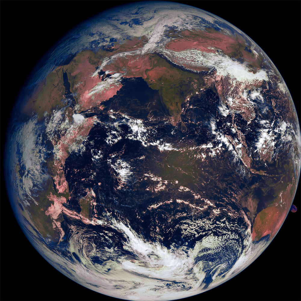
Krzysztof Preś recently captured this image from the former GOES15 sat, currently named EWS-G2, using a Helix 1.9m dish, VLNA, BladeRF 2.0 micro aX4 and satdump as the decoding/ processing software. The sat is located over the Indian Ocean currently at EWS-G2 is 69.88E. Note in the lower SE position on the limb of the earth the moon is visible!

Space Force accepts a second weather satellite through NOAA partnership

  • Published Sept. 22, 2023
  • By SAF/PA Staff Writer
  • Secretary of the Air Force

ARLINGTON, Va. (AFNS) —  

The U.S. Space Force accepted the transfer of a second geostationary weather satellite from the National Oceanic and Atmospheric Administration to extend persistent weather coverage of the Indian Ocean region until the 2030 timeframe. 

Through the Electro-optical Infrared Weather System-Geostationary mission, governed by partnership agreements between the Department of the Air Force and NOAA, the Space Force uses a residual NOAA Geostationary Operational Environmental Satellite to collect cloud imagery and perform environmental reconnaissance over the Indian Ocean region.

The partnership is a cost-effective solution, delivering mission-critical weather data to the joint force. Accurate weather data is essential for planning and execution of air, land, and maritime military operations.

“EWS-G is a prime example of innovation and the leveraging of partnerships,” said Lt Col Joseph L. Maguadog, Space System Command’s EO/IR Weather System Program Office materiel leader. “The repurposing of GOES-15 and residual NOAA ground equipment accomplished the mission at a fraction of the procurement cost of a brand-new system.”

The first EWS-G spacecraft transferred from NOAA, referred to as EWS-G1, has performed its role since September 2020. Based on remaining fuel estimates, the spacecraft is projected to reach its end of service life in February 2024.

While the Space Force is exploring long-term solutions for persistent weather coverage in the region beyond 2030, the service required a replacement to succeed EWS-G1 and asked NOAA to evaluate the possibility of transferring a second residual satellite.

After NOAA’s new GOES-18 became operational in January 2023 and congressional approval for the transfer was received in June, the Space Force accepted GOES-15 and the satellite was re-designated EWS-G2.

The second spacecraft is currently drifting towards the Indian Ocean region and will reach its assigned orbital location in November 2023.

EWS-G2 will continue to use an existing Remote Ground Station in Western Australia put in place in 2020 to support the EWS-G mission. As it currently does with EWS-G1, NOAA will operate EWS-G2 on behalf of the Space Force from the NOAA Satellite Operations Facility in Suitland, Maryland, and Wallops Command and Data Acquisition Station in Wallops Island, Virginia.


GOES-15 to become EWS-G2

October 26, 2023

Recently, Matt Seybold, GOES-R Data Ops Manager, PRO Team Lead, announced on March 15th during the Quarterly Joint GRB/HRIT/EMWIN meeting* that GOES-15 will be transferred to the United States Space Force as EWS-G2.

Update May 13, 2023 GOES-15: Currently drifting to Indian Ocean theater. Following arrival and checkout, it will become EWS-G2 (Source: NOAA NESDIS GOES DCS Spacecraft and Ground System Overview Technical Working Group, April 2023)

A brief History of GOES-15:

GOES-15 was launched atop a Delta IV-M+(4,2) rocket flying from Space Launch Complex 37B at the Cape Canaveral Air Force Station. The launch occurred at 23:57 UTC on 4 March 2010, forty minutes into a sixty-minute launch window. Upon reaching geostationary orbit on 16 March, it was redesignated GOES-15. On 6 December 2011, it was activated as the GOES-West satellite, replacing GOES-11.

NOAA began to transition GOES-15 out of operational status at the GOES-West position in late 2018 to replace it with GOES-17. On March 2, 2020, GOES-15 was deactivated and moved to a storage orbit, it has been reactivated several times as a backup to GOES-17 during certain times of the year. Because of its oxidizer and fuel mass being higher than GOES-14, it became the logical choice to become EWS-G2. EWS-G2 will support GVAR Imagery only.

Similar to EWS-G1 (GOES-13), The Electro-Optical Infrared Weather System – Geostationary 2, or EWS-G2 satellite will collect cloud imagery to enable fielded forces to perform environmental reconnaissance and cloud characterization over the Indian Ocean (IO) region. For the Department of Defense, this information is critical to the preparation of operational and tactical level plans and courses of action in the IO Area of Responsibility (AOR). Data are instrumental for assessing and predicting the feasibility of certain types of air and surface missions, anticipating the effectiveness of platforms/weapons systems and munitions, determining optimal times and locations for conducting operations and evaluating logistical, survivability, protection, and quality-of-life requirements.

GOES-15 will commence drifting operations no earlier than April 2023. Lt. Col. Joseph L. Maguadog, who directs the EWS program, said Jan. 9 at the American Meteorological Society annual meeting “We’re in discussions with our NOAA partners about utilizing another GOES satellite to succeed that first capability.” Currently, the orbital position** of EWS-G2 is anticipated to be located over the Indian Ocean, perhaps as a direct replacement for EWS-G1 (GOES-13). The drift maneuver and check-out is expected to take 2-3 months.

After the relocation maneuver, NOAA and the U.S. Space Force will complete a thorough checkout of the EWS-G2 spacecraft and sensors.

A Memorandum of Agreement (MOA) dictates the cooperation on the GOES IO Relocation Plan which will transfer the GOES- 15 spacecraft to the USSF for ownership, operations, and sustainment to extend the coverage that EWS-G1 currently provides until a more long-term solution can be acquired. Satellite Control Authority (SCA) will reside with Space Delta 2 (DEL 2) and is delegated to the 19th Space Defense Squadron, Operating Location-Alpha (OL-A), located at the NSOF, for oversight of both the EWS-G1 and EWS-G2 satellite. EWS-G sustainment is provided by the USSF Space Systems Command (SSC) at Los Angeles SFB, CA.

NOAA will continue to operate EWS-G1 and EWS-G2 on the behalf of the US Space Force from the NOAA Satellite Operations Facility in Suitland, Maryland as well as the Wallops Command and Data Collection Station in Virginia.

For North and south American Coverages, GOES-17 will be the Primary backup to GOES 16 and 18; While GOES-14 will be backup to GOES-17.

For a GOES-16/18 (East/West) anomaly, GOES-17 will be activated.  If it is a warm season for the GOES-17 ABI loop heat pipe anomaly, then GOES-14 will also be activated in series after GOES-17. Field users leveraging smaller antennas (~5m) will not be able to simultaneously downlink GOES-17 GRB and GOES-14 GVAR due to interference because GRB will dominate the signal.


* Link to Quarterly Joint GRB/HRIT/EMWIN meeting at bottom of that page.

** Orbital positional information will be added to this article when the exact location is released.

Recent Posts

  • End Of Life for NOAA 15,18,19?….not so fast…
  • GOES-19 now GOES-EAST
  • GOES 19 Operational Schedule
  • Update – Goes 16 to19 Transition to Operations
  • GOES-19 CCOR-1 Coronagraph Preliminary Non Operational Data
Tags: EWS-G2 GOES-15

Post navigation

❮ Previous Post: Goestools for Windows
Next Post: Hunga Tonga Eruption ❯

You may also like

News
Life after GOES, The GEO XO mission
January 25, 2024
Satellites
Vitality GOES
January 27, 2023
Satellites
OIG reccomends changes to NOAA GOES launch schedule/storage
January 26, 2022
Hardware
Kraken Discovery Dish Progress
June 28, 2024

Please, Help Support USRadioguy.com

If you like what I do please support me on Ko-fi, It really means a lot, every bit helps!

Hardware Humor Imagery Processing Interesting stuff you should know! Launch News Life News Product Review Satellites Science Software Space Weather Uncategorized VLOG

Alphabetical Listing of all Pages on site:

  • 36-Hour Imagery Processing script
  • 3D animation of realtime data
  • A PORTABLE WWII ERA “MORALE RADIO”
  • About Me
  • ADS-B Reception
  • Allsky Camera
  • AN/GRR-5 THE ANGRY 5
  • BD-71 Field Switch Board and EE-8B Field Telephones
  • Current GOES 16 & 18 False Color Satellite Imagery
  • Custom Color Lookup Table
  • Custom Imagery Scripts for GOES
  • Daily 3D view of Earth
  • Daily Global Composites
  • Decoding EWS-G1 or GOES-13
  • Drifting a geostationary satellite
  • DRONE FUN
  • Even the kitchen sink
  • GEO-RING COMPOSITES
  • GEO-SAT PI FRAME
  • Geo-stationary Satellite Imagery Reception
  • Global Weather Data
  • GOES 19&18 – Last 96 Hours of Imagery
  • GOES BAND IMAGERY
  • GOES GRB Reception
  • GOES receiving in Windows for SatDump
  • GOES-18 Preparing for a new satellite
  • GOES-R Series Multimedia Tour
  • GOES-U (19) Countdown to Launch
  • GOES16 A full year of received imagery
  • Ground Station Map
  • High Resolution Imagery
  • Home
  • House History
  • HRIT/EMWIN & GRB
  • HRPT Satellite Tracking and Capture
  • Hubble Space Telescope Data Processing
  • Inmarsat Decoding
  • Layering Fire and Hotspot Data on Meteor Sat Imagery
  • Layering Geo-Spatial Fire Data into Satellite Imagery
  • Mesoscale Imagery Defined
  • METEOR M2- Series
  • MODIS VIIRS Global Coverage
  • My Other Interests
  • NASA, NOAA, Military, GOVT dish, and tower stations.
  • National Hurricane Data
  • Newsletter terms & conditions
  • NOAA & Meteor APT and LRPT RECEPTION
  • Online Satellite Imagery and Information
  • Optimizing a WIFI Grid Antenna for Maximum Efficiency
  • ORBITAL DYNAMICS 101
  • Orbitron, Gpredict, and PSTRotator with new TLE format
  • PI Based Broadcastify Server
  • Pi Based Picture Frame
  • Presentations
  • Privacy Policy
  • Programming the PI for goestools operation
  • R-100/URR 1944 MORALE RADIO
  • RADIO SET SCR-284
  • Rare Captures
  • Receiving GOES 18,19 with goestools
  • Receiving GOES HRIT with SATDUMP
  • Receiving the Funcube Amateur Satellite
  • Satdump for Meteor and NOAA decoding
  • Satellite Finder
  • Satellite Frequencies
  • Satellite Ground Stations
  • Satellite Tracking
  • Security
  • SETEC Astronomy
  • Solar Power for PI
  • South America GOES 16
  • Space Weather
  • Stray Light Zone (SLZ)
  • Thanks!
  • The quest for True Color Imagery
  • Tried and Tested Hardware
  • Usradioguy Blogs
  • Usradioguy Merchandise
  • USRadioguy Newsletter
  • USRadioguy VLOGS
  • USRADIOGUY Youtube Page
  • VIBRATOR CONVERSION MODULE
  • Viterbi, R/S Errors, Packets
  • VS-3 VIBRATOR CONVERSION
  • What is RTL-SDR?
  • WWII Audio Page
  • WWII K-24 Aerial Camera
  • WWII RADIO
  • WxtoImg Fix
  • Zombie Satellites

Hardware Humor Imagery Processing Interesting stuff you should know! Launch News Life News Product Review Satellites Science Software Space Weather Uncategorized VLOG

Satellite And Weather Related Feeds

  • CIMSS Satellite Blog
  • USRadioguy.com
  • wildfires
  • NASA Earth Observatory
  • SPC Particularly Dangerous Situation (PDS) Tornado/Severe Thunderstorm Watch
  • satellites
  • Satellites News -- ScienceDaily
  • Error
Using Polar2grid and Direct Broadcast files to create imagery
Cirrus over the western Great Lakes
Wildfire in Saskatchewan produces a pyrocumulonimbus cloud
End Of Life for NOAA 15,18,19?….not so fast…
GOES-19 now GOES-EAST
GOES 19 Operational Schedule
The fire cycle
March was nation's 6th warmest on record
Podcast: Could the LA Wildfires harm California's marine life?
Mapping the Tiny Plankton That Feed Giant Right Whales
Lights of Southeast Asia
The Arches That Salt Built
SPC PDS Tornado Watch 98
Five historically huge solar events
65 years since the world’s first weather satellite
Investing in America: NOAA's Science, Service and Stewardship in Action
Satellite measures CO2 and NO2 simultaneously from power plant emissions for the first time
Existing international law can help secure peace and security in outer space
Small, faint and 'unexpected in a lot of different ways': Astronomers make galactic discovery

RSS Error: WP HTTP Error: cURL error 28: Connection timed out after 10003 milliseconds

  • Facebook Geo Stationary Satellites
  • Usradioguy Facebook
  • Instagram
  • Reddit
  • Github
  • Linkedin

Copyright © 2025 USRadioguy.com - All Rights Reserved. All material protected by Fair Use Section 107 of the Copyright Act. This site is Verified and Secured with 256 bit SSL encryption