Skip to content
USRADIOGUY

USRadioguy.com

Welcome to USRadioguy.com – Unlocking the Potential of Software Defined Radio

  • Home
    • Home of USRadioguy
    • USRadioguy Newsletter
    • Tried and Tested Hardware
    • What is RTL-SDR?
    • Global Weather Data
  • Satellite Reception
    • Geo Stationary Satellites
      • Geo-stationary Satellite Imagery Reception
      • GOESTOOLS on the PI
      • Update Goestools for GOES 18,19
      • Receiving GOES with SatDump CLI Mode
      • GOES receiving in Windows for SatDump GUI
      • Decoding EWS-G1/EWS-G2
      • GOES GRB Reception WIP
      • Optimizing a WIFI Grid Antenna for Maximum Efficiency
    • APT Satellites
      • APT RECEPTION
      • Satdump for Meteor and NOAA decoding
      • METEOR M2- Series
      • WxtoImg Fix
      • Converting to new TLE format
      • Layering Fire and Hotspot Data on Meteor Sat Imagery
      • HRPT Satellite Tracking and Capture
    • Receiving Other Satellites
      • Inmarsat Decoding
      • Receiving the Funcube Amateur Satellite
    • User Maps and Dish Pointers
      • Satellite Dish Pointer
      • User Global Ground Station Maps
      • Usermap rendered with Cesium
      • Global Map of Govt Dish Stations
    • Satellite Details & Information
      • ORBITAL DYNAMICS 101
      • HRIT/EMWIN & GRB Defined
      • Mesoscale Imagery Defined
      • Viterbi, R/S Errors, Packets
      • GOES BAND IMAGERY
      • Stray Light Zone (SLZ)
      • Drifting a geostationary satellite
      • GOES-R Series Multimedia Tour
      • Online Satellite Imagery and Information
      • Satellite Frequencies
      • Solar and Space Weather
  • Satellite Imagery
    • IMAGERY- Current GOES East & West HRIT Satellite Imagery
    • IMAGERY- GOES 16&18 – Past 96 Hours of Imagery
    • High Resolution Imagery
    • Daily 3D view of Earth
    • NOAA APT Satellite imagery
    • PlanetMaker
    • GOES16 A full year of received imagery
  • Imagery Processing
    • Custom Color Lookup Table & Gradients
    • GOES-R Custom Imagery Scripts
    • Global geo-ring composites
    • MODIS VIIRS Global Coverage
    • 3D Satellite Tracking
    • The quest for True Color Imagery
    • 3D animation of realtime data
    • Layering Geo-Spatial Fire Data into Satellite Imagery
    • Orbital dynamics and the Moon
    • National Hurricane Data
  • News, VLOGS & BLOGS
    • News & USRadioguy Blogs
    • USRadioguy VLOGS
  • Project Lab
    • Orbital Information and Visualizations
      • Enhanced Planet Earth
      • Satellites in Orbit
      • Solar System
      • Objects in Orbit
    • Current Station Weather
      • Current Groundstation Weather
      • Global Weather Data
      • Space Weather
    • WWII RADIO
      • WWII K-24 Aerial Camera
      • WWII RADIO
      • RADIO SET SCR-284
      • VS-3 VIBRATOR CONVERSION
      • VIBRATOR CONVERSION MODULE
      • BD-71 Field Switch Board and EE-8B Field Telephones
      • R-100/URR 1944 MORALE RADIO
      • A PORTABLE WWII ERA “MORALE RADIO”
      • AN/GRR-5 THE ANGRY 5
      • WWII Audio Page
    • Raspberry Pi Projects
      • ADS-B Reception
      • Allsky Camera
      • Pi Based Picture Frame
      • PI Based Broadcastify Server
      • Solar Power for PI
    • Hubble Space Telescope Data Processing
    • Zombie Satellites
    • DRONES
  • About Me
    • About Usradioguy
      • SETEC Astronomy
    • Tried and Tested Hardware
    • Rare Captures
    • My Other Interests
    • Presentations
    • Merchandise
    • Privacy Policy
  • Home
  • Science
  • Steady as she GOES
GPS positioning on board GOES

Steady as she GOES

Posted on July 9, 2024July 30, 2024 By Carl
Hardware, Interesting stuff you should know!, News, Satellites, Science

Loading

Keeping GOES-R steady:

Updated 07/09/2024
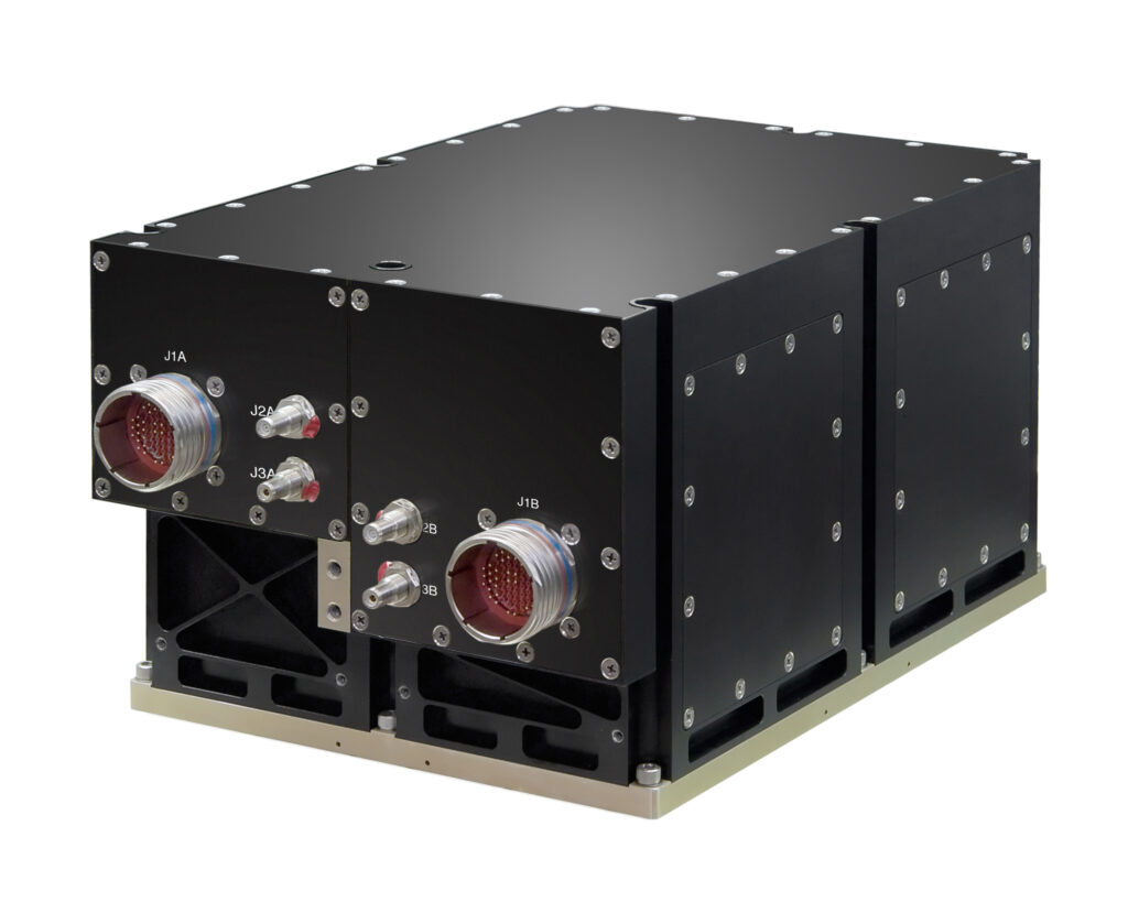
The GOES-R satellites employ active pointing control systems utilizing onboard gyroscopes and star trackers for real-time determination of their attitude (orientation). This enables precise and continuous adjustments of their scanning mirrors to acquire high-resolution Earth imagery. This information comes from two sensors:

  • SSIRU: This device uses gyroscopes (like spinning tops) to sense tiny rotations. It sends measurements very quickly (high bandwidth) and with minimal delay (low latency) to help fine-tune the mirror movements.
    Each SSIRU has four spinning sensors (gyroscopes) working like backups in case one breaks. These gyroscopes work super fast , rotating at 200 times per second, helping the satellite stay steady. Each gyro is made of three special “quartz parts” (like super tough glass) built to last a long time and weigh very little. This combo keeps the satellite moving smoothly and accurately!
SSIRU
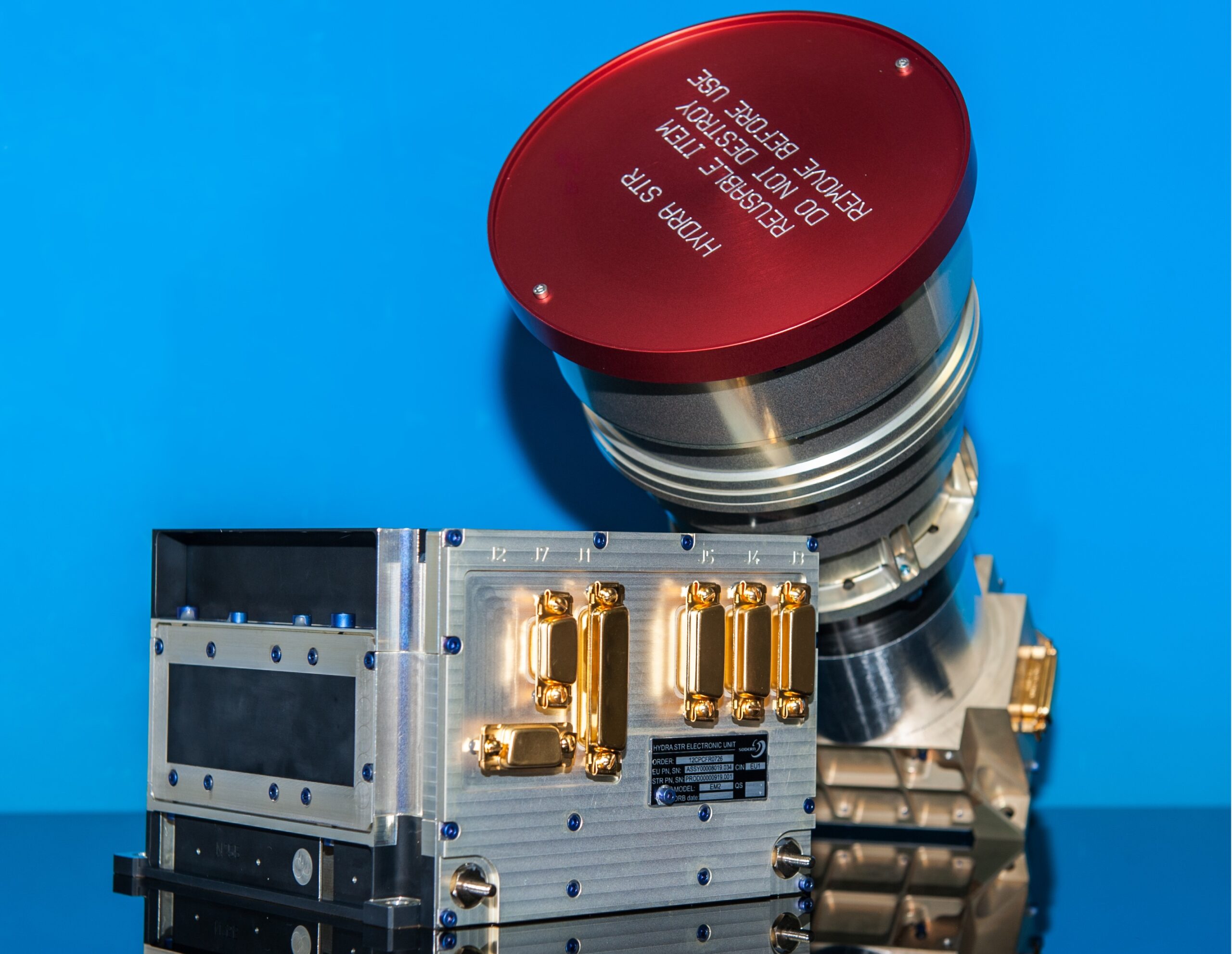
  • Star Tracker: This tool, the Sodern Hydra* Star Tracker looks at stars, like a celestial compass, to determine the satellite’s overall orientation. Three “heads” provide redundancy, with two working actively and one as a backup.
Sodern Hydra Star Tracker
Internal Layour
GOES EPP, Earth Pointing Platform

Combining these inputs, GOES-R can constantly adjust its mirrors to counteract any jitters and stay perfectly still.

Accuracy under pressure:

The accuracy of this system is crucial. The SSIRU gyroscopes must be incredibly precise, especially for short-term movements. Even tiny wobbles can blur the images. For longer-term stability, the star tracker and the software processing its data play a critical role.

Overall, this complex system of sensors and calculations allows GOES-R to maintain its stable position and deliver clear, detailed images of Earth’s weather patterns.

Key takeaways:

  • SSIRU uses gyros for fast, precise measurements of movement.
  • Star Tracker uses stars to determine overall orientation.
  • Both sensors work together to keep GOES-R stable and capture sharp images

Where am I?
How does GOES know where it is in geostationary orbit?

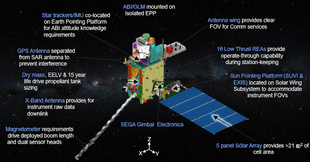
The GOES-R satellites use a special GPS receiver called the Viceroy-4 and a custom antenna to track their position in space. This is important because it allows the satellites to stay in their precise geostationary orbit, 35,786 kilometers above Earth.

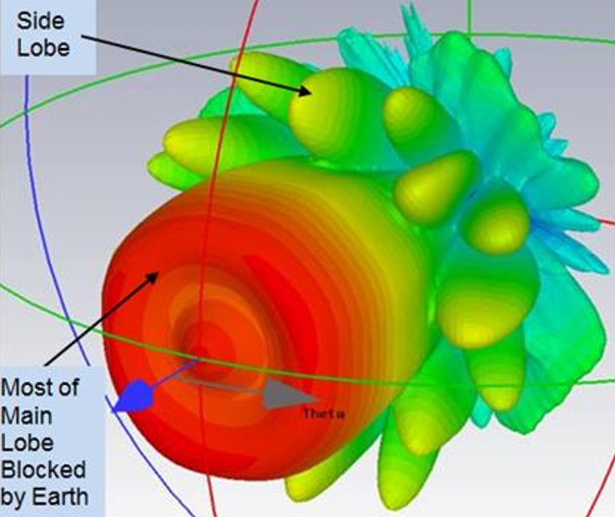
Normal GPS receivers get a strong signal directly from the satellites, but at this high altitude, the signal is weak and comes in at an angle. To pick it up, the GOES-R antenna has to point downwards, and the receiver needs to be able to listen to faint “side lobe” signals instead of the main, stronger signal.

GPS Signal as Seen by a Geostationary Satellite

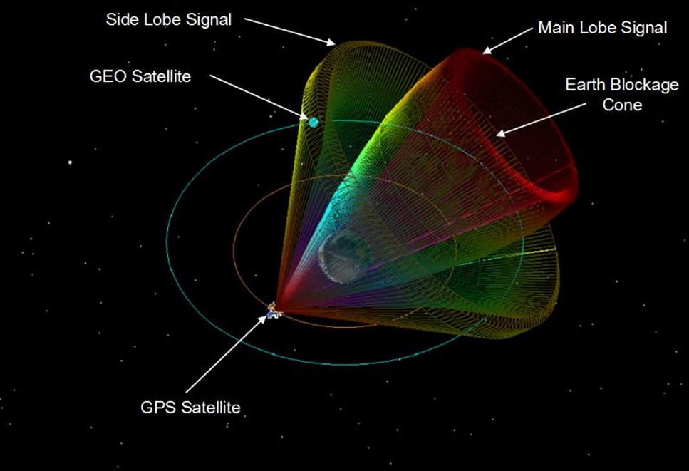
This is tricky because different GPS satellites have slightly different side lobe patterns, and the receiver needs to be able to tell a weak signal from background noise without getting overloaded by a strong one.

GPS Lobes , 3D view

Despite these challenges, the GOES-R GPS receiver can find its position within 8 minutes in most cases and then keeps track of the satellite’s location and speed very accurately. This information is used to keep the satellite pointed in the right direction and ensure it continues to provide vital weather data.

General Dynamics’ Viceroy™-4 Global Positioning System (GPS) Spaceborne Receiver

The Viceroy-4 GPS receiver provides position, velocity, and time information for Low Earth Orbit (LEO) and Geostationary Earth Orbit (GEO) applications. Performance and satellite visibility are enhanced through the use of dual antennas; each of the 18 GPS channels can be assigned to either antenna.

  • GOES-R uses a special GPS receiver and antenna for geostationary orbit.
  • They pick up “side lobe” signals because the normal signal is weak at such a high distance.
  • The receiver needs to be able to handle different signal strengths and background noise.
  • It finds the satellite’s position quickly and accurately, keeping the satellite on track.

Images provided by:
General Dynamics, NOAA, NASA- Goddard Research Center, Lockheed Martin Space Systems,and the Sodern Co.

* Hydra– a many-headed serpent or monster in Greek mythology with no affiliation to protagonist Captain America’s antagonist– HYDRA is an authoritarian-subversive paramilitary terrorist organization bent on world domination.

Tags: hardware Satellite Satellite Imagery

Post navigation

❮ Previous Post: GOES-U now GOES-19
Next Post: GOES-East Transition Plan ❯

You may also like

SUVI imagery from GOES-16
Imagery Processing
Monitoring Space Weather
July 6, 2024
Interesting stuff you should know!
Update – Goes 16 to19 Transition to Operations
March 4, 2025
News
Decommissioning NOAA-18
June 3, 2025
Satellites
Post Processing of received imagery.
December 28, 2021

Please, Help Support USRadioguy.com

If you like what I do please support me on Ko-fi, It really means a lot, every bit helps!

Hardware Humor Imagery Processing Interesting stuff you should know! Launch News Life News Product Review Satellites Science Software Space Weather Uncategorized VLOG

Alphabetical Listing of all Pages on site:

  • 36-Hour Imagery Processing script
  • 3D animation of realtime data
  • A PORTABLE WWII ERA “MORALE RADIO”
  • About Me
  • ADS-B Reception
  • Allsky Camera
  • AN/GRR-5 THE ANGRY 5
  • BD-71 Field Switch Board and EE-8B Field Telephones
  • Current GOES 16 & 18 False Color Satellite Imagery
  • Custom Color Lookup Table
  • Custom Imagery Scripts for GOES
  • Daily 3D view of Earth
  • Daily Global Composites
  • Decoding EWS-G1 or GOES-13
  • Drifting a geostationary satellite
  • DRONE FUN
  • Even the kitchen sink
  • GEO-RING COMPOSITES
  • GEO-SAT PI FRAME
  • Geo-stationary Satellite Imagery Reception
  • Global Weather Data
  • GOES 19&18 – Last 96 Hours of Imagery
  • GOES BAND IMAGERY
  • GOES GRB Reception
  • GOES receiving in Windows for SatDump
  • GOES-18 Preparing for a new satellite
  • GOES-R Series Multimedia Tour
  • GOES-U (19) Countdown to Launch
  • GOES16 A full year of received imagery
  • Ground Station Map
  • High Resolution Imagery
  • Home
  • House History
  • HRIT/EMWIN & GRB
  • HRPT Satellite Tracking and Capture
  • Hubble Space Telescope Data Processing
  • Inmarsat Decoding
  • Layering Fire and Hotspot Data on Meteor Sat Imagery
  • Layering Geo-Spatial Fire Data into Satellite Imagery
  • Mesoscale Imagery Defined
  • METEOR M2- Series
  • MODIS VIIRS Global Coverage
  • My Other Interests
  • NASA, NOAA, Military, GOVT dish, and tower stations.
  • National Hurricane Data
  • Newsletter terms & conditions
  • NOAA & Meteor APT and LRPT RECEPTION
  • Online Satellite Imagery and Information
  • Optimizing a WIFI Grid Antenna for Maximum Efficiency
  • ORBITAL DYNAMICS 101
  • Orbitron, Gpredict, and PSTRotator with new TLE format
  • PI Based Broadcastify Server
  • Pi Based Picture Frame
  • Presentations
  • Privacy Policy
  • Programming the PI for goestools operation
  • R-100/URR 1944 MORALE RADIO
  • RADIO SET SCR-284
  • Rare Captures
  • Receiving GOES 18,19 with goestools
  • Receiving GOES HRIT with SATDUMP
  • Receiving the Funcube Amateur Satellite
  • Satdump for Meteor and NOAA decoding
  • Satellite Finder
  • Satellite Frequencies
  • Satellite Ground Stations
  • Satellite Tracking
  • Security
  • SETEC Astronomy
  • Solar Power for PI
  • South America GOES 16
  • Space Weather
  • Stray Light Zone (SLZ)
  • Thanks!
  • The quest for True Color Imagery
  • Tried and Tested Hardware
  • Usradioguy Blogs
  • Usradioguy Merchandise
  • USRadioguy Newsletter
  • USRadioguy VLOGS
  • USRADIOGUY Youtube Page
  • VIBRATOR CONVERSION MODULE
  • Viterbi, R/S Errors, Packets
  • VS-3 VIBRATOR CONVERSION
  • What is RTL-SDR?
  • WWII Audio Page
  • WWII K-24 Aerial Camera
  • WWII RADIO
  • WxtoImg Fix
  • Zombie Satellites

Hardware Humor Imagery Processing Interesting stuff you should know! Launch News Life News Product Review Satellites Science Software Space Weather Uncategorized VLOG

Satellite And Weather Related Feeds

  • CIMSS Satellite Blog
  • USRadioguy.com
  • wildfires
  • NASA Earth Observatory
  • SPC Particularly Dangerous Situation (PDS) Tornado/Severe Thunderstorm Watch
  • satellites
  • Satellites News -- ScienceDaily
  • Satellite Liaison Blog
Wildfire in Ontario produces a large pyrocumulonimbus cloud
American Samoa’s Wettest Year Gets Wetter
Deadly flash flooding in Ruidoso, New Mexico
Global cloud layers on your Devices
End Of Life for NOAA 15 and 19?….not so fast…
Vitality GOES
Vitality GOES
The fire cycle
Unmasking the complicated chemistry of wildfire smoke: What's in it?
NOAA unveils powerful convergence of AI and science with revolutionary Next-Generation Fire System technology
The Salty Lake of Gas Hure
Greenland’s Bejeweled Ice Sheet
Manitoba Burning
Manitoba Burning
SPC PDS Severe Thunderstorm Watch 399
Five historically huge solar events
65 years since the world’s first weather satellite
Investing in America: NOAA's Science, Service and Stewardship in Action
Earth’s weather satellites just spent 10 years watching Venus — here’s what they found
Record-breaking 10-billion-year radio halo just rewrote the universe’s origin story
Massive thread of hot gas found linking galaxies — and it’s 10 times the mass of the Milky Way
The Need for Speed: OCTANE Cloud-Top Winds at SPC
Summer Storms, Flooding Target Mid-Atlantic
Southwest Thunderstorms – Late June 2025
  • Facebook Geo Stationary Satellites
  • Usradioguy Facebook
  • Instagram
  • Reddit
  • Github
  • Linkedin

Copyright © 2025 USRadioguy.com - All Rights Reserved. All material protected by Fair Use Section 107 of the Copyright Act. This site is Verified and Secured with 256 bit SSL encryption