Skip to content
USRADIOGUY

USRadioguy.com

Welcome to USRadioguy.com – Unlocking the Potential of Software Defined Radio

  • Home
    • Home of USRadioguy
    • USRadioguy Newsletter
    • Tried and Tested Hardware
    • What is RTL-SDR?
    • Global Weather Data
  • Satellite Reception
    • Geo Stationary Satellites
      • Geo-stationary Satellite Imagery Reception
      • GOESTOOLS on the PI
      • Update Goestools for GOES 18,19
      • Receiving GOES with SatDump CLI Mode
      • GOES receiving in Windows for SatDump GUI
      • Decoding EWS-G1/EWS-G2
      • GOES GRB Reception WIP
      • Optimizing a WIFI Grid Antenna for Maximum Efficiency
    • APT Satellites
      • APT RECEPTION
      • Satdump for Meteor and NOAA decoding
      • METEOR M2- Series
      • WxtoImg Fix
      • Converting to new TLE format
      • Layering Fire and Hotspot Data on Meteor Sat Imagery
      • HRPT Satellite Tracking and Capture
    • Receiving Other Satellites
      • Inmarsat Decoding
      • Receiving the Funcube Amateur Satellite
    • User Maps and Dish Pointers
      • Satellite Dish Pointer
      • User Global Ground Station Maps
      • Usermap rendered with Cesium
      • Global Map of Govt Dish Stations
    • Satellite Details & Information
      • ORBITAL DYNAMICS 101
      • HRIT/EMWIN & GRB Defined
      • Mesoscale Imagery Defined
      • Viterbi, R/S Errors, Packets
      • GOES BAND IMAGERY
      • Stray Light Zone (SLZ)
      • Drifting a geostationary satellite
      • GOES-R Series Multimedia Tour
      • Online Satellite Imagery and Information
      • Satellite Frequencies
      • Solar and Space Weather
  • Satellite Imagery
    • IMAGERY- Current GOES East & West HRIT Satellite Imagery
    • IMAGERY- GOES 16&18 – Past 96 Hours of Imagery
    • High Resolution Imagery
    • Daily 3D view of Earth
    • NOAA APT Satellite imagery
    • PlanetMaker
    • GOES16 A full year of received imagery
  • Imagery Processing
    • Custom Color Lookup Table & Gradients
    • GOES-R Custom Imagery Scripts
    • Global geo-ring composites
    • MODIS VIIRS Global Coverage
    • 3D Satellite Tracking
    • The quest for True Color Imagery
    • 3D animation of realtime data
    • Layering Geo-Spatial Fire Data into Satellite Imagery
    • Orbital dynamics and the Moon
    • National Hurricane Data
  • News, VLOGS & BLOGS
    • News & USRadioguy Blogs
    • USRadioguy VLOGS
  • Project Lab
    • Orbital Information and Visualizations
      • Enhanced Planet Earth
      • Satellites in Orbit
      • Solar System
      • Objects in Orbit
    • Current Station Weather
      • Current Groundstation Weather
      • Global Weather Data
      • Space Weather
    • WWII RADIO
      • WWII K-24 Aerial Camera
      • WWII RADIO
      • RADIO SET SCR-284
      • VS-3 VIBRATOR CONVERSION
      • VIBRATOR CONVERSION MODULE
      • BD-71 Field Switch Board and EE-8B Field Telephones
      • R-100/URR 1944 MORALE RADIO
      • A PORTABLE WWII ERA “MORALE RADIO”
      • AN/GRR-5 THE ANGRY 5
      • WWII Audio Page
    • Raspberry Pi Projects
      • ADS-B Reception
      • Allsky Camera
      • Pi Based Picture Frame
      • PI Based Broadcastify Server
      • Solar Power for PI
    • Hubble Space Telescope Data Processing
    • Zombie Satellites
    • DRONES
  • About Me
    • About Usradioguy
      • SETEC Astronomy
    • Tried and Tested Hardware
    • Rare Captures
    • My Other Interests
    • Presentations
    • Merchandise
    • Privacy Policy
  • Home
  • Science
  • Hunga Tonga Eruption

Hunga Tonga Eruption

Posted on January 20, 2024November 4, 2024 By Carl
Imagery Processing, Interesting stuff you should know!, News, Satellites, Science

Loading

Hunga Tonga Hunga Haʻapai Eruption

On 20 December 2023 Hunga Tonga Hunga Haʻapai erupted after being relatively inactive since 2014, causing a large plume that was visible from Nukuʻalofa. The Volcanic Ash Advisory Centre Wellington NZ issued an advisory to airlines. Explosions could be heard up to 170 kilometers (110 mi) away. The initial eruption continued until 2 am on 21 December. Activity continued, and on 25 December, satellite imagery showed that the island had increased in size.

Volcanic activity died down on 5 January before restarting on 13 January after the volcano sent an ash cloud 17 km (55,000 ft) into the atmosphere. The government subsequently issued a tsunami warning.

Hunga Tonga Hunga Haʻapai Eruption on 13 January 2021

Location of Hunga Tonga

On 15 January, the volcano violently erupted again, about seven times more powerfully than the eruption on 20 December 2021. There were numerous reports of loud booms across Tonga and other countries, such as Fiji and as far away as New Zealand and Australia. A boom was heard in Alaska seven hours after the eruption. 

January 15 Eruption as received via GOES 17.
GRB Imagery of the 15, January Eruption
GOES 17 Mesoscale Imagery from band 13 enhanced.

Near the eruption, the explosion damaged property, including shattered windows. A tsunami warning was issued just after 5:30 p.m. by the Tonga Meteorological Services and the tsunami flooded coastal areas in Tonga. A 3.9 ft (1.2 m) tsunami was observed in Nukuʻalofa, Tonga, and a 2.0 ft (0.61 m) one in American Samoa.

Two people were killed in Peru and two fishermen were injured in San Gregorio, California and the body of a British woman was found in Tonga after she went missing when the tsunami struck the South Pacific island. 


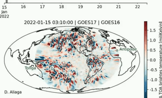
Post analysis of the Hunga Tonga Hunga Haʻapai eruption has clearly shown there has been a global impact.

Using GOES 17 IR imagery and applying some filters and negative inversion of the images on GOES 17 Imagery to enhance the shock wave from Hunga Tonga. Images every 30 minutes is why it is not ‘smooth’.

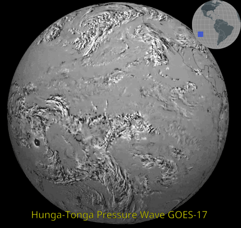
Clearly, you can see the shock wave as it circumnavigated the entire globe. In the image below, created from pressure sensor data across the United States, you can see the wave as it crossed the continent at the speed of sound. 0400 UTC to 1030UTC on the 15th. Wave starts supersonic but then reduces as it travels through the atmosphere. My calcs on the average speed is about 700 MPH

Pressure sensors recording the shock wave. You can see the propagation of the wave across the country. Credit IEM

Like waves you see in the water, these waves create vertical displacements of air causing surface air pressure fluctuations. The video above provides an animation of minute interval pressure data observed from NWS/FAA ASOS stations. The data is presented in the form of “sparklines”. Each line represents the map location of an observation time series lasting 15 minutes. The north/south variation in the line represents a change in pressure with the color being the magnitude over the 15 minutes.

The second pressure wave from Hunga Tonga Eruption as it travels East to West (the first traveled West to East) . This one traversed the globe in the other direction and so arriving on the east coast first. This lapse is from early Sunday morning and guess what, there are still more lapses to be shown as the waves continue to propagate around the globe. It is unclear when these waves will disappear, but given the size of the eruption and some limited literature on previous documented events, it is likely soon.

Credit IEM

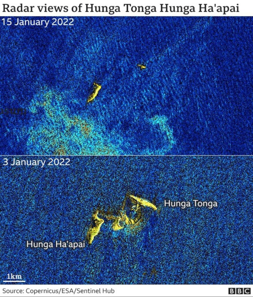
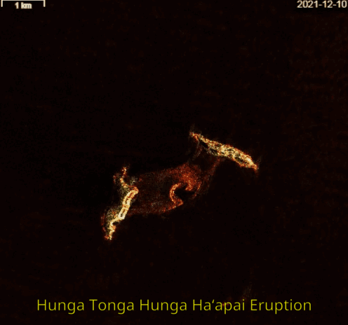
On 16 January satellite radar surveys before and after the eruption show that most of the island has been destroyed. Only small parts of Hunga Tonga and Hunga Haʻapai remained.

EU’s Sentinel-1A satellite This spacecraft has a radar platform and can see through obscuring clouds and ash to the surface below.
It showed clearly that much of the crater rim that stood above the ocean waters had been destroyed – a testament to the ferocity of the blast.

January 23rd 2022 -It is amazing that after 7 days the Hunga Tonga shock wave continues to circle the planet (10 times!) and can still be detected in the infrared by geostationary satellites such as GOES 16 and GOES17. Credit -University of Helsinki

Post navigation

❮ Previous Post: GOES-15 is now EWS-G2
Next Post: Life after GOES, The GEO XO mission ❯

You may also like

Satellites
GOES-T Launch COUNTDOWN
February 26, 2022
Satellites
Goestools for Windows
July 14, 2023
Satellites
Vitality GOES
January 27, 2023
SUVI imagery from GOES-16
Imagery Processing
Monitoring Space Weather
July 6, 2024

Please, Help Support USRadioguy.com

If you like what I do please support me on Ko-fi, It really means a lot, every bit helps!

Hardware Humor Imagery Processing Interesting stuff you should know! Launch News Life News Product Review Satellites Science Software Space Weather Uncategorized VLOG

Alphabetical Listing of all Pages on site:

  • 36-Hour Imagery Processing script
  • 3D animation of realtime data
  • A PORTABLE WWII ERA “MORALE RADIO”
  • About Me
  • ADS-B Reception
  • Allsky Camera
  • AN/GRR-5 THE ANGRY 5
  • BD-71 Field Switch Board and EE-8B Field Telephones
  • Current GOES 16 & 18 False Color Satellite Imagery
  • Custom Color Lookup Table
  • Custom Imagery Scripts for GOES
  • Daily 3D view of Earth
  • Daily Global Composites
  • Decoding EWS-G1 or GOES-13
  • Drifting a geostationary satellite
  • DRONE FUN
  • Even the kitchen sink
  • GEO-RING COMPOSITES
  • GEO-SAT PI FRAME
  • Geo-stationary Satellite Imagery Reception
  • Global Weather Data
  • GOES 19&18 – Last 96 Hours of Imagery
  • GOES BAND IMAGERY
  • GOES GRB Reception
  • GOES receiving in Windows for SatDump
  • GOES-18 Preparing for a new satellite
  • GOES-R Series Multimedia Tour
  • GOES-U (19) Countdown to Launch
  • GOES16 A full year of received imagery
  • Ground Station Map
  • High Resolution Imagery
  • Home
  • House History
  • HRIT/EMWIN & GRB
  • HRPT Satellite Tracking and Capture
  • Hubble Space Telescope Data Processing
  • Inmarsat Decoding
  • Layering Fire and Hotspot Data on Meteor Sat Imagery
  • Layering Geo-Spatial Fire Data into Satellite Imagery
  • Mesoscale Imagery Defined
  • METEOR M2- Series
  • MODIS VIIRS Global Coverage
  • My Other Interests
  • NASA, NOAA, Military, GOVT dish, and tower stations.
  • National Hurricane Data
  • Newsletter terms & conditions
  • NOAA & Meteor APT and LRPT RECEPTION
  • Online Satellite Imagery and Information
  • Optimizing a WIFI Grid Antenna for Maximum Efficiency
  • ORBITAL DYNAMICS 101
  • Orbitron, Gpredict, and PSTRotator with new TLE format
  • PI Based Broadcastify Server
  • Pi Based Picture Frame
  • Presentations
  • Privacy Policy
  • Programming the PI for goestools operation
  • R-100/URR 1944 MORALE RADIO
  • RADIO SET SCR-284
  • Rare Captures
  • Receiving GOES 18,19 with goestools
  • Receiving GOES HRIT with SATDUMP
  • Receiving the Funcube Amateur Satellite
  • Satdump for Meteor and NOAA decoding
  • Satellite Finder
  • Satellite Frequencies
  • Satellite Ground Stations
  • Satellite Tracking
  • Security
  • SETEC Astronomy
  • Solar Power for PI
  • South America GOES 16
  • Space Weather
  • Stray Light Zone (SLZ)
  • Thanks!
  • The quest for True Color Imagery
  • Tried and Tested Hardware
  • Usradioguy Blogs
  • Usradioguy Merchandise
  • USRadioguy Newsletter
  • USRadioguy VLOGS
  • USRADIOGUY Youtube Page
  • VIBRATOR CONVERSION MODULE
  • Viterbi, R/S Errors, Packets
  • VS-3 VIBRATOR CONVERSION
  • What is RTL-SDR?
  • WWII Audio Page
  • WWII K-24 Aerial Camera
  • WWII RADIO
  • WxtoImg Fix
  • Zombie Satellites

Hardware Humor Imagery Processing Interesting stuff you should know! Launch News Life News Product Review Satellites Science Software Space Weather Uncategorized VLOG

Satellite And Weather Related Feeds

  • CIMSS Satellite Blog
  • USRadioguy.com
  • wildfires
  • NASA Earth Observatory
  • SPC Particularly Dangerous Situation (PDS) Tornado/Severe Thunderstorm Watch
  • satellites
  • Satellites News -- ScienceDaily
  • Satellite Liaison Blog
Using Polar2grid and Direct Broadcast files to create imagery
Cirrus over the western Great Lakes
Wildfire in Saskatchewan produces a pyrocumulonimbus cloud
End Of Life for NOAA 15,18,19?….not so fast…
GOES-19 now GOES-EAST
GOES 19 Operational Schedule
The fire cycle
March was nation's 6th warmest on record
Podcast: Could the LA Wildfires harm California's marine life?
A Smoky Start to Saskatchewan’s Fire Season
Mapping the Tiny Plankton That Feed Giant Right Whales
Lights of Southeast Asia
SPC PDS Tornado Watch 98
Five historically huge solar events
65 years since the world’s first weather satellite
Investing in America: NOAA's Science, Service and Stewardship in Action
Satellite measures CO2 and NO2 simultaneously from power plant emissions for the first time
Existing international law can help secure peace and security in outer space
Small, faint and 'unexpected in a lot of different ways': Astronomers make galactic discovery
Another Week, Another Deep South Soaker
4 May 2025 Dust and Accumulating Hail
Southern Plains Deluge
  • Facebook Geo Stationary Satellites
  • Usradioguy Facebook
  • Instagram
  • Reddit
  • Github
  • Linkedin

Copyright © 2025 USRadioguy.com - All Rights Reserved. All material protected by Fair Use Section 107 of the Copyright Act. This site is Verified and Secured with 256 bit SSL encryption