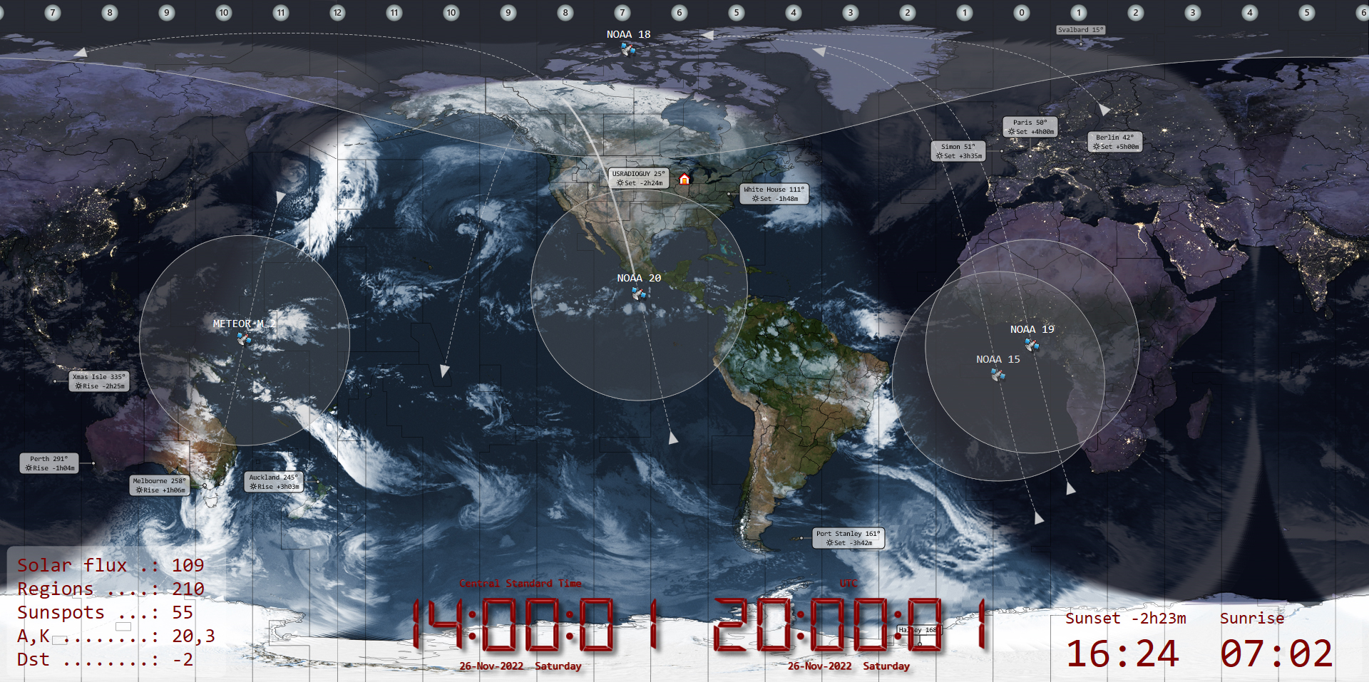
Skip to content
USRADIOGUY

USRadioguy.com

Welcome to USRadioguy.com – Unlocking the Potential of Software Defined Radio

  • Home
    • Home of USRadioguy
    • USRadioguy Newsletter
    • Tried and Tested Hardware
    • What is RTL-SDR?
    • Global Weather Data
  • Satellite Reception
    • Geo Stationary Satellites
      • Geo-stationary Satellite Imagery Reception
      • GOESTOOLS on the PI
      • Update Goestools for GOES 18,19
      • Receiving GOES with SatDump CLI Mode
      • GOES receiving in Windows for SatDump GUI
      • Decoding EWS-G1/EWS-G2
      • GOES GRB Reception WIP
      • Optimizing a WIFI Grid Antenna for Maximum Efficiency
    • APT Satellites
      • APT RECEPTION
      • NOAA APT Satellite imagery
      • Satdump for Meteor and NOAA decoding
      • METEOR M2- Series
      • WxtoImg Fix
      • Converting to new TLE format
      • Layering Fire and Hotspot Data on Meteor Sat Imagery
      • HRPT Satellite Tracking and Capture
    • Receiving Other Satellites
      • Inmarsat Decoding
      • Receiving the Funcube Amateur Satellite
    • User Maps and Dish Pointers
      • Satellite Dish Pointer
      • User Global Ground Station Maps
      • Usermap rendered with Cesium
      • Global Map of Govt Dish Stations
    • Satellite Details & Information
      • ORBITAL DYNAMICS 101
      • HRIT/EMWIN & GRB Defined
      • Mesoscale Imagery Defined
      • Viterbi, R/S Errors, Packets
      • GOES BAND IMAGERY
      • Stray Light Zone (SLZ)
      • Drifting a geostationary satellite
      • GOES-R Series Multimedia Tour
      • Online Satellite Imagery and Information
      • Satellite Frequencies
      • Solar and Space Weather
  • Satellite Imagery
    • IMAGERY- Current GOES East & West HRIT Satellite Imagery
    • IMAGERY- GOES 16&18 – Past 96 Hours of Imagery
    • Daily Global Composites
    • High Resolution Imagery
    • Daily 3D view of Earth
    • PlanetMaker
    • GOES16 A full year of received imagery
  • Imagery Processing
    • Custom Color Lookup Table & Gradients
    • GOES-R Custom Imagery Scripts
    • Global geo-ring composites
    • MODIS VIIRS Global Coverage
    • 3D Satellite Tracking
    • The quest for True Color Imagery
    • 3D animation of realtime data
    • Layering Geo-Spatial Fire Data into Satellite Imagery
    • Orbital dynamics and the Moon
    • National Hurricane Data
  • News, VLOGS & BLOGS
    • News & USRadioguy Blogs
    • USRadioguy VLOGS
  • Project Lab
    • Orbital Information and Visualizations
      • Enhanced Planet Earth
      • Satellites in Orbit
      • Solar System
      • Objects in Orbit
    • Current Station Weather
      • Current Groundstation Weather
      • Global Weather Data
      • Space Weather
    • WWII RADIO
      • WWII K-24 Aerial Camera
      • WWII RADIO
      • RADIO SET SCR-284
      • VS-3 VIBRATOR CONVERSION
      • VIBRATOR CONVERSION MODULE
      • BD-71 Field Switch Board and EE-8B Field Telephones
      • R-100/URR 1944 MORALE RADIO
      • A PORTABLE WWII ERA “MORALE RADIO”
      • AN/GRR-5 THE ANGRY 5
    • Raspberry Pi Projects
      • Allsky Camera
      • Pi Based Picture Frame
      • PI Based Broadcastify Server
      • Solar Power for PI
      • ADS-B Reception
    • Hubble Space Telescope Data Processing
    • Zombie Satellites
    • DRONES
  • About Me
    • About Usradioguy
    • Tried and Tested Hardware
    • Rare Captures
    • My Other Interests
    • Presentations
    • Merchandise
    • Privacy Policy
  • Home
  • Satellites
  • Simon’s World Map

Simon’s World Map

Posted on March 24, 2024June 18, 2024 By Carl
Satellites, Software

Loading

UPDATE: 03-24-2024 Simon has updated the map (Current: Version 1.4.0)

Version 1.4.0 shown using my global geo satellite imagery, and selected features of the World Map. Notice the added scroll bar option at the bottom!
  • Improved Appearance settings:
    • Clock: Optional display of seconds (HH:MM or HH:MM:ss)
    • Full Screen: Mouse over map now displays (X)
    • Help files now include images
    • Optional Logos for non-Ham users (Ribbon Bar, View, Logo)
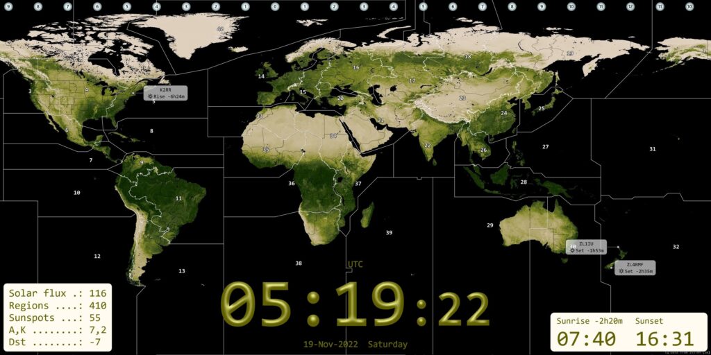
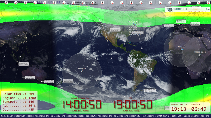
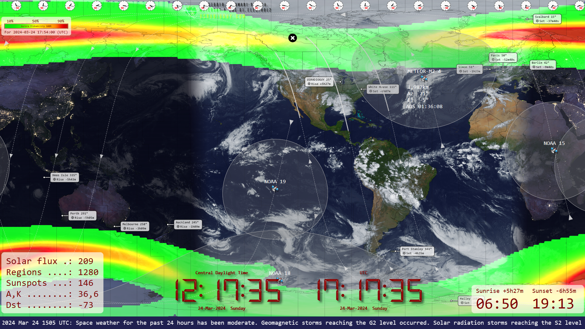
  • Superb new maps from Maps In Minutes
  • WWV alerts scrolling added (Ribbon bar, Space Weather, Data, Geophysical Alert Message) – future multi-threaded update for smoother flow. (LOVE THIS FEATURE!!)
  • Improved Zoom:
    • Smoother transition from 100% to zoomed view
    • Fixed sun, moon etc. centre tracking
    • Keyboard zoom with – and + keys
    • Zoomed view: Ribbon bar drops down when mouse reaches top of display
    • Adjusted zoom scroll granularity (mouse wheel, shift)

ntroducing the ultimate world map for satellite enthusiasts: a powerful and user-friendly tool that goes way beyond just showing you the Earth!

Have you ever wished your world map could do more?

This software is a game-changer. It’s packed with features specifically designed for satellite enthusiasts, like:

  • DDE tracking: Stay on top of your favorite satellites with effortless precision.
  • Rotator support: Control your rotator antenna directly through the software for seamless operation.
  • Add stations and customize the map: Make it your own and tailor it to your exact needs.
  • And so much more!

This is more than just a map – it’s a complete satellite enthusiast’s toolkit.

Plus, it’s:

  • Lightweight: Runs smoothly on any Windows system without bogging down your computer.
  • Easy to use: No need to be a tech wiz to get started.

Don’t settle for ordinary world maps. Take your satellite exploration to the next level!

Windows 7, 8, 10, and 11 compatible. x86 architecture required.

Since I already generate them, I am using a daily global received geo sat image as the background map. The software has a list of maps, and a custom section for you to add your own, which I did here.

The world map can be downloaded from Simon’s site here https://www.g4eli.com/world-map

Tags: Satellite Imagery Satellite Tracking software World Map

Post navigation

❮ Previous Post: The Seasons
Next Post: GOES-U, the 4th and Last of the GOES-R Series ❯

You may also like

Hardware
NOAA Requests proposals to limit 5G (6G) interference.
April 15, 2023
Satellites
Invited to present at SSEC CMISS
August 28, 2020
Satellites
Post Processing of received imagery.
December 28, 2021
Launch News
GOES-U to Launch in June
June 8, 2024

Please, Help Support USRadioguy.com

If you like what I do please support me on Ko-fi, It really means a lot, every bit helps!

Hardware Humor Imagery Processing Interesting stuff you should know! Launch News Life News Product Review Satellites Science Software Space Weather Uncategorized VLOG

Alphabetical Listing of all Pages on site:

  • 36-Hour Imagery Processing script
  • 3D animation of realtime data
  • A PORTABLE WWII ERA “MORALE RADIO”
  • About Me
  • ADS-B Reception
  • Allsky Camera
  • AN/GRR-5 THE ANGRY 5
  • BD-71 Field Switch Board and EE-8B Field Telephones
  • Current GOES 16 & 18 False Color Satellite Imagery
  • Custom Color Lookup Table
  • Custom Imagery Scripts for GOES
  • Daily 3D view of Earth
  • Daily Global Composites
  • Decoding EWS-G1 or GOES-13
  • Drifting a geostationary satellite
  • DRONE FUN
  • Even the kitchen sink
  • GEO-RING COMPOSITES
  • GEO-SAT PI FRAME
  • Geo-stationary Satellite Imagery Reception
  • Global Weather Data
  • GOES 16&18 – Last 96 Hours of Imagery
  • GOES BAND IMAGERY
  • GOES GRB Reception
  • GOES receiving in Windows for SatDump
  • GOES-18 Preparing for a new satellite
  • GOES-R Series Multimedia Tour
  • GOES-U (19) Countdown to Launch
  • GOES16 A full year of received imagery
  • Ground Station Map
  • High Resolution Imagery
  • Home
  • House History
  • HRIT/EMWIN & GRB
  • HRPT Satellite Tracking and Capture
  • Hubble Space Telescope Data Processing
  • Inmarsat Decoding
  • Layering Fire and Hotspot Data on Meteor Sat Imagery
  • Layering Geo-Spatial Fire Data into Satellite Imagery
  • Mesoscale Imagery Defined
  • METEOR M2- Series
  • MODIS VIIRS Global Coverage
  • My Other Interests
  • NASA, NOAA, Military, GOVT dish, and tower stations.
  • National Hurricane Data
  • Newsletter terms & conditions
  • NOAA & Meteor APT and LRPT RECEPTION
  • Online Satellite Imagery and Information
  • Optimizing a WIFI Grid Antenna for Maximum Efficiency
  • ORBITAL DYNAMICS 101
  • Orbitron, Gpredict, and PSTRotator with new TLE format
  • PI Based Broadcastify Server
  • Pi Based Picture Frame
  • Presentations
  • Privacy Policy
  • Programming the PI for goestools operation
  • R-100/URR 1944 MORALE RADIO
  • RADIO SET SCR-284
  • Rare Captures
  • Receiving GOES 18,19 with goestools
  • Receiving GOES HRIT with SATDUMP
  • Receiving the Funcube Amateur Satellite
  • Satdump for Meteor and NOAA decoding
  • Satellite Finder
  • Satellite Frequencies
  • Satellite Ground Stations
  • Satellite Tracking
  • Security
  • Solar Power for PI
  • South America GOES 16
  • Space Weather
  • Stray Light Zone (SLZ)
  • Thanks!
  • The quest for True Color Imagery
  • Tried and Tested Hardware
  • Usradioguy Blogs
  • Usradioguy Merchandise
  • USRadioguy Newsletter
  • USRadioguy VLOGS
  • USRADIOGUY Youtube Page
  • VIBRATOR CONVERSION MODULE
  • Viterbi, R/S Errors, Packets
  • VS-3 VIBRATOR CONVERSION
  • What is RTL-SDR?
  • WWII K-24 Aerial Camera
  • WWII RADIO
  • WxtoImg Fix
  • Zombie Satellites

Hardware Humor Imagery Processing Interesting stuff you should know! Launch News Life News Product Review Satellites Science Software Space Weather Uncategorized VLOG

Satellite And Weather Related Feeds

  • CIMSS Satellite Blog
  • USRadioguy.com
  • wildfires
  • NASA Earth Observatory
  • SPC Particularly Dangerous Situation (PDS) Tornado/Severe Thunderstorm Watch
  • satellites
  • Satellites News -- ScienceDaily
  • Satellite Liaison Blog
Assessing Rain chances on American Samoa
Satellite signatures of a bolide over the Canada/US border
Man-Yi moves through the Marianas Islands
Open Weather APT
Open Weather APT
NOAA’s CCOR-1: A New Eye on the Sun
SDR on Windows ARM64 Architecture
The fire cycle
It's not just hot air: Improved air quality model aids forecasters in the field
NOAA scientists testing next generation of wildfire detection, warning tools
Typhoons Line Up in the Western Pacific
Blankets of White in the West
Sizing Up a Greenland Tsunami
SPC PDS Tornado Watch 320
Next-gen instrument will be game changer for satellite ocean observations
NOAA’s GOES-U heads to orbit for historic mission
Cool imagery from the GOES satellite series, a retrospective
Laser measurements to track space debris and observe water masses
Study coordinates satellite swarm for 3D imaging inside clouds
How special is the Milky Way Galaxy?
Rockies Greeted with First Major Snow of the Season
California Mountain Fire Nov 2024
North Pacific Rages On
  • Facebook Geo Stationary Satellites
  • Usradioguy Facebook
  • Instagram
  • Reddit
  • Github
  • Linkedin

Copyright © 2024 USRadioguy.com - All Rights Reserved. All material protected by Fair Use Section 107 of the Copyright Act. This site is Verified and Secured with 256 bit SSL encryption