Skip to content
USRADIOGUY

USRadioguy.com

Welcome to USRadioguy.com – Unlocking the Potential of Software Defined Radio

  • Home
    • Home of USRadioguy
    • USRadioguy Newsletter
    • Tried and Tested Hardware
    • What is RTL-SDR?
    • Global Weather Data
  • Satellite Reception
    • Geo Stationary Satellites
      • Geo-stationary Satellite Imagery Reception
      • GOESTOOLS on the PI
      • Update Goestools for GOES 18,19
      • Receiving GOES with SatDump CLI Mode
      • GOES receiving in Windows for SatDump GUI
      • Decoding EWS-G1/EWS-G2
      • GOES GRB Reception WIP
      • Optimizing a WIFI Grid Antenna for Maximum Efficiency
    • APT Satellites
      • APT RECEPTION
      • NOAA APT Satellite imagery
      • Satdump for Meteor and NOAA decoding
      • METEOR M2- Series
      • WxtoImg Fix
      • Converting to new TLE format
      • Layering Fire and Hotspot Data on Meteor Sat Imagery
      • HRPT Satellite Tracking and Capture
    • Receiving Other Satellites
      • Inmarsat Decoding
      • Receiving the Funcube Amateur Satellite
    • User Maps and Dish Pointers
      • Satellite Dish Pointer
      • User Global Ground Station Maps
      • Usermap rendered with Cesium
      • Global Map of Govt Dish Stations
    • Satellite Details & Information
      • ORBITAL DYNAMICS 101
      • HRIT/EMWIN & GRB Defined
      • Mesoscale Imagery Defined
      • Viterbi, R/S Errors, Packets
      • GOES BAND IMAGERY
      • Stray Light Zone (SLZ)
      • Drifting a geostationary satellite
      • GOES-R Series Multimedia Tour
      • Online Satellite Imagery and Information
      • Satellite Frequencies
      • Solar and Space Weather
  • Satellite Imagery
    • IMAGERY- Current GOES East & West HRIT Satellite Imagery
    • IMAGERY- GOES 16&18 – Past 96 Hours of Imagery
    • Daily Global Composites
    • High Resolution Imagery
    • Daily 3D view of Earth
    • PlanetMaker
    • GOES16 A full year of received imagery
  • Imagery Processing
    • Custom Color Lookup Table & Gradients
    • GOES-R Custom Imagery Scripts
    • Global geo-ring composites
    • MODIS VIIRS Global Coverage
    • 3D Satellite Tracking
    • The quest for True Color Imagery
    • 3D animation of realtime data
    • Layering Geo-Spatial Fire Data into Satellite Imagery
    • Orbital dynamics and the Moon
    • National Hurricane Data
  • News, VLOGS & BLOGS
    • News & USRadioguy Blogs
    • USRadioguy VLOGS
  • Project Lab
    • Orbital Information and Visualizations
      • Enhanced Planet Earth
      • Satellites in Orbit
      • Solar System
      • Objects in Orbit
    • Current Station Weather
      • Current Groundstation Weather
      • Global Weather Data
      • Space Weather
    • WWII RADIO
      • WWII K-24 Aerial Camera
      • WWII RADIO
      • RADIO SET SCR-284
      • VS-3 VIBRATOR CONVERSION
      • VIBRATOR CONVERSION MODULE
      • BD-71 Field Switch Board and EE-8B Field Telephones
      • R-100/URR 1944 MORALE RADIO
      • A PORTABLE WWII ERA “MORALE RADIO”
      • AN/GRR-5 THE ANGRY 5
    • Raspberry Pi Projects
      • Allsky Camera
      • Pi Based Picture Frame
      • PI Based Broadcastify Server
      • Solar Power for PI
      • ADS-B Reception
    • Hubble Space Telescope Data Processing
    • Zombie Satellites
    • DRONES
  • About Me
    • About Usradioguy
    • Tried and Tested Hardware
    • Rare Captures
    • My Other Interests
    • Presentations
    • Merchandise
    • Privacy Policy
  • Home
  • Science
  • GOES T Launch Dynamics

GOES T Launch Dynamics

Posted on February 14, 2022February 14, 2022 By Carl
Satellites, Science

Loading

MISSION OVERVIEW

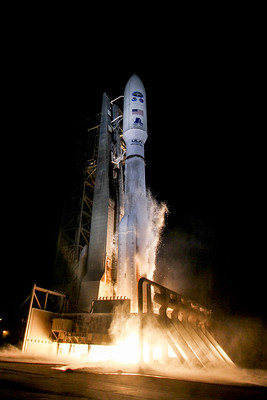
A United Launch Alliance (ULA) Atlas V 541 rocket will deliver the National Oceanic and Atmospheric Administration (NOAA) GOES-T spacecraft to an optimized geosynchronous transfer orbit. The optimized orbit places GOES-T closer to its final destination thereby conserving the satellite’s fuel supply for longer mission life. The mission is conducted in collaboration with NASA. Liftoff will occur from Space Launch Complex-41 at Cape Canaveral Space Force Station, Fla.

LAUNCH VEHICLE

Payload Fairing (PLF)

The spacecraft is encapsulated in a 17-ft (5-m) diameter short payload fairing. The 5-m PLF is a sandwich composite structure made with a vented aluminum-honeycomb core and graphite-epoxy face sheets. The bisector (two-piece shell) PLF encapsulates both the Centaur and the satellite. The vehicle’s height with the 5-meter short PLF is approximately 196 ft (59.7 m).

GOEST_ExpandedViewvehicle_ExternalWebsite
Rocket Components

Centaur

The Centaur second stage is 10 ft (3 m) in diameter and 41.5 ft (12.6 m) in length. Its propellant tanks are pressure-stabilized and constructed of corrosion-resistant stainless steel. Centaur is a cryogenic vehicle, fueled with liquid hydrogen and liquid oxygen, powered by an RL10C-1 engine producing 22,900 lbs (101.8 kilo-Newtons) of thrust. The cryogenic tanks are insulated with a combination of helium-purged blankets, radiation shields and spray-on foam insulation (SOFI). The Centaur forward adapter (CFA) provides structural mountings for the fault-tolerant avionics system and structural and electrical interfaces with the spacecraft.

Booster

The booster is 12.5 ft (3.8 m) in diameter and 106.5 ft (32.5 m) in length. The booster’s tanks are structurally rigid and constructed of isogrid aluminum barrels, spun-formed aluminum domes, and intertank skirts. Booster propulsion is provided by the RD-180 engine system (a single engine with two thrust chambers). The RD-180 burns RP-1 (Rocket Propellant-1 or highly purified kerosene) and liquid oxygen and delivers 860,200 lbs (3.83 mega-Newtons) of thrust at sea level. Four solid rocket boosters (SRBs) generate the additional power required at liftoff, with each providing 371,550 lbs (1.6 mega-Newtons) of thrust. The Centaur avionics system, provides guidance, flight control, and vehicle sequencing functions during the booster and Centaur phases of flight.

FLIGHT PROFILE

Graphics by United Launch Alliance

Post navigation

❮ Previous Post: GOES-T Encapsulated inside payload fairings
Next Post: GOES-T Mated to Atlas-V ❯

You may also like

Satellites
GOES-18 First Light Imagery
May 11, 2022
Satellites
GOES-U, the 4th and Last of the GOES-R Series
March 26, 2024
USRadioguy VLOG
Life
USRadioguy VLOG
February 19, 2023
Satellites
GOES-U on track for April Launch
March 3, 2022

Please, Help Support USRadioguy.com

If you like what I do please support me on Ko-fi, It really means a lot, every bit helps!

Hardware Humor Imagery Processing Interesting stuff you should know! Launch News Life News Product Review Satellites Science Software Space Weather Uncategorized VLOG

Alphabetical Listing of all Pages on site:

  • 36-Hour Imagery Processing script
  • 3D animation of realtime data
  • A PORTABLE WWII ERA “MORALE RADIO”
  • About Me
  • ADS-B Reception
  • Allsky Camera
  • AN/GRR-5 THE ANGRY 5
  • BD-71 Field Switch Board and EE-8B Field Telephones
  • Current GOES 16 & 18 False Color Satellite Imagery
  • Custom Color Lookup Table
  • Custom Imagery Scripts for GOES
  • Daily 3D view of Earth
  • Daily Global Composites
  • Decoding EWS-G1 or GOES-13
  • Drifting a geostationary satellite
  • DRONE FUN
  • Even the kitchen sink
  • GEO-RING COMPOSITES
  • GEO-SAT PI FRAME
  • Geo-stationary Satellite Imagery Reception
  • Global Weather Data
  • GOES 16&18 – Last 96 Hours of Imagery
  • GOES BAND IMAGERY
  • GOES GRB Reception
  • GOES receiving in Windows for SatDump
  • GOES-18 Preparing for a new satellite
  • GOES-R Series Multimedia Tour
  • GOES-U (19) Countdown to Launch
  • GOES16 A full year of received imagery
  • Ground Station Map
  • High Resolution Imagery
  • Home
  • House History
  • HRIT/EMWIN & GRB
  • HRPT Satellite Tracking and Capture
  • Hubble Space Telescope Data Processing
  • Inmarsat Decoding
  • Layering Fire and Hotspot Data on Meteor Sat Imagery
  • Layering Geo-Spatial Fire Data into Satellite Imagery
  • Mesoscale Imagery Defined
  • METEOR M2- Series
  • MODIS VIIRS Global Coverage
  • My Other Interests
  • NASA, NOAA, Military, GOVT dish, and tower stations.
  • National Hurricane Data
  • Newsletter terms & conditions
  • NOAA & Meteor APT and LRPT RECEPTION
  • Online Satellite Imagery and Information
  • Optimizing a WIFI Grid Antenna for Maximum Efficiency
  • ORBITAL DYNAMICS 101
  • Orbitron, Gpredict, and PSTRotator with new TLE format
  • PI Based Broadcastify Server
  • Pi Based Picture Frame
  • Presentations
  • Privacy Policy
  • Programming the PI for goestools operation
  • R-100/URR 1944 MORALE RADIO
  • RADIO SET SCR-284
  • Rare Captures
  • Receiving GOES 18,19 with goestools
  • Receiving GOES HRIT with SATDUMP
  • Receiving the Funcube Amateur Satellite
  • Satdump for Meteor and NOAA decoding
  • Satellite Finder
  • Satellite Frequencies
  • Satellite Ground Stations
  • Satellite Tracking
  • Security
  • Solar Power for PI
  • South America GOES 16
  • Space Weather
  • Stray Light Zone (SLZ)
  • Thanks!
  • The quest for True Color Imagery
  • Tried and Tested Hardware
  • Usradioguy Blogs
  • Usradioguy Merchandise
  • USRadioguy Newsletter
  • USRadioguy VLOGS
  • USRADIOGUY Youtube Page
  • VIBRATOR CONVERSION MODULE
  • Viterbi, R/S Errors, Packets
  • VS-3 VIBRATOR CONVERSION
  • What is RTL-SDR?
  • WWII K-24 Aerial Camera
  • WWII RADIO
  • WxtoImg Fix
  • Zombie Satellites

Hardware Humor Imagery Processing Interesting stuff you should know! Launch News Life News Product Review Satellites Science Software Space Weather Uncategorized VLOG

Satellite And Weather Related Feeds

  • CIMSS Satellite Blog
  • USRadioguy.com
  • wildfires
  • NASA Earth Observatory
  • SPC Particularly Dangerous Situation (PDS) Tornado/Severe Thunderstorm Watch
  • satellites
  • Satellites News -- ScienceDaily
  • Satellite Liaison Blog
Assessing Rain chances on American Samoa
Satellite signatures of a bolide over the Canada/US border
Man-Yi moves through the Marianas Islands
Open Weather APT
Open Weather APT
NOAA’s CCOR-1: A New Eye on the Sun
SDR on Windows ARM64 Architecture
The fire cycle
It's not just hot air: Improved air quality model aids forecasters in the field
NOAA scientists testing next generation of wildfire detection, warning tools
Typhoons Line Up in the Western Pacific
Blankets of White in the West
Sizing Up a Greenland Tsunami
SPC PDS Tornado Watch 320
Next-gen instrument will be game changer for satellite ocean observations
NOAA’s GOES-U heads to orbit for historic mission
Cool imagery from the GOES satellite series, a retrospective
Laser measurements to track space debris and observe water masses
Study coordinates satellite swarm for 3D imaging inside clouds
How special is the Milky Way Galaxy?
Rockies Greeted with First Major Snow of the Season
California Mountain Fire Nov 2024
North Pacific Rages On
  • Facebook Geo Stationary Satellites
  • Usradioguy Facebook
  • Instagram
  • Reddit
  • Github
  • Linkedin

Copyright © 2024 USRadioguy.com - All Rights Reserved. All material protected by Fair Use Section 107 of the Copyright Act. This site is Verified and Secured with 256 bit SSL encryption