
Skip to content
USRADIOGUY

USRadioguy.com

Welcome to USRadioguy.com – Unlocking the Potential of Software Defined Radio

  • Home
    • Home of USRadioguy
    • Tried and Tested Hardware
    • USRadioguy Newsletter
    • What is RTL-SDR?
    • Global Weather Data
  • Satellite Reception
    • Geo Stationary Satellites
      • Geo-stationary Satellite Imagery Reception
      • GOESTOOLS on the PI
      • Update Goestools for GOES 18,19
      • Receiving GOES with SatDump CLI Mode
      • GOES receiving in Windows for SatDump GUI
      • Decoding EWS-G1/EWS-G2
      • GOES GRB Reception WIP
      • Optimizing a WIFI Grid Antenna for Maximum Efficiency
    • APT Satellites
      • APT RECEPTION
      • Satdump for Meteor and NOAA decoding
      • METEOR M2- Series
      • WxtoImg Fix
      • Converting to new TLE format
      • Layering Fire and Hotspot Data on Meteor Sat Imagery
      • HRPT Satellite Tracking and Capture
    • Receiving Other Satellites
      • Inmarsat Decoding
      • Receiving the Funcube Amateur Satellite
    • User Maps and Dish Pointers
      • Satellite Dish Pointer
      • User Global Ground Station Maps
      • Usermap rendered with Cesium
      • Global Map of Govt Dish Stations
    • Satellite Details & Information
      • ORBITAL DYNAMICS 101
      • HRIT/EMWIN & GRB Defined
      • Mesoscale Imagery Defined
      • Viterbi, R/S Errors, Packets
      • GOES BAND IMAGERY
      • Stray Light Zone (SLZ)
      • Drifting a geostationary satellite
      • GOES-R Series Multimedia Tour
      • Online Satellite Imagery and Information
      • Satellite Frequencies
      • Solar and Space Weather
  • Satellite Imagery
    • IMAGERY- Current GOES East & West HRIT Satellite Imagery
    • IMAGERY- GOES 16&18 – Past 96 Hours of Imagery
    • High Resolution Imagery
    • Daily 3D view of Earth
    • PlanetMaker
    • GOES16 A full year of received imagery
  • Imagery Processing
    • Custom Color Lookup Table & Gradients
    • GOES-R Custom Imagery Scripts
    • Global geo-ring composites
    • MODIS VIIRS Global Coverage
    • 3D Satellite Tracking
    • The quest for True Color Imagery
    • 3D animation of realtime data
    • Layering Geo-Spatial Fire Data into Satellite Imagery
    • Orbital dynamics and the Moon
    • National Hurricane Data
  • News, VLOGS & BLOGS
    • News & USRadioguy Blogs
    • USRadioguy VLOGS
  • Project Lab
    • OpenHamClock on Windows
    • Orbital Information and Visualizations
      • Enhanced Planet Earth
      • Satellites in Orbit
      • Solar System
      • Objects in Orbit
    • Current Station Weather
      • Current Groundstation Weather
      • Global Weather Data
      • Space Weather
    • WWII RADIO
      • WWII K-24 Aerial Camera
      • WWII RADIO
      • RADIO SET SCR-284
      • VS-3 VIBRATOR CONVERSION
      • VIBRATOR CONVERSION MODULE
      • BD-71 Field Switch Board and EE-8B Field Telephones
      • R-100/URR 1944 MORALE RADIO
      • A PORTABLE WWII ERA “MORALE RADIO”
      • AN/GRR-5 THE ANGRY 5
      • WWII Audio Page
    • Raspberry Pi Projects
      • ADS-B Reception
      • Allsky Camera
      • Pi Based Picture Frame
      • PI Based Broadcastify Server
      • Solar Power for PI
    • Your very Own Weather Satellite
    • Hubble Space Telescope Data Processing
    • Zombie Satellites
    • DRONES
  • About Me
    • About Usradioguy
      • SETEC Astronomy
    • Tried and Tested Hardware
    • Rare Captures
    • My Other Interests
    • Presentations
    • Merchandise
    • Privacy Policy
  • Home
  • Satellites
  • GOES-19 in Safe Hold
GOES-19 in Safe Hold

GOES-19 in Safe Hold

Posted on July 15, 2026July 16, 2026 By Carl
Hardware, News, Satellites

Loading

NOAA just published a notice titled “GOES-19 Safe Hold,” posted July 16, 2026 at 01:59 UTC, following product outage/anomaly reports on GOES-19 the day before (July 15, 2026).

The satellite went into a safehold late Wednesday and engineers “are working to recover the satellite and will share a recovery timeline when available,” the NOAA Office of Satellite Operations said in a maintenance report.

The good news: NOAA planned for this. A backup satellite, GOES-16, is already in orbit and can take over if needed, although moving it into position and restoring full operations could take 2–3 weeks.

We won’t lose our ability to track storms. Europe’s Meteosat satellite, GOES-West, polar-orbiting satellites, and hurricane reconnaissance all help fill in the picture.

This isn’t cause for alarm, but it is an important development that meteorologists across the country will be watching closely.
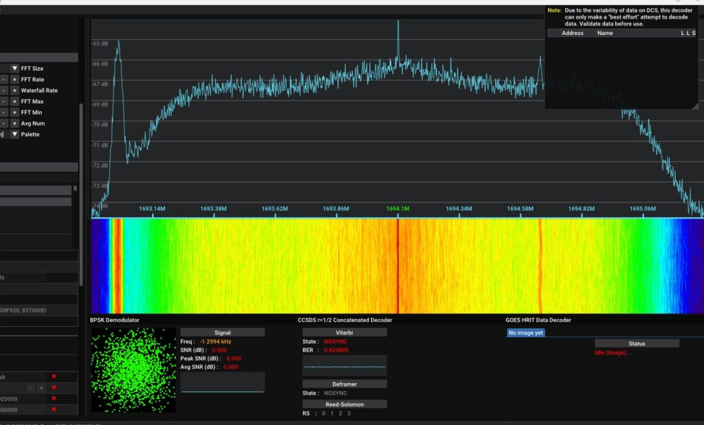
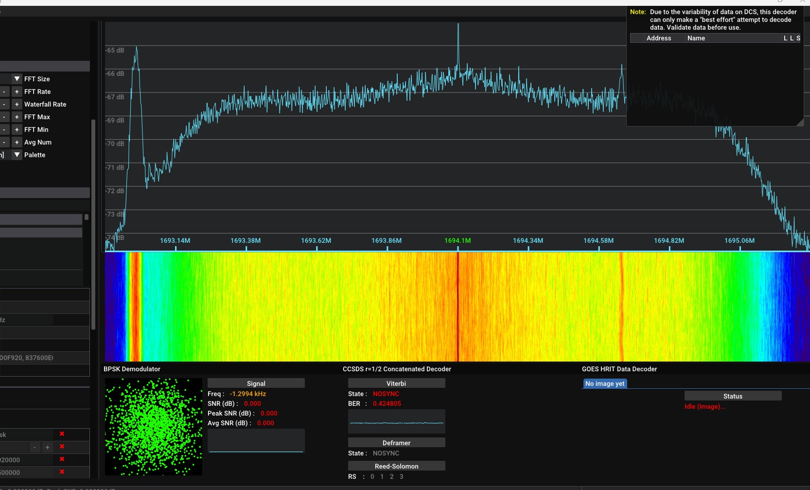
GOES 19 transmission, July 16 2026 11:30 UTC

What safe-hold actually is

Safe-hold (sometimes called “safe mode”) is an automated fallback state that spacecraft drop into when onboard fault-detection logic decides something is wrong enough that normal operations should stop. It’s not a manual “off switch” — it’s triggered by the satellite’s own flight software. When it engages:

  • The instrument payload gets powered down or put into a protective standby state — for GOES, that means the ABI imager (and other instruments) stop collecting and transmitting Earth-imaging and space-weather data. That’s why you’d see gaps in GeoColor loops, CONUS/full-disk imagery, GRB, GVAR-equivalent products, etc.
  • The spacecraft bus reorients itself to a stable, sun-pointed or otherwise thermally/power-safe attitude, prioritizing keeping solar panels charged and avoiding component damage over doing any mission work.
  • Non-essential systems are shed, and the satellite essentially “hunkers down” waiting for ground controllers to diagnose the problem and command it back to normal operations.
  • Recovery is a multi-step process: engineers first stabilize and assess the bus, then reactivate instruments one at a time, recalibrate them, and only then resume data downlink — this can take anywhere from hours to days depending on what tripped the safe-hold.
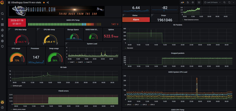
You can clearly see when GOES -19 shut off data transmission on July 15, 2026 in this display from my system.

Typical causes

The most common triggers, based on past GOES-series events, are:

  • Onboard computer resets or watchdog faults — for example, GOES-17 was dropped into safe-hold after an onboard computer reset triggered it, which shut off all instruments automatically.
  • Attitude control anomalies (a star tracker or gyro glitch that confuses the spacecraft about its orientation)
  • Power system faults (battery, solar array, or bus voltage irregularities)
  • Software/telemetry anomalies in flight computer logic
  • Radiation events — a solar particle event or energetic-particle hit flipping a bit or upsetting electronics (ironically something GOES itself is designed to monitor)
  • Ground command errors during routine maneuvers, though these are less common causes of unplanned safe-holds

Steps to Recovery


Step 1: Triage and stabilize the bus
The first priority isn’t the instruments — it’s making sure the spacecraft itself is safe. Engineers at the NOAA Satellite Operations Facility pull down full telemetry (power levels, attitude data, thermal readings, fault logs) to figure out exactly what tripped the safe-hold. They confirm the satellite is stable, solar-pointed, and drawing adequate power before touching anything else. This is largely diagnostic — reading logs, checking which specific fault flag fired, ruling causes in or out.

Step 2: Root-cause the trigger
Was it a computer reset, an attitude control fault, a radiation hit, a power anomaly? Engineers compare telemetry against the fault-detection thresholds that caused the safe-hold to fire, often cross-checking against space weather data (ironically, sometimes from the other operational GOES satellites) to see if a solar/energetic-particle event is implicated.

Step 3: Command the spacecraft out of safe-hold
Once the bus is confirmed stable and the cause is understood (or at least bounded), ground controllers send commands to return the satellite to normal pointing and power configuration.

Step 4: Reactivate instruments one at a time
Instruments come back online sequentially, not all at once — each one gets powered up, its performance is checked against expected baselines, and it’s recalibrated before being trusted for operational data. For the ABI imager specifically, this includes checking scan mirror function, detector cooling, and calibration targets.

Step 5: Resume and validate data streams
Only after instruments pass checkout does NOAA resume distributing products to AWIPS, GRB, PDA, and SWPC, and they’ll typically post incremental “Update #” notices as each stage completes — which is exactly the pattern you’re seeing on the OSPO status page right now.

GOES-16’s role as backup

Since GOES-19 took over the GOES-East operational slot in April 2025, GOES-16 has been kept in on-orbit storage as the standby spare rather than being deorbited. If GOES-19’s recovery drags out, NOAA’s playbook (used before with GOES-15 backing up GOES-17) is:

  • GOES-16 can be commanded out of storage mode and, if needed, repositioned or reactivated to fill the GOES-East role temporarily
  • It’s a real, human-rated fallback — not just a redundant transponder — since it’s a fully functional GOES-R-series satellite already in a stable orbital slot
  • This is precisely why NOAA maintains the “two operational + one spare” architecture across the fleet: it means a safe-hold on one satellite doesn’t leave a hemisphere blind while engineers work the problem
Post navigation

❮ Previous Post: SatDump 2.0

You may also like

News
Open Weather APT
November 2, 2024
News
End Of Life for NOAA 15 and 19?….not so fast…
June 13, 2025
Satellites
GOES-U, the 4th and Last of the GOES-R Series
March 26, 2024
Satellites
GOES-East Transition Plan
July 10, 2024

Please, Help Support USRadioguy.com

If you like what I do please support me on Ko-fi, It really means a lot, every bit helps!

Hardware Humor Imagery Processing Interesting stuff you should know! Launch News Life News Product Review Satellites Science Software Space Weather Uncategorized VLOG

Alphabetical Listing of all Pages on site:

  • 36-Hour Imagery Processing script
  • 3D animation of realtime data
  • A PORTABLE WWII ERA “MORALE RADIO”
  • About Me
  • ADS-B Reception
  • Allsky Camera
  • AN/GRR-5 THE ANGRY 5
  • BD-71 Field Switch Board and EE-8B Field Telephones
  • Current GOES 16 & 18 False Color Satellite Imagery
  • Custom Color Lookup Table
  • Custom Imagery Scripts for GOES
  • Daily 3D view of Earth
  • Daily Global Composites
  • Decoding EWS-G1 or GOES-13
  • Drifting a geostationary satellite
  • DRONE FUN
  • Even the kitchen sink
  • GEO-RING COMPOSITES
  • GEO-SAT PI FRAME
  • Geo-stationary Satellite Imagery Reception
  • Global Weather Data
  • GOES 19&18 – Last 96 Hours of Imagery
  • GOES BAND IMAGERY
  • GOES GRB Reception
  • GOES receiving in Windows for SatDump
  • GOES-18 Preparing for a new satellite
  • GOES-R Series Multimedia Tour
  • GOES-U (19) Countdown to Launch
  • GOES16 A full year of received imagery
  • Ground Station Map
  • High Resolution Imagery
  • Home
  • House History
  • HRIT/EMWIN & GRB
  • HRPT Satellite Tracking and Capture
  • Hubble Space Telescope Data Processing
  • Inmarsat Decoding
  • Layering Fire and Hotspot Data on Meteor Sat Imagery
  • Layering Geo-Spatial Fire Data into Satellite Imagery
  • Mesoscale Imagery Defined
  • METEOR M2- Series
  • MODIS VIIRS Global Coverage
  • My Other Interests
  • NASA, NOAA, Military, GOVT dish, and tower stations.
  • National Hurricane Data
  • Newsletter terms & conditions
  • NOAA & Meteor APT and LRPT RECEPTION
  • Online Satellite Imagery and Information
  • OpenHamClock on Windows
  • Optimizing a WIFI Grid Antenna for Maximum Efficiency
  • ORBITAL DYNAMICS 101
  • Orbitron, Gpredict, and PSTRotator with new TLE format
  • PI Based Broadcastify Server
  • Pi Based Picture Frame
  • Presentations
  • Privacy Policy
  • Programming the PI for goestools operation
  • R-100/URR 1944 MORALE RADIO
  • RADIO SET SCR-284
  • Rare Captures
  • Receiving GOES 18,19 with goestools
  • Receiving GOES HRIT with SATDUMP
  • Receiving the Funcube Amateur Satellite
  • Satdump for Meteor and NOAA decoding
  • Satellite Finder
  • Satellite Frequencies
  • Satellite Ground Stations
  • Satellite Tracking
  • Security
  • SETEC Astronomy
  • Solar Power for PI
  • South America GOES 16
  • Space Weather
  • Stray Light Zone (SLZ)
  • Thanks!
  • The quest for True Color Imagery
  • Tried and Tested Hardware
  • Usradioguy Blogs
  • Usradioguy Merchandise
  • USRadioguy Newsletter
  • USRadioguy VLOGS
  • USRADIOGUY Youtube Page
  • VIBRATOR CONVERSION MODULE
  • Viterbi, R/S Errors, Packets
  • VS-3 VIBRATOR CONVERSION
  • What is RTL-SDR?
  • WWII Audio Page
  • WWII K-24 Aerial Camera
  • WWII RADIO
  • WxtoImg Fix
  • Your very Own Weather Satellite
  • Zombie Satellites

Hardware Humor Imagery Processing Interesting stuff you should know! Launch News Life News Product Review Satellites Science Software Space Weather Uncategorized VLOG

Satellite And Weather Related Feeds

  • CIMSS Satellite Blog
  • USRadioguy.com
  • wildfires
  • NASA Science
  • SPC Particularly Dangerous Situation (PDS) Tornado/Severe Thunderstorm Watch
  • satellites
  • Satellites News -- ScienceDaily
  • Satellite Liaison Blog
Long-range transport of smoke from wildfires in Canada and northeastern Minnesota
VIIRS Day/Night Band Observations of the Minnesota/Ontario Wildfires
Satellite Observations of a Heat Wave
GOES-19 in Safe Hold
SatDump 2.0
SatDump 2.0
WXtoIMG: A Legacy in Weather Satellite Decoding
The fire cycle
NOAA's wildfire detection system a game-changer for record-breaking Morrill fire
Media availability: NOAA incident meteorologists train for wildfire season
Ontario Wildfire Smoke Moves East
Curiosity Finds Evidence of an Ancient Sandstorm
NASA’s Perseverance Rover Provides Sweeping View of Broom Point
SPC PDS Severe Thunderstorm Watch 285
NOAA’s SOLAR-1 enters new era of space weather monitoring
Artemis II returns: How NOAA helped protect astronauts during the 10-day NASA mission
NOAA satellites helped rescue 300 people in 2025
NASA's Hubble spots a stellar sparkler for the Fourth of July
NASA's Hubble captures a crimson stellar nursery sparkling with blue and white stars
NASA's Hubble captures a star-spangled sea of 500,000 stars
Retrospective Case: Texas Hill Country All-Sky Total Precipitable Water
A Satellite Perspective of Valley Fog in West Virginia
Tropical Storm Arthur Kicks Off 2026 Atlantic Hurricane Season, Delivers Flooding Rains
  • Facebook Geo Stationary Satellites
  • Usradioguy Facebook
  • Instagram
  • Reddit
  • Github
  • Linkedin

Copyright © 2025 USRadioguy.com - All Rights Reserved. All material protected by Fair Use Section 107 of the Copyright Act. This site is Verified and Secured with 256 bit SSL encryption

Help Fund USRadioguy.com

USRadioguy Needs Your Help