Skip to content
USRADIOGUY

USRadioguy.com

Welcome to USRadioguy.com – Unlocking the Potential of Software Defined Radio

  • Home
    • Home of USRadioguy
    • USRadioguy Newsletter
    • Tried and Tested Hardware
    • What is RTL-SDR?
    • Global Weather Data
  • Satellite Reception
    • Geo Stationary Satellites
      • Geo-stationary Satellite Imagery Reception
      • GOESTOOLS on the PI
      • Update Goestools for GOES 18,19
      • Receiving GOES with SatDump CLI Mode
      • GOES receiving in Windows for SatDump GUI
      • Decoding EWS-G1/EWS-G2
      • GOES GRB Reception WIP
      • Optimizing a WIFI Grid Antenna for Maximum Efficiency
    • APT Satellites
      • APT RECEPTION
      • Satdump for Meteor and NOAA decoding
      • METEOR M2- Series
      • WxtoImg Fix
      • Converting to new TLE format
      • Layering Fire and Hotspot Data on Meteor Sat Imagery
      • HRPT Satellite Tracking and Capture
    • Receiving Other Satellites
      • Inmarsat Decoding
      • Receiving the Funcube Amateur Satellite
    • User Maps and Dish Pointers
      • Satellite Dish Pointer
      • User Global Ground Station Maps
      • Usermap rendered with Cesium
      • Global Map of Govt Dish Stations
    • Satellite Details & Information
      • ORBITAL DYNAMICS 101
      • HRIT/EMWIN & GRB Defined
      • Mesoscale Imagery Defined
      • Viterbi, R/S Errors, Packets
      • GOES BAND IMAGERY
      • Stray Light Zone (SLZ)
      • Drifting a geostationary satellite
      • GOES-R Series Multimedia Tour
      • Online Satellite Imagery and Information
      • Satellite Frequencies
      • Solar and Space Weather
  • Satellite Imagery
    • IMAGERY- Current GOES East & West HRIT Satellite Imagery
    • IMAGERY- GOES 16&18 – Past 96 Hours of Imagery
    • High Resolution Imagery
    • Daily 3D view of Earth
    • NOAA APT Satellite imagery
    • PlanetMaker
    • GOES16 A full year of received imagery
  • Imagery Processing
    • Custom Color Lookup Table & Gradients
    • GOES-R Custom Imagery Scripts
    • Global geo-ring composites
    • MODIS VIIRS Global Coverage
    • 3D Satellite Tracking
    • The quest for True Color Imagery
    • 3D animation of realtime data
    • Layering Geo-Spatial Fire Data into Satellite Imagery
    • Orbital dynamics and the Moon
    • National Hurricane Data
  • News, VLOGS & BLOGS
    • News & USRadioguy Blogs
    • USRadioguy VLOGS
  • Project Lab
    • Orbital Information and Visualizations
      • Enhanced Planet Earth
      • Satellites in Orbit
      • Solar System
      • Objects in Orbit
    • Current Station Weather
      • Current Groundstation Weather
      • Global Weather Data
      • Space Weather
    • WWII RADIO
      • WWII K-24 Aerial Camera
      • WWII RADIO
      • RADIO SET SCR-284
      • VS-3 VIBRATOR CONVERSION
      • VIBRATOR CONVERSION MODULE
      • BD-71 Field Switch Board and EE-8B Field Telephones
      • R-100/URR 1944 MORALE RADIO
      • A PORTABLE WWII ERA “MORALE RADIO”
      • AN/GRR-5 THE ANGRY 5
      • WWII Audio Page
    • Raspberry Pi Projects
      • ADS-B Reception
      • Allsky Camera
      • Pi Based Picture Frame
      • PI Based Broadcastify Server
      • Solar Power for PI
    • Hubble Space Telescope Data Processing
    • Zombie Satellites
    • DRONES
  • About Me
    • About Usradioguy
      • SETEC Astronomy
    • Tried and Tested Hardware
    • Rare Captures
    • My Other Interests
    • Presentations
    • Merchandise
    • Privacy Policy
  • Home
  • Science
  • The Kessler Syndrome

The Kessler Syndrome

Posted on July 6, 2024September 23, 2024 By Carl 2 Comments on The Kessler Syndrome
Interesting stuff you should know!, News, Satellites, Science, Space Weather

Loading

Updated July 6, 2024

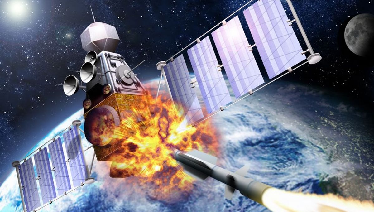
On 11 January 2007, China conducted an anti-satellite missile test. A China weather satellite—the FY-1C polar-orbiting satellite of the Fengyun series, at an altitude of 865 kilometers (537 mi), with a mass of 750 kilograms (1,650 lb) —was destroyed by a kinetic kill vehicle traveling at a speed of 8 km/s (18,000 mph) in the opposite direction. A Head-On Engagement attack like this has the advantage, however, of greatly increasing the effective range at which missiles or kinetic weapons can be used. Many kinetic weapons have an effective range in a head-on engagement on the order of three or four times or more of that in a tail-chase engagement. The target satellite effectively flies right into the weapon(s) fired at it. The kinetic weapon China launched was a multistage solid-fuel missile from Xichang Satellite Launch Center.

On 27 March 2019, India tested an anti-satellite weapon during an operation code-named Mission Shakti  The target of the test was a satellite in a low Earth orbit, which was hit by a kinetic kill vehicle. The interceptor struck a test satellite at a 283-kilometers (176 mi) altitude in low earth orbit (LEO), The missile reportedly hit the satellite with an accuracy of less than 10 cm!

Orbital Analysis of the Shakti test.


In April 2011, debris from the 2007 Chinese test passed 6 kilometers (3.7 mi) away from the International Space Station.

As of April 2019, 3000 of the 10,000 pieces of space debris routinely tracked by the US Military as a threat to the International Space Station were known to have originated from the 2007 Chinese satellite shootdown. But to be clear, China is not the only actor to purposefully shoot down a satellite. The US, Russia, and India all have conducted tests in anti-satellite operations

16 November 2021 Russia carried out a missile test, destroying one of its own satellites. The action has caused international outrage because the debris could threaten the International Space Station (ISS) and satellites in low-Earth orbit. The missile destroyed an old Soviet spy satellite, called Kosmos 1408, which was once part of Russia’s Tselina radio signals surveillance program. The debris field from the A-Sat test is found at an altitude of between 440km and 520km above Earth, threatening the ISS, China’s Tiangong space station, and other spacecraft.


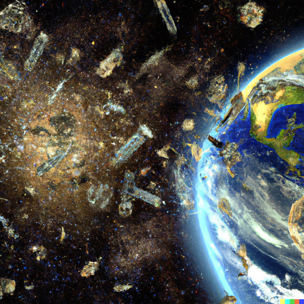
Orbital Debris: A Growing Threat to Spacecraft Operations

The increasing number of defunct satellites, spent rocket bodies, and debris fragments in Earth orbit poses a significant threat to operational spacecraft. This paper explores the current state of orbital debris, its potential for catastrophic collisions, and the need for mitigation strategies.

Since the launch of Sputnik 1 in 1957, human space activity has resulted in the placement of nearly 10,000 satellites into Earth orbit. However, a large portion of these (approximately 73%) are no longer operational. This, coupled with spent rocket bodies and collision-generated fragments, has created a growing population of orbital debris.

Debris Population and Characteristics: The current catalog maintained by the military tracks objects larger than 10 cm, with estimates suggesting millions of debris particles exceeding 1 mm and trillions exceeding 1 micron. This debris originates from various sources, including defunct satellites, rocket bodies, and collision byproducts like bolts, paint flakes, and even a functional Tesla Roadster launched in 2018.

Collision Risks and Consequences: High-velocity impacts from even small debris objects pose a significant threat to operational spacecraft. A 1 kg object impacting at 10 km/s could catastrophically fragment a 1,000 kg spacecraft, creating a cascading effect of further collisions and debris generation.

The ever-growing population of orbital debris necessitates the development and implementation of effective mitigation strategies. These strategies could include debris removal missions, collision avoidance maneuvers, and the design of more sustainable spacecraft construction and disposal practices.

This chain reaction is known as the Kessler Syndrome.

The study, titled “Collision Frequency of Artificial Satellites: The Creation of a Debris Belt (opens in new tab),” Kessler and co-author Burton Cour-Palais noted that the likelihood of satellite collisions increases as more and more spacecraft are lofted to orbit. And each such smashup would have an outsized impact on the orbital environment.

Kessler’s analysis divided the problem into three parts. With a low-enough density, the addition of debris by impacts is slower than their decay rate and the problem is not significant. Beyond that is a critical density, where additional debris leads to additional collisions. At densities beyond this critical mass production exceeds decay, leading to a cascading chain reaction reducing the orbiting population to small objects (several centimeters in size) and increasing the hazard of space activity.

The Kessler syndrome is troublesome because of the domino effect and feedback runaway wherein impacts between objects of sizable mass spall off debris from the force of the collision. The fragments can then hit other objects, producing even more space debris: if a large enough collision or explosion was to occur, such as between a space station and a defunct satellite, or as the result of hostile actions in space, then the resulting debris cascade could make prospects for the long-term viability of satellites in particular low Earth orbits extremely low. However, even a catastrophic Kessler scenario at LEO would pose minimal risk for launches continuing past LEO, or satellites traveling at medium Earth orbit (MEO) or geosynchronous orbit (GEO). The catastrophic scenarios predict an increase in the number of collisions per year, as opposed to a physically impassable barrier to space exploration that occurs in higher orbits.

SpaceX’s Starlink program raises concern among many experts about significantly worsening the possibility of Kessler Syndrome due to the large number of satellites the program aims to place in Low Earth Orbit. The Space X program’s goal alone will more than double the satellites currently in Low Earth Orbit!

The first person to truly study that space pollution posed a strange form of high-speed environmental damage was Don Kessler, a NASA astrophysicist who had helped assess the International Space Station’s vulnerability to debris. He determined that the problem if ignored could destroy all the satellites that orbit near the Earth—a loss that would affect pretty much everything on an earth-bound species that increasingly rely on space. Communication systems would fail; scientific instruments—to study climate, or pandemics, say—would become inoperable. Spy satellites would fail, it could extend to GPS satellites as well. The losses could be measured in hundreds of billions of dollars, and perhaps in lives, too.

– In the video below, the distribution of debris following the Cosmos-Iridium collision.


In the void of space, a chaos reigns,
A field of debris, a deadly remains.
The Kessler Effect, a nightmare scenario,
A cascade of collisions, a cosmic rodeo.

Satellites and junk, a dangerous mix,
Colliding in space, creating a fix.
A domino effect, with each crash,
Creating more debris, an endless stash.

A future of space travel, uncertain and bleak,
As the Kessler Effect, its toll does wreak. Communications lost, navigation impaired, Astronauts in danger, with no one to be spared.

The economy suffers, as services shut down, GPS, weather, and more, all come tumbling down.
The internet, and its endless array,
Disrupted, as space debris gets in the way.

And as the debris field grows, ever more dense, The Kessler Effect, a relentless offense.
A future of space, once bright and clear,
Now mired in debris, and all that we fear.

So let us work together, to avert this fate,
To clean up space, before it's too late.
For the Kessler Effect, a warning we heed,
A lesson to learn, a call to take heed.

Tags: Satellite Space Weather

Post navigation

❮ Previous Post: Monitoring Space Weather
Next Post: GEONETCast Americas ❯

You may also like

News
Life after GOES, The GEO XO mission
January 25, 2024
Satellites
Atlas V assembled to launch GOES-T
February 7, 2022
Satellites
Goestools for Windows
July 14, 2023
Launch News
GOES-U Launch Day
June 25, 2024

2 thoughts on “The Kessler Syndrome”

  1. David Finkleman says:
    May 8, 2023 at 1:55 pm

    When there is much more debris than satellites there will be many more collisions of debris with other debris than with satellites. Each such collision will generate more, but smaller debris. More debris means more and more collisions among the fragments and less and less debris from collisions with satellites. Wont this drive the situation to equilibrium at a constant launch rate? Nothing in nature really cascades to unrecoverable catastrophe. Even feedback in sound systems doesn’t screech indefinitely. Speaker or other components blow out before that. The infinity is abn artifact of simplified models”

    1. Carl says:
      May 9, 2023 at 3:20 pm

      Hi David, I would say that the effect would not of course last infinitely. Some estimates are that objects and debris could remain in orbit for hundreds of years before they would burn up in the atmosphere. Of course, those that would experience atmospheric drag would enter the atmosphere much earlier. Orbital decay is much slower at altitudes where atmospheric drag is insignificant. Slight atmospheric drag, lunar perturbation, and solar wind drag can gradually bring debris down to lower altitudes where fragments finally re-enter, but this process can take millennia at very high altitudes. The anti-satellite test that China did in 2007 resulted in debris orbiting the Earth with a mean altitude above 850 kilometers, and will likely remain in orbit for decades or centuries.
      The NASA Orbital Debris Program Office has a ton of data on this

Comments are closed.

Please, Help Support USRadioguy.com

If you like what I do please support me on Ko-fi, It really means a lot, every bit helps!

Hardware Humor Imagery Processing Interesting stuff you should know! Launch News Life News Product Review Satellites Science Software Space Weather Uncategorized VLOG

Alphabetical Listing of all Pages on site:

  • 36-Hour Imagery Processing script
  • 3D animation of realtime data
  • A PORTABLE WWII ERA “MORALE RADIO”
  • About Me
  • ADS-B Reception
  • Allsky Camera
  • AN/GRR-5 THE ANGRY 5
  • BD-71 Field Switch Board and EE-8B Field Telephones
  • Current GOES 16 & 18 False Color Satellite Imagery
  • Custom Color Lookup Table
  • Custom Imagery Scripts for GOES
  • Daily 3D view of Earth
  • Daily Global Composites
  • Decoding EWS-G1 or GOES-13
  • Drifting a geostationary satellite
  • DRONE FUN
  • Even the kitchen sink
  • GEO-RING COMPOSITES
  • GEO-SAT PI FRAME
  • Geo-stationary Satellite Imagery Reception
  • Global Weather Data
  • GOES 19&18 – Last 96 Hours of Imagery
  • GOES BAND IMAGERY
  • GOES GRB Reception
  • GOES receiving in Windows for SatDump
  • GOES-18 Preparing for a new satellite
  • GOES-R Series Multimedia Tour
  • GOES-U (19) Countdown to Launch
  • GOES16 A full year of received imagery
  • Ground Station Map
  • High Resolution Imagery
  • Home
  • House History
  • HRIT/EMWIN & GRB
  • HRPT Satellite Tracking and Capture
  • Hubble Space Telescope Data Processing
  • Inmarsat Decoding
  • Layering Fire and Hotspot Data on Meteor Sat Imagery
  • Layering Geo-Spatial Fire Data into Satellite Imagery
  • Mesoscale Imagery Defined
  • METEOR M2- Series
  • MODIS VIIRS Global Coverage
  • My Other Interests
  • NASA, NOAA, Military, GOVT dish, and tower stations.
  • National Hurricane Data
  • Newsletter terms & conditions
  • NOAA & Meteor APT and LRPT RECEPTION
  • Online Satellite Imagery and Information
  • Optimizing a WIFI Grid Antenna for Maximum Efficiency
  • ORBITAL DYNAMICS 101
  • Orbitron, Gpredict, and PSTRotator with new TLE format
  • PI Based Broadcastify Server
  • Pi Based Picture Frame
  • Presentations
  • Privacy Policy
  • Programming the PI for goestools operation
  • R-100/URR 1944 MORALE RADIO
  • RADIO SET SCR-284
  • Rare Captures
  • Receiving GOES 18,19 with goestools
  • Receiving GOES HRIT with SATDUMP
  • Receiving the Funcube Amateur Satellite
  • Satdump for Meteor and NOAA decoding
  • Satellite Finder
  • Satellite Frequencies
  • Satellite Ground Stations
  • Satellite Tracking
  • Security
  • SETEC Astronomy
  • Solar Power for PI
  • South America GOES 16
  • Space Weather
  • Stray Light Zone (SLZ)
  • Thanks!
  • The quest for True Color Imagery
  • Tried and Tested Hardware
  • Usradioguy Blogs
  • Usradioguy Merchandise
  • USRadioguy Newsletter
  • USRadioguy VLOGS
  • USRADIOGUY Youtube Page
  • VIBRATOR CONVERSION MODULE
  • Viterbi, R/S Errors, Packets
  • VS-3 VIBRATOR CONVERSION
  • What is RTL-SDR?
  • WWII Audio Page
  • WWII K-24 Aerial Camera
  • WWII RADIO
  • WxtoImg Fix
  • Zombie Satellites

Hardware Humor Imagery Processing Interesting stuff you should know! Launch News Life News Product Review Satellites Science Software Space Weather Uncategorized VLOG

Satellite And Weather Related Feeds

  • CIMSS Satellite Blog
  • USRadioguy.com
  • wildfires
  • NASA Earth Observatory
  • SPC Particularly Dangerous Situation (PDS) Tornado/Severe Thunderstorm Watch
  • satellites
  • Satellites News -- ScienceDaily
  • Satellite Liaison Blog
Wildfire in Ontario produces a large pyrocumulonimbus cloud
American Samoa’s Wettest Year Gets Wetter
Deadly flash flooding in Ruidoso, New Mexico
Global cloud layers on your Devices
End Of Life for NOAA 15 and 19?….not so fast…
Vitality GOES
Vitality GOES
The fire cycle
Unmasking the complicated chemistry of wildfire smoke: What's in it?
NOAA unveils powerful convergence of AI and science with revolutionary Next-Generation Fire System technology
The Salty Lake of Gas Hure
Greenland’s Bejeweled Ice Sheet
Manitoba Burning
Manitoba Burning
SPC PDS Severe Thunderstorm Watch 399
Five historically huge solar events
65 years since the world’s first weather satellite
Investing in America: NOAA's Science, Service and Stewardship in Action
Earth’s weather satellites just spent 10 years watching Venus — here’s what they found
Record-breaking 10-billion-year radio halo just rewrote the universe’s origin story
Massive thread of hot gas found linking galaxies — and it’s 10 times the mass of the Milky Way
The Need for Speed: OCTANE Cloud-Top Winds at SPC
Summer Storms, Flooding Target Mid-Atlantic
Southwest Thunderstorms – Late June 2025
  • Facebook Geo Stationary Satellites
  • Usradioguy Facebook
  • Instagram
  • Reddit
  • Github
  • Linkedin

Copyright © 2025 USRadioguy.com - All Rights Reserved. All material protected by Fair Use Section 107 of the Copyright Act. This site is Verified and Secured with 256 bit SSL encryption