Skip to content
USRADIOGUY

USRadioguy.com

Welcome to USRadioguy.com – Unlocking the Potential of Software Defined Radio

  • Home
    • Home of USRadioguy
    • USRadioguy Newsletter
    • Tried and Tested Hardware
    • What is RTL-SDR?
    • Global Weather Data
  • Satellite Reception
    • Geo Stationary Satellites
      • Geo-stationary Satellite Imagery Reception
      • GOESTOOLS on the PI
      • Update Goestools for GOES 18,19
      • Receiving GOES with SatDump CLI Mode
      • GOES receiving in Windows for SatDump GUI
      • Decoding EWS-G1/EWS-G2
      • GOES GRB Reception WIP
      • Optimizing a WIFI Grid Antenna for Maximum Efficiency
    • APT Satellites
      • APT RECEPTION
      • Satdump for Meteor and NOAA decoding
      • METEOR M2- Series
      • WxtoImg Fix
      • Converting to new TLE format
      • Layering Fire and Hotspot Data on Meteor Sat Imagery
      • HRPT Satellite Tracking and Capture
    • Receiving Other Satellites
      • Inmarsat Decoding
      • Receiving the Funcube Amateur Satellite
    • User Maps and Dish Pointers
      • Satellite Dish Pointer
      • User Global Ground Station Maps
      • Usermap rendered with Cesium
      • Global Map of Govt Dish Stations
    • Satellite Details & Information
      • ORBITAL DYNAMICS 101
      • HRIT/EMWIN & GRB Defined
      • Mesoscale Imagery Defined
      • Viterbi, R/S Errors, Packets
      • GOES BAND IMAGERY
      • Stray Light Zone (SLZ)
      • Drifting a geostationary satellite
      • GOES-R Series Multimedia Tour
      • Online Satellite Imagery and Information
      • Satellite Frequencies
      • Solar and Space Weather
  • Satellite Imagery
    • IMAGERY- Current GOES East & West HRIT Satellite Imagery
    • IMAGERY- GOES 16&18 – Past 96 Hours of Imagery
    • High Resolution Imagery
    • Daily 3D view of Earth
    • NOAA APT Satellite imagery
    • PlanetMaker
    • GOES16 A full year of received imagery
  • Imagery Processing
    • Custom Color Lookup Table & Gradients
    • GOES-R Custom Imagery Scripts
    • Global geo-ring composites
    • MODIS VIIRS Global Coverage
    • 3D Satellite Tracking
    • The quest for True Color Imagery
    • 3D animation of realtime data
    • Layering Geo-Spatial Fire Data into Satellite Imagery
    • Orbital dynamics and the Moon
    • National Hurricane Data
  • News, VLOGS & BLOGS
    • News & USRadioguy Blogs
    • USRadioguy VLOGS
  • Project Lab
    • Orbital Information and Visualizations
      • Enhanced Planet Earth
      • Satellites in Orbit
      • Solar System
      • Objects in Orbit
    • Current Station Weather
      • Current Groundstation Weather
      • Global Weather Data
      • Space Weather
    • WWII RADIO
      • WWII K-24 Aerial Camera
      • WWII RADIO
      • RADIO SET SCR-284
      • VS-3 VIBRATOR CONVERSION
      • VIBRATOR CONVERSION MODULE
      • BD-71 Field Switch Board and EE-8B Field Telephones
      • R-100/URR 1944 MORALE RADIO
      • A PORTABLE WWII ERA “MORALE RADIO”
      • AN/GRR-5 THE ANGRY 5
      • WWII Audio Page
    • Raspberry Pi Projects
      • ADS-B Reception
      • Allsky Camera
      • Pi Based Picture Frame
      • PI Based Broadcastify Server
      • Solar Power for PI
    • Hubble Space Telescope Data Processing
    • Zombie Satellites
    • DRONES
  • About Me
    • About Usradioguy
      • SETEC Astronomy
    • Tried and Tested Hardware
    • Rare Captures
    • My Other Interests
    • Presentations
    • Merchandise
    • Privacy Policy
  • Home
  • Science
  • Monitoring Space Weather
SUVI imagery from GOES-16

Monitoring Space Weather

Posted on July 6, 2024July 10, 2024 By Carl
Imagery Processing, Satellites, Science

Loading

The Importance of Monitoring Space Weather

Update July 6th, 2024

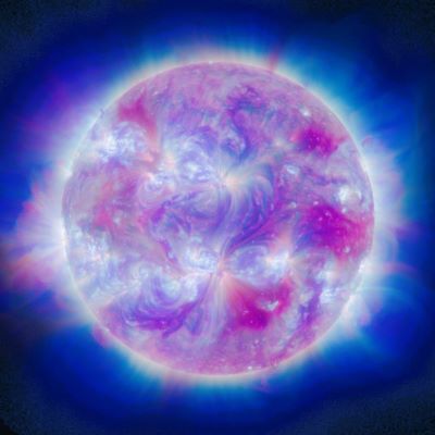
The sun is a dynamic and active star, and its activity can significantly impact Earth. The sun’s atmosphere is made up of hot, ionized plasma, and the sun’s magnetic field is constantly changing. These changes can lead to the formation of solar storms, which are large eruptions of plasma and magnetic fields from the sun.

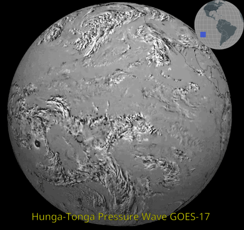
Solar storms can have a variety of effects on Earth. They can disrupt radio communications, damage satellites, and even cause power outages. In extreme cases, solar storms can even affect the Earth’s atmosphere, causing auroras to be seen at lower latitudes than usual.

For this reason, it is important to monitor space weather so that we can be prepared for potential disruptions. The GOES-R series of satellites is a key part of our space weather monitoring system. These satellites provide continuous observations of the sun and its environment, and they help us to track the development of solar storms.

How GOES-R Satellites Work

The GOES-R series of satellites are weather satellites operated by NOAA. These satellites are equipped with a variety of instruments that allow them to observe the sun and its environment. Some of the instruments on the GOES-R satellites include:

  • A visible light camera that can image the sun’s surface.
  • An extreme ultraviolet (SUVI) imager that can image the sun’s atmosphere.
  • A magnetometer that can measure the strength and direction of the sun’s magnetic field.
  • A particle detector that can measure the flux of charged particles from the sun.
  • NOTE: The current GOES-19 spacecraft has a revolutionary new instrument called CCOR, the only GOES series spacecraft to carry this.

The data from these instruments is used to track the development of solar storms and to forecast their impact on Earth. The GOES-R satellites provide a critical early warning system that helps us to protect our technology and infrastructure from the effects of space weather.

The Carrington Event

The Carrington Event (CE) of 1859 serves as a historical precedent for the disruptive potential of extreme space weather. This geomagnetic storm, triggered by a potent coronal mass ejection (CME), induced widespread technological malfunctions on Earth. Telegraph networks globally became inoperable, and auroral displays extended to unusually low geomagnetic latitudes, reaching even tropical regions.

While the CE stands as a singular event in recorded history for its intensity, it is not an isolated occurrence. Numerous smaller solar storms have transpired in recent years, causing varying degrees of technological disruptions. As our dependence on increasingly complex technological infrastructure intensifies, preparedness for a future major space weather event becomes a critical imperative.

The Future of Space Weather Monitoring

The GOES-R series of satellites is a significant advancement in space weather monitoring. These satellites provide more comprehensive and accurate observations of the sun and its environment than ever before. However, there is still more that we can do to improve our understanding of space weather and to protect ourselves from its effects.

One area of research that is receiving a lot of attention is the development of better space weather forecasting models. These models will help us to predict the impact of solar storms on Earth with greater accuracy. Another area of research is the development of new technologies to protect our technology and infrastructure from the effects of space weather.

As we continue to learn more about space weather, we will be better able to protect ourselves from its effects. The GOES-R series of satellites is a critical part of this effort, and it will help us to stay ahead of the next major space weather event. The new satellite series from NOAA, the GEO-XO program that is slated to replace the GOES-R series will bring with it even more space weather resources and instruments.
NOTE: The current GOES-19 spacecraft has a revolutionary new instrument called CCOR, the only GOES series spacecraft to carry this.

Resources

  • USRadioguy Space Weather Page: https://usradioguy.com/space-weather/
  • NOAA Space Weather Prediction Center: https://www.swpc.noaa.gov/
  • GOES-R Series of Satellites: https://www.goes-r.gov/
  • The Carrington Event: https://en.wikipedia.org/wiki/Carrington_Event
  • https://www.swpc.noaa.gov/content/space-weather-enthusiasts-dashboard

Additional Information

  • Space weather is a term used to describe the conditions in the space environment that can affect the Earth and its inhabitants. These conditions can be caused by solar activity, such as solar flares and coronal mass ejections (CMEs).
  • Solar flares are sudden bursts of energy from the sun’s surface. They can emit high-energy radiation, which can disrupt radio communications and damage satellites.
  • CMEs are large eruptions of plasma and magnetic field from the sun’s atmosphere. They can travel at speeds of up to millions of miles per hour and can cause geomagnetic storms on Earth.
  • Geomagnetic storms are disturbances in the Earth’s magnetic field caused by the interaction of the solar wind with the Earth’s atmosphere. They can disrupt power grids, communication systems, and navigation systems.
  • Monitoring of Space weather for the satellite enthusiast can be done, but requires a minimum of a GRB receiving station.
  • The GOES-R series of satellites is a set of four weather satellites operated by NOAA. These satellites are equipped with a variety of instruments that allow them to observe the sun
Tags: GOES-19 Satellite Space Weather

Post navigation

❮ Previous Post: Kraken Discovery Dish Progress
Next Post: The Kessler Syndrome ❯

You may also like

Interesting stuff you should know!
Update – Goes 16 to19 Transition to Operations
March 4, 2025
The Seasons
Imagery Processing
The Seasons
March 19, 2024
Imagery Processing
Argh-who took a chunk out of my image?
May 5, 2024
Life
Mapping Ground Stations
February 6, 2022

Please, Help Support USRadioguy.com

If you like what I do please support me on Ko-fi, It really means a lot, every bit helps!

Hardware Humor Imagery Processing Interesting stuff you should know! Launch News Life News Product Review Satellites Science Software Space Weather Uncategorized VLOG

Alphabetical Listing of all Pages on site:

  • 36-Hour Imagery Processing script
  • 3D animation of realtime data
  • A PORTABLE WWII ERA “MORALE RADIO”
  • About Me
  • ADS-B Reception
  • Allsky Camera
  • AN/GRR-5 THE ANGRY 5
  • BD-71 Field Switch Board and EE-8B Field Telephones
  • Current GOES 16 & 18 False Color Satellite Imagery
  • Custom Color Lookup Table
  • Custom Imagery Scripts for GOES
  • Daily 3D view of Earth
  • Daily Global Composites
  • Decoding EWS-G1 or GOES-13
  • Drifting a geostationary satellite
  • DRONE FUN
  • Even the kitchen sink
  • GEO-RING COMPOSITES
  • GEO-SAT PI FRAME
  • Geo-stationary Satellite Imagery Reception
  • Global Weather Data
  • GOES 19&18 – Last 96 Hours of Imagery
  • GOES BAND IMAGERY
  • GOES GRB Reception
  • GOES receiving in Windows for SatDump
  • GOES-18 Preparing for a new satellite
  • GOES-R Series Multimedia Tour
  • GOES-U (19) Countdown to Launch
  • GOES16 A full year of received imagery
  • Ground Station Map
  • High Resolution Imagery
  • Home
  • House History
  • HRIT/EMWIN & GRB
  • HRPT Satellite Tracking and Capture
  • Hubble Space Telescope Data Processing
  • Inmarsat Decoding
  • Layering Fire and Hotspot Data on Meteor Sat Imagery
  • Layering Geo-Spatial Fire Data into Satellite Imagery
  • Mesoscale Imagery Defined
  • METEOR M2- Series
  • MODIS VIIRS Global Coverage
  • My Other Interests
  • NASA, NOAA, Military, GOVT dish, and tower stations.
  • National Hurricane Data
  • Newsletter terms & conditions
  • NOAA & Meteor APT and LRPT RECEPTION
  • Online Satellite Imagery and Information
  • Optimizing a WIFI Grid Antenna for Maximum Efficiency
  • ORBITAL DYNAMICS 101
  • Orbitron, Gpredict, and PSTRotator with new TLE format
  • PI Based Broadcastify Server
  • Pi Based Picture Frame
  • Presentations
  • Privacy Policy
  • Programming the PI for goestools operation
  • R-100/URR 1944 MORALE RADIO
  • RADIO SET SCR-284
  • Rare Captures
  • Receiving GOES 18,19 with goestools
  • Receiving GOES HRIT with SATDUMP
  • Receiving the Funcube Amateur Satellite
  • Satdump for Meteor and NOAA decoding
  • Satellite Finder
  • Satellite Frequencies
  • Satellite Ground Stations
  • Satellite Tracking
  • Security
  • SETEC Astronomy
  • Solar Power for PI
  • South America GOES 16
  • Space Weather
  • Stray Light Zone (SLZ)
  • Thanks!
  • The quest for True Color Imagery
  • Tried and Tested Hardware
  • Usradioguy Blogs
  • Usradioguy Merchandise
  • USRadioguy Newsletter
  • USRadioguy VLOGS
  • USRADIOGUY Youtube Page
  • VIBRATOR CONVERSION MODULE
  • Viterbi, R/S Errors, Packets
  • VS-3 VIBRATOR CONVERSION
  • What is RTL-SDR?
  • WWII Audio Page
  • WWII K-24 Aerial Camera
  • WWII RADIO
  • WxtoImg Fix
  • Zombie Satellites

Hardware Humor Imagery Processing Interesting stuff you should know! Launch News Life News Product Review Satellites Science Software Space Weather Uncategorized VLOG

Satellite And Weather Related Feeds

  • CIMSS Satellite Blog
  • USRadioguy.com
  • wildfires
  • NASA Earth Observatory
  • SPC Particularly Dangerous Situation (PDS) Tornado/Severe Thunderstorm Watch
  • satellites
  • Satellites News -- ScienceDaily
  • Error
Using Polar2grid and Direct Broadcast files to create imagery
Cirrus over the western Great Lakes
Wildfire in Saskatchewan produces a pyrocumulonimbus cloud
End Of Life for NOAA 15,18,19?….not so fast…
GOES-19 now GOES-EAST
GOES 19 Operational Schedule
The fire cycle
March was nation's 6th warmest on record
Podcast: Could the LA Wildfires harm California's marine life?
Mapping the Tiny Plankton That Feed Giant Right Whales
Lights of Southeast Asia
The Arches That Salt Built
SPC PDS Tornado Watch 98
Five historically huge solar events
65 years since the world’s first weather satellite
Investing in America: NOAA's Science, Service and Stewardship in Action
Satellite measures CO2 and NO2 simultaneously from power plant emissions for the first time
Existing international law can help secure peace and security in outer space
Small, faint and 'unexpected in a lot of different ways': Astronomers make galactic discovery

RSS Error: WP HTTP Error: cURL error 28: Connection timed out after 10003 milliseconds

  • Facebook Geo Stationary Satellites
  • Usradioguy Facebook
  • Instagram
  • Reddit
  • Github
  • Linkedin

Copyright © 2025 USRadioguy.com - All Rights Reserved. All material protected by Fair Use Section 107 of the Copyright Act. This site is Verified and Secured with 256 bit SSL encryption