Skip to content
USRADIOGUY

USRadioguy.com

Welcome to USRadioguy.com – Unlocking the Potential of Software Defined Radio

  • Home
    • Home of USRadioguy
    • USRadioguy Newsletter
    • Tried and Tested Hardware
    • What is RTL-SDR?
    • Global Weather Data
  • Satellite Reception
    • Geo Stationary Satellites
      • Geo-stationary Satellite Imagery Reception
      • GOESTOOLS on the PI
      • Update Goestools for GOES 18,19
      • Receiving GOES with SatDump CLI Mode
      • GOES receiving in Windows for SatDump GUI
      • Decoding EWS-G1/EWS-G2
      • GOES GRB Reception WIP
      • Optimizing a WIFI Grid Antenna for Maximum Efficiency
    • APT Satellites
      • APT RECEPTION
      • Satdump for Meteor and NOAA decoding
      • METEOR M2- Series
      • WxtoImg Fix
      • Converting to new TLE format
      • Layering Fire and Hotspot Data on Meteor Sat Imagery
      • HRPT Satellite Tracking and Capture
    • Receiving Other Satellites
      • Inmarsat Decoding
      • Receiving the Funcube Amateur Satellite
    • User Maps and Dish Pointers
      • Satellite Dish Pointer
      • User Global Ground Station Maps
      • Usermap rendered with Cesium
      • Global Map of Govt Dish Stations
    • Satellite Details & Information
      • ORBITAL DYNAMICS 101
      • HRIT/EMWIN & GRB Defined
      • Mesoscale Imagery Defined
      • Viterbi, R/S Errors, Packets
      • GOES BAND IMAGERY
      • Stray Light Zone (SLZ)
      • Drifting a geostationary satellite
      • GOES-R Series Multimedia Tour
      • Online Satellite Imagery and Information
      • Satellite Frequencies
      • Solar and Space Weather
  • Satellite Imagery
    • IMAGERY- Current GOES East & West HRIT Satellite Imagery
    • IMAGERY- GOES 16&18 – Past 96 Hours of Imagery
    • High Resolution Imagery
    • Daily 3D view of Earth
    • NOAA APT Satellite imagery
    • PlanetMaker
    • GOES16 A full year of received imagery
  • Imagery Processing
    • Custom Color Lookup Table & Gradients
    • GOES-R Custom Imagery Scripts
    • Global geo-ring composites
    • MODIS VIIRS Global Coverage
    • 3D Satellite Tracking
    • The quest for True Color Imagery
    • 3D animation of realtime data
    • Layering Geo-Spatial Fire Data into Satellite Imagery
    • Orbital dynamics and the Moon
    • National Hurricane Data
  • News, VLOGS & BLOGS
    • News & USRadioguy Blogs
    • USRadioguy VLOGS
  • Project Lab
    • Orbital Information and Visualizations
      • Enhanced Planet Earth
      • Satellites in Orbit
      • Solar System
      • Objects in Orbit
    • Current Station Weather
      • Current Groundstation Weather
      • Global Weather Data
      • Space Weather
    • WWII RADIO
      • WWII K-24 Aerial Camera
      • WWII RADIO
      • RADIO SET SCR-284
      • VS-3 VIBRATOR CONVERSION
      • VIBRATOR CONVERSION MODULE
      • BD-71 Field Switch Board and EE-8B Field Telephones
      • R-100/URR 1944 MORALE RADIO
      • A PORTABLE WWII ERA “MORALE RADIO”
      • AN/GRR-5 THE ANGRY 5
      • WWII Audio Page
    • Raspberry Pi Projects
      • ADS-B Reception
      • Allsky Camera
      • Pi Based Picture Frame
      • PI Based Broadcastify Server
      • Solar Power for PI
    • Hubble Space Telescope Data Processing
    • Zombie Satellites
    • DRONES
  • About Me
    • About Usradioguy
      • SETEC Astronomy
    • Tried and Tested Hardware
    • Rare Captures
    • My Other Interests
    • Presentations
    • Merchandise
    • Privacy Policy
  • Home
  • Life
  • The Seasons
The Seasons

The Seasons

Posted on March 19, 2024July 10, 2024 By Carl
Imagery Processing, Life, Satellites, Science

Loading

The four seasons, namely spring, summer, fall, and winter, are part of the natural cycle of the Earth’s orbit around the sun. Each season is defined by a unique combination of astronomical and climatic factors, which affect weather patterns, animal behavior, plant growth, and human activities. The GOES-R Series satellites, operated by the National Oceanic and Atmospheric Administration (NOAA), provides a unique perspective of these seasonal changes from space, allowing us to better understand the dynamics and the rhythms of the Earth’s atmosphere.

The Seasons
The Seasons
This animation was created by extracting the “high noon” view from 43,856 images of earth from the vantage point of GOES 16, from Spring 2021 through Spring 2023.

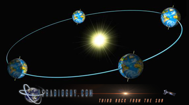
The Earth has seasons because of its axial tilt and its orbit around the sun. The Earth’s axis of rotation is tilted at an angle of 23.5 degrees relative to its orbital plane. As the Earth revolves around the sun, different parts of the planet receive varying amounts of solar radiation at different times of the year. When the northern hemisphere is tilted towards the sun, it receives more direct sunlight and experiences longer periods of daylight, resulting in warmer temperatures and the onset of summer. Conversely, when the northern hemisphere is tilted away from the sun, it receives less direct sunlight and experiences shorter periods of daylight, resulting in colder temperatures and the onset of winter.

Graphic by Dr. James O’Donoghue

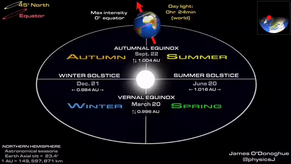
The Earth’s axial tilt also plays a role in the equinoxes, which mark the beginning of spring and fall. During the equinoxes, the tilt of the Earth’s axis is perpendicular to the sun’s rays, resulting in equal periods of daylight and darkness at all points on the planet. As the Earth continues to orbit the sun, the axial tilt gradually changes, leading to the onset of the different seasons. Without this axial tilt, the Earth would not experience any seasons, and the climate would be more uniform across the planet.

Spring:

Spring marks the beginning of the astronomical year when the Earth is positioned in such a way that the sun’s rays are directly hitting the equator. This results in an equal distribution of daylight and darkness, a phenomenon known as the vernal equinox. From the perspective of the GOES-16 satellite, the transition from winter to spring is characterized by a gradual increase in the amount of green vegetation on the ground, as dormant plants begin to sprout new leaves and buds. The satellite can also detect changes in atmospheric circulation patterns, as cold air masses retreat northward and warm air masses move in from the south.

Summer:

Summer is the season of longest days and shortest nights, as the Earth’s axis tilts towards the sun, and the northern hemisphere receives more direct sunlight. The resulting increase in solar radiation triggers a wide range of climatic and biological processes, from thunderstorms and hurricanes to blooming flowers and migrating birds. From the perspective of the GOES-16 satellite, the summer season is characterized by intense heating of the Earth’s surface, which leads to the formation of cumulus clouds and thunderstorms. The satellite can also monitor the movement of tropical storms and hurricanes, which often develop over warm ocean waters during the summer months.

Fall:

Fall, or autumn, is marked by the opposite astronomical phenomenon as spring – the autumnal equinox – when the Earth’s axis is again tilted away from the sun, resulting in shorter days and longer nights. This change triggers a cascade of biological processes, as plants prepare for the winter months by shedding leaves, fruits, and seeds. From the perspective of the GOES-16 satellite, the fall season is characterized by a gradual decrease in the amount of green vegetation, as trees and shrubs enter a period of dormancy. The satellite can also detect changes in atmospheric circulation patterns, as cold air masses from the north begin to move southward.

Winter:

Winter is the season of shortest days and longest nights, as the Earth’s axis is tilted furthest away from the sun, resulting in the least amount of direct sunlight. This leads to a period of dormancy for many plants and animals, as they conserve energy and wait for the return of spring. From the perspective of the GOES-16 satellite, the winter season is characterized by the formation of large-scale weather patterns, such as cold fronts, blizzards, and polar vortexes. The satellite can also monitor the movement of ice and snow cover on the ground, which plays an important role in regulating the Earth’s climate.

The four seasons – spring, summer, fall, and winter – are an integral part of the natural cycle of the Earth’s orbit around the sun. From the perspective of the GOES-16 satellite, these seasons are characterized by a wide range of astronomical and climatic phenomena, which affect the behavior of the Earth’s atmosphere, oceans, and biosphere. By studying these seasonal changes from space, we can gain a deeper understanding of the dynamics of our planet, and the impact of human activities on its delicate balance.

Special note to those in the Southern Hemisphere.

When Spring is starting in the Northern Hemisphere, Autumn is starting in the Southern Hemisphere. So in order to accurately reflect this fact please turn your computer or smartphone upside down and read this article backwards. Just kidding!!

Tags: Equinox post processing Satellite Imagery

Post navigation

❮ Previous Post: Mixed results for NOAA Funding
Next Post: Simon’s World Map ❯

You may also like

Hardware
The new CCOR instrument aboard GOES-U
July 7, 2024
Satellites
GOES-T Roll Out and Fueling
February 28, 2022
Satellites
GOES-U now GOES-19
July 8, 2024
Satellites
GOES-T Encapsulated inside payload fairings
February 11, 2022

Please, Help Support USRadioguy.com

If you like what I do please support me on Ko-fi, It really means a lot, every bit helps!

Hardware Humor Imagery Processing Interesting stuff you should know! Launch News Life News Product Review Satellites Science Software Space Weather Uncategorized VLOG

Alphabetical Listing of all Pages on site:

  • 36-Hour Imagery Processing script
  • 3D animation of realtime data
  • A PORTABLE WWII ERA “MORALE RADIO”
  • About Me
  • ADS-B Reception
  • Allsky Camera
  • AN/GRR-5 THE ANGRY 5
  • BD-71 Field Switch Board and EE-8B Field Telephones
  • Current GOES 16 & 18 False Color Satellite Imagery
  • Custom Color Lookup Table
  • Custom Imagery Scripts for GOES
  • Daily 3D view of Earth
  • Daily Global Composites
  • Decoding EWS-G1 or GOES-13
  • Drifting a geostationary satellite
  • DRONE FUN
  • Even the kitchen sink
  • GEO-RING COMPOSITES
  • GEO-SAT PI FRAME
  • Geo-stationary Satellite Imagery Reception
  • Global Weather Data
  • GOES 19&18 – Last 96 Hours of Imagery
  • GOES BAND IMAGERY
  • GOES GRB Reception
  • GOES receiving in Windows for SatDump
  • GOES-18 Preparing for a new satellite
  • GOES-R Series Multimedia Tour
  • GOES-U (19) Countdown to Launch
  • GOES16 A full year of received imagery
  • Ground Station Map
  • High Resolution Imagery
  • Home
  • House History
  • HRIT/EMWIN & GRB
  • HRPT Satellite Tracking and Capture
  • Hubble Space Telescope Data Processing
  • Inmarsat Decoding
  • Layering Fire and Hotspot Data on Meteor Sat Imagery
  • Layering Geo-Spatial Fire Data into Satellite Imagery
  • Mesoscale Imagery Defined
  • METEOR M2- Series
  • MODIS VIIRS Global Coverage
  • My Other Interests
  • NASA, NOAA, Military, GOVT dish, and tower stations.
  • National Hurricane Data
  • Newsletter terms & conditions
  • NOAA & Meteor APT and LRPT RECEPTION
  • Online Satellite Imagery and Information
  • Optimizing a WIFI Grid Antenna for Maximum Efficiency
  • ORBITAL DYNAMICS 101
  • Orbitron, Gpredict, and PSTRotator with new TLE format
  • PI Based Broadcastify Server
  • Pi Based Picture Frame
  • Presentations
  • Privacy Policy
  • Programming the PI for goestools operation
  • R-100/URR 1944 MORALE RADIO
  • RADIO SET SCR-284
  • Rare Captures
  • Receiving GOES 18,19 with goestools
  • Receiving GOES HRIT with SATDUMP
  • Receiving the Funcube Amateur Satellite
  • Satdump for Meteor and NOAA decoding
  • Satellite Finder
  • Satellite Frequencies
  • Satellite Ground Stations
  • Satellite Tracking
  • Security
  • SETEC Astronomy
  • Solar Power for PI
  • South America GOES 16
  • Space Weather
  • Stray Light Zone (SLZ)
  • Thanks!
  • The quest for True Color Imagery
  • Tried and Tested Hardware
  • Usradioguy Blogs
  • Usradioguy Merchandise
  • USRadioguy Newsletter
  • USRadioguy VLOGS
  • USRADIOGUY Youtube Page
  • VIBRATOR CONVERSION MODULE
  • Viterbi, R/S Errors, Packets
  • VS-3 VIBRATOR CONVERSION
  • What is RTL-SDR?
  • WWII Audio Page
  • WWII K-24 Aerial Camera
  • WWII RADIO
  • WxtoImg Fix
  • Zombie Satellites

Hardware Humor Imagery Processing Interesting stuff you should know! Launch News Life News Product Review Satellites Science Software Space Weather Uncategorized VLOG

Satellite And Weather Related Feeds

  • CIMSS Satellite Blog
  • USRadioguy.com
  • wildfires
  • NASA Earth Observatory
  • SPC Particularly Dangerous Situation (PDS) Tornado/Severe Thunderstorm Watch
  • satellites
  • Satellites News -- ScienceDaily
  • Satellite Liaison Blog
Wildfire in Ontario produces a large pyrocumulonimbus cloud
American Samoa’s Wettest Year Gets Wetter
Deadly flash flooding in Ruidoso, New Mexico
Global cloud layers on your Devices
End Of Life for NOAA 15 and 19?….not so fast…
Vitality GOES
Vitality GOES
The fire cycle
Unmasking the complicated chemistry of wildfire smoke: What's in it?
NOAA unveils powerful convergence of AI and science with revolutionary Next-Generation Fire System technology
The Salty Lake of Gas Hure
Greenland’s Bejeweled Ice Sheet
Manitoba Burning
Manitoba Burning
SPC PDS Severe Thunderstorm Watch 399
Five historically huge solar events
65 years since the world’s first weather satellite
Investing in America: NOAA's Science, Service and Stewardship in Action
Earth’s weather satellites just spent 10 years watching Venus — here’s what they found
Record-breaking 10-billion-year radio halo just rewrote the universe’s origin story
Massive thread of hot gas found linking galaxies — and it’s 10 times the mass of the Milky Way
The Need for Speed: OCTANE Cloud-Top Winds at SPC
Summer Storms, Flooding Target Mid-Atlantic
Southwest Thunderstorms – Late June 2025
  • Facebook Geo Stationary Satellites
  • Usradioguy Facebook
  • Instagram
  • Reddit
  • Github
  • Linkedin

Copyright © 2025 USRadioguy.com - All Rights Reserved. All material protected by Fair Use Section 107 of the Copyright Act. This site is Verified and Secured with 256 bit SSL encryption