![]()
Unveiling the Future of Earth Observation: NOAA’s GeoXO Mission
Get ready for a game-changer in Earth observation! The National Oceanic and Atmospheric Administration (NOAA) is gearing up for the Geostationary Extended Observations (GeoXO) mission, a next-generation constellation of satellites that will revolutionize our understanding of our planet. NOAA expects that GeoXO will begin operating in the early 2030s as the GOES-R Series nears the end of its operational lifetime.
Envisioning the Future
Imagine peering into the future, not with a crystal ball, but with cutting-edge satellites. That’s exactly what NOAA, along with a team of dedicated data users and industry partners, did to craft the observation priorities for the Geostationary Extended Observations (GeoXO) mission.
It wasn’t just about throwing technology at the sky. This was a meticulous, collaborative effort to ensure GeoXO captured the data that mattered most. Here’s how they did it:
- Gazing into the crystal ball: They started by envisioning future environmental scenarios. What challenges might we face? What data would be crucial to tackle them? This futuristic foresight laid the groundwork for GeoXO’s capabilities.
- Unleashing GeoXO’s potential: They then delved deep into the satellite’s technical prowess. What observations could it realistically make? Understanding its strengths and limitations guided our prioritization decisions.
- Weighing the benefits: Not all data is created equal. NOAA meticulously assessed the societal and economic impact of various observations. Would they improve weather forecasting, safeguard public health, or unlock scientific breakthroughs? Every bit of data had to earn its place on the priority list.
- Open ears, open minds: They didn’t stop there. NOAA reached out to the end user communities that would benefit most. Interviews, surveys, and workshops provided invaluable insights from farmers to firefighters, scientists to city planners. Yes, even the satellite enthusiasts were polled and surveyed! Their voices shaped the final observation lineup.
Through this rigorous process, they ensured that GeoXO wouldn’t just collect data, it would collect the right data. The data that empowers us to predict storms with pinpoint accuracy, protect our air and water resources, and ultimately, build a more resilient future for our planet.
So, the next time you hear about GeoXO, remember this: it’s not just a satellite, it’s the culmination of a collective vision for a healthier, safer Earth. And that vision was born from collaboration, foresight, and a deep understanding of our planet’s needs.
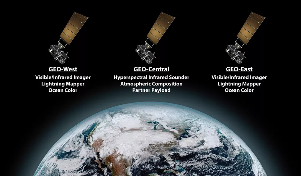
A Three-Satellite Powerhouse:
After careful evaluation, NOAA has chosen a three-satellite constellation design for GeoXO. This powerful trio will be strategically positioned in geostationary orbit, providing continuous monitoring of the Western Hemisphere.
- East and West sentinels: Two satellites will flank the region, each equipped with an imager, lightning mapper, and ocean color instrument. These instruments will capture real-time, high-resolution images of Earth’s surface, track the fury of lightning strikes, and unveil the secrets of our oceans’ color and health.
- Centralized powerhouse: At the heart of the constellation lies the third satellite. This powerhouse will carry a sounder and atmospheric composition instrument, peering deep into the atmosphere to measure temperature, humidity, and the makeup of the air we breathe.
Collaboration is Key:
The GeoXO mission is a testament to the power of collaboration. NASA is playing a crucial role, managing the development and launch of the satellites. Additionally, commercial partners will be brought on board to design and build the spacecraft and instruments.
Countdown to Launch:
The development of GeoXO is in full swing! In July 2022, NASA awarded contracts for Phase A studies of the spacecraft, paving the way for the next crucial step. Proposals for the spacecraft development contract were submitted in September 2023, and the contractor is expected to be chosen by May 2024.
Unveiling the Instruments:
NOAA has identified a suite of cutting-edge instruments for GeoXO, each tailored to specific environmental monitoring needs. Phase A studies are underway for each instrument, helping to refine their design, mature crucial technologies, and determine their performance, cost, and development timeline.
The Future is Bright:
GeoXO is not just a constellation of satellites; it’s a leap forward in our ability to understand and protect our planet. The data it gathers will be invaluable for:
- Improving weather forecasting and severe weather warnings
- Monitoring air quality and tracking the impact of pollution
- Studying climate change and its effects on our oceans and atmosphere
- Supporting a wide range of scientific research and applications
With its innovative design, collaborative spirit, and powerful instruments, GeoXO promises to be a game-changer in Earth observation. Stay tuned as this groundbreaking mission unfolds, and prepare to witness the future of our planet revealed in stunning detail!
Remember, the GeoXO instrument array is still subject to final program approval. But one thing is certain: the future of Earth observation is looking brighter than ever.
The GEO XO Timeline
The first GeoXO launch is slated for 2032, marking the dawn of a new era in Earth observation. But the mission’s reach extends far beyond that initial launch. GeoXO will maintain and advance NOAA’s geostationary observations through 2055, ensuring a continuous flow of critical data for generations to come.

The Selected Contractors to Date:
L3Harris Takes the Lead in Imaging Earth’s Future: Building the GeoXO Imager
Eyes on the Prize: NOAA’s Geostationary Extended Observations (GeoXO) mission promises a revolutionary leap in understanding our planet. And at the heart of this endeavor lies the GeoXO Imager (GXI), a powerful instrument ready to unveil Earth’s secrets in stunning detail.
L3Harris Technologies has been chosen by NASA, on behalf of NOAA, to develop this next-generation imager. This $765.5 million contract marks a significant milestone in the GeoXO journey.
Beyond a Contract, a Partnership: The collaboration extends beyond mere financial terms. The development will involve a three-way tango between L3Harris facilities, NASA’s Goddard Space Flight Center, and Kennedy Space Center. This combined expertise promises to push the boundaries of Earth observation technology.
GXI: Unveiling Earth’s Symphony:
Imagine an instrument that can:
- Capture real-time, high-resolution images of the Western Hemisphere in both visible and infrared light.
- Track the dance of clouds, revealing storm formation and atmospheric motion.
- Monitor vital signs like land surface temperature, fire, smoke, and even the health of vegetation.
- Become a guardian angel against hurricanes, aviation hazards, and natural disasters.
This is the magic of GXI. It’s not just a camera; it’s a multi-channel, passive imaging radiometer, a scientific marvel designed to paint a vibrant picture of our planet’s health and dynamics.
From Blueprint to Reality:
The contract encompasses the entire life cycle of GXI, from its initial design and meticulous analysis to fabrication, integration, and rigorous testing. L3Harris will then ensure its smooth launch and provide vital support throughout its 15-year on-orbit mission.
A Brighter Future, Pixel by Pixel:
The GeoXO Imager represents a giant leap forward in our ability to understand and protect our planet. With L3Harris at the helm, GXI is poised to become a cornerstone of the mission, providing invaluable data for weather forecasting, disaster preparedness, and scientific research.
So, the next time you gaze at the clouds, remember that beneath their swirling beauty lies a silent symphony of environmental forces. And thanks to L3Harris and the GeoXO Imager, we’ll soon have a front-row seat to this captivating performance, unlocking a future where we live in harmony with our ever-changing Earth.
Visuals to Enhance the Content:
- Featured Image: A captivating image of Earth captured from space, highlighting the diversity of its landscapes.
- L3Harris Logo: Showcase L3Harris’ logo to emphasize their role in the project.
- GeoXO Imager Illustration: A stylized illustration of the GeoXO Imager showcasing its multi-channel capabilities.
- Earth Observation Data Visualization: A data visualization depicting the various types of environmental data GXI will collect.
Ball Aerospace Tunes into Earth’s Whispers: Building the GeoXO Sounder
NOAA’s Geostationary Extended Observations (GeoXO) mission promises to revolutionize our understanding of Earth’s atmosphere. And at its core lies the GeoXO Sounder (GXS), a powerful instrument poised to listen to the planet’s faintest whispers – its temperature, moisture, and wind whispers.
Ball Aerospace Selected: In a pivotal step, NASA, on behalf of NOAA, has entrusted Ball Aerospace & Technologies Corporation with the development of this groundbreaking sounder. This $486.9 million contract marks a crucial victory in the GeoXO symphony.
Beyond a Contract, a Collaboration: Similar to the GeoXO Imager, the sounder’s development will be a collaborative effort. Ball Aerospace’s expertise will blend seamlessly with the resources of NASA’s Goddard Space Flight Center and Kennedy Space Center, ensuring every note of GXS is perfectly orchestrated.
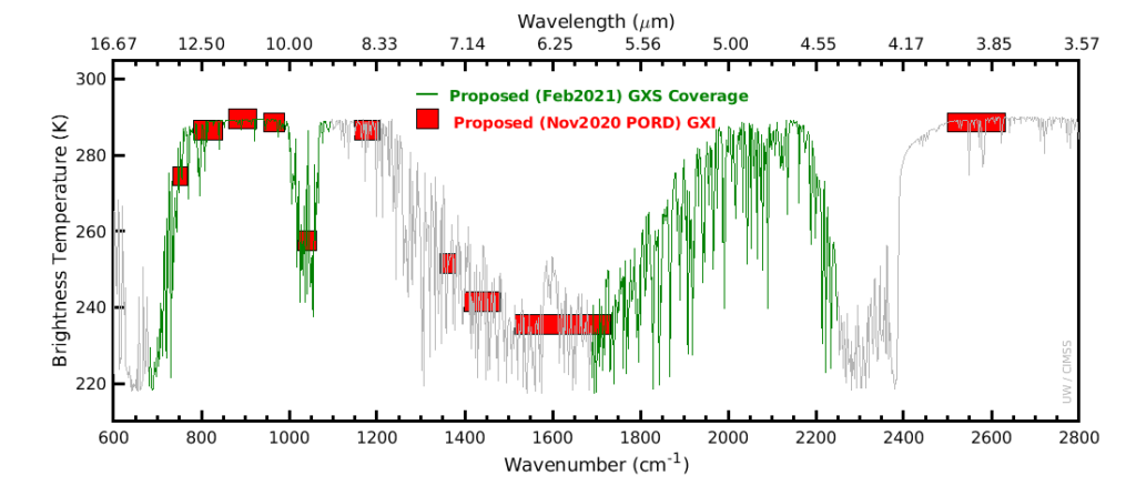
GXS: Decoding Earth’s Atmospheric Song:
Imagine an instrument that can:
- Listen to the infrared symphony of our atmosphere, revealing the vertical distribution of moisture, temperature, and winds.
- Provide real-time data on a vast scale, covering the entire Western Hemisphere.
- Empower forecasters to predict not just weather, but the birth and fury of severe storms and hurricanes.
- Become a silent guardian, safeguarding lives and property from nature’s wrath.
This is the magic of GXS. It’s not just a fancy thermometer; it’s a hyperspectral infrared instrument, a technological marvel that translates the whispers of infrared light into actionable insights for a safer, healthier planet.
From Blueprint to Harmony:
The contract encompasses GXS’ entire journey, from its initial design and meticulous tuning to fabrication, integration, and rigorous testing. Ball Aerospace will then ensure its smooth launch and provide vital support throughout its 15-year on-orbit mission.
A Symphony of Knowledge, Note by Note:
The GeoXO Sounder represents a harmonious blend of human ingenuity and technological prowess. With Ball Aerospace at the helm, GXS is poised to become a key instrument in the mission, providing invaluable data for weather forecasting, disaster preparedness, and scientific research.
So, the next time you feel the wind brush against your cheek, remember that it’s part of a grand atmospheric symphony. And thanks to Ball Aerospace and the GeoXO Sounder, we’ll soon be able to decipher its melodies and rhythms, paving the way for a future where we live in tune with our dynamic planet.
Visuals to Enhance the Content:
- Featured Image: An artistic representation of the Earth’s atmosphere with swirling bands of color representing temperature, moisture, and wind.
- Ball Aerospace Logo: Showcase Ball Aerospace’s logo to emphasize their role in the project.
- GeoXO Sounder Illustration: A stylized illustration of the GeoXO Sounder highlighting its hyperspectral capabilities.
- Atmospheric Data Visualization: A data visualization depicting the various types of atmospheric data GXS will collect.