Skip to content
USRADIOGUY

USRadioguy.com

Welcome to USRadioguy.com – Unlocking the Potential of Software Defined Radio

  • Home
    • Home of USRadioguy
    • Tried and Tested Hardware
    • USRadioguy Newsletter
    • What is RTL-SDR?
    • Global Weather Data
  • Satellite Reception
    • Geo Stationary Satellites
      • Geo-stationary Satellite Imagery Reception
      • GOESTOOLS on the PI
      • Update Goestools for GOES 18,19
      • Receiving GOES with SatDump CLI Mode
      • GOES receiving in Windows for SatDump GUI
      • Decoding EWS-G1/EWS-G2
      • GOES GRB Reception WIP
      • Optimizing a WIFI Grid Antenna for Maximum Efficiency
    • APT Satellites
      • APT RECEPTION
      • Satdump for Meteor and NOAA decoding
      • METEOR M2- Series
      • WxtoImg Fix
      • Converting to new TLE format
      • Layering Fire and Hotspot Data on Meteor Sat Imagery
      • HRPT Satellite Tracking and Capture
    • Receiving Other Satellites
      • Inmarsat Decoding
      • Receiving the Funcube Amateur Satellite
    • User Maps and Dish Pointers
      • Satellite Dish Pointer
      • User Global Ground Station Maps
      • Usermap rendered with Cesium
      • Global Map of Govt Dish Stations
    • Satellite Details & Information
      • ORBITAL DYNAMICS 101
      • HRIT/EMWIN & GRB Defined
      • Mesoscale Imagery Defined
      • Viterbi, R/S Errors, Packets
      • GOES BAND IMAGERY
      • Stray Light Zone (SLZ)
      • Drifting a geostationary satellite
      • GOES-R Series Multimedia Tour
      • Online Satellite Imagery and Information
      • Satellite Frequencies
      • Solar and Space Weather
  • Satellite Imagery
    • IMAGERY- Current GOES East & West HRIT Satellite Imagery
    • IMAGERY- GOES 16&18 – Past 96 Hours of Imagery
    • High Resolution Imagery
    • Daily 3D view of Earth
    • PlanetMaker
    • GOES16 A full year of received imagery
  • Imagery Processing
    • Custom Color Lookup Table & Gradients
    • GOES-R Custom Imagery Scripts
    • Global geo-ring composites
    • MODIS VIIRS Global Coverage
    • 3D Satellite Tracking
    • The quest for True Color Imagery
    • 3D animation of realtime data
    • Layering Geo-Spatial Fire Data into Satellite Imagery
    • Orbital dynamics and the Moon
    • National Hurricane Data
  • News, VLOGS & BLOGS
    • News & USRadioguy Blogs
    • USRadioguy VLOGS
  • Project Lab
    • Orbital Information and Visualizations
      • Enhanced Planet Earth
      • Satellites in Orbit
      • Solar System
      • Objects in Orbit
    • Current Station Weather
      • Current Groundstation Weather
      • Global Weather Data
      • Space Weather
    • WWII RADIO
      • WWII K-24 Aerial Camera
      • WWII RADIO
      • RADIO SET SCR-284
      • VS-3 VIBRATOR CONVERSION
      • VIBRATOR CONVERSION MODULE
      • BD-71 Field Switch Board and EE-8B Field Telephones
      • R-100/URR 1944 MORALE RADIO
      • A PORTABLE WWII ERA “MORALE RADIO”
      • AN/GRR-5 THE ANGRY 5
      • WWII Audio Page
    • Raspberry Pi Projects
      • ADS-B Reception
      • Allsky Camera
      • Pi Based Picture Frame
      • PI Based Broadcastify Server
      • Solar Power for PI
    • Your very Own Weather Satellite
    • Hubble Space Telescope Data Processing
    • Zombie Satellites
    • DRONES
  • About Me
    • About Usradioguy
      • SETEC Astronomy
    • Tried and Tested Hardware
    • Rare Captures
    • My Other Interests
    • Presentations
    • Merchandise
    • Privacy Policy
  • Home
  • Satellites
  • NOAA 15 and 19 Decommisioning

NOAA 15 and 19 Decommisioning

Posted on August 1, 2025August 13, 2025 By Carl 4 Comments on NOAA 15 and 19 Decommisioning
News, Satellites

Loading


UPDATE August 13 2025

NOAA 19 was decommissioned early as a result of a battery failure that occurred on August 9, 2025. This battery failure jeopardizes the ability to ensure safe operations of the spacecraft. Based on NOAA’s requirement to responsibly manage on-orbit assets, NOAA-19 was passivated on August 13, 2025 Rev 85130 at 1655 UTC. This decommission was performed less than 1 week from when the planned decommission was scheduled to take place. NOAA-15 planned decommission has been delayed to next week.

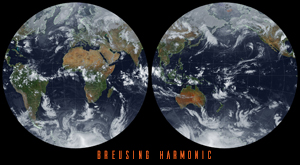
NOAA-19 is a legacy Polar Operational Environmental Satellites (POES) satellite and is operated with no performance or latency requirements. Users should transition to NOAA’s Joint Polar Satellite System (JPSS). JPSS provides global observations that serve as the backbone of both short- and long-term forecasts, including those that help us predict and prepare for severe weather events. The five satellites scheduled in the fleet are the currently-flying NOAA/NASA Suomi National Polar-orbiting Partnership (Suomi NPP) satellite, NOAA-20, previously known as JPSS-1, NOAA-21, previously known as JPSS-2, and the upcoming JPSS-3 and JPSS-4 satellites.

UPDATE August 12, 2025 Due to an unexpected anomaly with the NOAA-19 satellite, the planned decommissioning of the NOAA-15 satellite has been postponed. The new timeframe for NOAA-15’s decommissioning is now scheduled for the week of August 18th, though the precise date within that week has not yet been determined.

UPDATE August 11, 2025 – This is the final reminder that NOAA-15 is scheduled to be decommissioned on August 12, 2025 from 1506 to 1520 UTC. NOAA-19 will follow one week later on August 19, 2025.

End of an Era: Decommissioning the Legacy POES Satellites

The National Oceanic and Atmospheric Administration (NOAA) has officially wrapped up End-of-Life (EOL) testing for NOAA-15 and NOAA-19, signaling the imminent decommissioning of these two venerable spacecraft. As the last operational platforms in the enduring NOAA Polar Operational Environmental Satellites (POES) constellation, their retirement marks a significant transition.

Both satellites have far outlived their initial design lives, a testament to their robust engineering, but also a factor in their current state. They’ve experienced considerable degradation and outright failures across various critical subsystems and scientific instruments. These issues have pushed them into a “twilight phase,” where the likelihood of catastrophic failure modes is increasingly high.

It’s worth remembering that NOAA-18 was already decommissioned on June 6, 2025, at 17:40 UTC. That decision came after an unrecoverable anomaly with its S-Band transmitter, which completely halted its ability to send vital telemetry and mission data back to Earth.

The final decommissioning schedule for the remaining POES constellation assets is as follows:

NOAA-19: August 19, 2025

NOAA-15: August 12, 2025

Decommisioned

A Legacy’s Sunset: The History and Decommissioning of NOAA-15, -18, and -19

END OF AN ERA

The National Oceanic and Atmospheric Administration’s (NOAA) Polar Operational Environmental Satellites (POES) constellation has served as a cornerstone of global weather forecasting and environmental monitoring for decades. As technology advances and the operational lifespan of these venerable spacecraft comes to a close, NOAA is progressively decommissioning the final members of this series. This marks a significant transition in NOAA’s satellite operations, as newer, more advanced systems like the Joint Polar Satellite System (JPSS) assume primary roles.

Here’s a look at the history and decommissioning of NOAA-15, -18, and -19:
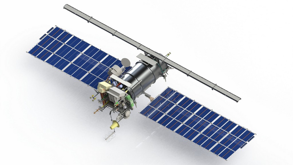
NOAA-15 (NOAA-K)

  • Launch Date: May 13, 1998
  • Mission: NOAA-15 was the first of the fifth generation of POES satellites, designed to provide critical data for weather forecasting, climate research, and search and rescue operations. It carried instruments such as the Advanced Microwave Sounding Unit (AMSU), Advanced Very High Resolution Radiometer (AVHRR/3), and High-resolution Infrared Radiation Sounder (HIRS/3), alongside a Search and Rescue Satellite-Aided Tracking (SARSAT) system. NOAA-15 was crucial for its morning orbit coverage, complementing the afternoon orbits of other POES satellites.
  • Decommissioning: After an impressive 27 years in orbit, far exceeding its design life, NOAA-15 is scheduled to be decommissioned on August 12, 2025. It has experienced significant subsystem and instrument degradation, reaching a point where its continued operational use is no longer viable for critical applications.

NOAA-18 (NOAA-N)

  • Launch Date: May 20, 2005
  • Mission: NOAA-18 further enhanced the POES constellation with improved instruments, including an upgraded HIRS (HIRS/4) and the Microwave Humidity Sounder (MHS), in addition to AMSU-A, AVHRR/3, and SARSAT. It operated in an afternoon orbit, providing vital data for global weather models and contributing to a wide range of environmental monitoring applications. For nearly 20 years, it collected global weather information, ensuring that every point on Earth was observed at least every 12 hours.
  • Decommissioning: NOAA-18 was decommissioned earlier this year, on June 6, 2025, at 17:40 UTC. The decision was prompted by an unrecoverable failure of its S-Band transmitter, which was essential for both commanding the satellite and downlinking its global science data. This failure compromised the satellite’s ability to operate safely and effectively.

NOAA-19 (NOAA-N Prime)

  • Launch Date: February 6, 2009
  • Mission: NOAA-19 was the final satellite in the POES series and incorporated further instrument enhancements, including a fully integrated Advanced Data Collection System (A-DCS). Like NOAA-18, it occupied an afternoon orbit, contributing significantly to atmospheric temperature and humidity soundings, sea surface temperature measurements, and search and rescue support.
  • Decommissioning: NOAA-19, the last operational satellite of the legacy POES constellation, is slated for decommissioning on August 19, 2025. Despite having provided over 16 years of valuable data, it has entered its “twilight phase” with increasing likelihood of critical failures across its aging subsystems and instruments.

The decommissioning of these satellites marks the end of a remarkable era for NOAA’s polar-orbiting capabilities. While their direct operational use will cease, NOAA continues to responsibly manage these orbital assets to mitigate space debris and ensure the long-term sustainability of space operations. The baton has now largely passed to the more technologically advanced JPSS constellation, which will continue NOAA’s vital mission of Earth observation from polar orbit.

Tags: Satellite Satellite Imagery

Post navigation

❮ Previous Post: Discovery Drive
Next Post: WXtoIMG: A Legacy in Weather Satellite Decoding ❯

You may also like

Satellites
Online Dish Pointer
January 22, 2023
Satellites
GOES-18 HRIT- First Light Imagery
June 15, 2022
Hardware
NOAA Requests proposals to limit 5G (6G) interference.
April 15, 2023
The Seasons
Imagery Processing
The Seasons
March 19, 2024

4 thoughts on “NOAA 15 and 19 Decommisioning”

  1. Carl says:
    August 1, 2025 at 9:11 am

    Farewell to Faithful Watchers: Saying Goodbye to NOAA-15, -18, and -19
    It’s truly the end of an era for Earth observation as we prepare to say goodbye to three long-serving sentinels: NOAA-15, NOAA-18, and NOAA-19. These polar-orbiting satellites have collectively provided decades of invaluable data, shaping our understanding of weather patterns, climate change, and environmental conditions.
    They’ve tracked hurricanes, monitored sea ice, assisted in search and rescue operations, and contributed to countless weather forecasts we rely on daily here in the US, and across the globe.

    While technology marches on and new, advanced satellites like the JPSS series take the reins, we can’t help but feel a sense of gratitude and nostalgia for these steadfast spacecraft. They represent a remarkable commitment to understanding and protecting our planet.

    Thank you, NOAA-15, NOAA-18, and NOAA-19, for your years of dedicated service. Your legacy will continue to inform our future.

  2. Scott Harvey says:
    August 2, 2025 at 5:44 pm

    Why can’t you just leave these operational until they die. Leave them active for us amateur APT weather enthusiasts? It doesn’t cost to just let them run.

    1. Carl says:
      August 3, 2025 at 6:57 am

      Well, not quite accurate, first they want to avoid what happened to NOAA 16 and 17, which resulted in the satellites exploding and generating thousands of pieces of orbital debris. Which is why all sats now are on a program to render them as inert as possible before that happens. And, it does cost quite a bit of money for command and control to run the satellites to keep them in the proper attitude, altitudes, positioning etc.

  3. Pingback: NOAA 15 and 19 To Be Decommissioned Within the Next Two Weeks

Comments are closed.

Please, Help Support USRadioguy.com

If you like what I do please support me on Ko-fi, It really means a lot, every bit helps!

Hardware Humor Imagery Processing Interesting stuff you should know! Launch News Life News Product Review Satellites Science Software Space Weather Uncategorized VLOG

Alphabetical Listing of all Pages on site:

  • 36-Hour Imagery Processing script
  • 3D animation of realtime data
  • A PORTABLE WWII ERA “MORALE RADIO”
  • About Me
  • ADS-B Reception
  • Allsky Camera
  • AN/GRR-5 THE ANGRY 5
  • BD-71 Field Switch Board and EE-8B Field Telephones
  • Current GOES 16 & 18 False Color Satellite Imagery
  • Custom Color Lookup Table
  • Custom Imagery Scripts for GOES
  • Daily 3D view of Earth
  • Daily Global Composites
  • Decoding EWS-G1 or GOES-13
  • Drifting a geostationary satellite
  • DRONE FUN
  • Even the kitchen sink
  • GEO-RING COMPOSITES
  • GEO-SAT PI FRAME
  • Geo-stationary Satellite Imagery Reception
  • Global Weather Data
  • GOES 19&18 – Last 96 Hours of Imagery
  • GOES BAND IMAGERY
  • GOES GRB Reception
  • GOES receiving in Windows for SatDump
  • GOES-18 Preparing for a new satellite
  • GOES-R Series Multimedia Tour
  • GOES-U (19) Countdown to Launch
  • GOES16 A full year of received imagery
  • Ground Station Map
  • High Resolution Imagery
  • Home
  • House History
  • HRIT/EMWIN & GRB
  • HRPT Satellite Tracking and Capture
  • Hubble Space Telescope Data Processing
  • Inmarsat Decoding
  • Layering Fire and Hotspot Data on Meteor Sat Imagery
  • Layering Geo-Spatial Fire Data into Satellite Imagery
  • Mesoscale Imagery Defined
  • METEOR M2- Series
  • MODIS VIIRS Global Coverage
  • My Other Interests
  • NASA, NOAA, Military, GOVT dish, and tower stations.
  • National Hurricane Data
  • Newsletter terms & conditions
  • NOAA & Meteor APT and LRPT RECEPTION
  • Online Satellite Imagery and Information
  • Optimizing a WIFI Grid Antenna for Maximum Efficiency
  • ORBITAL DYNAMICS 101
  • Orbitron, Gpredict, and PSTRotator with new TLE format
  • PI Based Broadcastify Server
  • Pi Based Picture Frame
  • Presentations
  • Privacy Policy
  • Programming the PI for goestools operation
  • R-100/URR 1944 MORALE RADIO
  • RADIO SET SCR-284
  • Rare Captures
  • Receiving GOES 18,19 with goestools
  • Receiving GOES HRIT with SATDUMP
  • Receiving the Funcube Amateur Satellite
  • Satdump for Meteor and NOAA decoding
  • Satellite Finder
  • Satellite Frequencies
  • Satellite Ground Stations
  • Satellite Tracking
  • Security
  • SETEC Astronomy
  • Solar Power for PI
  • South America GOES 16
  • Space Weather
  • Stray Light Zone (SLZ)
  • Thanks!
  • The quest for True Color Imagery
  • Tried and Tested Hardware
  • Usradioguy Blogs
  • Usradioguy Merchandise
  • USRadioguy Newsletter
  • USRadioguy VLOGS
  • USRADIOGUY Youtube Page
  • VIBRATOR CONVERSION MODULE
  • Viterbi, R/S Errors, Packets
  • VS-3 VIBRATOR CONVERSION
  • What is RTL-SDR?
  • WWII Audio Page
  • WWII K-24 Aerial Camera
  • WWII RADIO
  • WxtoImg Fix
  • Your very Own Weather Satellite
  • Zombie Satellites

Hardware Humor Imagery Processing Interesting stuff you should know! Launch News Life News Product Review Satellites Science Software Space Weather Uncategorized VLOG

Satellite And Weather Related Feeds

  • CIMSS Satellite Blog
  • USRadioguy.com
  • wildfires
  • NASA Earth Observatory
  • SPC Particularly Dangerous Situation (PDS) Tornado/Severe Thunderstorm Watch
  • satellites
  • Satellites News -- ScienceDaily
  • Satellite Liaison Blog
Resuspended volcanic ash from the 1980 eruptions of Mount St. Helens
Outbreak of tornadoes across North Dakota
Post-Tropical Cyclone Kiko north of Hawai’i
SatDump 2.0
SatDump 2.0
WXtoIMG: A Legacy in Weather Satellite Decoding
NOAA 15 and 19 Decommisioning
The fire cycle
New NOAA tool can predict potential wildfires on an hourly basis
Unmasking the complicated chemistry of wildfire smoke: What's in it?
By the Warm Light of the Moon
Arctic Sea Ice Ties for 10th-Lowest on Record
Cooper Creek Replenishes Lake Eyre
SPC PDS Severe Thunderstorm Watch 399
Experts to preview launch of historic NOAA space weather satellite observatory
Five historically huge solar events
65 years since the world’s first weather satellite
Hubble just revealed the fiery heart of the Cigar Galaxy
This rare white dwarf looks normal, until Hubble shows its explosive secret
A weirdly shaped telescope could finally find Earth 2. 0
Hurricane Erin: East Coast Impacts and Extratropical Transition
Hurricane Erin (2025) Rapid Intensification
August 2025 Milwaukee Flooding
  • Facebook Geo Stationary Satellites
  • Usradioguy Facebook
  • Instagram
  • Reddit
  • Github
  • Linkedin

Copyright © 2025 USRadioguy.com - All Rights Reserved. All material protected by Fair Use Section 107 of the Copyright Act. This site is Verified and Secured with 256 bit SSL encryption

Help Fund USRadioguy.com

USRadioguy Needs Your Help