Skip to content
USRADIOGUY

USRadioguy.com

Welcome to USRadioguy.com – Unlocking the Potential of Software Defined Radio

  • Home
    • Home of USRadioguy
    • Tried and Tested Hardware
    • USRadioguy Newsletter
    • What is RTL-SDR?
    • Global Weather Data
  • Satellite Reception
    • Geo Stationary Satellites
      • Geo-stationary Satellite Imagery Reception
      • GOESTOOLS on the PI
      • Update Goestools for GOES 18,19
      • Receiving GOES with SatDump CLI Mode
      • GOES receiving in Windows for SatDump GUI
      • Decoding EWS-G1/EWS-G2
      • GOES GRB Reception WIP
      • Optimizing a WIFI Grid Antenna for Maximum Efficiency
    • APT Satellites
      • APT RECEPTION
      • Satdump for Meteor and NOAA decoding
      • METEOR M2- Series
      • WxtoImg Fix
      • Converting to new TLE format
      • Layering Fire and Hotspot Data on Meteor Sat Imagery
      • HRPT Satellite Tracking and Capture
    • Receiving Other Satellites
      • Inmarsat Decoding
      • Receiving the Funcube Amateur Satellite
    • User Maps and Dish Pointers
      • Satellite Dish Pointer
      • User Global Ground Station Maps
      • Usermap rendered with Cesium
      • Global Map of Govt Dish Stations
    • Satellite Details & Information
      • ORBITAL DYNAMICS 101
      • HRIT/EMWIN & GRB Defined
      • Mesoscale Imagery Defined
      • Viterbi, R/S Errors, Packets
      • GOES BAND IMAGERY
      • Stray Light Zone (SLZ)
      • Drifting a geostationary satellite
      • GOES-R Series Multimedia Tour
      • Online Satellite Imagery and Information
      • Satellite Frequencies
      • Solar and Space Weather
  • Satellite Imagery
    • IMAGERY- Current GOES East & West HRIT Satellite Imagery
    • IMAGERY- GOES 16&18 – Past 96 Hours of Imagery
    • High Resolution Imagery
    • Daily 3D view of Earth
    • PlanetMaker
    • GOES16 A full year of received imagery
  • Imagery Processing
    • Custom Color Lookup Table & Gradients
    • GOES-R Custom Imagery Scripts
    • Global geo-ring composites
    • MODIS VIIRS Global Coverage
    • 3D Satellite Tracking
    • The quest for True Color Imagery
    • 3D animation of realtime data
    • Layering Geo-Spatial Fire Data into Satellite Imagery
    • Orbital dynamics and the Moon
    • National Hurricane Data
  • News, VLOGS & BLOGS
    • News & USRadioguy Blogs
    • USRadioguy VLOGS
  • Project Lab
    • Orbital Information and Visualizations
      • Enhanced Planet Earth
      • Satellites in Orbit
      • Solar System
      • Objects in Orbit
    • Current Station Weather
      • Current Groundstation Weather
      • Global Weather Data
      • Space Weather
    • WWII RADIO
      • WWII K-24 Aerial Camera
      • WWII RADIO
      • RADIO SET SCR-284
      • VS-3 VIBRATOR CONVERSION
      • VIBRATOR CONVERSION MODULE
      • BD-71 Field Switch Board and EE-8B Field Telephones
      • R-100/URR 1944 MORALE RADIO
      • A PORTABLE WWII ERA “MORALE RADIO”
      • AN/GRR-5 THE ANGRY 5
      • WWII Audio Page
    • Raspberry Pi Projects
      • ADS-B Reception
      • Allsky Camera
      • Pi Based Picture Frame
      • PI Based Broadcastify Server
      • Solar Power for PI
    • Your very Own Weather Satellite
    • Hubble Space Telescope Data Processing
    • Zombie Satellites
    • DRONES
  • About Me
    • About Usradioguy
      • SETEC Astronomy
    • Tried and Tested Hardware
    • Rare Captures
    • My Other Interests
    • Presentations
    • Merchandise
    • Privacy Policy
  • Home
  • Satellites
  • Adios GOES-17

Adios GOES-17

Posted on December 30, 2022January 6, 2023 By Carl
Satellites

Loading

On the road again…

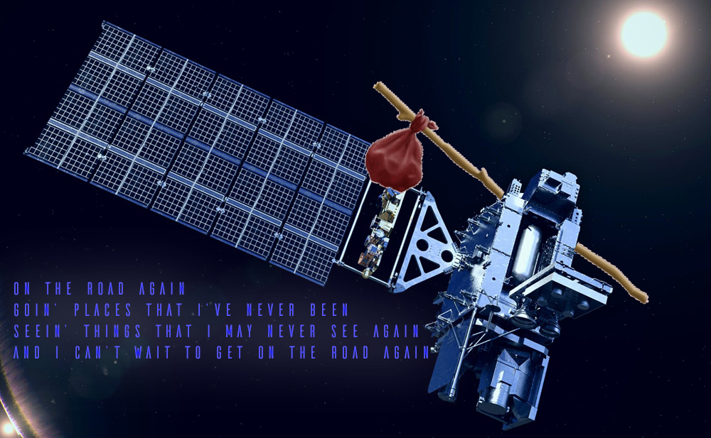
GOES-17, is soon to be headed off into the sunrise, that is, it will begin drifting to its new, on-orbit storage location east of its current 137.3°W to 104.7°W as GOES-18 Takes over on January 4th, 2023

NOAA will be drifting GOES-17 (NORAD 43226) Eastwards from 137.3°W to 104.7°W starting on January 10th, 2023, at a leisurely drift rate of 1.05°E per day, ending February 9th, 2023. Click to enlarge

On January 4th GOES-18 will step up and become the GOES-West geostationary satellite covering the Pacific and Western portions of North and South America. While I can’t say that GOES-18 was exactly “rushed” into service, it definitely was placed on the fast track to replace GOES-17 with its ailing heat pipe loop issues that caused serious degradation in certain bands imagery, resulting in a cooling timeline implementation schedule that prevented optimal analysis for proper meteorological uses.

You may be wondering, how exactly does a satellite physically get moved from point A to point B thousands of miles above Earth? NOAA’s operations team plans all of these maneuvers using navigation software. For a satellite to change its orbital position, it follows a series of commands uploaded by the operations team to the spacecraft’s memory. The mission operations center validates and rehearses these maneuver sequences on the ground using a satellite simulator.

How do you DRIFT a Satellite???
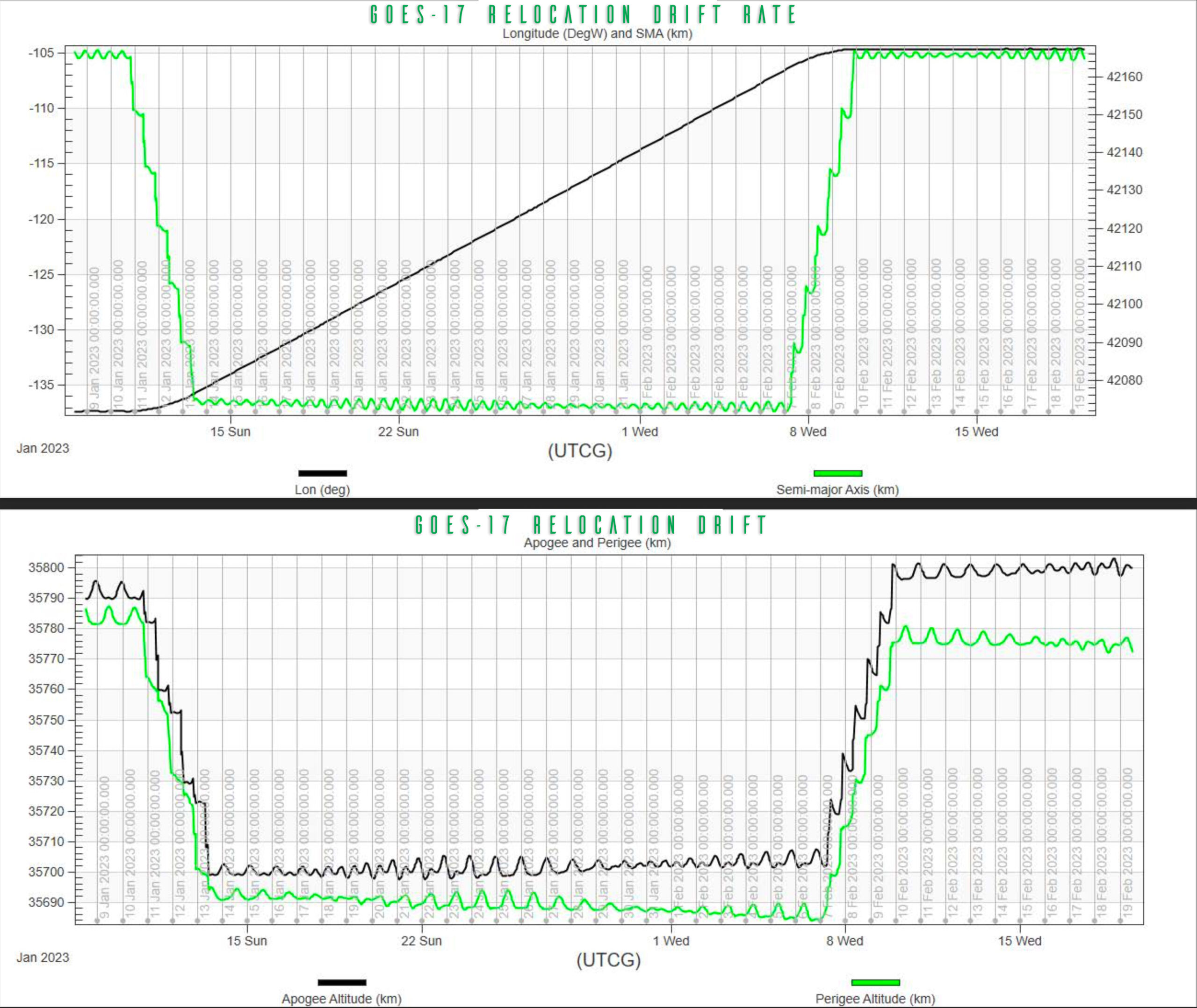
Let’s start with the basics. On January 10th, 2023 , GOES-17 will begin moving east. Normally, a geosynchronous satellite like GOES-17 remains in a fixed position in the sky relative to Earth’s rotation. This won’t be the case once the drift process gets underway. During its relocation, GOES-17’s five main instruments (ABI, GLM, SUVI, SEISS, and EXIS) will be turned off and placed in safe or diagnostic mode.

Normally, satellites maintain the same distance from Earth while operational (i.e. transmitting data). When it is required to initiate a orbit repositioning to a further east longitude orbit position, there is a need to advance the position gradually in easterly direction for a while, typically over a few weeks till the new position is reached. To accomplish this during the drift period, GOES-17’s altitude will actually be lowered slightly (by about 60 miles). This maneuver uses the resulting increase in gravity on GOES-17 to help nudge the satellite to begin moving into its new orbital position. This actually changes the geostationary orbit to a slightly eliptical orbit. Around February 8th, as GOES-17 gets close to its new orbital position, NOAA’s operations team raises the satellite back to its normal operating altitude, which will be on February 10th 2023. NOAA’s missions operations division uses this lowering and raising process any time its geosynchronous satellites need to change orbital positions.

The drift manuever must also take into account relevant harmonics of the gravity field at the altitude of geostationary orbits, as well as solar radiation pressure and third-body perturbations caused by the Moon and the Sun. All Geo-stationary Satellites also perform station keeping navigation. In a year, relative to the center of the Earth, a geosatellite travels 80 million km. A drift of only 0.01% would result in 8000 km of drift in a year, if allowed to go uncorrected.
Since the velocity is 2500 meters per second, an annual budget of 50 meters per second is 2% of the total velocity. This is corrected with GOES with small thrusters when needed.
If there is a need to move a satellite westwards, the above procedure is modified to raise it temporarily to a higher orbit, so it gradually goes backwards in longitude..

Geostationary orbit
Altitude = 35,786 km from equator
Speed = 11,052 km/hr
Period = 23 Hours, 56 Minutes

GOES-17 History

GOES-S (17) Launch on 3/1/2018

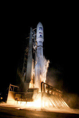
The satellite was launched into space on 1 March 2018 by an Atlas V (541) launch vehicle from Cape Canaveral Air Force Station, Florida. It had a launch mass of 5,192 kg (11,446 lb.] On 12 March 2019, GOES-17 joined GOES-16 (launched in 2016) in a geostationary orbit at 35,700 km (22,200 mi) above Earth.
On 24 October 2018, GOES-17 began a 20-day, 2.5°/day westward drift maneuver from its checkout position of 89.5° West longitude to its operational position of 137.2° West. During the drift maneuver, all instruments except for the magnetometer were disabled. Meanwhile, GOES-15 began an eastward drift maneuver on 29 October 2018 to 128° West, with all of its sensors still functioning. It reached its new location on 7 November 2018.

GOES-17 began transmitting its first images on 13 November 2018. The first high-definition images transmitted were of Alaska, Hawaii, and the Pacific Ocean.

GOES-15’s drift was intended to provide additional separation from GOES-17 to prevent communication interference. GOES-17 reached its assigned longitude on 13 November 2018 and began additional testing. GOES-17 was declared operational on 12 February 2019. Both GOES-17 and GOES-15 operated in tandem through early 2020 to allow assessment of GOES-17’s performance as GOES-West. On 2 March 2020, GOES-15 was deactivated and moved to a storage orbit at 105.0°W

GOES-17 Malfunctions

On 23 May 2018, NOAA announced that there were problems with the cooling system of the Advanced Baseline Imager. Due to the cooling failure, infrared and near-infrared imaging was only possible for 12 hours per day. The issue affects 13 of the infrared and near-infrared channels on the instrument. No other sensors of the satellite are affected.

During a media conference call on 24 July 2018, the problem component was identified as the loop heat pipe, which transports heat from the cryocooler and ABI to radiators. The degraded performance of this component means the ABI gets hotter than intended, which lowers the sensitivity of the infrared sensors. In order to work properly, the sensors need to be cooled to varying degrees depending on what wavelength they observe; the sensors operating in the longest wavelengths need to be kept as low as −212.8 °C (−351.0 °F; 60.3 K) in order to reduce thermal noise.

The orbit of the spacecraft brings the ABI into full sunlight more often around the equinoxes, resulting in more solar radiation being absorbed by the ABI and degrading the performance of the infrared channels, with projections indicating that 10 of the 16 channels would be available 24 hours a day, with the other six channels available for “most of the day, to varying degrees, depending on their wavelength.

Possible causes included debris or foreign objects inside the heat pipe, or an improper amount of propylene coolant. The final conclusion of the independent failure review team’s investigation, released on 3 October 2018, was that “the most likely cause of the thermal performance issue is foreign object debris (FOD) blocking the flow of the coolant in the loop heat pipes. A series of ground-based tests introducing FOD into test pipes supported FOD as the most likely cause.

Engineers mitigated the issue through operational changes to the ABI and mission operations, including the use of Artificial Intelligence techniques, to regain the capability to collect data during a portion of the affected period. Those efforts have resulted in the GOES-17 ABI delivering 98 percent of the expected data.

On 20 November 2018, a memory error occurred in the ABI which resulted from a software update for its cryocooler subsystem. This resulted in automated onboard safety checks shutting down the cryocooler. It was restored to operation on 25 November 2018, and engineers began working on a permanent software fix for deployment in January 2019

On 15 August 2019, GOES-17 experienced a brief “spacecraft anomaly” from about 13:45 to 17:00 UTC. This anomaly prevented the delivery of all bands and scenes.

The Massive Hunga Tonga Eruption as Captured by GOES-17
The Massive Hunga Tonga Eruption as Captured by GOES-17 in Band 13 IR

NOAA Will place GOES-17 into “on-orbit storage” at 104.7°W (Orbital Storage means any period of time of intentional non-use by the operator of the satellite that has been launched and is capable of performing in accordance with the minimum performance specifications.)

GOES-17 will remain in on-orbit storage until it is needed to replace GOES-16 or GOES-18 or even GOES-15.

Artist rendition of GOES-17 courtesy of Lockheed Martin

Next up – GOES-U

GOES-U is next up for launch

NOAA’s GOES-U, the final satellite in the GOES-R Series of advanced geostationary environmental satellites, recently completed thermal vacuum (TVAC) testing as part of a rigorous assessment program to ensure the satellite can withstand the harsh conditions of launch and orbiting 22,236 miles above Earth’s equator. The testing is taking place at Lockheed Martin Space’s Littleton, Colorado, facility, where GOES-U was built.

GOES-U, the final satellite in the GOES-R Series, is scheduled to launch in April 2024 from Cape Canaveral Space Force Station in Florida. The satellite will be renamed GOES-19 once it reaches geostationary orbit, approximately two weeks after launch.  At this time, GOES-19, once post-launch testing is completed, is scheduled to go into immediate On-orbit storage, and serve as a backup/ replacement to both GOES East and GOES-West. Should it be needed to complete the GOES-R mission into the 2030s when the GEO-XO program is set to replace GOES-R.

Why put GOES-19 into storage on orbit?

If GOES-U were stored on the Earth, it would have to be called out of deep storage to replace an on-orbit failure. There would be a minimum of 9 to 12 months of preparation between call-up and launch, followed by 3- 9 months of post-launch deployment and testing before it could become operational. On-orbit storage reduces this delay from one year to less than one week, or even a couple of days, and avoids the chance of a launch failure when NOAA can least afford it


GOES-18 the new Kid on the Block

GOES-18 is already on Orbit at 137.0°W and will begin as the Prime West satellite in the GOES-R constellation. I have several pages on GOES – 18 here:

GOES-T 18 Preparing for a new satellite
GOES-T Articles

Post navigation

❮ Previous Post: Himawari-8 to Himawari-9 Transition
Next Post: NOAA’s GOES-18 is now GOES West ❯

You may also like

Launch News
Meteor M 2-4 Launch
February 29, 2024
Satellites
GOES-East Transition Plan
July 10, 2024
News
NOAA 15 and 19 Decommisioning
August 1, 2025
Interesting stuff you should know!
Who are Satellite Data and Imaging Enthusiasts?
February 22, 2023

Please, Help Support USRadioguy.com

If you like what I do please support me on Ko-fi, It really means a lot, every bit helps!

Hardware Humor Imagery Processing Interesting stuff you should know! Launch News Life News Product Review Satellites Science Software Space Weather Uncategorized VLOG

Alphabetical Listing of all Pages on site:

  • 36-Hour Imagery Processing script
  • 3D animation of realtime data
  • A PORTABLE WWII ERA “MORALE RADIO”
  • About Me
  • ADS-B Reception
  • Allsky Camera
  • AN/GRR-5 THE ANGRY 5
  • BD-71 Field Switch Board and EE-8B Field Telephones
  • Current GOES 16 & 18 False Color Satellite Imagery
  • Custom Color Lookup Table
  • Custom Imagery Scripts for GOES
  • Daily 3D view of Earth
  • Daily Global Composites
  • Decoding EWS-G1 or GOES-13
  • Drifting a geostationary satellite
  • DRONE FUN
  • Even the kitchen sink
  • GEO-RING COMPOSITES
  • GEO-SAT PI FRAME
  • Geo-stationary Satellite Imagery Reception
  • Global Weather Data
  • GOES 19&18 – Last 96 Hours of Imagery
  • GOES BAND IMAGERY
  • GOES GRB Reception
  • GOES receiving in Windows for SatDump
  • GOES-18 Preparing for a new satellite
  • GOES-R Series Multimedia Tour
  • GOES-U (19) Countdown to Launch
  • GOES16 A full year of received imagery
  • Ground Station Map
  • High Resolution Imagery
  • Home
  • House History
  • HRIT/EMWIN & GRB
  • HRPT Satellite Tracking and Capture
  • Hubble Space Telescope Data Processing
  • Inmarsat Decoding
  • Layering Fire and Hotspot Data on Meteor Sat Imagery
  • Layering Geo-Spatial Fire Data into Satellite Imagery
  • Mesoscale Imagery Defined
  • METEOR M2- Series
  • MODIS VIIRS Global Coverage
  • My Other Interests
  • NASA, NOAA, Military, GOVT dish, and tower stations.
  • National Hurricane Data
  • Newsletter terms & conditions
  • NOAA & Meteor APT and LRPT RECEPTION
  • Online Satellite Imagery and Information
  • Optimizing a WIFI Grid Antenna for Maximum Efficiency
  • ORBITAL DYNAMICS 101
  • Orbitron, Gpredict, and PSTRotator with new TLE format
  • PI Based Broadcastify Server
  • Pi Based Picture Frame
  • Presentations
  • Privacy Policy
  • Programming the PI for goestools operation
  • R-100/URR 1944 MORALE RADIO
  • RADIO SET SCR-284
  • Rare Captures
  • Receiving GOES 18,19 with goestools
  • Receiving GOES HRIT with SATDUMP
  • Receiving the Funcube Amateur Satellite
  • Satdump for Meteor and NOAA decoding
  • Satellite Finder
  • Satellite Frequencies
  • Satellite Ground Stations
  • Satellite Tracking
  • Security
  • SETEC Astronomy
  • Solar Power for PI
  • South America GOES 16
  • Space Weather
  • Stray Light Zone (SLZ)
  • Thanks!
  • The quest for True Color Imagery
  • Tried and Tested Hardware
  • Usradioguy Blogs
  • Usradioguy Merchandise
  • USRadioguy Newsletter
  • USRadioguy VLOGS
  • USRADIOGUY Youtube Page
  • VIBRATOR CONVERSION MODULE
  • Viterbi, R/S Errors, Packets
  • VS-3 VIBRATOR CONVERSION
  • What is RTL-SDR?
  • WWII Audio Page
  • WWII K-24 Aerial Camera
  • WWII RADIO
  • WxtoImg Fix
  • Your very Own Weather Satellite
  • Zombie Satellites

Hardware Humor Imagery Processing Interesting stuff you should know! Launch News Life News Product Review Satellites Science Software Space Weather Uncategorized VLOG

Satellite And Weather Related Feeds

  • CIMSS Satellite Blog
  • USRadioguy.com
  • wildfires
  • NASA Earth Observatory
  • SPC Particularly Dangerous Situation (PDS) Tornado/Severe Thunderstorm Watch
  • satellites
  • Satellites News -- ScienceDaily
  • Satellite Liaison Blog
Post-Tropical Cyclone Kiko north of Hawai’i
A Foggy Morning for Lake Superior
Severe thunderstorms produce giant hail and isolated tornadoes in the Southern Plains
SatDump 2.0
SatDump 2.0
WXtoIMG: A Legacy in Weather Satellite Decoding
NOAA 15 and 19 Decommisioning
The fire cycle
New NOAA tool can predict potential wildfires on an hourly basis
Unmasking the complicated chemistry of wildfire smoke: What's in it?
Color Along the Anadyr
Monsoon Rains Flood Pakistan
Dust in the “Eye” of the Tarim Basin
SPC PDS Severe Thunderstorm Watch 399
Experts to preview launch of historic NOAA space weather satellite observatory
Five historically huge solar events
65 years since the world’s first weather satellite
This rare white dwarf looks normal, until Hubble shows its explosive secret
A weirdly shaped telescope could finally find Earth 2. 0
Butterfly nebula reveals sparkling gems, fiery dust, and the ingredients of life
Hurricane Erin: East Coast Impacts and Extratropical Transition
Hurricane Erin (2025) Rapid Intensification
August 2025 Milwaukee Flooding
  • Facebook Geo Stationary Satellites
  • Usradioguy Facebook
  • Instagram
  • Reddit
  • Github
  • Linkedin

Copyright © 2025 USRadioguy.com - All Rights Reserved. All material protected by Fair Use Section 107 of the Copyright Act. This site is Verified and Secured with 256 bit SSL encryption

Help Fund USRadioguy.com

USRadioguy Needs Your Help