Skip to content
USRADIOGUY

USRadioguy.com

Welcome to USRadioguy.com – Unlocking the Potential of Software Defined Radio

  • Home
    • Home of USRadioguy
    • USRadioguy Newsletter
    • Tried and Tested Hardware
    • What is RTL-SDR?
    • Global Weather Data
  • Satellite Reception
    • Geo Stationary Satellites
      • Geo-stationary Satellite Imagery Reception
      • GOESTOOLS on the PI
      • Update Goestools for GOES 18,19
      • Receiving GOES with SatDump CLI Mode
      • GOES receiving in Windows for SatDump GUI
      • Decoding EWS-G1/EWS-G2
      • GOES GRB Reception WIP
      • Optimizing a WIFI Grid Antenna for Maximum Efficiency
    • APT Satellites
      • APT RECEPTION
      • Satdump for Meteor and NOAA decoding
      • METEOR M2- Series
      • WxtoImg Fix
      • Converting to new TLE format
      • Layering Fire and Hotspot Data on Meteor Sat Imagery
      • HRPT Satellite Tracking and Capture
    • Receiving Other Satellites
      • Inmarsat Decoding
      • Receiving the Funcube Amateur Satellite
    • User Maps and Dish Pointers
      • Satellite Dish Pointer
      • User Global Ground Station Maps
      • Usermap rendered with Cesium
      • Global Map of Govt Dish Stations
    • Satellite Details & Information
      • ORBITAL DYNAMICS 101
      • HRIT/EMWIN & GRB Defined
      • Mesoscale Imagery Defined
      • Viterbi, R/S Errors, Packets
      • GOES BAND IMAGERY
      • Stray Light Zone (SLZ)
      • Drifting a geostationary satellite
      • GOES-R Series Multimedia Tour
      • Online Satellite Imagery and Information
      • Satellite Frequencies
      • Solar and Space Weather
  • Satellite Imagery
    • IMAGERY- Current GOES East & West HRIT Satellite Imagery
    • IMAGERY- GOES 16&18 – Past 96 Hours of Imagery
    • High Resolution Imagery
    • Daily 3D view of Earth
    • NOAA APT Satellite imagery
    • PlanetMaker
    • GOES16 A full year of received imagery
  • Imagery Processing
    • Custom Color Lookup Table & Gradients
    • GOES-R Custom Imagery Scripts
    • Global geo-ring composites
    • MODIS VIIRS Global Coverage
    • 3D Satellite Tracking
    • The quest for True Color Imagery
    • 3D animation of realtime data
    • Layering Geo-Spatial Fire Data into Satellite Imagery
    • Orbital dynamics and the Moon
    • National Hurricane Data
  • News, VLOGS & BLOGS
    • News & USRadioguy Blogs
    • USRadioguy VLOGS
  • Project Lab
    • Orbital Information and Visualizations
      • Enhanced Planet Earth
      • Satellites in Orbit
      • Solar System
      • Objects in Orbit
    • Current Station Weather
      • Current Groundstation Weather
      • Global Weather Data
      • Space Weather
    • WWII RADIO
      • WWII K-24 Aerial Camera
      • WWII RADIO
      • RADIO SET SCR-284
      • VS-3 VIBRATOR CONVERSION
      • VIBRATOR CONVERSION MODULE
      • BD-71 Field Switch Board and EE-8B Field Telephones
      • R-100/URR 1944 MORALE RADIO
      • A PORTABLE WWII ERA “MORALE RADIO”
      • AN/GRR-5 THE ANGRY 5
      • WWII Audio Page
    • Raspberry Pi Projects
      • ADS-B Reception
      • Allsky Camera
      • Pi Based Picture Frame
      • PI Based Broadcastify Server
      • Solar Power for PI
    • Hubble Space Telescope Data Processing
    • Zombie Satellites
    • DRONES
  • About Me
    • About Usradioguy
      • SETEC Astronomy
    • Tried and Tested Hardware
    • Rare Captures
    • My Other Interests
    • Presentations
    • Merchandise
    • Privacy Policy
  • Home
  • Science
  • AWS-1 , AWS- 3 and LIGADO interference and HRIT/GRB, HRPT

AWS-1 , AWS- 3 and LIGADO interference and HRIT/GRB, HRPT

Posted on March 23, 2022July 10, 2024 By Carl
Interesting stuff you should know!, News, Satellites, Science

Loading

UPDATED 05-04-2022

Electromagnetic interference (EMI) refers to the disruption of a system’s operation due to an electromagnetic field created by the same or another electronic system. EMI is common and can affect any electronic system. The fifth generation of mobile technologies (5G) is no exception. 4G and 5G deployments can cause serious EMI issues too, as was demonstrated recently in the U.S. when CEOs from major airlines warned that deploying the new 5G spectrum could cause catastrophic flight disruption across the country.

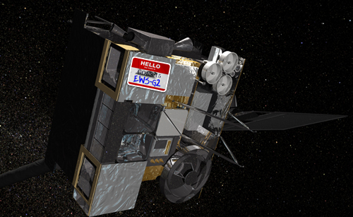
How the expanding AWS-1-3 band rollout affects HRIT/GRB and HRPT reception.

AWS-3 antenna

While the main 4G and 5G frequency is above the band that most Geo Stationary satellites like GOES-R series use, the issues that arise are the AWS-1 and 3 Bands that allows towers to talk to and from smart cell phones, act as repeaters, and are used to ‘fix’ areas that have poor cell coverage. They use a band plan called Advanced Wireless Service, AWS is the term the FCC uses for radio communication services licensed in the bands listed under Part 27 of the FCC’s rules. The services provided by AWS licensees are limited only by the Fixed and Mobile allocations of the spectrum designated for AWS and the rules of the service that the Commission adopts for the bands to address interference matters.

The AWS-3 Spectrum

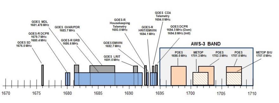
These spectrum bands are collectively known as AWS-3 which include the frequencies of 1695-1710 MHz, 1755-1780 MHz and 2155-2180 MHz bands (GOES-R HRIT is on 1694.1MHz). The AWS-3 Report and Order required that commercial operators successfully coordinate with Federal incumbents before operating in certain Protection Zones.

Ligado signal received with a GOES 16 dish.

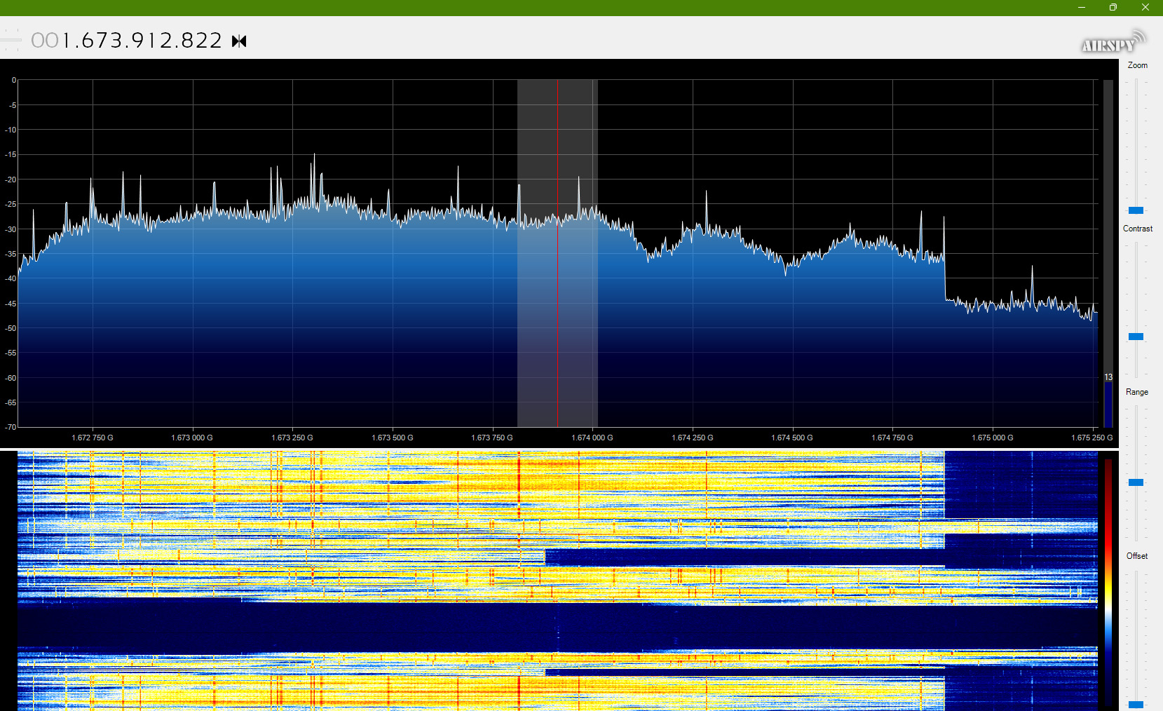
Additionally, there can be interference from Ligado Networks, formerly known as LightSquared, an American satellite communications company. Ligado Networks has 40 MHz of spectrum licenses in the nationwide block of 1500 MHz to 1700 MHz spectrum in the L-Band. With it, the company is developing a satellite-terrestrial network to support the emerging 5G market and Internet of Things applications. This company also operates the SkyTerra 1 satellite on an inclined orbit. 152 Transponders (L and Ku band) to provide 4G-LTE open wireless broadband network coverage to North America including Alaska, Hawaii, Puerto Rico, the Virgin Islands, Mexico and the Caribbean Basin. The 1670-75 MHz is a 5 MHz signal from Ligado and can be picked up with larger dishes and cause interference issues.

That’s great if you’re living in a protection zone like Suitland Maryland, Home of NOAA, or WCDAS in Wallops Island, VA, or the Table Mountain Test Range. But…..most of us are not Federal agencies operating in Protection Zones. This is such a problem that NOAA has scientists studying the interference with a project called RFIMS (Radio Frequency Interference Monitoring
System).

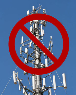
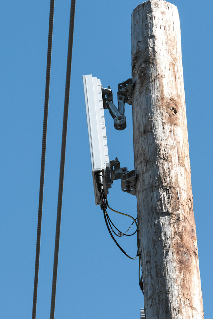
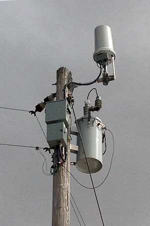
The towers are but one part of the Digital Infrastructure System, these are four sectors of digital infrastructure, including towers, data centers, fiber, and small cells & distributed antenna systems (DAS). AWS-3 can and is used in many of the DAS systems, so the receiver/transmitter might not be on a tower. I know in my small city, one of the big cell sites is on a City-owned water tower, and in the town where I work, a DAS is mounted to the back of a billboard near a shopping center.

As a way of describing by example of what this AWS-1-3 issue can cause, imagine you like to light up your backyard at night only with a 75 watt red light spotlight, your happy, your little yard looks like a scene from Red Mars. Then, unbeknownst to you, your neighbor installs on top of a tall telephone pole a 500-watt football stadium light that shines down 24/7, and on top of that, it flickers! So now you can only see your little red light shining during the times the neighbor’s stadium light flickers.

Example AWS-3 antenna
AWS-5G antenna

Now imagine the same scenario, except switch to radio frequencies, you are happily receiving GRB/HRIT, with very few drops, then BAM! the local mobile telecommunications company adds to the local cell tower an AWS-3 system to support the 5G network. Or, worse, they start installing mini AWS-3 repeaters all over the city you live in. The same effect, that powerful transmitter can overwhelm the capabilities of your receiving station. Drops begin to skyrocket, you start losing packets, your images have huge gaps in them…This is happening now to amateur receiving stations all over where AWS-1 and 3 is being deployed.

To make matters worse, most of these signals also come from UE, User Equipment, that’s right, your cell phone, or your neighbor’s phone could be wrecking your signal!!

But you may not be out of the woods yet, another looming concern is when Dish Network starts deploying its new network as their uplink band is 1695-1710 MHz. Dish was licensed to use Band 70 which combines three spectrum blocks encompassing DISH’s current AWS-4 spectrum as downlink (2000-2020 MHz), DISH’s H block downlink spectrum (1995-2000 MHz), and unpaired AWS-3 uplink spectrum (1695-1710 MHz). Dish, T-Mobile, Verizon, Amazon, and other telecoms are rushing to deploy SA, Stand Alone 5G network in this range. SA will also permit massive IoT on the network. The 5G core can support up to one million devices within a square kilometer, thousands more than what previous cellular standards could support.
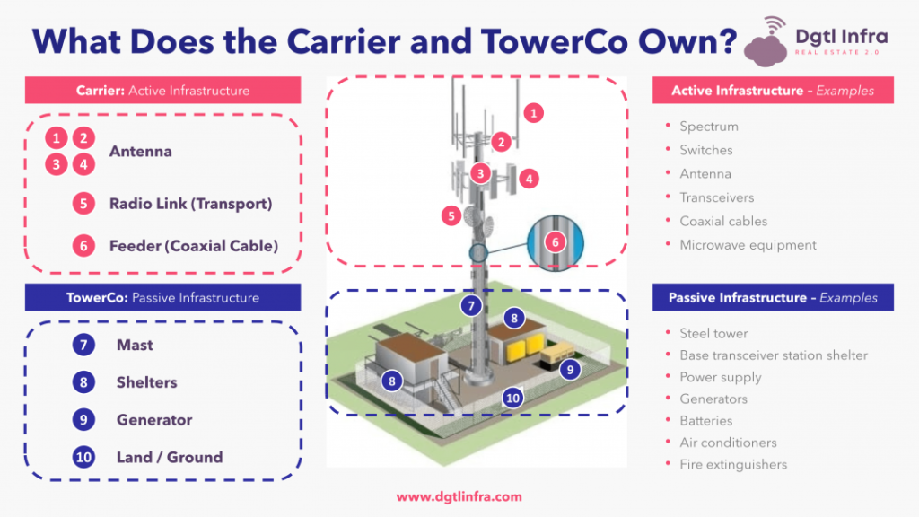

Who Owns What?

The Towers themselves are typically not owned by the big three – Verizon, AT&T, and T-Mobile, rather they lease from the tower company, space, and services of the tower. The 3 biggest Tower Companies are American Tower, Crown Castle, and SBA Communications. Here is how they lease to the top three tenants.

American Tower

The company’s three largest tenants are AT&T (19% of revenues), T-Mobile (18% of revenues), and Verizon (14% of revenues).

Crown Castle

The company’s three largest tenants are T-Mobile (35% of revenues), AT&T (22% of revenues), and Verizon (18% of revenues).

SBA Communications

The company’s three largest tenants are T-Mobile (40% of revenues), AT&T (32% of revenues), and Verizon (19% of revenues).

Graphic by https://dgtlinfra.com/

This is not just a problem for cities and urban areas, I have spoken to several folks who have had issues in big cities, large neighborhoods, and other urban areas. Surprisingly I got a message from a guy who has an APT and HRIT receiver in his backyard on his 600-acre farm in Oklahoma. He never thought he’d have an interference issue, but he did have one problem, being in the middle of nowhere he had virtually no cell phone coverage. So he called and wrote his cell phone carrier and complained, and they agreed to help! They came out and at their cost mounted a cell phone booster on the top of his grain silo. And, wait for it…. he could still receive APT, but those swirly interference lines appeared making the image terrible, and his HRIT failed altogether, while his vit average only increase by about 50 on average, he was getting 2000-4000 drops per day! So being the resourceful farmer/high tech engineer, he tried a test and shut off power to the grain elevator system. Instantly the drops disappeared and so did his cell phone signal. Unfortunately, he needed cell phone coverage for his business, so he has temporarily shut off his HRIT receiver. He has purchased the filters listed toward the end of this article, but being spring has not had the time to install them.

What can you do?

Protection zone for Cape Canaveral AFS, FL.
Protection Zone for Cape Canaveral AFS, FL.

Well, first you should file a complaint with the FCC, unless of course, you are one of the forty-seven Federal earth stations that receive satellite signals in the 1675-1695 MHz
band on a primary basis and on a co-primary basis in the 1695-1710 MHz band and will continue to do so indefinitely, then you’re in a ‘Protection Zone’. I am assuming you’re not, so file a complaint with the FCC, go to this site https://consumercomplaints.fcc.gov/hc/en-us click on RADIO and fill it out with as much detail as you can, especially these points:

  • When your problem first started
  • The frequencies you receive on
  • The impact to your system
  • If you can find them, the locations of and the proximity to your receiver.
  • Again, if you can find out the names of the cell tower operator.
  • Ask to be notified of a resolution, ask for financial remediation from the cell company to pay to have them provide filters, LNA’s, new dish, etc. (The squeaky wheel gets the oil theory).
  • Also ask to have the FCC send notifications to the cell companies in your area of your complaint.

What to do while you’re waiting for the FCC

Search for the towers in your area, take a drive, ride your bike, take a walk. Look for an identification plate on the tower, the pole, the fence, or the building. Do not enter any area owned by the company- that’s a crime, and I don’t think you can set up a satellite station in a Federal Penitentiary. Then, if you find the information, use the list below and contact them, ask to speak to an engineer, and that you are calling about EMI interference from their equipment OR the carrier that is leasing space on that tower and that it is impacting your ability to receive satellite weather data. Have the following ready:

  • When your problem first started
  • The frequencies you receive on
  • The impact to your system
  • The addresses or tower numbers of the towers you think are impacting your receiver.
  • Send them a map of the tower(s) in question and your rigs location.
  • Specifically mention interference from AWS-3 bands (it may be that the tower you think is causing the issue, is not in fact the problem.)

Use this list of 131 Companies – Note that many of these are international as well.

RankCompanyTower Count
1American Tower41,886
2Crown Castle40,567
3SBA Communications17,306
4Vertical Bridge5,089
5United States Cellular Co.4,270
6Melody Wireless Infrastructure1,682
7Peppertree Capital 1,023
8Tillman Infrastructure LLC995
9BNSF Railroad941
10Time Warner653
11Parallel Infrastructure650
12Diamond Communications637
13Phoenix Tower International620
14TowerCo620
15Tower Ventures561
16Affiniti516
17Union Pacific Railroad Company513
18SkyWay Towers510
19C Spire Wireless507
20Industrial Tower and Wireless495
21Mediacom Communications424
22T-Mobile Towers403
23Norfolk Southern Railway Co.390
24Lightower368
25Subcarrier Communications367
26Horvath Communications348
27Cumulus Broadcasting336
28Union Telephone Company322
29Century Link311
30Charter Communications291
31Tower Com276
32Central States Tower265
33Townsquare Media250
34General Communication, Inc.249
35Sprint Sites USA236
36Southern Linc220
37Entergy192
38Everest179
39Pegasus Wireless172
40ForeSite LLC164
41Cox Communications163
42CitySwitch154
43Shenandoah Mobile Company151
44Mobilitie149
45Tarpon Towers ll144
46Communications Enhancement140
47Nexstar Media Group139
4852 Eighty Partners135
49Nova Towers128
50Entercom114
51Branch Communications112
52Day Wireless Systems107
53Pacific Gas & Electric104
54NTCH ClearTalk103
55Municipal Communications103
56Frosty Towers101
57Milestone Communications95
58Georgia Power Company93
59Clearview Tower Company, LLC90
60Barinowski Investment Co., L.P.88
61Badger Towers84
62Performance Dev. Group84
63Alabama Power Company83
64Heartland Tower82
65Communications Sales & Leasing81
66Grain Management76
67Duke Energy Carolinas73
68Cellular Network Partnership73
69Baltimore Gas & Electric69
70K2 Towers68
71Capital Telecom66
72American Family Association64
73APC Towers61
74Tower Acquisition59
75TowerKing54
76Wireless Asset Group53
77Mid Continent Communications51
78Harmoni Towers51
79Bright House Networks50
80Message Center Management49
81Tower Sites48
82Questar InfoComm46
83Atlas Tower46
84Hayes Towers45
85Mauna Towers45
86Centerline Communications45
87Telecom Tower Group43
88Spirit Communications42
89XIT Communications42
90RG Towers41
91American Electric Power38
92South Carolina Educational TV36
93Telava Wireless36
94Wireless Properties35
95QMC Telecom35
96St. Charles Tower (SCT Services)34
97MidAtlantic Tower34
98Alaska Power & Telephone33
99Alaska Communications33
100Prime Tower31
101MidAmerica Towers30
102Bay Communications29
103Com Site West28
1041 Source Towers28
105Great Plains Tower Properties23
106Towers of Texas23
107Bluegrass Wireless23
108STC Towers23
109Allcomm Wireless22
110Community Wireless Structures20
111WhiteRock Holdings20
112ERS Tower Services19
113Shared Towers19
114Louis Dreyfus Pipeline19
115Centre Communications18
116Minnesota Towers, Inc.17
117JNS Tower17
118Gulf States Towers17
119Blue Ridge Telecom16
120Morris Communications Corp.15
121Datapath Tower15
122Highpoint Tower Technology15
123Clear Signal Towers15
124Dragon Communications15
125NexTower, LLC14
126Tribune Media12
127Communication & Control, Inc.11
128Hemphill Corporation10
129Horizon Tower10
130ClearShot Communications10
131Arcadia Towers10

Use this site to help you find towers in your area

Cellmapper.net You’ll have to do some digging, but it can provide a lot of info, but a lot of those small neighborhood spots are not always added.

Another great tool is https://www.antennasearch.com/ This is a very detailed list and its nice, because it provides a map, and when you find an antenna in your area, you can click on it and it will populate a google earth map of the tower!

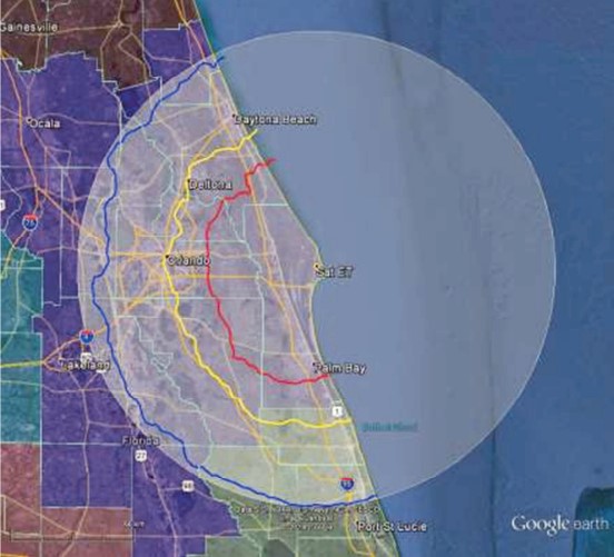
Want to see maps of AWS-3 coverage?

This is a bit staggering-

The FCC said bidding in the AWS-3 spectrum auction, known as auction 97, closed after 341 rounds of bidding. Total provisional winning bids came in at a record $44.899 BILLION. That’s far more money than the FCC raised in its previous spectrum auctions.

The FCC set a reserve price on the auction of around $10 billion. Analysts had predicted that the auction would raise anywhere from $10 billion to $20 billion. But the event has raised far more than anyone in the industry expected. And because of this, basically, the entire country is one big AWS-3 blocked-up map. This involved 65 MHz of the spectrum which would mostly be used by AT&T, Verizon and T-Mobile.

Google Image search for AWS-3 Maps from many band owners…

What can you do to filter out the AWS-3 interference.

If the FCC and/or the telecoms do not, or can not help you can try to filter…

There are some products that can be added to a receiving station to help and/or alleviate the AWS-3 band interference.

While many, many of us use the Nooelec GOES+ Sawbird for our systems, for GOES/LRIT/HRIT/HRPT Applications. it has a center frequency of 1688MHz so it will filter out most signals on either side of the center, but those lower-end AWS-1 frequencies can and do still get in.

You can get a specialized filter for AWS-3 bands, but they are intended for commercial use and are very expensive. There is however a low-cost way of adding additional filtering to your receiving station.

Photo courtesy M. Nagle

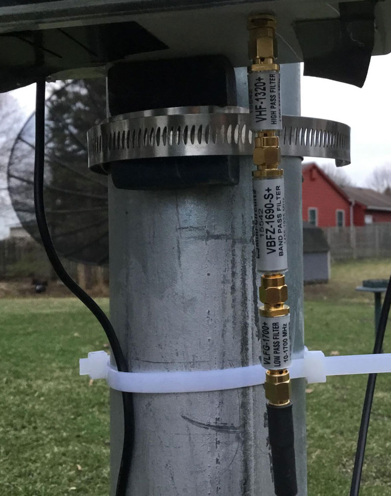
This involves trying them individually, starting with the VBFZ-1690-S+ (which might be enough all by itself), or in pairs, or all three by ‘stacking’ several filters from the company Mini-Circuits inline BEFORE the Sawbird+.

  • VHF-1320+ LTCC High Pass Filter, 1700 – 3800 MHz
  • VBFZ-1690-S+ Connectorized Band Pass Filter, 1455-1925 MHz
  • Vlfg-1700+ LTCC Low Pass Filter, DC – 1700 MHz


Hopefully, you are not affected…yet… but if you are, or you will be – Good Luck!

Tags: hardware Satellite

Post navigation

❮ Previous Post: NOAA’s GOES-T Reaches Geostationary Orbit, Now Designated GOES-18
Next Post: GOESRECV-PS ❯

You may also like

Satellites
Post Processing of received imagery.
December 28, 2021
Satellites
Invited to present at SSEC CMISS
August 28, 2020
Hardware
The new CCOR instrument aboard GOES-U
July 7, 2024
Interesting stuff you should know!
Global cloud layers on your Devices
July 8, 2025

Please, Help Support USRadioguy.com

If you like what I do please support me on Ko-fi, It really means a lot, every bit helps!

Hardware Humor Imagery Processing Interesting stuff you should know! Launch News Life News Product Review Satellites Science Software Space Weather Uncategorized VLOG

Alphabetical Listing of all Pages on site:

  • 36-Hour Imagery Processing script
  • 3D animation of realtime data
  • A PORTABLE WWII ERA “MORALE RADIO”
  • About Me
  • ADS-B Reception
  • Allsky Camera
  • AN/GRR-5 THE ANGRY 5
  • BD-71 Field Switch Board and EE-8B Field Telephones
  • Current GOES 16 & 18 False Color Satellite Imagery
  • Custom Color Lookup Table
  • Custom Imagery Scripts for GOES
  • Daily 3D view of Earth
  • Daily Global Composites
  • Decoding EWS-G1 or GOES-13
  • Drifting a geostationary satellite
  • DRONE FUN
  • Even the kitchen sink
  • GEO-RING COMPOSITES
  • GEO-SAT PI FRAME
  • Geo-stationary Satellite Imagery Reception
  • Global Weather Data
  • GOES 19&18 – Last 96 Hours of Imagery
  • GOES BAND IMAGERY
  • GOES GRB Reception
  • GOES receiving in Windows for SatDump
  • GOES-18 Preparing for a new satellite
  • GOES-R Series Multimedia Tour
  • GOES-U (19) Countdown to Launch
  • GOES16 A full year of received imagery
  • Ground Station Map
  • High Resolution Imagery
  • Home
  • House History
  • HRIT/EMWIN & GRB
  • HRPT Satellite Tracking and Capture
  • Hubble Space Telescope Data Processing
  • Inmarsat Decoding
  • Layering Fire and Hotspot Data on Meteor Sat Imagery
  • Layering Geo-Spatial Fire Data into Satellite Imagery
  • Mesoscale Imagery Defined
  • METEOR M2- Series
  • MODIS VIIRS Global Coverage
  • My Other Interests
  • NASA, NOAA, Military, GOVT dish, and tower stations.
  • National Hurricane Data
  • Newsletter terms & conditions
  • NOAA & Meteor APT and LRPT RECEPTION
  • Online Satellite Imagery and Information
  • Optimizing a WIFI Grid Antenna for Maximum Efficiency
  • ORBITAL DYNAMICS 101
  • Orbitron, Gpredict, and PSTRotator with new TLE format
  • PI Based Broadcastify Server
  • Pi Based Picture Frame
  • Presentations
  • Privacy Policy
  • Programming the PI for goestools operation
  • R-100/URR 1944 MORALE RADIO
  • RADIO SET SCR-284
  • Rare Captures
  • Receiving GOES 18,19 with goestools
  • Receiving GOES HRIT with SATDUMP
  • Receiving the Funcube Amateur Satellite
  • Satdump for Meteor and NOAA decoding
  • Satellite Finder
  • Satellite Frequencies
  • Satellite Ground Stations
  • Satellite Tracking
  • Security
  • SETEC Astronomy
  • Solar Power for PI
  • South America GOES 16
  • Space Weather
  • Stray Light Zone (SLZ)
  • Thanks!
  • The quest for True Color Imagery
  • Tried and Tested Hardware
  • Usradioguy Blogs
  • Usradioguy Merchandise
  • USRadioguy Newsletter
  • USRadioguy VLOGS
  • USRADIOGUY Youtube Page
  • VIBRATOR CONVERSION MODULE
  • Viterbi, R/S Errors, Packets
  • VS-3 VIBRATOR CONVERSION
  • What is RTL-SDR?
  • WWII Audio Page
  • WWII K-24 Aerial Camera
  • WWII RADIO
  • WxtoImg Fix
  • Zombie Satellites

Hardware Humor Imagery Processing Interesting stuff you should know! Launch News Life News Product Review Satellites Science Software Space Weather Uncategorized VLOG

Satellite And Weather Related Feeds

  • CIMSS Satellite Blog
  • USRadioguy.com
  • wildfires
  • NASA Earth Observatory
  • SPC Particularly Dangerous Situation (PDS) Tornado/Severe Thunderstorm Watch
  • satellites
  • Satellites News -- ScienceDaily
  • Satellite Liaison Blog
Wildfire in Ontario produces a large pyrocumulonimbus cloud
American Samoa’s Wettest Year Gets Wetter
Deadly flash flooding in Ruidoso, New Mexico
Global cloud layers on your Devices
End Of Life for NOAA 15 and 19?….not so fast…
Vitality GOES
Vitality GOES
The fire cycle
Unmasking the complicated chemistry of wildfire smoke: What's in it?
NOAA unveils powerful convergence of AI and science with revolutionary Next-Generation Fire System technology
The Salty Lake of Gas Hure
Greenland’s Bejeweled Ice Sheet
Manitoba Burning
Manitoba Burning
SPC PDS Severe Thunderstorm Watch 399
Five historically huge solar events
65 years since the world’s first weather satellite
Investing in America: NOAA's Science, Service and Stewardship in Action
Earth’s weather satellites just spent 10 years watching Venus — here’s what they found
Record-breaking 10-billion-year radio halo just rewrote the universe’s origin story
Massive thread of hot gas found linking galaxies — and it’s 10 times the mass of the Milky Way
The Need for Speed: OCTANE Cloud-Top Winds at SPC
Summer Storms, Flooding Target Mid-Atlantic
Southwest Thunderstorms – Late June 2025
  • Facebook Geo Stationary Satellites
  • Usradioguy Facebook
  • Instagram
  • Reddit
  • Github
  • Linkedin

Copyright © 2025 USRadioguy.com - All Rights Reserved. All material protected by Fair Use Section 107 of the Copyright Act. This site is Verified and Secured with 256 bit SSL encryption