Skip to content
USRADIOGUY

USRadioguy.com

Welcome to USRadioguy.com – Unlocking the Potential of Software Defined Radio

  • Home
    • Home of USRadioguy
    • USRadioguy Newsletter
    • Tried and Tested Hardware
    • What is RTL-SDR?
    • Global Weather Data
  • Satellite Reception
    • Geo Stationary Satellites
      • Geo-stationary Satellite Imagery Reception
      • GOESTOOLS on the PI
      • Update Goestools for GOES 18,19
      • Receiving GOES with SatDump CLI Mode
      • GOES receiving in Windows for SatDump GUI
      • Decoding EWS-G1/EWS-G2
      • GOES GRB Reception WIP
      • Optimizing a WIFI Grid Antenna for Maximum Efficiency
    • APT Satellites
      • APT RECEPTION
      • Satdump for Meteor and NOAA decoding
      • METEOR M2- Series
      • WxtoImg Fix
      • Converting to new TLE format
      • Layering Fire and Hotspot Data on Meteor Sat Imagery
      • HRPT Satellite Tracking and Capture
    • Receiving Other Satellites
      • Inmarsat Decoding
      • Receiving the Funcube Amateur Satellite
    • User Maps and Dish Pointers
      • Satellite Dish Pointer
      • User Global Ground Station Maps
      • Usermap rendered with Cesium
      • Global Map of Govt Dish Stations
    • Satellite Details & Information
      • ORBITAL DYNAMICS 101
      • HRIT/EMWIN & GRB Defined
      • Mesoscale Imagery Defined
      • Viterbi, R/S Errors, Packets
      • GOES BAND IMAGERY
      • Stray Light Zone (SLZ)
      • Drifting a geostationary satellite
      • GOES-R Series Multimedia Tour
      • Online Satellite Imagery and Information
      • Satellite Frequencies
      • Solar and Space Weather
  • Satellite Imagery
    • IMAGERY- Current GOES East & West HRIT Satellite Imagery
    • IMAGERY- GOES 16&18 – Past 96 Hours of Imagery
    • High Resolution Imagery
    • Daily 3D view of Earth
    • NOAA APT Satellite imagery
    • PlanetMaker
    • GOES16 A full year of received imagery
  • Imagery Processing
    • Custom Color Lookup Table & Gradients
    • GOES-R Custom Imagery Scripts
    • Global geo-ring composites
    • MODIS VIIRS Global Coverage
    • 3D Satellite Tracking
    • The quest for True Color Imagery
    • 3D animation of realtime data
    • Layering Geo-Spatial Fire Data into Satellite Imagery
    • Orbital dynamics and the Moon
    • National Hurricane Data
  • News, VLOGS & BLOGS
    • News & USRadioguy Blogs
    • USRadioguy VLOGS
  • Project Lab
    • Orbital Information and Visualizations
      • Enhanced Planet Earth
      • Satellites in Orbit
      • Solar System
      • Objects in Orbit
    • Current Station Weather
      • Current Groundstation Weather
      • Global Weather Data
      • Space Weather
    • WWII RADIO
      • WWII K-24 Aerial Camera
      • WWII RADIO
      • RADIO SET SCR-284
      • VS-3 VIBRATOR CONVERSION
      • VIBRATOR CONVERSION MODULE
      • BD-71 Field Switch Board and EE-8B Field Telephones
      • R-100/URR 1944 MORALE RADIO
      • A PORTABLE WWII ERA “MORALE RADIO”
      • AN/GRR-5 THE ANGRY 5
      • WWII Audio Page
    • Raspberry Pi Projects
      • ADS-B Reception
      • Allsky Camera
      • Pi Based Picture Frame
      • PI Based Broadcastify Server
      • Solar Power for PI
    • Hubble Space Telescope Data Processing
    • Zombie Satellites
    • DRONES
  • About Me
    • About Usradioguy
      • SETEC Astronomy
    • Tried and Tested Hardware
    • Rare Captures
    • My Other Interests
    • Presentations
    • Merchandise
    • Privacy Policy
  • Home
  • Life
  • Geo Magnetic Storm 04.23.2023

Geo Magnetic Storm 04.23.2023

Posted on April 28, 2023July 10, 2024 By Carl
Life, News, Satellites, Science, Space Weather

Loading

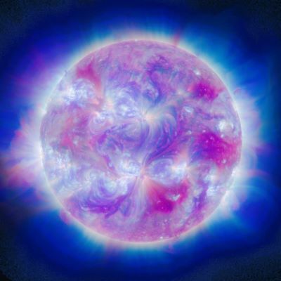
On April 21, 2023, a coronal mass ejection (CME) occurred on the sun, resulting in the emission of a high-speed burst of plasma that traveled towards Earth at a velocity of approximately two million miles per hour. This event triggered a severe geomagnetic storm that attained level 4 out of 5 on NOAA’s space weather G-scale. The storm reached its peak at 3:26 p.m. EDT on April 23.

NOAA’s G-scale is a system that is used to measure the intensity of geomagnetic storms caused by solar activity. The scale ranges from G1 to G5, with G1 being a minor storm and G5 being a severe storm. The intensity of the storm is determined by measuring the disturbance in the Earth’s magnetic field caused by the solar activity.
Each level on the G-scale corresponds to a range of values for the disturbance level in the Earth’s magnetic field. For example, a G1 storm corresponds to a disturbance level between 5 and 6 nanoteslas (nT), while a G5 storm corresponds to a disturbance level greater than 200 nT.

The G-scale is an important tool for assessing the potential impact of solar storms on various technological systems on Earth, including power grids, communication systems, and navigation systems. NOAA’s Space Weather Prediction Center uses the G-scale to provide alerts and warnings to industries and government agencies to help mitigate the potential effects of these storms.
Credit: NASA/Joy Ng

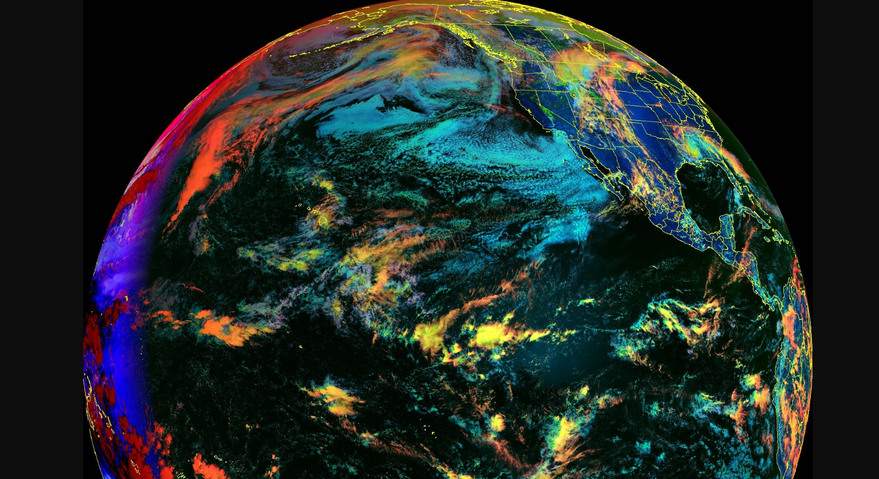
The heightened solar radiation and associated geomagnetic storms can cause several adverse effects. For instance, they can disrupt power grids, radio signals, and communication systems on Earth. These events can also interfere with satellite operations and GPS navigation capabilities. Astronauts in space are especially vulnerable as the radiation they are exposed to outside Earth’s protective atmosphere can result in radiation poisoning or other severe health effects. Additionally, the storms may cause spectacular auroras on Earth.

Aurora above a bay in Lake Superior Image by R Halvorsen

This recent event was the third severe geomagnetic storm (G4) since the onset of Solar Cycle 25 in 2019. The previous storms occurred on November 4, 2021, and March 24, 2023. NOAA’s DSCOVR spacecraft helped to measure the elevated solar winds associated with these storms and provided data that informed the subsequent geomagnetic storm forecasts.

NOAA satellites, including the Geostationary Operational Environmental Satellite (GOES) series, are vital in monitoring solar activity and forecasting space weather events. Given the unpredictable nature of solar flares and CMEs, the Space Weather Prediction Center relies on this data to issue alerts and predictions in real-time. In this particular case, the NOAA forecasters provided multiple warnings for the geomagnetic storm, and offered decision support to customers to minimize the adverse impacts.

GOES satellites also carry crucial scientific instruments, such as the Extreme Ultraviolet and X-ray Irradiance Sensors (EXIS), which monitor the sun’s electromagnetic radiation, serving as an essential early warning system for the onset of flares. The Space Environmental In-Situ Suite (SEISS) helps evaluate electrostatic discharge risks and radiation hazards to astronauts and satellites, while the Magnetometer measures the Earth’s magnetic field.

For more Space Weather click here!

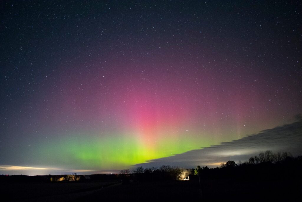
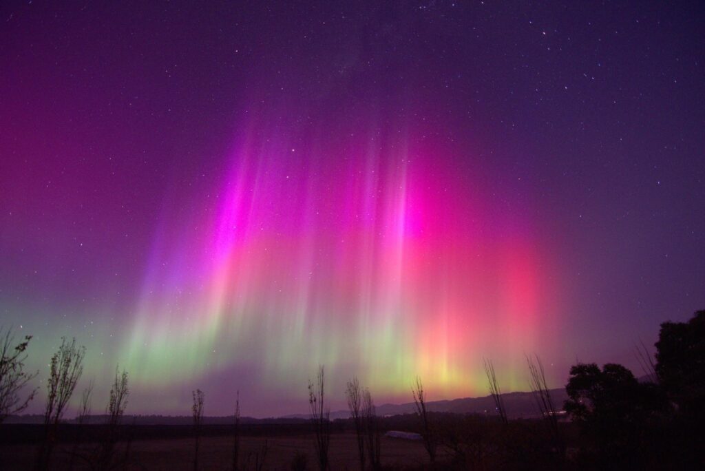
Images from Australian Meteorological Service, Steve Brown- Alberta Canada, Beth Ronsin, Utah USA.

What is a Solar Cycle 25?

Solar Cycle 25 is the current cycle of solar activity, which began in December 2019. The cycle is part of a regular pattern of solar activity known as the solar cycle, which is an 11-year cycle that is driven by the Sun’s magnetic field.

During a solar cycle, the Sun goes through periods of high activity, characterized by numerous sunspots, solar flares, and coronal mass ejections (CMEs), and periods of low activity, where the Sun is relatively quiet. These periods are called solar maximum and solar minimum, respectively.

Solar Cycle 25 is expected to reach its maximum in the years 2024-2025, although the exact timing and strength of the maximum are difficult to predict. The cycle is being closely monitored by scientists and researchers around the world, who use a variety of tools and techniques to study the Sun and its impact on Earth.

One important tool for monitoring solar activity is the Solar Dynamics Observatory (SDO), a spacecraft launched by NASA in 2010 that observes the Sun in high definition. The SDO provides scientists with detailed images of the Sun’s surface and magnetic field, allowing them to study the evolution of sunspots and other features over time.

Another important tool is the Solar and Heliospheric Observatory (SOHO), a joint mission between NASA and the European Space Agency (ESA) launched in 1995. SOHO observes the Sun from a position about 1 million miles from Earth, providing scientists with data on the solar wind, CMEs, and other phenomena.

Understanding solar activity is important because it can have a significant impact on Earth’s atmosphere and technology. During a solar maximum, the Sun’s magnetic field becomes highly distorted, and large-scale eruptions such as CMEs and solar flares can occur.

To better understand and predict space weather events, scientists and researchers around the world are studying Solar Cycle 25 using a variety of tools and techniques. By studying the Sun and its impact on Earth, they hope to develop better ways to protect our planet and our technology from the effects of solar activity.

Tags: Space Weather

Post navigation

❮ Previous Post: NOAA Requests proposals to limit 5G (6G) interference.
Next Post: Meteor M No. 2-3 ❯

You may also like

Hardware
Going Green, and to Extremes!
August 15, 2022
Satellites
GOES-T Encapsulated inside payload fairings
February 11, 2022
Satellites
Goestools for Windows
July 14, 2023
Hardware
What do Quaker Oats and Satellite Reception have to do with each other?
March 25, 2021

Please, Help Support USRadioguy.com

If you like what I do please support me on Ko-fi, It really means a lot, every bit helps!

Hardware Humor Imagery Processing Interesting stuff you should know! Launch News Life News Product Review Satellites Science Software Space Weather Uncategorized VLOG

Alphabetical Listing of all Pages on site:

  • 36-Hour Imagery Processing script
  • 3D animation of realtime data
  • A PORTABLE WWII ERA “MORALE RADIO”
  • About Me
  • ADS-B Reception
  • Allsky Camera
  • AN/GRR-5 THE ANGRY 5
  • BD-71 Field Switch Board and EE-8B Field Telephones
  • Current GOES 16 & 18 False Color Satellite Imagery
  • Custom Color Lookup Table
  • Custom Imagery Scripts for GOES
  • Daily 3D view of Earth
  • Daily Global Composites
  • Decoding EWS-G1 or GOES-13
  • Drifting a geostationary satellite
  • DRONE FUN
  • Even the kitchen sink
  • GEO-RING COMPOSITES
  • GEO-SAT PI FRAME
  • Geo-stationary Satellite Imagery Reception
  • Global Weather Data
  • GOES 19&18 – Last 96 Hours of Imagery
  • GOES BAND IMAGERY
  • GOES GRB Reception
  • GOES receiving in Windows for SatDump
  • GOES-18 Preparing for a new satellite
  • GOES-R Series Multimedia Tour
  • GOES-U (19) Countdown to Launch
  • GOES16 A full year of received imagery
  • Ground Station Map
  • High Resolution Imagery
  • Home
  • House History
  • HRIT/EMWIN & GRB
  • HRPT Satellite Tracking and Capture
  • Hubble Space Telescope Data Processing
  • Inmarsat Decoding
  • Layering Fire and Hotspot Data on Meteor Sat Imagery
  • Layering Geo-Spatial Fire Data into Satellite Imagery
  • Mesoscale Imagery Defined
  • METEOR M2- Series
  • MODIS VIIRS Global Coverage
  • My Other Interests
  • NASA, NOAA, Military, GOVT dish, and tower stations.
  • National Hurricane Data
  • Newsletter terms & conditions
  • NOAA & Meteor APT and LRPT RECEPTION
  • Online Satellite Imagery and Information
  • Optimizing a WIFI Grid Antenna for Maximum Efficiency
  • ORBITAL DYNAMICS 101
  • Orbitron, Gpredict, and PSTRotator with new TLE format
  • PI Based Broadcastify Server
  • Pi Based Picture Frame
  • Presentations
  • Privacy Policy
  • Programming the PI for goestools operation
  • R-100/URR 1944 MORALE RADIO
  • RADIO SET SCR-284
  • Rare Captures
  • Receiving GOES 18,19 with goestools
  • Receiving GOES HRIT with SATDUMP
  • Receiving the Funcube Amateur Satellite
  • Satdump for Meteor and NOAA decoding
  • Satellite Finder
  • Satellite Frequencies
  • Satellite Ground Stations
  • Satellite Tracking
  • Security
  • SETEC Astronomy
  • Solar Power for PI
  • South America GOES 16
  • Space Weather
  • Stray Light Zone (SLZ)
  • Thanks!
  • The quest for True Color Imagery
  • Tried and Tested Hardware
  • Usradioguy Blogs
  • Usradioguy Merchandise
  • USRadioguy Newsletter
  • USRadioguy VLOGS
  • USRADIOGUY Youtube Page
  • VIBRATOR CONVERSION MODULE
  • Viterbi, R/S Errors, Packets
  • VS-3 VIBRATOR CONVERSION
  • What is RTL-SDR?
  • WWII Audio Page
  • WWII K-24 Aerial Camera
  • WWII RADIO
  • WxtoImg Fix
  • Zombie Satellites

Hardware Humor Imagery Processing Interesting stuff you should know! Launch News Life News Product Review Satellites Science Software Space Weather Uncategorized VLOG

Satellite And Weather Related Feeds

  • CIMSS Satellite Blog
  • USRadioguy.com
  • wildfires
  • NASA Earth Observatory
  • SPC Particularly Dangerous Situation (PDS) Tornado/Severe Thunderstorm Watch
  • satellites
  • Satellites News -- ScienceDaily
  • Satellite Liaison Blog
Trout Fire in New Mexico produces a pyrocumulonimbus cloud
Blowing dust in Argentina
Canadian wildfire smoke over Alaska
End Of Life for NOAA 15 and 19?….not so fast…
Vitality GOES
Vitality GOES
Decommissioning NOAA-18
The fire cycle
Unmasking the complicated chemistry of wildfire smoke: What's in it?
NOAA unveils powerful convergence of AI and science with revolutionary Next-Generation Fire System technology
Earth’s Clouds on the Move
Seasonal Breakup in the Amundsen Gulf
Egypt’s Mediterranean Coast
SPC PDS Severe Thunderstorm Watch 399
Five historically huge solar events
65 years since the world’s first weather satellite
Investing in America: NOAA's Science, Service and Stewardship in Action
Satellite measures CO2 and NO2 simultaneously from power plant emissions for the first time
Existing international law can help secure peace and security in outer space
Small, faint and 'unexpected in a lot of different ways': Astronomers make galactic discovery
Late-Season Atlantic Hurricane-Force Low
Atmospheric River Strikes Eastern U.S.
Another Week, Another Deep South Soaker
  • Facebook Geo Stationary Satellites
  • Usradioguy Facebook
  • Instagram
  • Reddit
  • Github
  • Linkedin

Copyright © 2025 USRadioguy.com - All Rights Reserved. All material protected by Fair Use Section 107 of the Copyright Act. This site is Verified and Secured with 256 bit SSL encryption