Skip to content
USRADIOGUY

USRadioguy.com

Welcome to USRadioguy.com – Unlocking the Potential of Software Defined Radio

  • Home
    • Home of USRadioguy
    • Tried and Tested Hardware
    • USRadioguy Newsletter
    • What is RTL-SDR?
    • Global Weather Data
  • Satellite Reception
    • Geo Stationary Satellites
      • Geo-stationary Satellite Imagery Reception
      • GOESTOOLS on the PI
      • Update Goestools for GOES 18,19
      • Receiving GOES with SatDump CLI Mode
      • GOES receiving in Windows for SatDump GUI
      • Decoding EWS-G1/EWS-G2
      • GOES GRB Reception WIP
      • Optimizing a WIFI Grid Antenna for Maximum Efficiency
    • APT Satellites
      • APT RECEPTION
      • Satdump for Meteor and NOAA decoding
      • METEOR M2- Series
      • WxtoImg Fix
      • Converting to new TLE format
      • Layering Fire and Hotspot Data on Meteor Sat Imagery
      • HRPT Satellite Tracking and Capture
    • Receiving Other Satellites
      • Inmarsat Decoding
      • Receiving the Funcube Amateur Satellite
    • User Maps and Dish Pointers
      • Satellite Dish Pointer
      • User Global Ground Station Maps
      • Usermap rendered with Cesium
      • Global Map of Govt Dish Stations
    • Satellite Details & Information
      • ORBITAL DYNAMICS 101
      • HRIT/EMWIN & GRB Defined
      • Mesoscale Imagery Defined
      • Viterbi, R/S Errors, Packets
      • GOES BAND IMAGERY
      • Stray Light Zone (SLZ)
      • Drifting a geostationary satellite
      • GOES-R Series Multimedia Tour
      • Online Satellite Imagery and Information
      • Satellite Frequencies
      • Solar and Space Weather
  • Satellite Imagery
    • IMAGERY- Current GOES East & West HRIT Satellite Imagery
    • IMAGERY- GOES 16&18 – Past 96 Hours of Imagery
    • High Resolution Imagery
    • Daily 3D view of Earth
    • PlanetMaker
    • GOES16 A full year of received imagery
  • Imagery Processing
    • Custom Color Lookup Table & Gradients
    • GOES-R Custom Imagery Scripts
    • Global geo-ring composites
    • MODIS VIIRS Global Coverage
    • 3D Satellite Tracking
    • The quest for True Color Imagery
    • 3D animation of realtime data
    • Layering Geo-Spatial Fire Data into Satellite Imagery
    • Orbital dynamics and the Moon
    • National Hurricane Data
  • News, VLOGS & BLOGS
    • News & USRadioguy Blogs
    • USRadioguy VLOGS
  • Project Lab
    • OpenHamClock on Windows
    • Orbital Information and Visualizations
      • Enhanced Planet Earth
      • Satellites in Orbit
      • Solar System
      • Objects in Orbit
    • Current Station Weather
      • Current Groundstation Weather
      • Global Weather Data
      • Space Weather
    • WWII RADIO
      • WWII K-24 Aerial Camera
      • WWII RADIO
      • RADIO SET SCR-284
      • VS-3 VIBRATOR CONVERSION
      • VIBRATOR CONVERSION MODULE
      • BD-71 Field Switch Board and EE-8B Field Telephones
      • R-100/URR 1944 MORALE RADIO
      • A PORTABLE WWII ERA “MORALE RADIO”
      • AN/GRR-5 THE ANGRY 5
      • WWII Audio Page
    • Raspberry Pi Projects
      • ADS-B Reception
      • Allsky Camera
      • Pi Based Picture Frame
      • PI Based Broadcastify Server
      • Solar Power for PI
    • Your very Own Weather Satellite
    • Hubble Space Telescope Data Processing
    • Zombie Satellites
    • DRONES
  • About Me
    • About Usradioguy
      • SETEC Astronomy
    • Tried and Tested Hardware
    • Rare Captures
    • My Other Interests
    • Presentations
    • Merchandise
    • Privacy Policy
  • Home
  • Usradioguy Blogs
  • Satellites
  • Page 8

Category: Satellites

GOES-T Encapsulation

Posted on February 5, 2022September 30, 2024 By Carl
GOES-T  Encapsulation
Satellites, Science

Loading

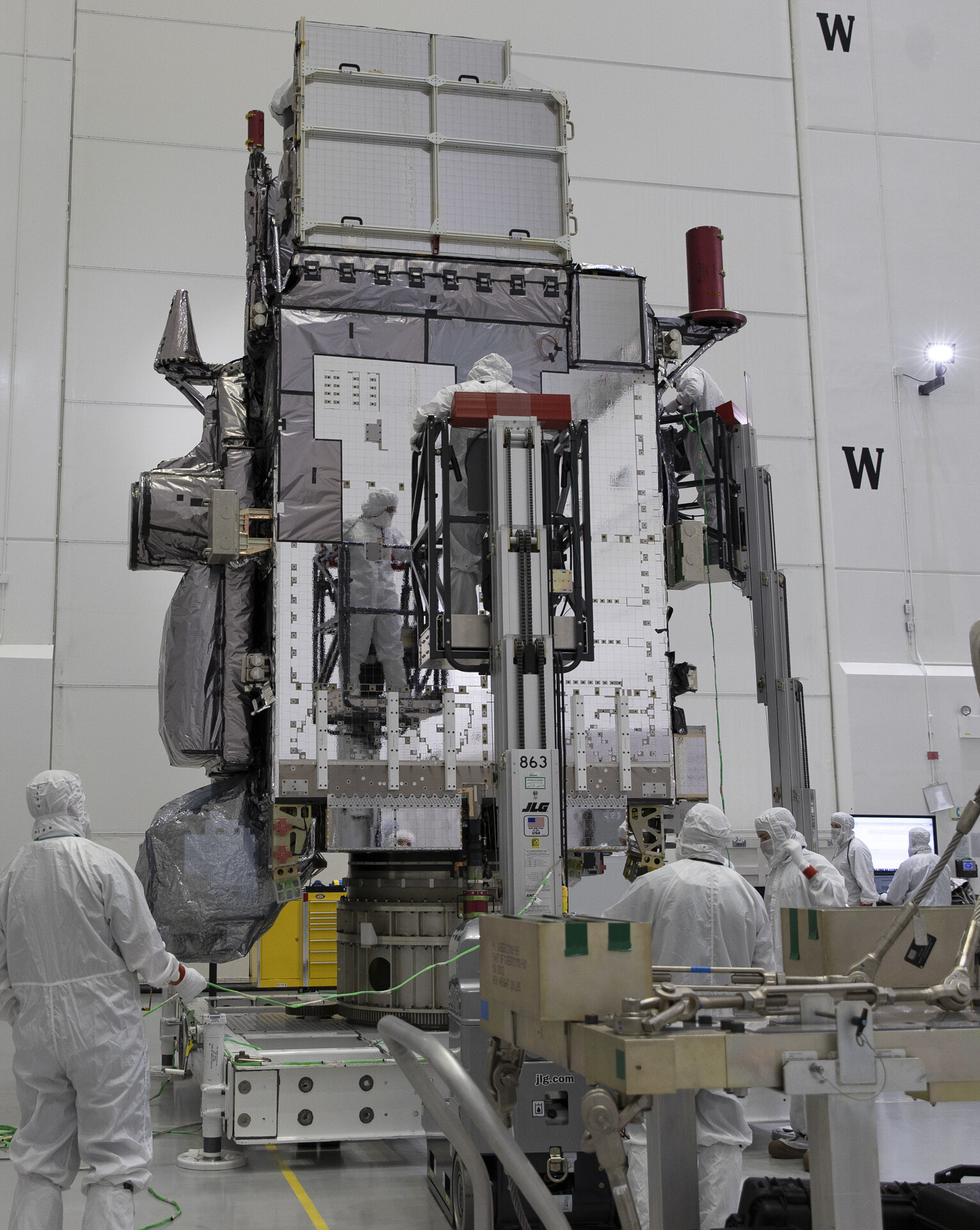
Preparing GOES-T for Encapsulation February 4, 2022. At Astrotech Space Operations facility in Titusville, Florida, technicians are now moving NOAA’s Geostationary Operational Environmental Satellite-T (GOES-T). The spacecraft is being prepared for encapsulation inside its protective payload fairings.  Photo credit: NASA/Kim Shiflett GOES-T is scheduled to launch on March 1, 2022, atop a United Launch Alliance … Delve Deeper “GOES-T Encapsulation” »

OIG reccomends changes to NOAA GOES launch schedule/storage

Posted on January 26, 2022October 6, 2024 By Carl
Satellites, Science

Loading

NOAA Should Reassess Geostationary Satellite Launch Plans The Commerce Department Inspector General warned last week that the National Oceanic and Atmospheric Administration may be increasing risk in the development of its environmental satellites. OIG auditors did not ask for a delay of GOES-T’s launch, they did ask NOAA to conduct an analysis of alternatives regarding whether to … Delve Deeper “OIG reccomends changes to NOAA GOES launch schedule/storage” »

Rocket Stacking underway for GOES-T

Posted on January 24, 2022September 23, 2024 By Carl
Rocket Stacking underway for GOES-T
Satellites, Science

Loading

Rocket Stacking underway for GOES-T United Launch Alliance, has started stacking the Atlas 5 that will launch GOES-T. The spacecraft, encapsulated within its five-meter payload fairing, is scheduled to be installed on the rocket Feb. 15 for final tests before rollout and launch. The four GEM 63 solid rocket boosters and the Centaur upper stage … Delve Deeper “Rocket Stacking underway for GOES-T” »

Post Processing of received imagery.

Posted on December 28, 2021September 23, 2024 By Carl
Post Processing of received imagery.
Satellites, Science

Loading

So, for a little over two years now, I have been receiving, directly, GOES 16,17, and Himawari 8, along with various APT satellites like Meteor M2 and NOAA 15,18, and 19. I have stored about 3.8 Terrabytes of data from these sats, and, if you’ve been following along on my website, I a constantly trying … Delve Deeper “Post Processing of received imagery.” »

GOES-T/18 Transition to Operations

Posted on December 8, 2021September 23, 2024 By Carl
Satellites

Loading

GOES-West Transition Plan – Swap of GOES-17/18 GOES-17 ABI has been operating with a Loop Heat Pipe (LHP) Anomaly for its entire lifetime which results in degraded imagery during four warm periods of each year. Recent anomalies have caused further challenges in regulating the ABI Focal Plane Module (FPM) temperatures, resulting in additional warming and … Delve Deeper “GOES-T/18 Transition to Operations” »

GOES T Launch bumped to March 1, 2022

Posted on November 18, 2021September 18, 2024 By Carl
GOES T Launch bumped to March 1, 2022
Satellites, Science, Uncategorized

Loading

Countdown to Launch: March 1st, 2022 NOAA’s GOES-T is set for liftoff on an Atlas V rocket from Cape Canaveral Air Force Station in Florida. The two-hour launch window opens at 4:38 p.m. EST. NOAA and NASA are now targeting March 1, 2022, as the new launch date for NOAA’s Geostationary Operational Environmental Satellite T … Delve Deeper “GOES T Launch bumped to March 1, 2022” »

GOES-T in Florida and ULA Rocket arrive.

Posted on November 18, 2021September 16, 2024 By Carl
GOES-T in Florida and ULA Rocket arrive.
Satellites, Science

Loading

After a truck and Super Galaxy plane ride from Colorado to Florida on November 9th, the GOES T Shipping container was opened for inspection at the Astrotech Space Operations in Titusville, Florida. The newest weather satellite was removed and orientated vertically and set up on the stand for more tests, inspections, and later fueling and … Delve Deeper “GOES-T in Florida and ULA Rocket arrive.” »

GOES-T: Road to Launch

Posted on November 9, 2021September 30, 2024 By Carl
GOES-T: Road to Launch
Satellites

Loading

Updated 11/11/2021Shipping a satellite is no small feat. GOES-T is the size of a small school bus and weighs over 6,000 pounds! The spacecraft team at Lockheed Martin in Littleton, Colorado, where GOES-T was built, carefully packed the satellite in a special shipping container that protected its sensitive instruments and functioned as a miniature cleanroom … Delve Deeper “GOES-T: Road to Launch” »

GOES-T’s launch has been delayed to March 1, 2022.

Posted on October 1, 2021September 26, 2024 By Carl
Satellites, Science

Loading

Updated 11-18-2021 NOAA and NASA are now targeting March 1, 2022, as the new launch date for NOAA’s Geostationary Operational Environmental Satellite T (GOES-T) mission. The launch was recently scheduled for February 16, 2022. However, shifts in launch dates for missions scheduled ahead of GOES-T prompted NASA, NOAA, and United Launch Alliance (ULA) to coordinate … Delve Deeper “GOES-T’s launch has been delayed to March 1, 2022.” »

NOAA to replace GOES17 satellite with GOES T ahead of schedule

Posted on June 27, 2021November 4, 2024 By Carl
NOAA to replace GOES17 satellite with GOES T ahead of schedule
Satellites

Loading

The National Oceanic and Atmospheric Administration announced plans on June 25, 2021, to move its geostationary weather satellite, which is scheduled to launch in December, into an operational role “as soon as possible.”  This advances the previous GOES-T flyout and operational status schedule by a whopping 4 years. No word as of yet for GOES … Delve Deeper “NOAA to replace GOES17 satellite with GOES T ahead of schedule” »

Posts pagination

Previous 1 … 7 8 9 Next

Please, Help Support USRadioguy.com

If you like what I do please support me on Ko-fi, It really means a lot, every bit helps!

Hardware Humor Imagery Processing Interesting stuff you should know! Launch News Life News Product Review Satellites Science Software Space Weather Uncategorized VLOG

Alphabetical Listing of all Pages on site:

  • 36-Hour Imagery Processing script
  • 3D animation of realtime data
  • A PORTABLE WWII ERA “MORALE RADIO”
  • About Me
  • ADS-B Reception
  • Allsky Camera
  • AN/GRR-5 THE ANGRY 5
  • BD-71 Field Switch Board and EE-8B Field Telephones
  • Current GOES 16 & 18 False Color Satellite Imagery
  • Custom Color Lookup Table
  • Custom Imagery Scripts for GOES
  • Daily 3D view of Earth
  • Daily Global Composites
  • Decoding EWS-G1 or GOES-13
  • Drifting a geostationary satellite
  • DRONE FUN
  • Even the kitchen sink
  • GEO-RING COMPOSITES
  • GEO-SAT PI FRAME
  • Geo-stationary Satellite Imagery Reception
  • Global Weather Data
  • GOES 19&18 – Last 96 Hours of Imagery
  • GOES BAND IMAGERY
  • GOES GRB Reception
  • GOES receiving in Windows for SatDump
  • GOES-18 Preparing for a new satellite
  • GOES-R Series Multimedia Tour
  • GOES-U (19) Countdown to Launch
  • GOES16 A full year of received imagery
  • Ground Station Map
  • High Resolution Imagery
  • Home
  • House History
  • HRIT/EMWIN & GRB
  • HRPT Satellite Tracking and Capture
  • Hubble Space Telescope Data Processing
  • Inmarsat Decoding
  • Layering Fire and Hotspot Data on Meteor Sat Imagery
  • Layering Geo-Spatial Fire Data into Satellite Imagery
  • Mesoscale Imagery Defined
  • METEOR M2- Series
  • MODIS VIIRS Global Coverage
  • My Other Interests
  • NASA, NOAA, Military, GOVT dish, and tower stations.
  • National Hurricane Data
  • Newsletter terms & conditions
  • NOAA & Meteor APT and LRPT RECEPTION
  • Online Satellite Imagery and Information
  • OpenHamClock on Windows
  • Optimizing a WIFI Grid Antenna for Maximum Efficiency
  • ORBITAL DYNAMICS 101
  • Orbitron, Gpredict, and PSTRotator with new TLE format
  • PI Based Broadcastify Server
  • Pi Based Picture Frame
  • Presentations
  • Privacy Policy
  • Programming the PI for goestools operation
  • R-100/URR 1944 MORALE RADIO
  • RADIO SET SCR-284
  • Rare Captures
  • Receiving GOES 18,19 with goestools
  • Receiving GOES HRIT with SATDUMP
  • Receiving the Funcube Amateur Satellite
  • Satdump for Meteor and NOAA decoding
  • Satellite Finder
  • Satellite Frequencies
  • Satellite Ground Stations
  • Satellite Tracking
  • Security
  • SETEC Astronomy
  • Solar Power for PI
  • South America GOES 16
  • Space Weather
  • Stray Light Zone (SLZ)
  • Thanks!
  • The quest for True Color Imagery
  • Tried and Tested Hardware
  • Usradioguy Blogs
  • Usradioguy Merchandise
  • USRadioguy Newsletter
  • USRadioguy VLOGS
  • USRADIOGUY Youtube Page
  • VIBRATOR CONVERSION MODULE
  • Viterbi, R/S Errors, Packets
  • VS-3 VIBRATOR CONVERSION
  • What is RTL-SDR?
  • WWII Audio Page
  • WWII K-24 Aerial Camera
  • WWII RADIO
  • WxtoImg Fix
  • Your very Own Weather Satellite
  • Zombie Satellites

Hardware Humor Imagery Processing Interesting stuff you should know! Launch News Life News Product Review Satellites Science Software Space Weather Uncategorized VLOG

Satellite And Weather Related Feeds

  • CIMSS Satellite Blog
  • USRadioguy.com
  • wildfires
  • NASA Science
  • SPC Particularly Dangerous Situation (PDS) Tornado/Severe Thunderstorm Watch
  • satellites
  • Satellites News -- ScienceDaily
  • Satellite Liaison Blog
Low-Earth Orbiting and Ground-Based Perspectives on the Ongoing Air Quality Event
Flash flooding in the Hill Country of Texas
Long-range transport of smoke from wildfires in Canada and northeastern Minnesota
GOES-19 in Safe Hold
SatDump 2.0
SatDump 2.0
WXtoIMG: A Legacy in Weather Satellite Decoding
The fire cycle
NOAA's wildfire detection system a game-changer for record-breaking Morrill fire
Media availability: NOAA incident meteorologists train for wildfire season
A Tide-Fueled Trove of Biodiversity in Guinea-Bissau
Ontario Wildfire Smoke Moves East
Curiosity Finds Evidence of an Ancient Sandstorm
SPC PDS Severe Thunderstorm Watch 285
NOAA’s SOLAR-1 enters new era of space weather monitoring
Artemis II returns: How NOAA helped protect astronauts during the 10-day NASA mission
NOAA satellites helped rescue 300 people in 2025
NASA's Hubble spots a stellar sparkler for the Fourth of July
NASA's Hubble captures a crimson stellar nursery sparkling with blue and white stars
NASA's Hubble captures a star-spangled sea of 500,000 stars
Retrospective Case: Texas Hill Country All-Sky Total Precipitable Water
A Satellite Perspective of Valley Fog in West Virginia
Tropical Storm Arthur Kicks Off 2026 Atlantic Hurricane Season, Delivers Flooding Rains
  • Facebook Geo Stationary Satellites
  • Usradioguy Facebook
  • Instagram
  • Reddit
  • Github
  • Linkedin

Copyright © 2025 USRadioguy.com - All Rights Reserved. All material protected by Fair Use Section 107 of the Copyright Act. This site is Verified and Secured with 256 bit SSL encryption

Help Fund USRadioguy.com

USRadioguy Needs Your Help