Skip to content
USRADIOGUY

USRadioguy.com

Welcome to USRadioguy.com – Unlocking the Potential of Software Defined Radio

  • Home
    • Home of USRadioguy
    • Tried and Tested Hardware
    • USRadioguy Newsletter
    • What is RTL-SDR?
    • Global Weather Data
  • Satellite Reception
    • Geo Stationary Satellites
      • Geo-stationary Satellite Imagery Reception
      • GOESTOOLS on the PI
      • Update Goestools for GOES 18,19
      • Receiving GOES with SatDump CLI Mode
      • GOES receiving in Windows for SatDump GUI
      • Decoding EWS-G1/EWS-G2
      • GOES GRB Reception WIP
      • Optimizing a WIFI Grid Antenna for Maximum Efficiency
    • APT Satellites
      • APT RECEPTION
      • Satdump for Meteor and NOAA decoding
      • METEOR M2- Series
      • WxtoImg Fix
      • Converting to new TLE format
      • Layering Fire and Hotspot Data on Meteor Sat Imagery
      • HRPT Satellite Tracking and Capture
    • Receiving Other Satellites
      • Inmarsat Decoding
      • Receiving the Funcube Amateur Satellite
    • User Maps and Dish Pointers
      • Satellite Dish Pointer
      • User Global Ground Station Maps
      • Usermap rendered with Cesium
      • Global Map of Govt Dish Stations
    • Satellite Details & Information
      • ORBITAL DYNAMICS 101
      • HRIT/EMWIN & GRB Defined
      • Mesoscale Imagery Defined
      • Viterbi, R/S Errors, Packets
      • GOES BAND IMAGERY
      • Stray Light Zone (SLZ)
      • Drifting a geostationary satellite
      • GOES-R Series Multimedia Tour
      • Online Satellite Imagery and Information
      • Satellite Frequencies
      • Solar and Space Weather
  • Satellite Imagery
    • IMAGERY- Current GOES East & West HRIT Satellite Imagery
    • IMAGERY- GOES 16&18 – Past 96 Hours of Imagery
    • High Resolution Imagery
    • Daily 3D view of Earth
    • PlanetMaker
    • GOES16 A full year of received imagery
  • Imagery Processing
    • Custom Color Lookup Table & Gradients
    • GOES-R Custom Imagery Scripts
    • Global geo-ring composites
    • MODIS VIIRS Global Coverage
    • 3D Satellite Tracking
    • The quest for True Color Imagery
    • 3D animation of realtime data
    • Layering Geo-Spatial Fire Data into Satellite Imagery
    • Orbital dynamics and the Moon
    • National Hurricane Data
  • News, VLOGS & BLOGS
    • News & USRadioguy Blogs
    • USRadioguy VLOGS
  • Project Lab
    • Orbital Information and Visualizations
      • Enhanced Planet Earth
      • Satellites in Orbit
      • Solar System
      • Objects in Orbit
    • Current Station Weather
      • Current Groundstation Weather
      • Global Weather Data
      • Space Weather
    • WWII RADIO
      • WWII K-24 Aerial Camera
      • WWII RADIO
      • RADIO SET SCR-284
      • VS-3 VIBRATOR CONVERSION
      • VIBRATOR CONVERSION MODULE
      • BD-71 Field Switch Board and EE-8B Field Telephones
      • R-100/URR 1944 MORALE RADIO
      • A PORTABLE WWII ERA “MORALE RADIO”
      • AN/GRR-5 THE ANGRY 5
      • WWII Audio Page
    • Raspberry Pi Projects
      • ADS-B Reception
      • Allsky Camera
      • Pi Based Picture Frame
      • PI Based Broadcastify Server
      • Solar Power for PI
    • Your very Own Weather Satellite
    • Hubble Space Telescope Data Processing
    • Zombie Satellites
    • DRONES
  • About Me
    • About Usradioguy
      • SETEC Astronomy
    • Tried and Tested Hardware
    • Rare Captures
    • My Other Interests
    • Presentations
    • Merchandise
    • Privacy Policy
  • Home
  • Science
  • NOAA-15 AVHRR Issues

NOAA-15 AVHRR Issues

Posted on October 21, 2022August 28, 2023 By Carl
Science

Loading

Updated 08/28/2023

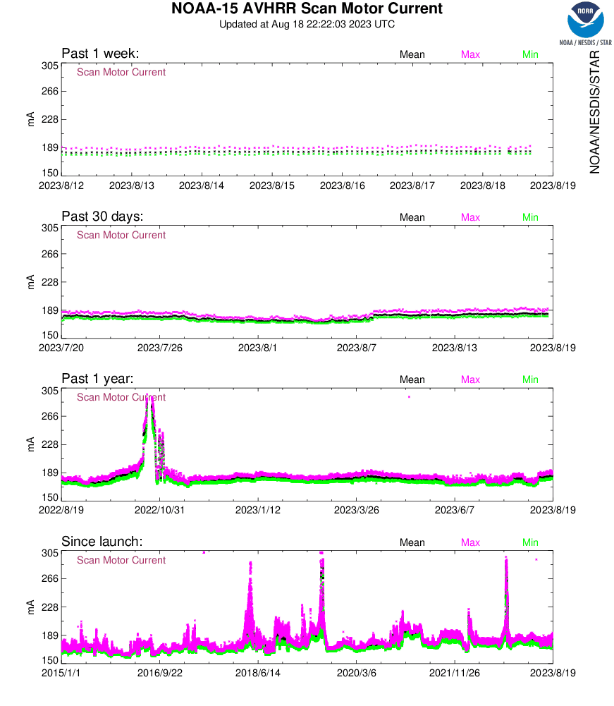
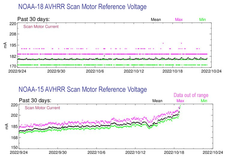
Looks like NOAA 15 AVHRR scan motor is heating up again, Causing some issues with scanning and affecting the APT and HRPT Imagery:

Example of Corrupted imagery Captured by Ed de Jong 08/28/2023

What follows below is an article from October 2022

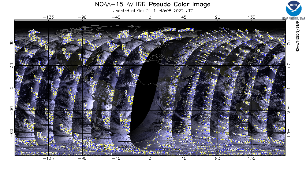
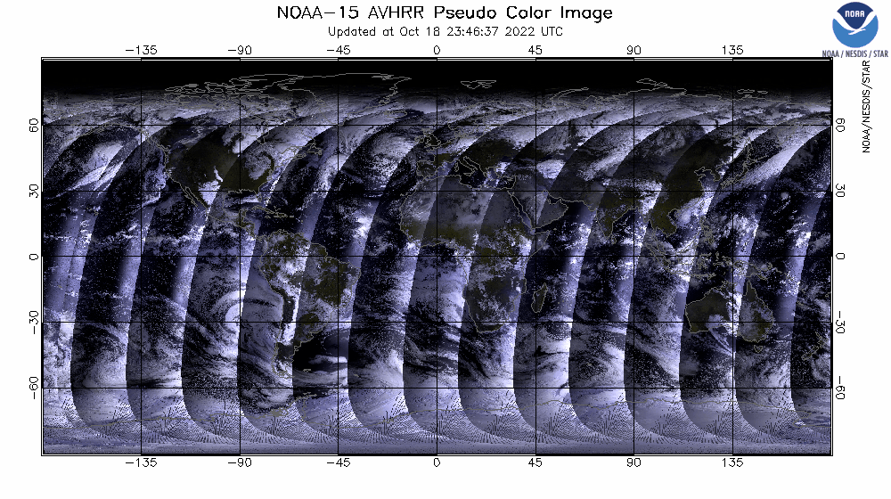
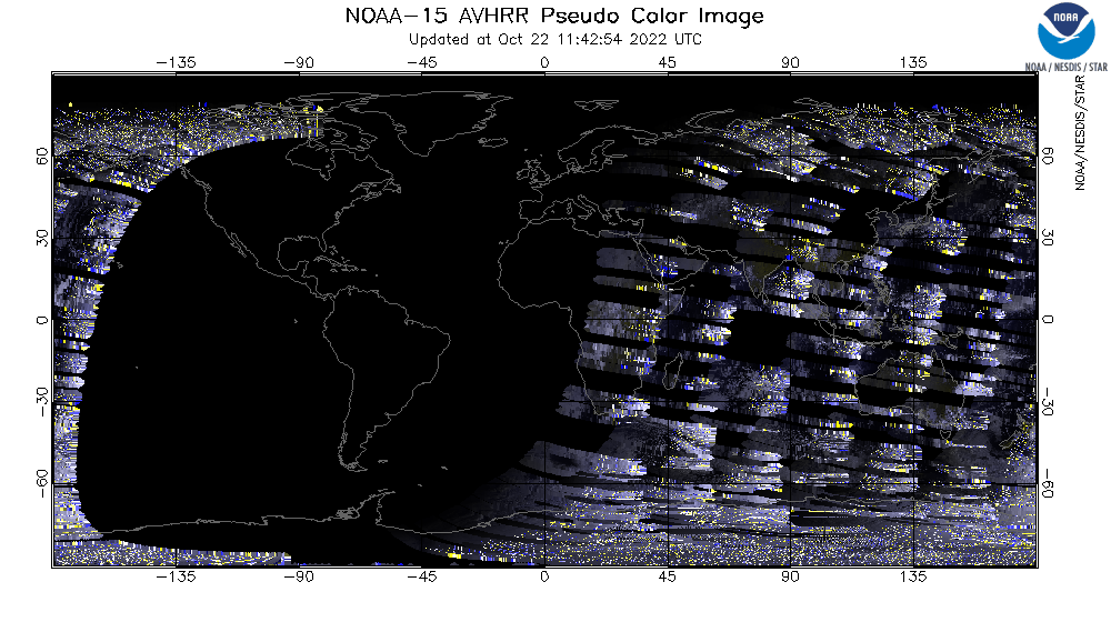
NOAA-15 AVHRR degraded image data.


RECOVERY!
Update 10/26/2022, Scan motor current draw has begun to drop
I have developed this technical diagram to better explain the complex issues on NOAA-15 AVHRR Scan Motor Current anomaly. Hope this clears things up a bit.

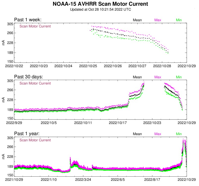
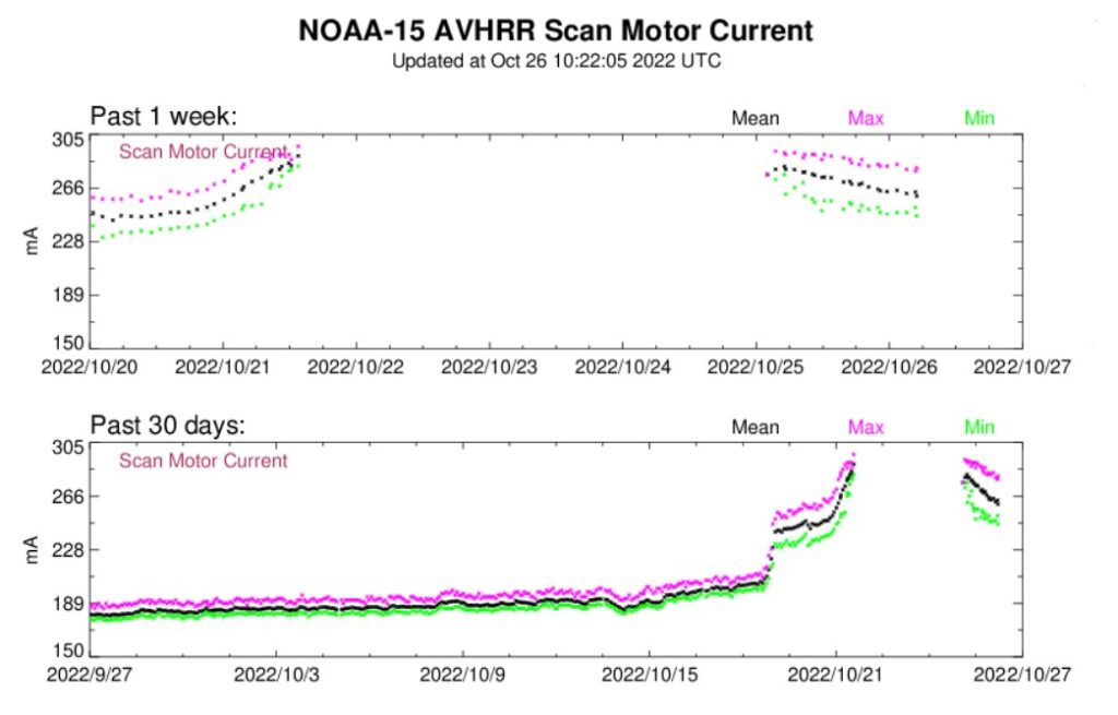
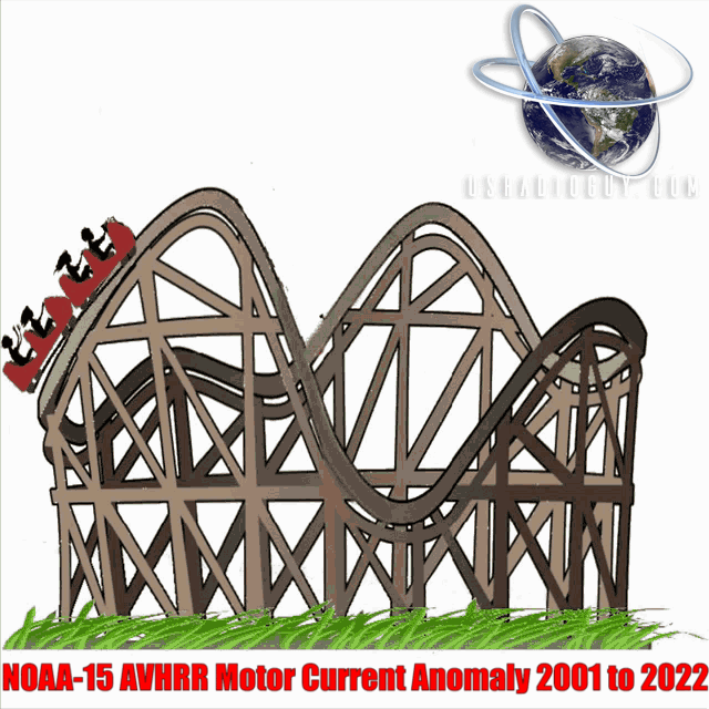
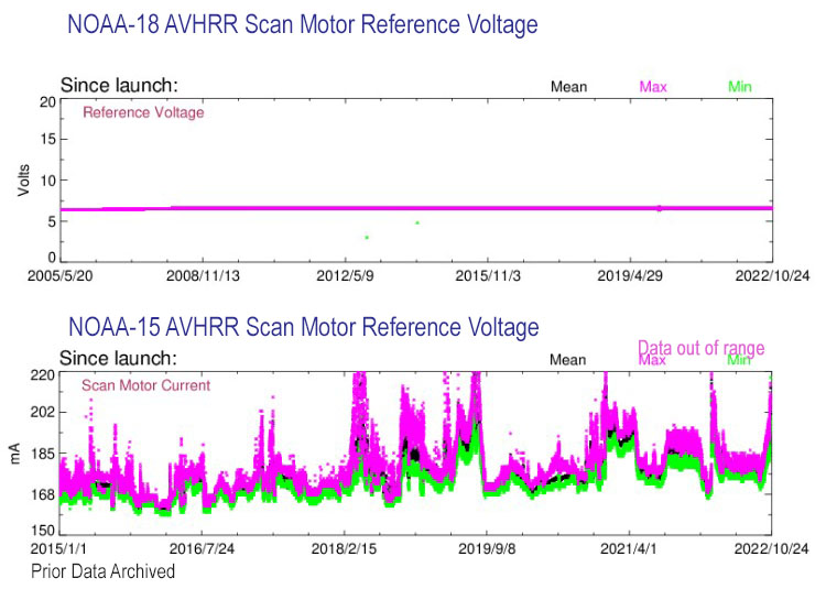
Starting on October 18th, 2022, NOAA-15 suffered an issue with its AVHRR Scan Motor. This is not the first time it has happened to NOAA-15. In fact, it has happened several times, AVHR scan motor current surges have caused issues with the AVHR since 2001. In 2015 the AVHR motor stopped entirely, then was restarted by ground controllers adjusting the voltages to the motor. Since 2015 the status of the AVHR on NOAA’s status page has been yellow (Operational with limitations (or Standby)).

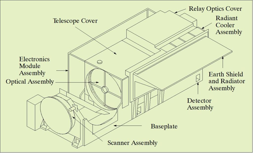
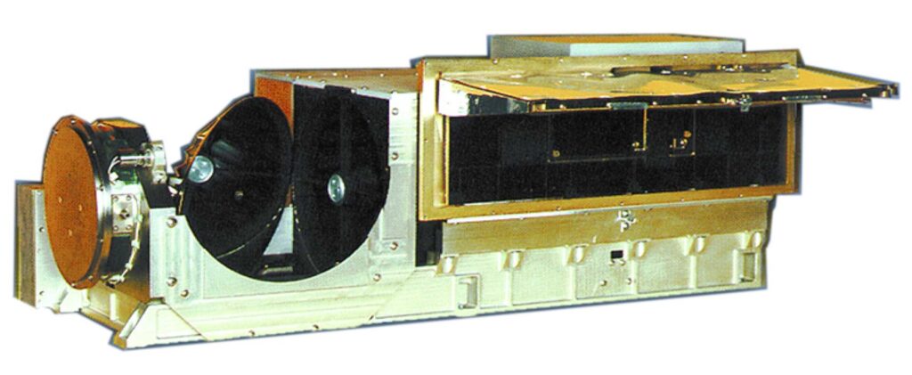
The Advanced Very High-Resolution Radiometer (AVHRR) is a cross-track scanning system with five spectral bands having a resolution of 1.1 km and a frequency of earth scans twice per day. A major AVHRR/3 improvement was the installation of a larger external sun shield to the scan motor housing on the NOAA satellites, to reduce sunlight impingement on the sensor and to stabilize its illumination and thermal regimes. But, After 20 plus years…this cycle of cold/hot and constant motor use takes its toll. The leading theory is that the lubricant used in the motor has degraded. The AVHRRs are designed to operate at an ambient temperature of 286–288 K. In past events the sensor was commanded to cool-down and warm-up again. Which seemed to have freed up the motor.

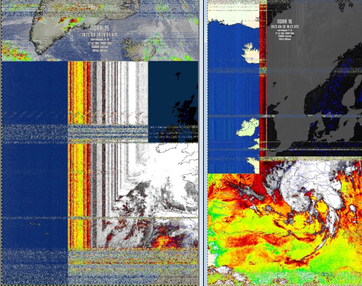
The image below clearly shows the effect of the AVHR scan motor stepping or stuttering. Engineers will attempt to reset the AVHR motor, BUT, this can only be done while the satellite is in the correct position for command and control facilities to receive and transmit commands to the satellite. (Twice a day for 18-25 minutes on average)

NOAA 15 Imagery received- showing the scan motor anomaly and it’s effect
October 21, 2022 AVHR issues clearly apparent
Running a script and animating a Global Area Coverage (GAC) data set -showing global coverage shows that the AVHR started this round of stepping on Oct 18th,2022
October 22, 2022…looking worse, possible command and control ordered restart of scan motor.
Brightness Temps are also affected.

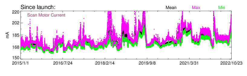
Scan Motor Current spikes seen in 2018 (the Last time the AVHR acted up) and the current-voltage spike in October 2022.

If the AVHR scan motor issue cannot be resolved, NOAA may decide to shut down the AVHR and thereby ending APT imagery. However, NOAA-15 HIRS and The Advanced Microwave Sounding Unit-A (AMSU-A) are still functioning and it can be expected that these will continue to be used by NOAA. AVHRR loss would probably not result in the total loss of the spacecraft.

As you can see, a comparison to NOAA-18 vs. NOAA 15 shows the issue quite well.

NOAA-15 has had issues with the AVHRR scan motor for quite some time.

Coincidentally, and not related to the scan motor issue, NOAA signed an agreement with Parsons Corporation to take over the On-Orbit operations of NOAA 15,18,19. I have an article on that here: NOAA 15,18,19 to transition to private On-orbit operations

There has been a lengthy history of AVHRR failure on board NOAA-15 –

On 10 July 2000, there was an apparent failure of the NOAA-15 AVHRR scan motor. HRPT and APT image data were missing through July 12, orbit 11250. On this orbit, AVHRR synchronization was restarted and HRPT and APT image data were temporarily resumed. AVHRR synchronization was again lost on 22 July on orbit 11395. Tests during December 2000 and January 2001 have shown that lowering the temperature of the instrument has restored a degree of stability. Beginning 20 March 2001, NOAA began to resynchronize the AVHRR once daily at 0730 UTC. The AVHRR has shown the ability to retain synchronization for longer periods with this daily reset. During the time of the resynchronization, there is a very brief disruption in all data in the HRPT transmission. When the AVHRR is in synchronization, usable images may be obtained. When the AVHRR synchronization is out of limits, images are unusable. HRPT transmitter will remain ON; the APT transmitter turned ON at 1611 UTC, 15 March 2001. At 1820 UTC, on 30 October 2000, the NOAA-15 AMSU-A Channel 14 failed and is no longer usable.

NOAA-15 AVHRR. The AVHRR/3 is a six-channel imaging radiometer that detects energy in the visible and IR portions of the electromagnetic spectrum. The instrument measures reflected
solar (visible and near-IR) energy and radiated thermal energy from land, sea, clouds,
and the intervening atmosphere. Scanning is accomplished by a continuously rotating scan mirror that is directly driven by a brushless DC motor. This six multispectral channel radiometer started its first operational flight on NOAA-15, which launched in May 1998.
NOAA-15 AVHRR

Post navigation

❮ Previous Post: NOAA 15,18,19 to transition to private On-orbit operations
Next Post: Himawari-8 to Himawari-9 Transition ❯

You may also like

Satellites
Satellite imagery reprojection method
April 13, 2023
Science
GOES-T mated to the payload adapter
January 29, 2022
Satellites
GOES-U, the 4th and Last of the GOES-R Series
March 26, 2024
Satellites
Invited to present at SSEC CMISS
August 28, 2020

Please, Help Support USRadioguy.com

If you like what I do please support me on Ko-fi, It really means a lot, every bit helps!

Hardware Humor Imagery Processing Interesting stuff you should know! Launch News Life News Product Review Satellites Science Software Space Weather Uncategorized VLOG

Alphabetical Listing of all Pages on site:

  • 36-Hour Imagery Processing script
  • 3D animation of realtime data
  • A PORTABLE WWII ERA “MORALE RADIO”
  • About Me
  • ADS-B Reception
  • Allsky Camera
  • AN/GRR-5 THE ANGRY 5
  • BD-71 Field Switch Board and EE-8B Field Telephones
  • Current GOES 16 & 18 False Color Satellite Imagery
  • Custom Color Lookup Table
  • Custom Imagery Scripts for GOES
  • Daily 3D view of Earth
  • Daily Global Composites
  • Decoding EWS-G1 or GOES-13
  • Drifting a geostationary satellite
  • DRONE FUN
  • Even the kitchen sink
  • GEO-RING COMPOSITES
  • GEO-SAT PI FRAME
  • Geo-stationary Satellite Imagery Reception
  • Global Weather Data
  • GOES 19&18 – Last 96 Hours of Imagery
  • GOES BAND IMAGERY
  • GOES GRB Reception
  • GOES receiving in Windows for SatDump
  • GOES-18 Preparing for a new satellite
  • GOES-R Series Multimedia Tour
  • GOES-U (19) Countdown to Launch
  • GOES16 A full year of received imagery
  • Ground Station Map
  • High Resolution Imagery
  • Home
  • House History
  • HRIT/EMWIN & GRB
  • HRPT Satellite Tracking and Capture
  • Hubble Space Telescope Data Processing
  • Inmarsat Decoding
  • Layering Fire and Hotspot Data on Meteor Sat Imagery
  • Layering Geo-Spatial Fire Data into Satellite Imagery
  • Mesoscale Imagery Defined
  • METEOR M2- Series
  • MODIS VIIRS Global Coverage
  • My Other Interests
  • NASA, NOAA, Military, GOVT dish, and tower stations.
  • National Hurricane Data
  • Newsletter terms & conditions
  • NOAA & Meteor APT and LRPT RECEPTION
  • Online Satellite Imagery and Information
  • Optimizing a WIFI Grid Antenna for Maximum Efficiency
  • ORBITAL DYNAMICS 101
  • Orbitron, Gpredict, and PSTRotator with new TLE format
  • PI Based Broadcastify Server
  • Pi Based Picture Frame
  • Presentations
  • Privacy Policy
  • Programming the PI for goestools operation
  • R-100/URR 1944 MORALE RADIO
  • RADIO SET SCR-284
  • Rare Captures
  • Receiving GOES 18,19 with goestools
  • Receiving GOES HRIT with SATDUMP
  • Receiving the Funcube Amateur Satellite
  • Satdump for Meteor and NOAA decoding
  • Satellite Finder
  • Satellite Frequencies
  • Satellite Ground Stations
  • Satellite Tracking
  • Security
  • SETEC Astronomy
  • Solar Power for PI
  • South America GOES 16
  • Space Weather
  • Stray Light Zone (SLZ)
  • Thanks!
  • The quest for True Color Imagery
  • Tried and Tested Hardware
  • Usradioguy Blogs
  • Usradioguy Merchandise
  • USRadioguy Newsletter
  • USRadioguy VLOGS
  • USRADIOGUY Youtube Page
  • VIBRATOR CONVERSION MODULE
  • Viterbi, R/S Errors, Packets
  • VS-3 VIBRATOR CONVERSION
  • What is RTL-SDR?
  • WWII Audio Page
  • WWII K-24 Aerial Camera
  • WWII RADIO
  • WxtoImg Fix
  • Your very Own Weather Satellite
  • Zombie Satellites

Hardware Humor Imagery Processing Interesting stuff you should know! Launch News Life News Product Review Satellites Science Software Space Weather Uncategorized VLOG

Satellite And Weather Related Feeds

  • CIMSS Satellite Blog
  • USRadioguy.com
  • wildfires
  • NASA Earth Observatory
  • SPC Particularly Dangerous Situation (PDS) Tornado/Severe Thunderstorm Watch
  • satellites
  • Satellites News -- ScienceDaily
  • Satellite Liaison Blog
Resuspended volcanic ash from the 1980 eruptions of Mount St. Helens
Outbreak of tornadoes across North Dakota
Post-Tropical Cyclone Kiko north of Hawai’i
SatDump 2.0
SatDump 2.0
WXtoIMG: A Legacy in Weather Satellite Decoding
NOAA 15 and 19 Decommisioning
The fire cycle
New NOAA tool can predict potential wildfires on an hourly basis
Unmasking the complicated chemistry of wildfire smoke: What's in it?
By the Warm Light of the Moon
Arctic Sea Ice Ties for 10th-Lowest on Record
Cooper Creek Replenishes Lake Eyre
SPC PDS Severe Thunderstorm Watch 399
Experts to preview launch of historic NOAA space weather satellite observatory
Five historically huge solar events
65 years since the world’s first weather satellite
Hubble just revealed the fiery heart of the Cigar Galaxy
This rare white dwarf looks normal, until Hubble shows its explosive secret
A weirdly shaped telescope could finally find Earth 2. 0
Hurricane Erin: East Coast Impacts and Extratropical Transition
Hurricane Erin (2025) Rapid Intensification
August 2025 Milwaukee Flooding
  • Facebook Geo Stationary Satellites
  • Usradioguy Facebook
  • Instagram
  • Reddit
  • Github
  • Linkedin

Copyright © 2025 USRadioguy.com - All Rights Reserved. All material protected by Fair Use Section 107 of the Copyright Act. This site is Verified and Secured with 256 bit SSL encryption

Help Fund USRadioguy.com

USRadioguy Needs Your Help