Skip to content
USRADIOGUY

USRadioguy.com

Welcome to USRadioguy.com – Unlocking the Potential of Software Defined Radio

  • Home
    • Home of USRadioguy
    • USRadioguy Newsletter
    • Tried and Tested Hardware
    • What is RTL-SDR?
    • Global Weather Data
  • Satellite Reception
    • Geo Stationary Satellites
      • Geo-stationary Satellite Imagery Reception
      • GOESTOOLS on the PI
      • Update Goestools for GOES 18,19
      • Receiving GOES with SatDump CLI Mode
      • GOES receiving in Windows for SatDump GUI
      • Decoding EWS-G1/EWS-G2
      • GOES GRB Reception WIP
      • Optimizing a WIFI Grid Antenna for Maximum Efficiency
    • APT Satellites
      • APT RECEPTION
      • Satdump for Meteor and NOAA decoding
      • METEOR M2- Series
      • WxtoImg Fix
      • Converting to new TLE format
      • Layering Fire and Hotspot Data on Meteor Sat Imagery
      • HRPT Satellite Tracking and Capture
    • Receiving Other Satellites
      • Inmarsat Decoding
      • Receiving the Funcube Amateur Satellite
    • User Maps and Dish Pointers
      • Satellite Dish Pointer
      • User Global Ground Station Maps
      • Usermap rendered with Cesium
      • Global Map of Govt Dish Stations
    • Satellite Details & Information
      • ORBITAL DYNAMICS 101
      • HRIT/EMWIN & GRB Defined
      • Mesoscale Imagery Defined
      • Viterbi, R/S Errors, Packets
      • GOES BAND IMAGERY
      • Stray Light Zone (SLZ)
      • Drifting a geostationary satellite
      • GOES-R Series Multimedia Tour
      • Online Satellite Imagery and Information
      • Satellite Frequencies
      • Solar and Space Weather
  • Satellite Imagery
    • IMAGERY- Current GOES East & West HRIT Satellite Imagery
    • IMAGERY- GOES 16&18 – Past 96 Hours of Imagery
    • High Resolution Imagery
    • Daily 3D view of Earth
    • NOAA APT Satellite imagery
    • PlanetMaker
    • GOES16 A full year of received imagery
  • Imagery Processing
    • Custom Color Lookup Table & Gradients
    • GOES-R Custom Imagery Scripts
    • Global geo-ring composites
    • MODIS VIIRS Global Coverage
    • 3D Satellite Tracking
    • The quest for True Color Imagery
    • 3D animation of realtime data
    • Layering Geo-Spatial Fire Data into Satellite Imagery
    • Orbital dynamics and the Moon
    • National Hurricane Data
  • News, VLOGS & BLOGS
    • News & USRadioguy Blogs
    • USRadioguy VLOGS
  • Project Lab
    • Orbital Information and Visualizations
      • Enhanced Planet Earth
      • Satellites in Orbit
      • Solar System
      • Objects in Orbit
    • Current Station Weather
      • Current Groundstation Weather
      • Global Weather Data
      • Space Weather
    • WWII RADIO
      • WWII K-24 Aerial Camera
      • WWII RADIO
      • RADIO SET SCR-284
      • VS-3 VIBRATOR CONVERSION
      • VIBRATOR CONVERSION MODULE
      • BD-71 Field Switch Board and EE-8B Field Telephones
      • R-100/URR 1944 MORALE RADIO
      • A PORTABLE WWII ERA “MORALE RADIO”
      • AN/GRR-5 THE ANGRY 5
      • WWII Audio Page
    • Raspberry Pi Projects
      • ADS-B Reception
      • Allsky Camera
      • Pi Based Picture Frame
      • PI Based Broadcastify Server
      • Solar Power for PI
    • Hubble Space Telescope Data Processing
    • Zombie Satellites
    • DRONES
  • About Me
    • About Usradioguy
      • SETEC Astronomy
    • Tried and Tested Hardware
    • Rare Captures
    • My Other Interests
    • Presentations
    • Merchandise
    • Privacy Policy
  • Home
  • Satellites
  • Vitality GOES

Vitality GOES

Posted on June 9, 2025June 9, 2025 By Carl
Satellites, Software

Loading

Vitality GOES- A tool to work with imagery and data created by goestools and/or Satdump

Jamie Vital has built a Web App for showcasing Geostationary Weather Satellite Data. The software is designed to display text and images received from GOES satellites via goestools and satdump.

UPDATE: 3/08/2025

The latest version as of this writing is Vitality GOES – 1.5.3 with several new features! The update has something for many of us, no matter where in the world we are.

USRadioguy Theme
USRadioguy Theme

What’s new in Vitality GOES 1.5.3

  • added example configs for SatDump 1.2.1 composite names, and its new L2/non-cmip processing. You must be on the yet-to-be-released SatDump 1.2.1, or the latest nightly, for the new configs to work. Note: there is no code change here – if you only want to add SatDump’s new composites to Vitality GOES, you only need to look at the new example configs.
  • Added support for Special Weather Statements.
  • Fixed all SatDump example configs to work on Linux.
  • Fixed multiple bugs in displaying the current weather. However, there is more to do here!
  • Fix a few bugs in the video rendering scripts
  • Added support for displaying timelapse videos from a URL instead of the videos/ folder

You can get the newest version from https://github.com/JVital2013/vitality-goes. Note this version requires updating your config files as well At least the change gives you more flexibility and the ability to support more satellites.

SatDump is supported for Windows/Linux! This makes it so you can run the entire stack (SDR -> SatDump -> Vitality GOES) all on one Windows Host, which could be helpful for some folks. Jamie put together a video at https://www.youtube.com/watch?v=XMDAiUjzkhw that goes over how to throw together a setup that can be evolved into a full, Windows-based ground station. I think one of the great features of this app is the ability to sort and make useful the thousands of EMWIN images, text, forecasts, radar, etc. that can be received.
One newer feature is an “Alert” that appears at the top of the local weather page that lets the user know if there are any warnings/watches or other weather emergencies.

Jamie Vital has built a Web App for showcasing Geostationary Weather Satellite Data. The software is designed to display text and images received from GOES satellites via goestools.

The author has written a great description of the software package he created and has it over on his github page which you can find here: https://github.com/JVital2013/vitality-goes


Youtube preview of the software- More videos and Images here: https://github.com/JVital2013/vitality-goes/wiki/Screenshots-and-Videos

What does Vitality GOES do?

Vitality GOES makes data from the GOES HRIT/EMWIN feed easily accessible, through a web browser, from anywhere on your local network. Even if the internet goes down, people on your local LAN can still access real-time weather information.

Vitality GOES has the following features:

  • Once set up by the ground station technician (you!), Vitality GOES is easily usable by anyone with no knowledge of radio, satellites, or programming.
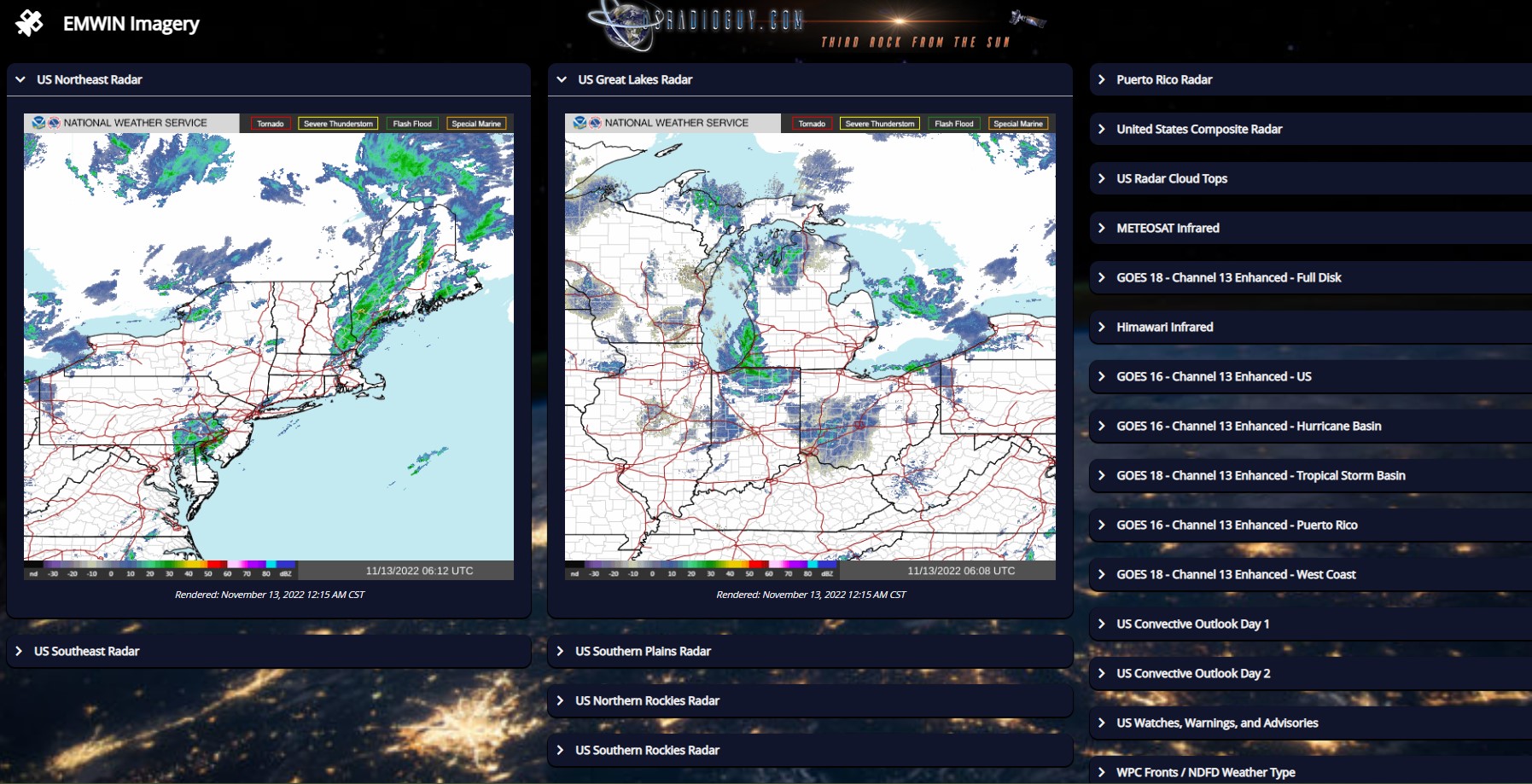
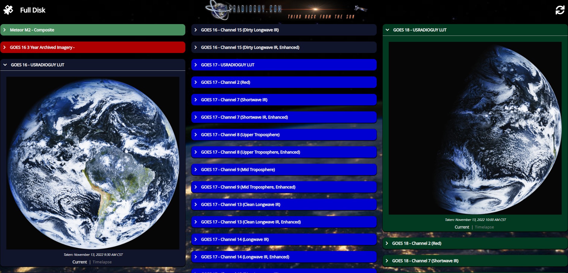
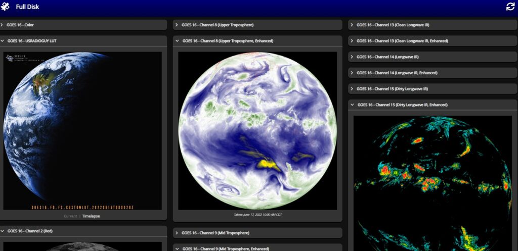
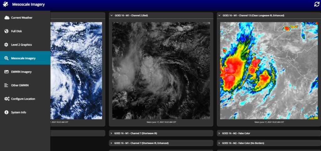
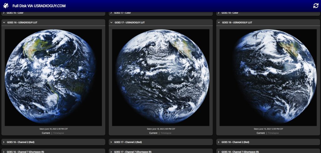
  • It presents all full-disk, Level 2 products, and mesoscale imagery in a user-friendly and easily navigatable way.
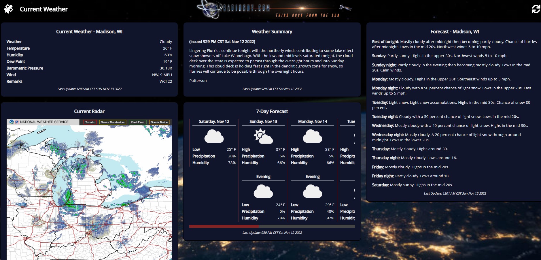
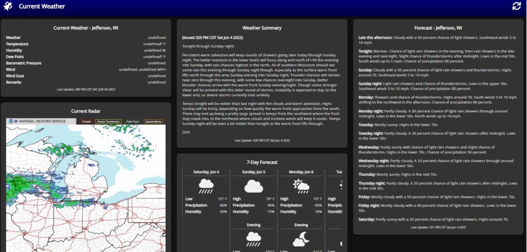
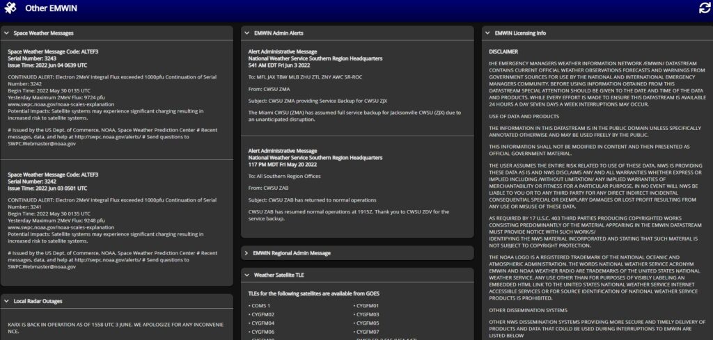
  • Pertinent EMWIN data (which includes current weather conditions, forecasts, watches, and warnings) are presented to the user in a way that is appealing and easy to read. There is no need to parse through data for other locations: your configured location’s data is the only thing you’re shown. For a write-up on the EMWIN data Vitality GOES pulls and how it’s used, see here.
  • It is able to monitor the status of the underlying goestools stack, including systems temps, error correction rates, and packet drop rates.

How does it work?

The following diagram shows how data flows from a GOES satellite, through Vitality GOES, and to the end-users:

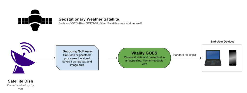
To put it simply: goestools and secondary scripts dump data to a folder on the ground station computer. From there, Vitality GOES reads the data and presents it to the user on their device across the local network.


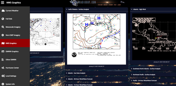
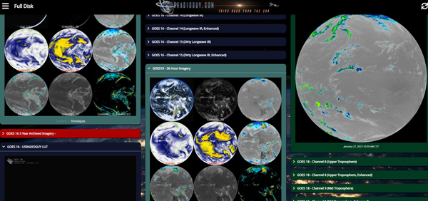
A few examples running on my system while I was testing it.


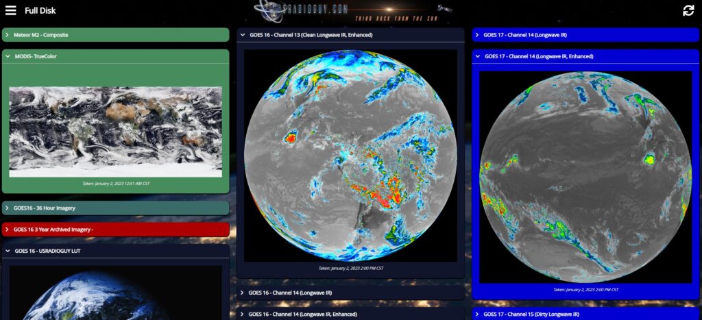
Added the ability to display my composite Meteor Imagery

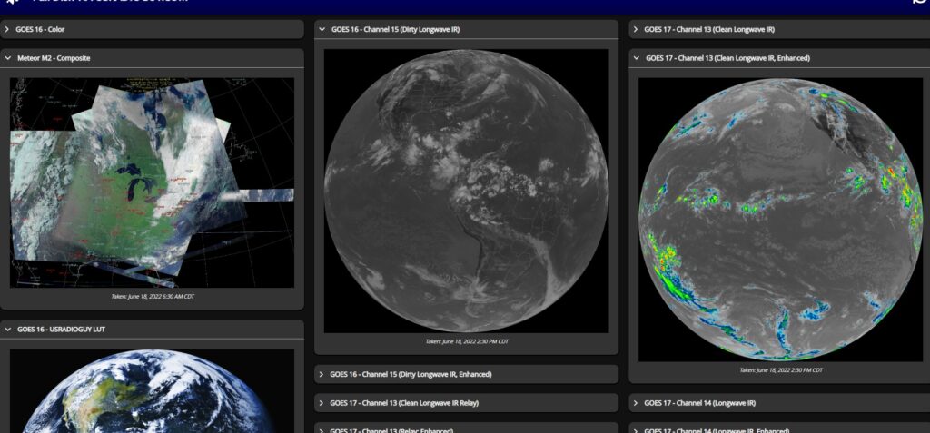
And the ability to display GOES 16, 17, and 18 (18 is from last weeks interleave tests)


The software is highly configurable and with some tweaks to the css, script, you can really customize this to your own preferences as I did, shown below:

Showing the Customization Possible
Tags: Satellite Imagery software

Post navigation

❮ Previous Post: Decommissioning NOAA-18
Next Post: End Of Life for NOAA 15 and 19?….not so fast… ❯

You may also like

News
Mixed results for NOAA Funding
March 11, 2024
Satellites
GOES-U Launch Preparations
June 24, 2024
Launch News
GOES-U Launch Day
June 25, 2024
Life
Geo Magnetic Storm 04.23.2023
April 28, 2023

Please, Help Support USRadioguy.com

If you like what I do please support me on Ko-fi, It really means a lot, every bit helps!

Hardware Humor Imagery Processing Interesting stuff you should know! Launch News Life News Product Review Satellites Science Software Space Weather Uncategorized VLOG

Alphabetical Listing of all Pages on site:

  • 36-Hour Imagery Processing script
  • 3D animation of realtime data
  • A PORTABLE WWII ERA “MORALE RADIO”
  • About Me
  • ADS-B Reception
  • Allsky Camera
  • AN/GRR-5 THE ANGRY 5
  • BD-71 Field Switch Board and EE-8B Field Telephones
  • Current GOES 16 & 18 False Color Satellite Imagery
  • Custom Color Lookup Table
  • Custom Imagery Scripts for GOES
  • Daily 3D view of Earth
  • Daily Global Composites
  • Decoding EWS-G1 or GOES-13
  • Drifting a geostationary satellite
  • DRONE FUN
  • Even the kitchen sink
  • GEO-RING COMPOSITES
  • GEO-SAT PI FRAME
  • Geo-stationary Satellite Imagery Reception
  • Global Weather Data
  • GOES 19&18 – Last 96 Hours of Imagery
  • GOES BAND IMAGERY
  • GOES GRB Reception
  • GOES receiving in Windows for SatDump
  • GOES-18 Preparing for a new satellite
  • GOES-R Series Multimedia Tour
  • GOES-U (19) Countdown to Launch
  • GOES16 A full year of received imagery
  • Ground Station Map
  • High Resolution Imagery
  • Home
  • House History
  • HRIT/EMWIN & GRB
  • HRPT Satellite Tracking and Capture
  • Hubble Space Telescope Data Processing
  • Inmarsat Decoding
  • Layering Fire and Hotspot Data on Meteor Sat Imagery
  • Layering Geo-Spatial Fire Data into Satellite Imagery
  • Mesoscale Imagery Defined
  • METEOR M2- Series
  • MODIS VIIRS Global Coverage
  • My Other Interests
  • NASA, NOAA, Military, GOVT dish, and tower stations.
  • National Hurricane Data
  • Newsletter terms & conditions
  • NOAA & Meteor APT and LRPT RECEPTION
  • Online Satellite Imagery and Information
  • Optimizing a WIFI Grid Antenna for Maximum Efficiency
  • ORBITAL DYNAMICS 101
  • Orbitron, Gpredict, and PSTRotator with new TLE format
  • PI Based Broadcastify Server
  • Pi Based Picture Frame
  • Presentations
  • Privacy Policy
  • Programming the PI for goestools operation
  • R-100/URR 1944 MORALE RADIO
  • RADIO SET SCR-284
  • Rare Captures
  • Receiving GOES 18,19 with goestools
  • Receiving GOES HRIT with SATDUMP
  • Receiving the Funcube Amateur Satellite
  • Satdump for Meteor and NOAA decoding
  • Satellite Finder
  • Satellite Frequencies
  • Satellite Ground Stations
  • Satellite Tracking
  • Security
  • SETEC Astronomy
  • Solar Power for PI
  • South America GOES 16
  • Space Weather
  • Stray Light Zone (SLZ)
  • Thanks!
  • The quest for True Color Imagery
  • Tried and Tested Hardware
  • Usradioguy Blogs
  • Usradioguy Merchandise
  • USRadioguy Newsletter
  • USRadioguy VLOGS
  • USRADIOGUY Youtube Page
  • VIBRATOR CONVERSION MODULE
  • Viterbi, R/S Errors, Packets
  • VS-3 VIBRATOR CONVERSION
  • What is RTL-SDR?
  • WWII Audio Page
  • WWII K-24 Aerial Camera
  • WWII RADIO
  • WxtoImg Fix
  • Zombie Satellites

Hardware Humor Imagery Processing Interesting stuff you should know! Launch News Life News Product Review Satellites Science Software Space Weather Uncategorized VLOG

Satellite And Weather Related Feeds

  • CIMSS Satellite Blog
  • USRadioguy.com
  • wildfires
  • NASA Earth Observatory
  • SPC Particularly Dangerous Situation (PDS) Tornado/Severe Thunderstorm Watch
  • satellites
  • Satellites News -- ScienceDaily
  • Satellite Liaison Blog
Wildfire in Ontario produces a large pyrocumulonimbus cloud
American Samoa’s Wettest Year Gets Wetter
Deadly flash flooding in Ruidoso, New Mexico
Global cloud layers on your Devices
End Of Life for NOAA 15 and 19?….not so fast…
Vitality GOES
Vitality GOES
The fire cycle
Unmasking the complicated chemistry of wildfire smoke: What's in it?
NOAA unveils powerful convergence of AI and science with revolutionary Next-Generation Fire System technology
The Salty Lake of Gas Hure
Greenland’s Bejeweled Ice Sheet
Manitoba Burning
Manitoba Burning
SPC PDS Severe Thunderstorm Watch 399
Five historically huge solar events
65 years since the world’s first weather satellite
Investing in America: NOAA's Science, Service and Stewardship in Action
Earth’s weather satellites just spent 10 years watching Venus — here’s what they found
Record-breaking 10-billion-year radio halo just rewrote the universe’s origin story
Massive thread of hot gas found linking galaxies — and it’s 10 times the mass of the Milky Way
The Need for Speed: OCTANE Cloud-Top Winds at SPC
Summer Storms, Flooding Target Mid-Atlantic
Southwest Thunderstorms – Late June 2025
  • Facebook Geo Stationary Satellites
  • Usradioguy Facebook
  • Instagram
  • Reddit
  • Github
  • Linkedin

Copyright © 2025 USRadioguy.com - All Rights Reserved. All material protected by Fair Use Section 107 of the Copyright Act. This site is Verified and Secured with 256 bit SSL encryption