Skip to content
USRADIOGUY

USRadioguy.com

Welcome to USRadioguy.com – Unlocking the Potential of Software Defined Radio

  • Home
    • Home of USRadioguy
    • Tried and Tested Hardware
    • USRadioguy Newsletter
    • What is RTL-SDR?
    • Global Weather Data
  • Satellite Reception
    • Geo Stationary Satellites
      • Geo-stationary Satellite Imagery Reception
      • GOESTOOLS on the PI
      • Update Goestools for GOES 18,19
      • Receiving GOES with SatDump CLI Mode
      • GOES receiving in Windows for SatDump GUI
      • Decoding EWS-G1/EWS-G2
      • GOES GRB Reception WIP
      • Optimizing a WIFI Grid Antenna for Maximum Efficiency
    • APT Satellites
      • APT RECEPTION
      • Satdump for Meteor and NOAA decoding
      • METEOR M2- Series
      • WxtoImg Fix
      • Converting to new TLE format
      • Layering Fire and Hotspot Data on Meteor Sat Imagery
      • HRPT Satellite Tracking and Capture
    • Receiving Other Satellites
      • Inmarsat Decoding
      • Receiving the Funcube Amateur Satellite
    • User Maps and Dish Pointers
      • Satellite Dish Pointer
      • User Global Ground Station Maps
      • Usermap rendered with Cesium
      • Global Map of Govt Dish Stations
    • Satellite Details & Information
      • ORBITAL DYNAMICS 101
      • HRIT/EMWIN & GRB Defined
      • Mesoscale Imagery Defined
      • Viterbi, R/S Errors, Packets
      • GOES BAND IMAGERY
      • Stray Light Zone (SLZ)
      • Drifting a geostationary satellite
      • GOES-R Series Multimedia Tour
      • Online Satellite Imagery and Information
      • Satellite Frequencies
      • Solar and Space Weather
  • Satellite Imagery
    • IMAGERY- Current GOES East & West HRIT Satellite Imagery
    • IMAGERY- GOES 16&18 – Past 96 Hours of Imagery
    • High Resolution Imagery
    • Daily 3D view of Earth
    • PlanetMaker
    • GOES16 A full year of received imagery
  • Imagery Processing
    • Custom Color Lookup Table & Gradients
    • GOES-R Custom Imagery Scripts
    • Global geo-ring composites
    • MODIS VIIRS Global Coverage
    • 3D Satellite Tracking
    • The quest for True Color Imagery
    • 3D animation of realtime data
    • Layering Geo-Spatial Fire Data into Satellite Imagery
    • Orbital dynamics and the Moon
    • National Hurricane Data
  • News, VLOGS & BLOGS
    • News & USRadioguy Blogs
    • USRadioguy VLOGS
  • Project Lab
    • Orbital Information and Visualizations
      • Enhanced Planet Earth
      • Satellites in Orbit
      • Solar System
      • Objects in Orbit
    • Current Station Weather
      • Current Groundstation Weather
      • Global Weather Data
      • Space Weather
    • WWII RADIO
      • WWII K-24 Aerial Camera
      • WWII RADIO
      • RADIO SET SCR-284
      • VS-3 VIBRATOR CONVERSION
      • VIBRATOR CONVERSION MODULE
      • BD-71 Field Switch Board and EE-8B Field Telephones
      • R-100/URR 1944 MORALE RADIO
      • A PORTABLE WWII ERA “MORALE RADIO”
      • AN/GRR-5 THE ANGRY 5
      • WWII Audio Page
    • Raspberry Pi Projects
      • ADS-B Reception
      • Allsky Camera
      • Pi Based Picture Frame
      • PI Based Broadcastify Server
      • Solar Power for PI
    • Your very Own Weather Satellite
    • Hubble Space Telescope Data Processing
    • Zombie Satellites
    • DRONES
  • About Me
    • About Usradioguy
      • SETEC Astronomy
    • Tried and Tested Hardware
    • Rare Captures
    • My Other Interests
    • Presentations
    • Merchandise
    • Privacy Policy
  • Home
  • Usradioguy Blogs
  • Satellites
  • Page 7

Category: Satellites

GOES-T Launch Photos

Posted on March 2, 2022March 2, 2022 By Carl
GOES-T Launch Photos
Satellites, Science

Loading

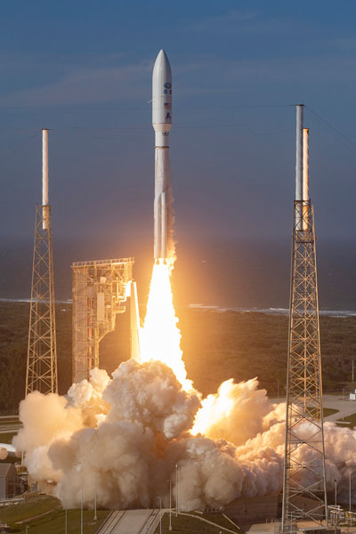
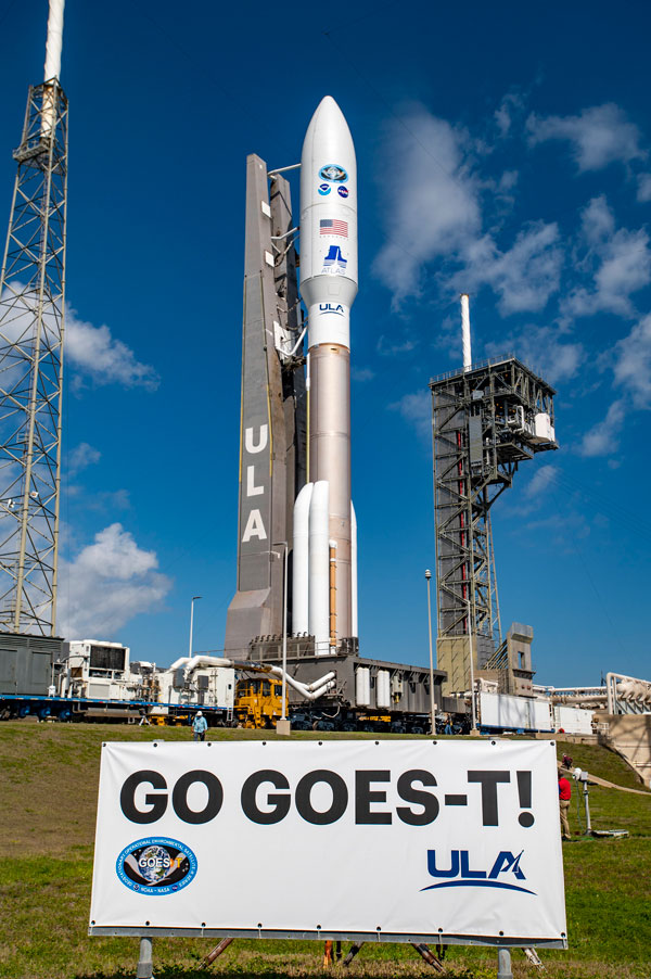
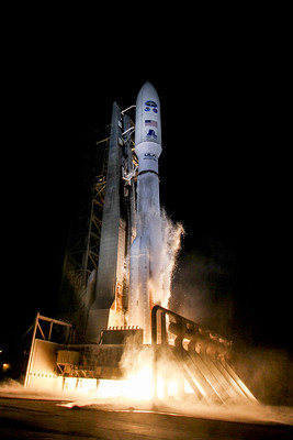
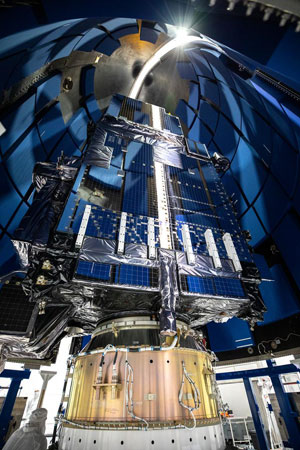
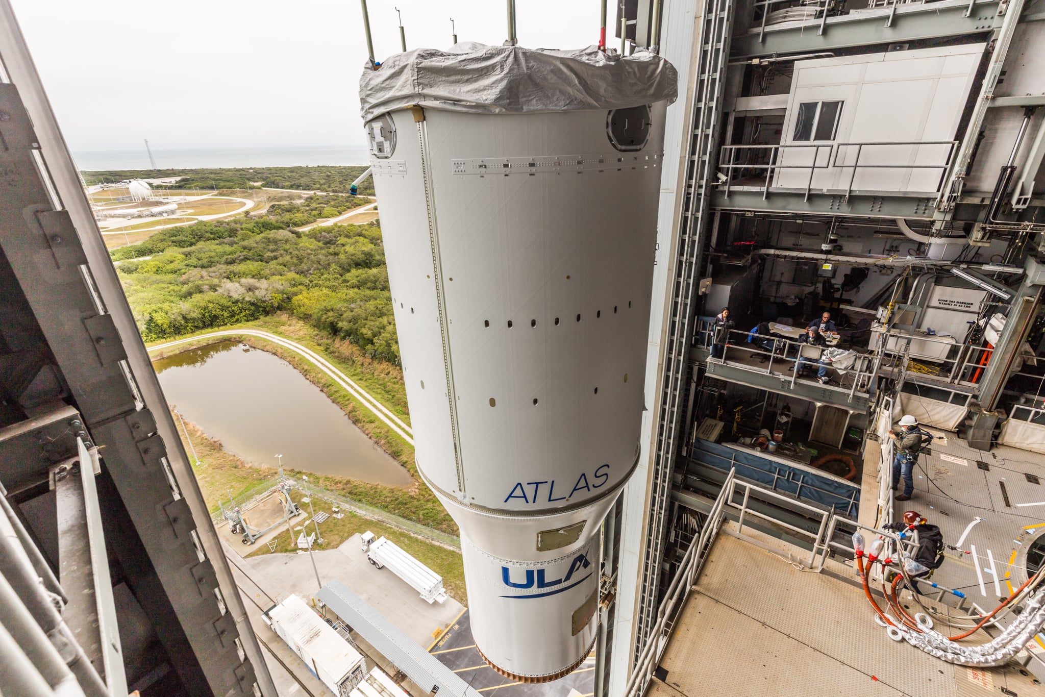
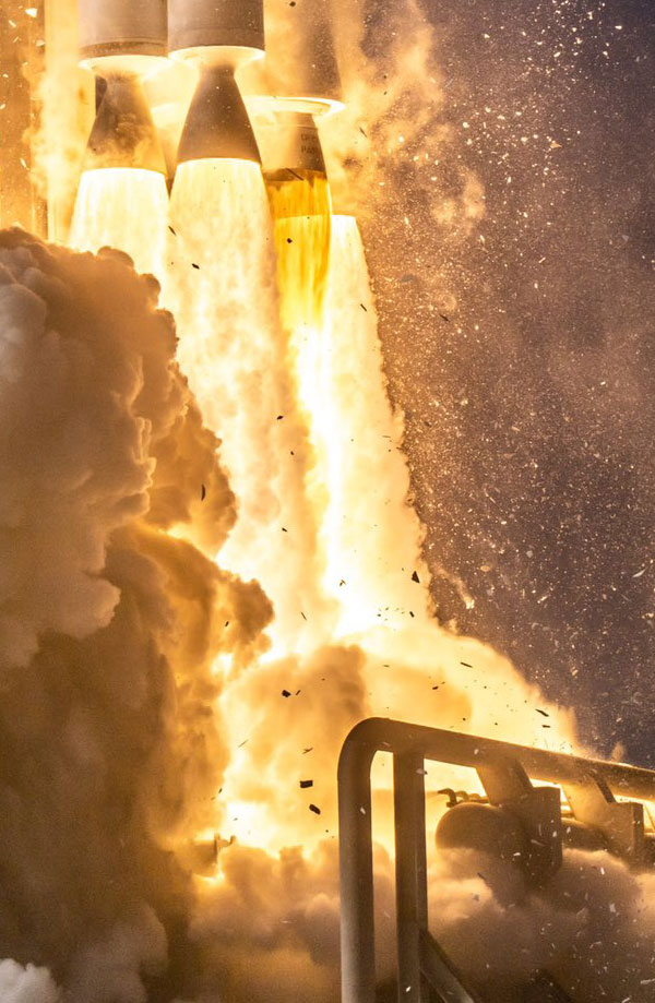
Photographer Nicholas D’Allesandro graciously allowed me to share a few of his AMAZING launch photos. Also included are a few press photo’s from NASA, NOAA, and United Launch Alliance. Preview in new tab The Last view of GOES-T ~ SPACECRAFT SEPERATION!T+plus 3 hours, 32 minutes, 55 seconds.

GOES-T Launch a success!

Posted on March 1, 2022March 1, 2022 By Carl
GOES-T Launch a success!
Satellites, Science

Loading

GOES-T, soon to be GOES-18, was successfully launched on March 1, 2022, at 4:38 p.m. EST from Space Launch Complex 41 at Cape Canaveral Air Force Station, Florida aboard an Atlas V 541 rocket. It was United Launch Alliance’s 149th mission, the 38th for Launch Services Program, and the 92nd launch of Atlas V. The Atlas … Delve Deeper “GOES-T Launch a success!” »

GOES-T Roll Out and Fueling

Posted on February 28, 2022February 28, 2022 By Carl
GOES-T Roll Out and Fueling
Satellites, Science

Loading

GOES-T on the Launchpad After Rollout GOES-T was rolled out to the launchpad from the ULA Vertical Integration Facility (VIF) on Feb. 28, 2022. Photos by United Launch Alliance Atlas RP-1 Loading Begins Fueling of the Atlas V first stage is underway at Cape Canaveral’s Space Launch Complex-41. The launch team is pumping 25,000 gallons … Delve Deeper “GOES-T Roll Out and Fueling” »

GOES-T Launch COUNTDOWN

Posted on February 26, 2022March 1, 2022 By Carl
GOES-T Launch COUNTDOWN
Satellites, Science

Loading

ATLAS V TO LAUNCH GOES-T Atlas V GOES-T Mission Profile A United Launch Alliance (ULA) Atlas V 541 rocket passed the Launch Readiness Review on Feb 26th, and will launch Geostationary Operational Environmental Satellites (GOES) –T mission for NOAA, NASA and NASA’s Launch Services Program (LSP). The launch is planned for March 1st from Space … Delve Deeper “GOES-T Launch COUNTDOWN” »

GOES-T Mated to Atlas-V

Posted on February 18, 2022February 18, 2022 By Carl
GOES-T Mated to Atlas-V
Satellites, Science

Loading

G’Day Mate – GOES-T Mated to Atlas-V Thursday and Friday, February 17 and 18 marked the transport from the Aerotech Building to the Verticle Launch Assembly platform of NOAA’s GOES-T spacecraft. GOES-T was transported to the VLA aboard United Launch Alliance’s 72 wheeled spacecraft transporter. The spacecraft, encapsulated in the rocket’s 17.7-foot (5.4-meter) out-of-autoclave (OoA) … Delve Deeper “GOES-T Mated to Atlas-V” »

GOES T Launch Dynamics

Posted on February 14, 2022February 14, 2022 By Carl
GOES T Launch Dynamics
Satellites, Science

Loading

MISSION OVERVIEW A United Launch Alliance (ULA) Atlas V 541 rocket will deliver the National Oceanic and Atmospheric Administration (NOAA) GOES-T spacecraft to an optimized geosynchronous transfer orbit. The optimized orbit places GOES-T closer to its final destination thereby conserving the satellite’s fuel supply for longer mission life. The mission is conducted in collaboration with … Delve Deeper “GOES T Launch Dynamics” »

GOES-T Encapsulated inside payload fairings

Posted on February 11, 2022February 11, 2022 By Carl
GOES-T Encapsulated inside payload fairings
Satellites, Science

Loading

Payload Encapsulation The United Launch Alliance Atlas V payload fairings are being secured around NOAA’s Geostationary Operational Environmental Satellite-T (GOES-T) inside the Astrotech Space Operations facility in Titusville, Florida. The payload fairing (PLF) provides a controlled, safe environment for spacecraft during ascent. This will be the last view of GOES-T here on earth! Photo credit: … Delve Deeper “GOES-T Encapsulated inside payload fairings” »

Atlas V assembled to launch GOES-T

Posted on February 7, 2022February 7, 2022 By Carl
Atlas V assembled to launch GOES-T
Satellites, Science

Loading

Atlas V 541 rocket Assembly United Launch Alliance (ULA) technicians have assembled the Atlas V 541 rocket to launch the National Oceanic and Atmospheric Administration’s (NOAA’s) Geostationary Operational Environmental Satellite (GOES)-T spacecraft. Assembly of the rocket, designated AV-095, began on Jan. 31, 2022, The 107-foot (33-meter) long first stage was delivered to the VIF, hoisted … Delve Deeper “Atlas V assembled to launch GOES-T” »

Mapping Ground Stations

Posted on February 6, 2022November 4, 2024 By Carl
Mapping Ground Stations
Life, Satellites, Science

Loading

It’s a small world after all…. Thinking of all the people from all around the world I have met through this nerdy hobby, and all the various countries they come from, I decided to try and map them out, on a global basis. There are lots and lots of sites that allow you to create … Delve Deeper “Mapping Ground Stations” »

GOES-T Encapsulation

Posted on February 5, 2022September 30, 2024 By Carl
GOES-T  Encapsulation
Satellites, Science

Loading

Preparing GOES-T for Encapsulation February 4, 2022. At Astrotech Space Operations facility in Titusville, Florida, technicians are now moving NOAA’s Geostationary Operational Environmental Satellite-T (GOES-T). The spacecraft is being prepared for encapsulation inside its protective payload fairings.  Photo credit: NASA/Kim Shiflett GOES-T is scheduled to launch on March 1, 2022, atop a United Launch Alliance … Delve Deeper “GOES-T Encapsulation” »

Posts pagination

Previous 1 … 6 7 8 9 Next

Please, Help Support USRadioguy.com

If you like what I do please support me on Ko-fi, It really means a lot, every bit helps!

Hardware Humor Imagery Processing Interesting stuff you should know! Launch News Life News Product Review Satellites Science Software Space Weather Uncategorized VLOG

Alphabetical Listing of all Pages on site:

  • 36-Hour Imagery Processing script
  • 3D animation of realtime data
  • A PORTABLE WWII ERA “MORALE RADIO”
  • About Me
  • ADS-B Reception
  • Allsky Camera
  • AN/GRR-5 THE ANGRY 5
  • BD-71 Field Switch Board and EE-8B Field Telephones
  • Current GOES 16 & 18 False Color Satellite Imagery
  • Custom Color Lookup Table
  • Custom Imagery Scripts for GOES
  • Daily 3D view of Earth
  • Daily Global Composites
  • Decoding EWS-G1 or GOES-13
  • Drifting a geostationary satellite
  • DRONE FUN
  • Even the kitchen sink
  • GEO-RING COMPOSITES
  • GEO-SAT PI FRAME
  • Geo-stationary Satellite Imagery Reception
  • Global Weather Data
  • GOES 19&18 – Last 96 Hours of Imagery
  • GOES BAND IMAGERY
  • GOES GRB Reception
  • GOES receiving in Windows for SatDump
  • GOES-18 Preparing for a new satellite
  • GOES-R Series Multimedia Tour
  • GOES-U (19) Countdown to Launch
  • GOES16 A full year of received imagery
  • Ground Station Map
  • High Resolution Imagery
  • Home
  • House History
  • HRIT/EMWIN & GRB
  • HRPT Satellite Tracking and Capture
  • Hubble Space Telescope Data Processing
  • Inmarsat Decoding
  • Layering Fire and Hotspot Data on Meteor Sat Imagery
  • Layering Geo-Spatial Fire Data into Satellite Imagery
  • Mesoscale Imagery Defined
  • METEOR M2- Series
  • MODIS VIIRS Global Coverage
  • My Other Interests
  • NASA, NOAA, Military, GOVT dish, and tower stations.
  • National Hurricane Data
  • Newsletter terms & conditions
  • NOAA & Meteor APT and LRPT RECEPTION
  • Online Satellite Imagery and Information
  • Optimizing a WIFI Grid Antenna for Maximum Efficiency
  • ORBITAL DYNAMICS 101
  • Orbitron, Gpredict, and PSTRotator with new TLE format
  • PI Based Broadcastify Server
  • Pi Based Picture Frame
  • Presentations
  • Privacy Policy
  • Programming the PI for goestools operation
  • R-100/URR 1944 MORALE RADIO
  • RADIO SET SCR-284
  • Rare Captures
  • Receiving GOES 18,19 with goestools
  • Receiving GOES HRIT with SATDUMP
  • Receiving the Funcube Amateur Satellite
  • Satdump for Meteor and NOAA decoding
  • Satellite Finder
  • Satellite Frequencies
  • Satellite Ground Stations
  • Satellite Tracking
  • Security
  • SETEC Astronomy
  • Solar Power for PI
  • South America GOES 16
  • Space Weather
  • Stray Light Zone (SLZ)
  • Thanks!
  • The quest for True Color Imagery
  • Tried and Tested Hardware
  • Usradioguy Blogs
  • Usradioguy Merchandise
  • USRadioguy Newsletter
  • USRadioguy VLOGS
  • USRADIOGUY Youtube Page
  • VIBRATOR CONVERSION MODULE
  • Viterbi, R/S Errors, Packets
  • VS-3 VIBRATOR CONVERSION
  • What is RTL-SDR?
  • WWII Audio Page
  • WWII K-24 Aerial Camera
  • WWII RADIO
  • WxtoImg Fix
  • Your very Own Weather Satellite
  • Zombie Satellites

Hardware Humor Imagery Processing Interesting stuff you should know! Launch News Life News Product Review Satellites Science Software Space Weather Uncategorized VLOG

Satellite And Weather Related Feeds

  • CIMSS Satellite Blog
  • USRadioguy.com
  • wildfires
  • NASA Earth Observatory
  • SPC Particularly Dangerous Situation (PDS) Tornado/Severe Thunderstorm Watch
  • satellites
  • Satellites News -- ScienceDaily
  • Satellite Liaison Blog
Thermal signatures of the Chevron El Segundo refinery fire near Los Angeles
Category 2 Hurricane Imelda passes over Bermuda
Hurricane Humberto reaches Category 5 intensity in the western Atlantic
SatDump 2.0
SatDump 2.0
WXtoIMG: A Legacy in Weather Satellite Decoding
NOAA 15 and 19 Decommisioning
The fire cycle
New NOAA tool can predict potential wildfires on an hourly basis
Unmasking the complicated chemistry of wildfire smoke: What's in it?
A Desert Intersection
Imelda and Humberto Crowd the Atlantic
The Erie Canal Turns 200
SPC PDS Severe Thunderstorm Watch 399
Experts to preview launch of historic NOAA space weather satellite observatory
Five historically huge solar events
65 years since the world’s first weather satellite
Webb spots first hints of atmosphere on a potentially habitable world
Hidden galaxy bursting with baby stars, X-ray fireworks, and cosmic energy
Hubble just revealed the fiery heart of the Cigar Galaxy
Gulf of Alaska Hurricane-Force Low
Pesky September Low Impacts Mid-Atlantic
Hurricane Erin: East Coast Impacts and Extratropical Transition
  • Facebook Geo Stationary Satellites
  • Usradioguy Facebook
  • Instagram
  • Reddit
  • Github
  • Linkedin

Copyright © 2025 USRadioguy.com - All Rights Reserved. All material protected by Fair Use Section 107 of the Copyright Act. This site is Verified and Secured with 256 bit SSL encryption

Help Fund USRadioguy.com

USRadioguy Needs Your Help