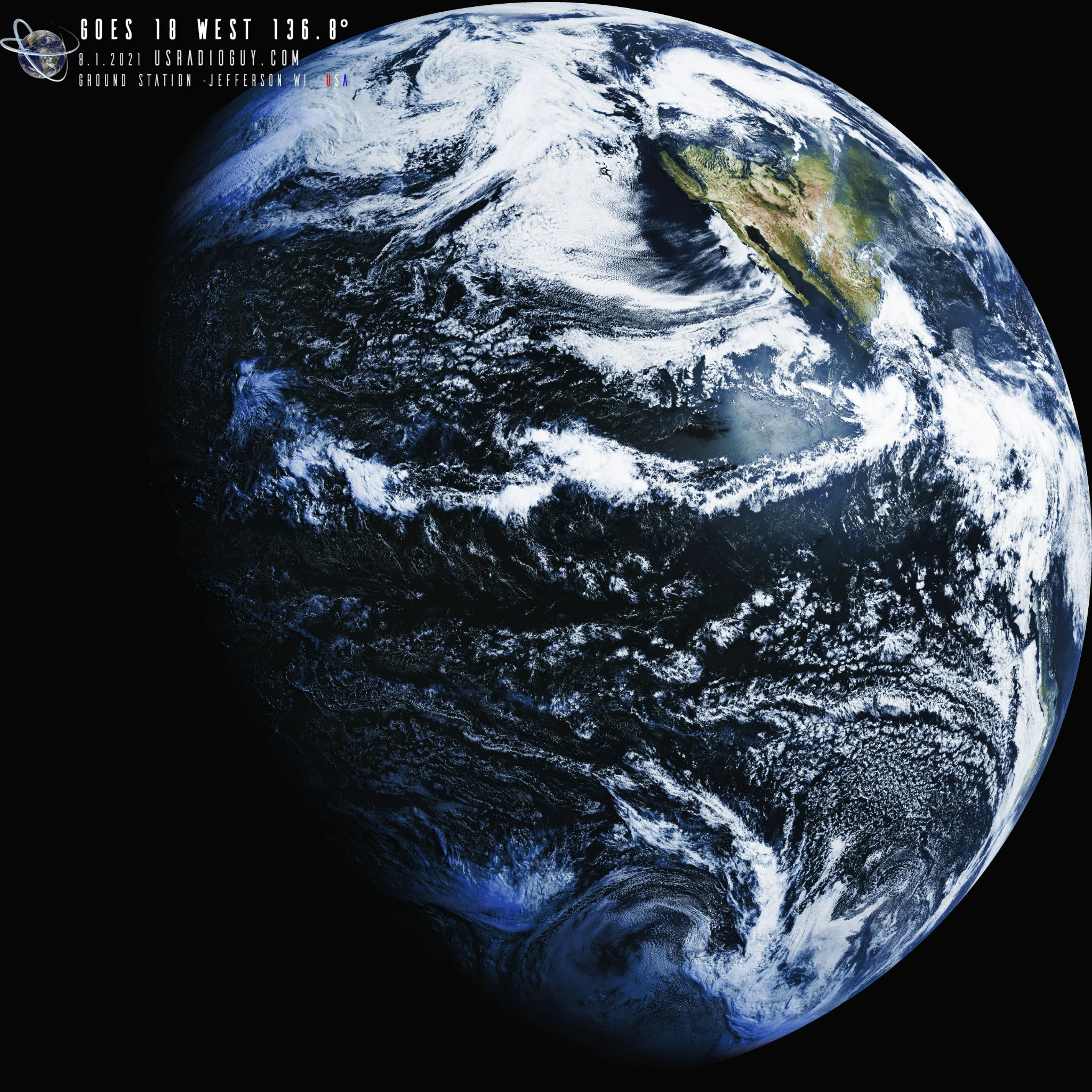
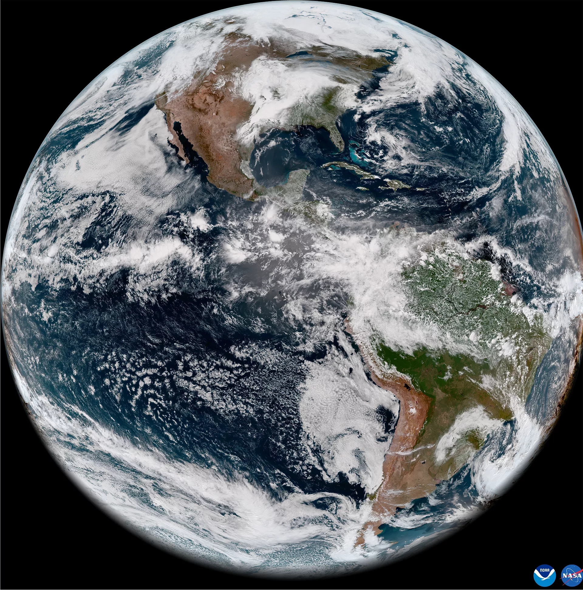
Skip to content
USRADIOGUY

USRadioguy.com

Welcome to USRadioguy.com – Unlocking the Potential of Software Defined Radio

  • Home
    • Home of USRadioguy
    • USRadioguy Newsletter
    • Tried and Tested Hardware
    • What is RTL-SDR?
    • Global Weather Data
  • Satellite Reception
    • Geo Stationary Satellites
      • Geo-stationary Satellite Imagery Reception
      • GOESTOOLS on the PI
      • Update Goestools for GOES 18,19
      • Receiving GOES with SatDump CLI Mode
      • GOES receiving in Windows for SatDump GUI
      • Decoding EWS-G1/EWS-G2
      • GOES GRB Reception WIP
      • Optimizing a WIFI Grid Antenna for Maximum Efficiency
    • APT Satellites
      • APT RECEPTION
      • Satdump for Meteor and NOAA decoding
      • METEOR M2- Series
      • WxtoImg Fix
      • Converting to new TLE format
      • Layering Fire and Hotspot Data on Meteor Sat Imagery
      • HRPT Satellite Tracking and Capture
    • Receiving Other Satellites
      • Inmarsat Decoding
      • Receiving the Funcube Amateur Satellite
    • User Maps and Dish Pointers
      • Satellite Dish Pointer
      • User Global Ground Station Maps
      • Usermap rendered with Cesium
      • Global Map of Govt Dish Stations
    • Satellite Details & Information
      • ORBITAL DYNAMICS 101
      • HRIT/EMWIN & GRB Defined
      • Mesoscale Imagery Defined
      • Viterbi, R/S Errors, Packets
      • GOES BAND IMAGERY
      • Stray Light Zone (SLZ)
      • Drifting a geostationary satellite
      • GOES-R Series Multimedia Tour
      • Online Satellite Imagery and Information
      • Satellite Frequencies
      • Solar and Space Weather
  • Satellite Imagery
    • IMAGERY- Current GOES East & West HRIT Satellite Imagery
    • IMAGERY- GOES 16&18 – Past 96 Hours of Imagery
    • High Resolution Imagery
    • Daily 3D view of Earth
    • NOAA APT Satellite imagery
    • PlanetMaker
    • GOES16 A full year of received imagery
  • Imagery Processing
    • Custom Color Lookup Table & Gradients
    • GOES-R Custom Imagery Scripts
    • Global geo-ring composites
    • MODIS VIIRS Global Coverage
    • 3D Satellite Tracking
    • The quest for True Color Imagery
    • 3D animation of realtime data
    • Layering Geo-Spatial Fire Data into Satellite Imagery
    • Orbital dynamics and the Moon
    • National Hurricane Data
  • News, VLOGS & BLOGS
    • News & USRadioguy Blogs
    • USRadioguy VLOGS
  • Project Lab
    • Orbital Information and Visualizations
      • Enhanced Planet Earth
      • Satellites in Orbit
      • Solar System
      • Objects in Orbit
    • Current Station Weather
      • Current Groundstation Weather
      • Global Weather Data
      • Space Weather
    • WWII RADIO
      • WWII K-24 Aerial Camera
      • WWII RADIO
      • RADIO SET SCR-284
      • VS-3 VIBRATOR CONVERSION
      • VIBRATOR CONVERSION MODULE
      • BD-71 Field Switch Board and EE-8B Field Telephones
      • R-100/URR 1944 MORALE RADIO
      • A PORTABLE WWII ERA “MORALE RADIO”
      • AN/GRR-5 THE ANGRY 5
      • WWII Audio Page
    • Raspberry Pi Projects
      • ADS-B Reception
      • Allsky Camera
      • Pi Based Picture Frame
      • PI Based Broadcastify Server
      • Solar Power for PI
    • Hubble Space Telescope Data Processing
    • Zombie Satellites
    • DRONES
  • About Me
    • About Usradioguy
      • SETEC Astronomy
    • Tried and Tested Hardware
    • Rare Captures
    • My Other Interests
    • Presentations
    • Merchandise
    • Privacy Policy
  • Home
  • Usradioguy Blogs
  • Page 7
News
End Of Life for NOAA 15,18,19?….not so fast…
April 25, 2025
News
GOES-19 now GOES-EAST
April 7, 2025
Satellites
GOES 19 Operational Schedule
March 27, 2025
Interesting stuff you should know!
Update – Goes 16 to19 Transition to Operations
March 4, 2025
CCOR-1
Interesting stuff you should know!
GOES-19 CCOR-1 Coronagraph Preliminary Non Operational Data
February 8, 2025
Imagery Processing
Cloud-Based Geo Sat Processing using Satdump
December 9, 2024

Usradioguy Blogs

Going Green, and to Extremes!

Posted on August 15, 2022April 6, 2025 By Carl
Going Green, and to Extremes!
Hardware, Interesting stuff you should know!, Life, Science

Loading

Going Green, and to Extremes! Sometimes, you just have to share, and this really deserves to be seen! A Self-Sufficient Sentinel: Manuel Lausmann’s Remote Satellite Ground Station in Arctic Norway In the remote and challenging environment of Sør-Helgeland, North Norway (JP65EQ), Manuel Lausmann (DO3MLA) has constructed a remarkable, self-powered satellite ground receiving station. This installation … Delve Deeper “Going Green, and to Extremes!” »

GOES-18 HRIT- First Light Imagery

Posted on June 15, 2022June 15, 2022 By Carl
GOES-18 HRIT- First Light Imagery
Satellites, Science

Loading

GOES-18 HRIT- First Light Imagery As planned, GOES-18 completed its slow drift after its first phase of post-launch testing (PLT). Arriving at 136.8° West, GOES-18 is in position for its second round of PLT’s. GOES-18, which launched on March 1, 2022, was initially delivered to 89.5 degrees west over the Central U.S. and began post-launch … Delve Deeper “GOES-18 HRIT- First Light Imagery” »

GOES-18 First Light Imagery

Posted on May 11, 2022May 11, 2022 By Carl
GOES-18 First Light Imagery
Satellites, Science

Loading

Earth from Orbit: NOAA Debuts First Imagery from GOES-18 May 11, 2022 On May 11, 2022, NOAA shared the first images of the Western Hemisphere from its GOES-18 satellite. The satellite’s Advanced Baseline Imager (ABI) instrument recently captured stunning views of Earth. GOES-18, NOAA’s newest geostationary satellite, launched on March 1. The ABI views Earth with sixteen different … Delve Deeper “GOES-18 First Light Imagery” »

GOESRECV-PS

Posted on April 28, 2022April 28, 2022 By Carl
Satellites

Loading

A collection of PowerShell scripts for doing cool things with Pieter’s goestools software. Wanted to share this work posted over on Github by JVital2013. A series of power shell scripts that work with goestools. The first and most useful to me right now is goesrecv-rtltcp.ps1 This script allows you to monitor the RF spectrum of … Delve Deeper “GOESRECV-PS” »

AWS-1 , AWS- 3 and LIGADO interference and HRIT/GRB, HRPT

Posted on March 23, 2022July 10, 2024 By Carl
AWS-1 , AWS- 3 and LIGADO interference and HRIT/GRB, HRPT
Interesting stuff you should know!, News, Satellites, Science

Loading

UPDATED 05-04-2022 Electromagnetic interference (EMI) refers to the disruption of a system’s operation due to an electromagnetic field created by the same or another electronic system. EMI is common and can affect any electronic system. The fifth generation of mobile technologies (5G) is no exception. 4G and 5G deployments can cause serious EMI issues too, … Delve Deeper “AWS-1 , AWS- 3 and LIGADO interference and HRIT/GRB, HRPT” »

NOAA’s GOES-T Reaches Geostationary Orbit, Now Designated GOES-18

Posted on March 14, 2022March 14, 2022 By Carl
NOAA’s GOES-T Reaches Geostationary Orbit, Now Designated GOES-18
Uncategorized

Loading

GOES-T Reaches Geostationary Orbit, Now Designated GOES-18 On March 14, 2022, GOES-T executed its final engine burn, placing the satellite in geostationary orbit 22,236 miles above Earth. Upon reaching this milestone, GOES-T was renamed GOES-18. GOES satellites are designated with a letter prior to launch and a number once they achieve geostationary orbit. NOAA’s GOES-T satellite launched on … Delve Deeper “NOAA’s GOES-T Reaches Geostationary Orbit, Now Designated GOES-18” »

GOES-U on track for April Launch

Posted on March 3, 2022June 25, 2023 By Carl
GOES-U on track for April Launch
Satellites, Science

Loading

UPDATE May 3, 2023 GOES-U Completes Solar Array Deployment Test This critical test verified that the satellite’s large, five-panel solar array — which is folded up when the satellite is launched — will properly deploy when GOES-U reaches geostationary orbit. During this test, engineers unfurled the five panels on rails that simulated the zero-gravity environment … Delve Deeper “GOES-U on track for April Launch” »

GOES-T Launch Photos

Posted on March 2, 2022March 2, 2022 By Carl
GOES-T Launch Photos
Satellites, Science

Loading

Photographer Nicholas D’Allesandro graciously allowed me to share a few of his AMAZING launch photos. Also included are a few press photo’s from NASA, NOAA, and United Launch Alliance. Preview in new tab The Last view of GOES-T ~ SPACECRAFT SEPERATION!T+plus 3 hours, 32 minutes, 55 seconds.

GOES-T Launch a success!

Posted on March 1, 2022March 1, 2022 By Carl
GOES-T Launch a success!
Satellites, Science

Loading

GOES-T, soon to be GOES-18, was successfully launched on March 1, 2022, at 4:38 p.m. EST from Space Launch Complex 41 at Cape Canaveral Air Force Station, Florida aboard an Atlas V 541 rocket. It was United Launch Alliance’s 149th mission, the 38th for Launch Services Program, and the 92nd launch of Atlas V. The Atlas … Delve Deeper “GOES-T Launch a success!” »

GOES-T Roll Out and Fueling

Posted on February 28, 2022February 28, 2022 By Carl
GOES-T Roll Out and Fueling
Satellites, Science

Loading

GOES-T on the Launchpad After Rollout GOES-T was rolled out to the launchpad from the ULA Vertical Integration Facility (VIF) on Feb. 28, 2022. Photos by United Launch Alliance Atlas RP-1 Loading Begins Fueling of the Atlas V first stage is underway at Cape Canaveral’s Space Launch Complex-41. The launch team is pumping 25,000 gallons … Delve Deeper “GOES-T Roll Out and Fueling” »

Posts pagination

Previous 1 … 6 7 8 … 10 Next

Please, Help Support USRadioguy.com

If you like what I do please support me on Ko-fi, It really means a lot, every bit helps!

Hardware Humor Imagery Processing Interesting stuff you should know! Launch News Life News Product Review Satellites Science Software Space Weather Uncategorized VLOG

Alphabetical Listing of all Pages on site:

  • 36-Hour Imagery Processing script
  • 3D animation of realtime data
  • A PORTABLE WWII ERA “MORALE RADIO”
  • About Me
  • ADS-B Reception
  • Allsky Camera
  • AN/GRR-5 THE ANGRY 5
  • BD-71 Field Switch Board and EE-8B Field Telephones
  • Current GOES 16 & 18 False Color Satellite Imagery
  • Custom Color Lookup Table
  • Custom Imagery Scripts for GOES
  • Daily 3D view of Earth
  • Daily Global Composites
  • Decoding EWS-G1 or GOES-13
  • Drifting a geostationary satellite
  • DRONE FUN
  • Even the kitchen sink
  • GEO-RING COMPOSITES
  • GEO-SAT PI FRAME
  • Geo-stationary Satellite Imagery Reception
  • Global Weather Data
  • GOES 19&18 – Last 96 Hours of Imagery
  • GOES BAND IMAGERY
  • GOES GRB Reception
  • GOES receiving in Windows for SatDump
  • GOES-18 Preparing for a new satellite
  • GOES-R Series Multimedia Tour
  • GOES-U (19) Countdown to Launch
  • GOES16 A full year of received imagery
  • Ground Station Map
  • High Resolution Imagery
  • Home
  • House History
  • HRIT/EMWIN & GRB
  • HRPT Satellite Tracking and Capture
  • Hubble Space Telescope Data Processing
  • Inmarsat Decoding
  • Layering Fire and Hotspot Data on Meteor Sat Imagery
  • Layering Geo-Spatial Fire Data into Satellite Imagery
  • Mesoscale Imagery Defined
  • METEOR M2- Series
  • MODIS VIIRS Global Coverage
  • My Other Interests
  • NASA, NOAA, Military, GOVT dish, and tower stations.
  • National Hurricane Data
  • Newsletter terms & conditions
  • NOAA & Meteor APT and LRPT RECEPTION
  • Online Satellite Imagery and Information
  • Optimizing a WIFI Grid Antenna for Maximum Efficiency
  • ORBITAL DYNAMICS 101
  • Orbitron, Gpredict, and PSTRotator with new TLE format
  • PI Based Broadcastify Server
  • Pi Based Picture Frame
  • Presentations
  • Privacy Policy
  • Programming the PI for goestools operation
  • R-100/URR 1944 MORALE RADIO
  • RADIO SET SCR-284
  • Rare Captures
  • Receiving GOES 18,19 with goestools
  • Receiving GOES HRIT with SATDUMP
  • Receiving the Funcube Amateur Satellite
  • Satdump for Meteor and NOAA decoding
  • Satellite Finder
  • Satellite Frequencies
  • Satellite Ground Stations
  • Satellite Tracking
  • Security
  • SETEC Astronomy
  • Solar Power for PI
  • South America GOES 16
  • Space Weather
  • Stray Light Zone (SLZ)
  • Thanks!
  • The quest for True Color Imagery
  • Tried and Tested Hardware
  • Usradioguy Blogs
  • Usradioguy Merchandise
  • USRadioguy Newsletter
  • USRadioguy VLOGS
  • USRADIOGUY Youtube Page
  • VIBRATOR CONVERSION MODULE
  • Viterbi, R/S Errors, Packets
  • VS-3 VIBRATOR CONVERSION
  • What is RTL-SDR?
  • WWII Audio Page
  • WWII K-24 Aerial Camera
  • WWII RADIO
  • WxtoImg Fix
  • Zombie Satellites

Hardware Humor Imagery Processing Interesting stuff you should know! Launch News Life News Product Review Satellites Science Software Space Weather Uncategorized VLOG

Satellite And Weather Related Feeds

  • CIMSS Satellite Blog
  • USRadioguy.com
  • wildfires
  • NASA Earth Observatory
  • SPC Particularly Dangerous Situation (PDS) Tornado/Severe Thunderstorm Watch
  • satellites
  • Satellites News -- ScienceDaily
  • Satellite Liaison Blog
Using Polar2grid and Direct Broadcast files to create imagery
Cirrus over the western Great Lakes
Wildfire in Saskatchewan produces a pyrocumulonimbus cloud
End Of Life for NOAA 15,18,19?….not so fast…
GOES-19 now GOES-EAST
GOES 19 Operational Schedule
The fire cycle
March was nation's 6th warmest on record
Podcast: Could the LA Wildfires harm California's marine life?
Mapping the Tiny Plankton That Feed Giant Right Whales
Lights of Southeast Asia
The Arches That Salt Built
SPC PDS Tornado Watch 98
Five historically huge solar events
65 years since the world’s first weather satellite
Investing in America: NOAA's Science, Service and Stewardship in Action
Satellite measures CO2 and NO2 simultaneously from power plant emissions for the first time
Existing international law can help secure peace and security in outer space
Small, faint and 'unexpected in a lot of different ways': Astronomers make galactic discovery
Another Week, Another Deep South Soaker
4 May 2025 Dust and Accumulating Hail
Southern Plains Deluge
  • Facebook Geo Stationary Satellites
  • Usradioguy Facebook
  • Instagram
  • Reddit
  • Github
  • Linkedin

Copyright © 2025 USRadioguy.com - All Rights Reserved. All material protected by Fair Use Section 107 of the Copyright Act. This site is Verified and Secured with 256 bit SSL encryption